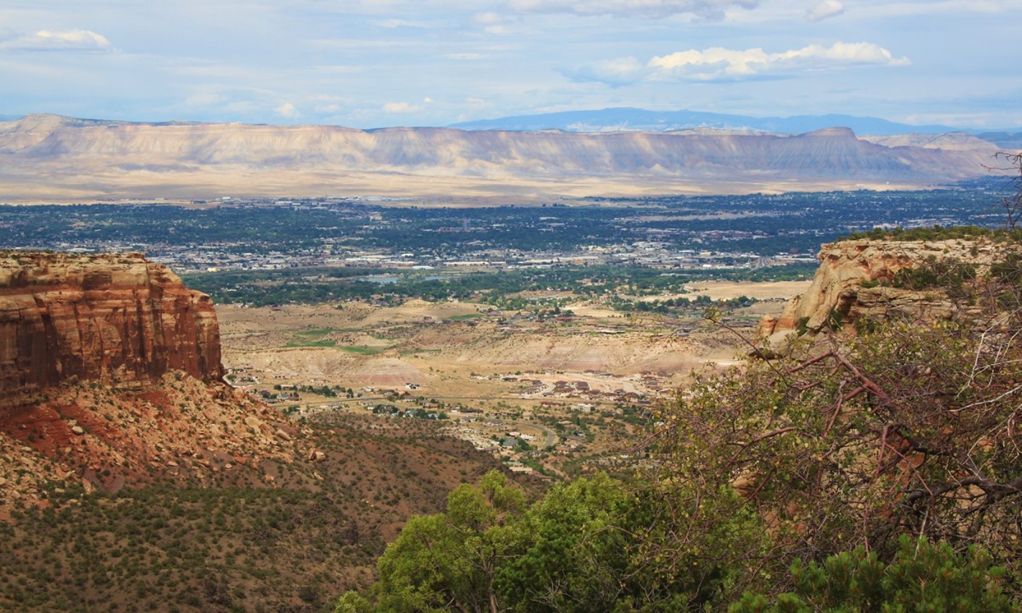
Having just returned from Patagonia and the Chilean Fjords, we quickly readied ourselves for a Saturday, February 2nd flight back to South America.From New Orleans, we flew to Atlanta and then Sao Paulo, Brazil, where our connection left us only 80-minutes to clear international immigration, pick up luggage, clear customs re-check the luggage, and race to the gate for our 1 ½ hour domestic flight to Iguassu Falls, Brazil!We arrive at the gate just as the staff start the boarding process.
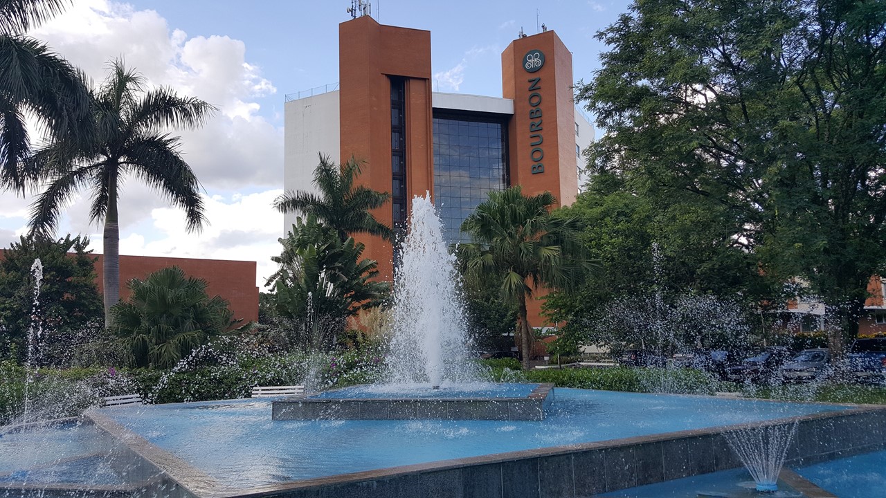
The airport in Iguassu Falls is being totally reconstructed. Luckily, our luggage also arrived, and we are then off to find Veronica, our guide for this trip. Our total group are only 4 people which will make for an interesting and intimate excursion.It is only a 10-minutes to our hotel, the “Bourbon”, which is lovely with huge trees shading the front drive, and a very green interior of lush vines and vegetation.The hotel is quite large with its own convention center, 5 dining spaces, and 2 pools (one out door and one indoor (heated). There is a full spa and gym as well as a vegetable garden and orchard, 3 hiking trails, tennis, volleyball, soccer fields, a jungle zip line and rope course, an aviary, mini-zoo, and a child’s play area that includes a tree house, rock climbing wall, cinema, and game/activity center.As it is Sunday and, although the city is almost 250,000 people, most of its shops downtown are closed, and we walk, instead, away from town, to the local shopping mall and found a small restaurant that served Brazilian shawarmas for lunch.After returning to the hotel, we used the afternoon to hike the hotel’s trails and then took a swim in the heated pool. Later we met up with our guide Veronica to learn the next day’s plan and meet the other 2 guests (Al & Sherilyn) in our party.We celebrated with a native Brazilian welcome drink – a Caipirinha – served with a nibble of warm nuts.Dinner that night was a buffet in the hotel’s restaurant.
The Bourbon Hotel in Iguassu Falls – Brazil
Brazilian Parrots Roaming behing the Hotel
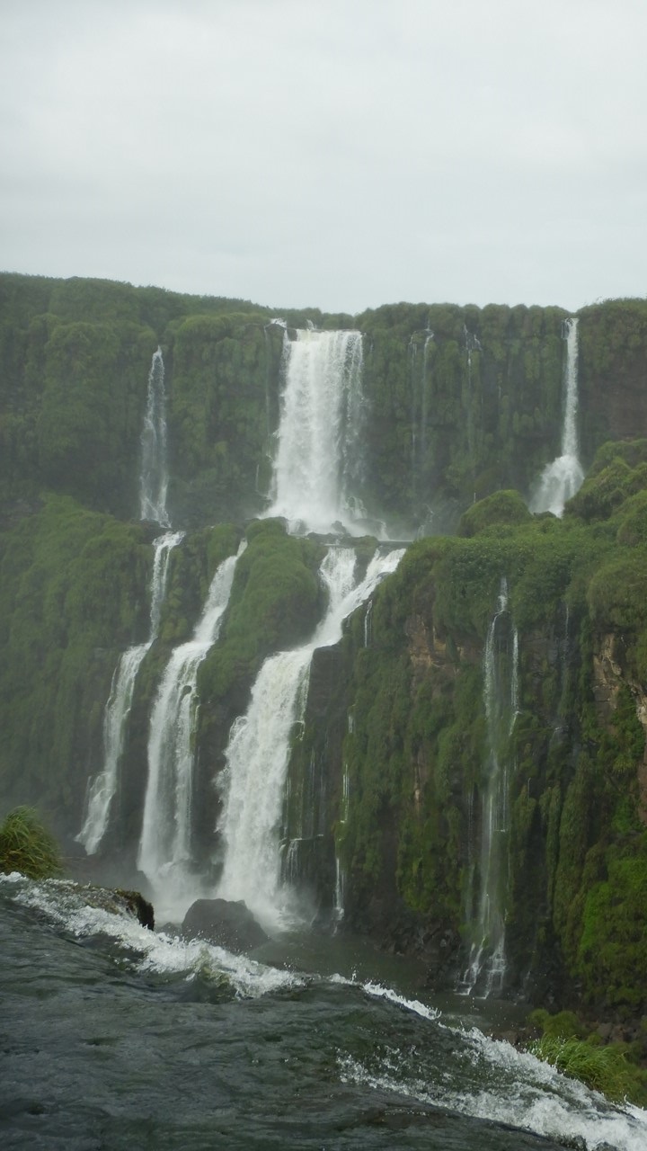
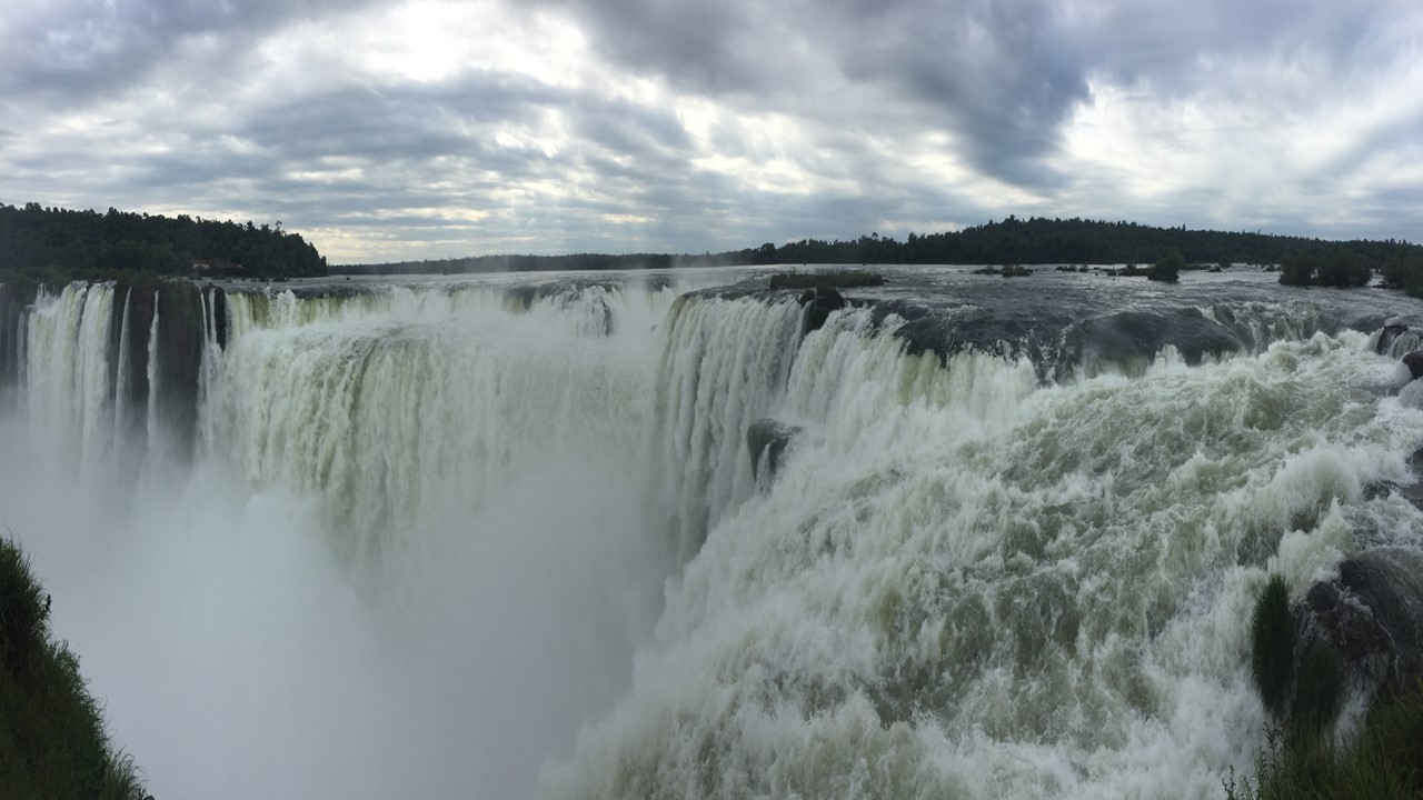
Tuesday after breakfast, our guide introduced us to our bus driver, Eduardo, who drove us to the Brazilian National Park at Fox de Iguassu – “the confluence of 2 rivers”. Here, the Pianera River meets the Iguassu River and forms the border between Argentina, Brazil and Paraguay.The Iguassu Falls are downstream of the junction of these rivers and is still the border between Brazil and Argentina.From here, the river continues its journey to eventually join the River Plata. Both countries have National Parks around the Falls, and the Park is surrounded by a larger buffer zone to protect the local flora and fauna.Most of the buffer zone was originally used for farming, but increasingly is being put aside and allowed to recover naturally.In 1986, UNESCO declared the area a World Heritage Site.Iguassu Falls normally delivers only 1/8 the volume of Niagara Falls, but in size is the second largest to Victoria Falls in Africa.There are actually over 275 individually named waterfalls here with the Brazilian side encompassing ~100,000+ hectares, and the Argentinean side another 60,000 hectares. The Falls are over 2-miles wide and were first described by a Spanish explorer, Alvar Nunez, in 1542.He originally named them the “Holy Mary” waterfalls. The Brazilian side was named a park in 1939.
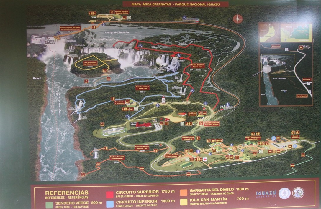
Map of Iguassu Falls and the Trails on each side of the Border
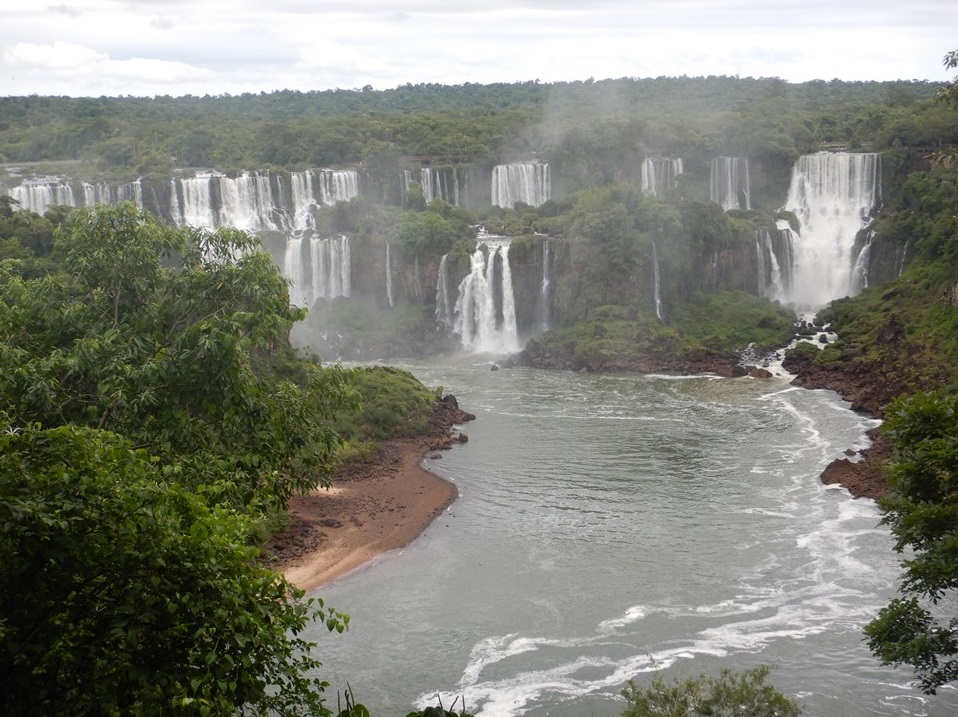
View of Iguassu Falls from Brazil
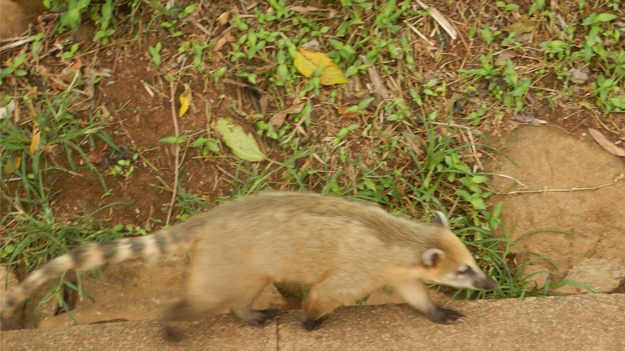
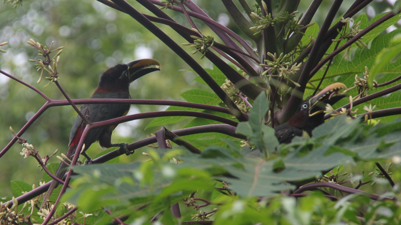
The parks are populated with many native species, including toucans, jaguars and quati – a racoon-like animal that roams all over the park looking to scavenge or even steal an unsuspecting person’s lunch. In 2001 there were 41 jaguars in the park, but their numbers have grown and 95 now call the park their home.Other species are also doing well in the park, including a number of local palm trees that used to be killed and harvested for their palm heart.Today, this food crop has been replaced by a more tolerant species of palm grown in the north of Brazil.Also, the acai plant grows wild here, and is useful as an antioxidant, for skin care, and in the treatment of adult diabetes.
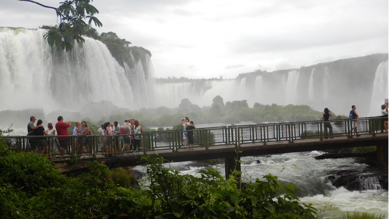
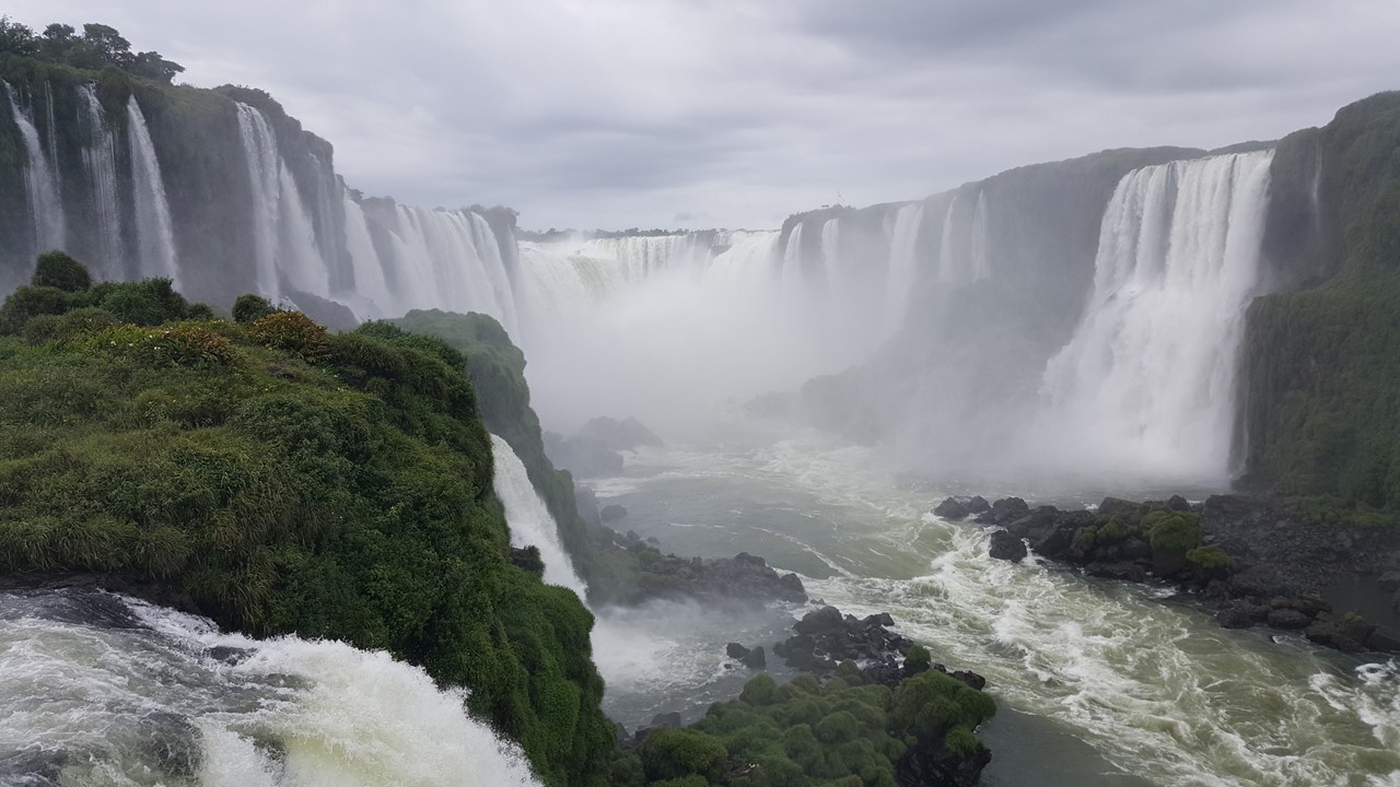
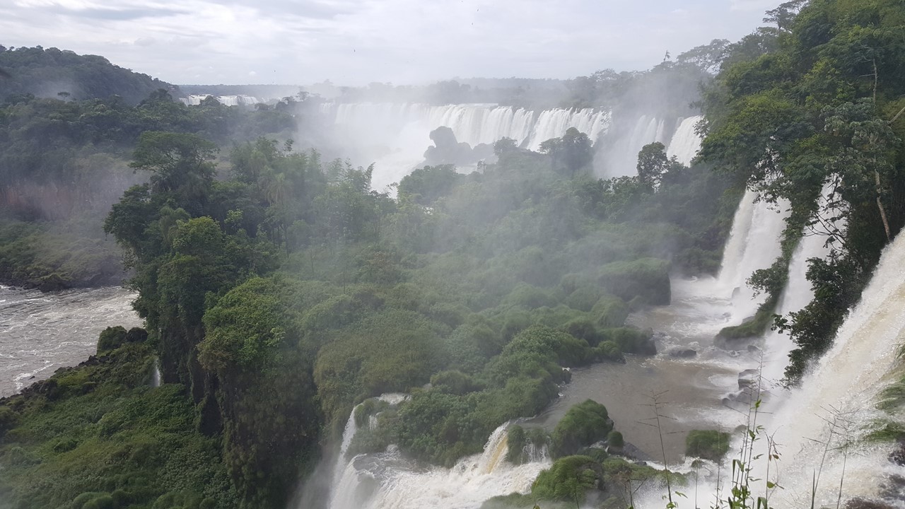
After we arrive, we begin a walk to the river’s side when we come upon our first large and colorful Toucan. Our first view is of “the Three Musketeers”, a lower tier of three falls where our boat excursion the next day will take us.Next, we come upon a viewpoint of “the Devil’s Throat”, a 2,300-foot long spectacular narrow canyon where the torrents crash in from 3 sides and the spray is like a hurricane rainstorm.The Brazilians have built a walkway out over a ledge facing these falls and the view is breathtaking and wet.We then take the glass elevator up to the main park road where we visit a small food court for lunch.Here we ordered salami baguette and fries with a beer and a caipirinha, all while protecting our lunch from thieving quatis.
Brazilian Walkway to View The Devil’s Throat
The Devil’s Throat from Brazilian Side
The Three Muskateers Falls – We boat under the right one
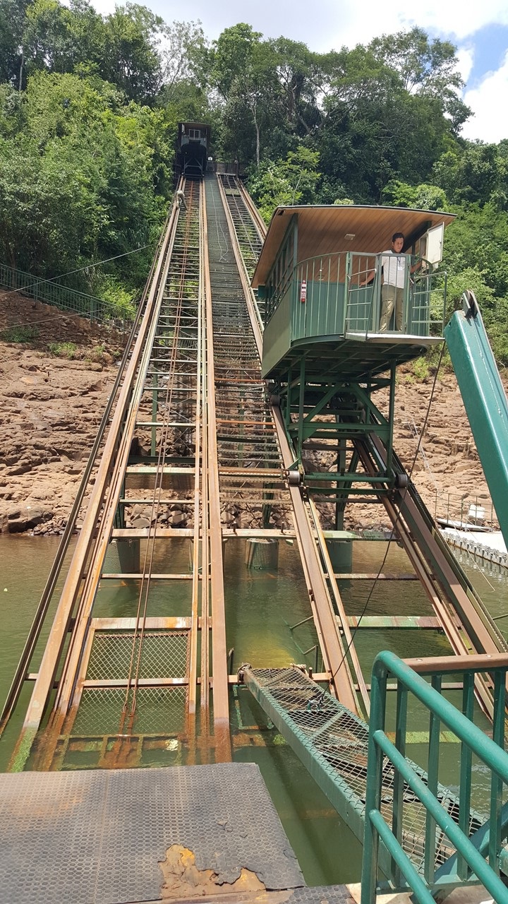
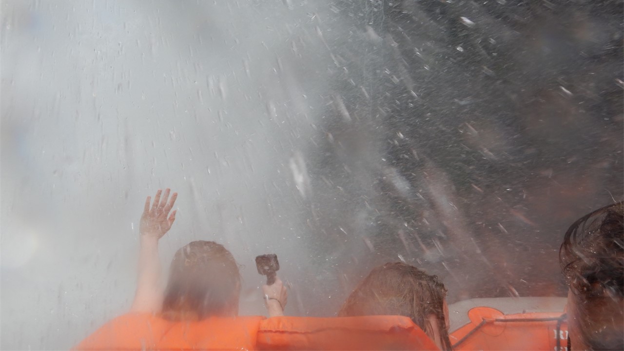
After lunch, we take a little tram jungle tour through the park’s secondary rain-forest, as the park does not allow any tourism in the primary rain-forest.Here there is a strong conservation effort trying to preserve the rain-forest as there are less than 20 trees left here that are over a hundred years old. Historically, trees in this rain-forest had been cut for their wood, and these species grow very slowly. After our tour, we transfer to an old Jeep and head down closer to the river’s cliff-face where we board a funicular that takes us down to the river’s edge.Here we put on life-jackets and then board a special zodiac with twin mercury engines. We cruised down the river to “the Three Musketeers” water-falls and run the boat first next to and then under the first of the falls.This is then followed by a wild ride through some of the rapids and a series of “donuts” on the water for a thrilling river ride.After drying-off, we return back to our bus via Jeep and tram.
Funicular to the Iguassu River to boat to the Falls
Boating under the Three Muskateers Falls
Dinner that night was on our own, so we again walked to the local shopping mall and had a Churrasco meal-for-two with chicken, pork and steak including fries, rice and salad and ice cream for dessert. It was much more food than we had expected, and we were glad that we could walk some of it off as we headed back to the hotel.
Wednesday morning, we were up early for a buffet breakfast prior to readying ourselves to cross into Argentina to see the Falls from the other side.In order to execute this, we drive to Brazil’s Border Crossing, exit the bus and present ourselves to Brazil Immigration, then re-board the bus and drive a short distance to the Argentina Border Crossing and do the same. When crossing the bridge over the river border, the bridge changes colors from yellow & green to blue & white.Along the river are people fishing for surlie, dorado, and pachoo, some weighing-in at over 100 pounds.
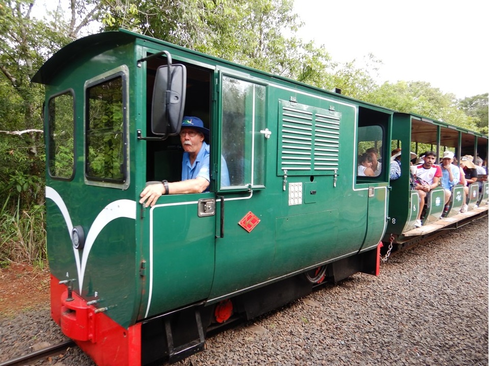
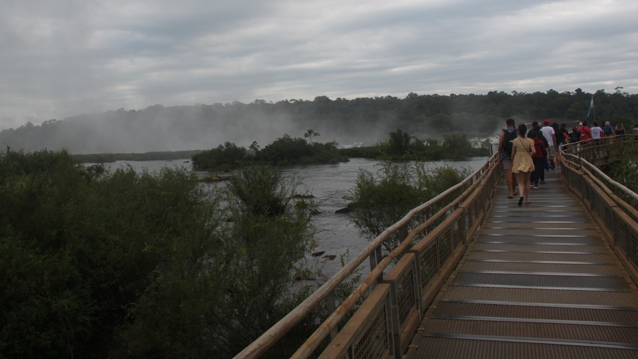
The Argentinian side of the falls was named a park in 1934 and declared a UNESCO World Heritage Site in 1984.By regulation, each side of the park has only a single resort/hotel, and it must meet “green” requirements to remain open within the Parks’ boundaries. When we arrive, it is 8:30am and the there is a huge line of vehicles waiting to enter the park.We enter nearly first and after walking through the gates, we board a small-gauge train to transport us through the pristine rainforest to the site of the Falls located at the 3rd stop.From here, we hike ~1100 meters to the other side of “the Devils Throat” along a well-built “moonwalk trail”.From this side we are at the top of the Falls looking down into “the Devil’s Throat” and again immersed in a rainstorm of spray.After finishing this “loop”, we take the train back to the first train station and walk the Superior/Upper trail (~1750 meters long loop) to see Falls up close where yesterday we viewed them from across the gorge.A number of places were looking over the edges of the Falls, and the mist provided for a damp picture-taking day.Upon completing the Upper Loop, it was time for lunch at a small food court, where we had empanadas and cervasas.
The Argentinean Ecological Train to the Falls
Argentinean Walkway to the Top of The Devil’s Throat
Overlooking The Devil’s Throat from Argentina
After lunch we headed to the Lower Trail (`~2300 meters long loop) that takes us past the Argentinean Viejo Hotel. This hotel was first built and opened in 1919 but was closed in 1978 because it was too small to receive World Cup visitors. It was then that the new hotel/resort opened. In 2017 they reopened the old Viejo Hotel as a Park Office and as a place to give Park Researchers additional space from which to work. As we walked, we saw four Chestnut Arasari Toucans (not as colorful as the yellow billed toucan) and then we saw Plush Crested Jays. We continued own walk down the Lower Circuit of the Falls where we had great views of San Martin Island and Falls named: Salto Bossetti, Salto Eva, Salto Adan, Alvar Nunez, Salto Chico, and Salto Mbigua.
Two Chestnut Arasari Toucans
The Second Level of Falls from Argentinean Lower Circuit
Argentinean Circuits allow Close Experiences with Many Falls
After a long day of walking, we returned to the hotel, again passing immigration in Argentina and then re-entering Brazil (for which our visa was required) and then onto our hotel.That night, we had a group dinner at the hotel for our last night in Brazil.
The next morning, Wednesday, February 6th, we meet in the lobby at 9:30am for our bus departure again to the Argentinian border.We are flying from Iguassu Falls on the Argentinean-side of the border to take a domestic flight to Buenos Aires.We clear Brazil customs and Argentina immigration smoothly, just like the previous day.However, when passing through the border, we notice a huge traffic line of vehicles trying to cross into Brazil stretching miles long.Further down the highway we begin to see cars and buses parked on the side of the road and several are turning around.When we pass the Argentinean National Park Entrance that we visited the day before, it is closed and protected by numerous Park Officials sitting in their cars and with Police in riot gear lining the road. All around the Park’s entrance there are protesters who are objecting to a plan for a new “Native Village” to be developed in the park.This native village would cause locals with businesses outside of the park to lose business and income, since it would centralize tourism even more within the park and keep the profits internally.It might also potentially jeopardize their UNESCO World Heritage Site status.Since the park knew of the planned protest, it was closed to visitors, which is why the buses and cars were parked on the surrounding roadsides, and why some are trying to visit the Brazilian park instead.Many tourist buses are parked, hoping the protest would soon end and the park would reopen. Luckily, we are able to make our way through and arrive at the local airport, which is very small (only 2 gates).From here we board our flight and head to Buenos Aires for the next adventure.
For a number of years, we had been looking for a trip to South America that included Easter Island – a location to which we wished to travel and visit.When the opportunity arose, we scheduled this trip beginning on Sunday, January 7th, 2019 and lasting 3 weeks.Our trip would start from Miami, take us to Santiago, Chile and then to Rapa Nui (Easter Island) and back to Santiago.From there, we would fly to Buenos Aires, Argentina and, after a few days, travel to Ushuaia, Argentina where we would board with 150 passengers on the ship, “The Stella Australis”.For five days we would then explore southern Patagonia, Tierra del Fuego and the Chilean Fjords before disembarking in Puenta Arenas, Chile and traveling overland to the Torres del Paine National Park.From here, we would travel to El Calafate, Argentina to explore Los Glaciares National Park and the Perito Moreno Glacier. We would then return to Buenos Aires before returning home through Miami.
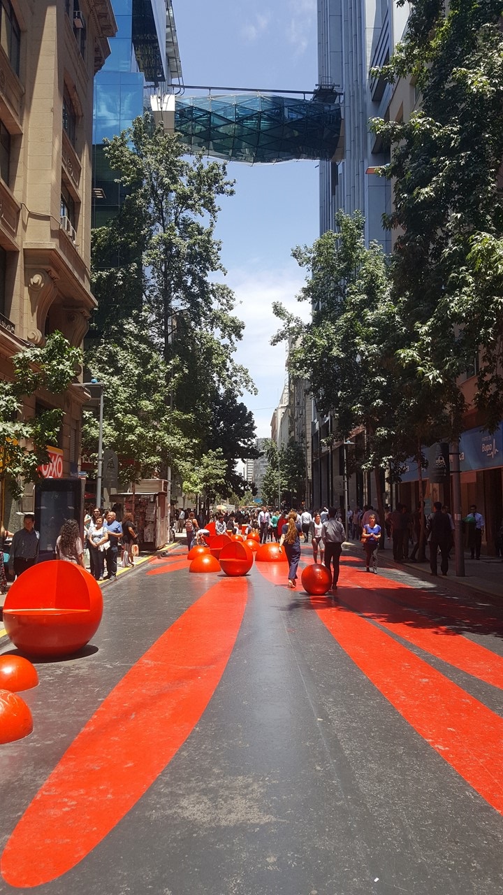
Our trip began auspiciously enough as, after we drove 3-hours to Miami International Airport, we boarded our plane to Santiago, Chile, and we immediately met with an engine problem which resulted in an over 2-hour delay forcing us to return to the gate for repairs.Once underway, we flew overnight to Santiago, Chile and were met late Monday morning by our guide, (Mercedes, or “Mechy”) an energetic Argentinean woman with passion, wit and humor.Here we met our fellow 14 travelers for a quick walking tour of the city.Our “local guide”, Felippe, took us on the city’s subway to the city-center, where walked past the many shops of La Moneda to the Presidential Palace (the President no longer lives there).Here we saw the Statue of Salvadore Gossen who is credited with writing the Chilean constitution. However, in 1973 the country’s “leftist” government experienced a coup d’état which included bombing, air force raids and military snipers (likely paid for by the USA’s CIA) downtown on the Palace. With the new Military rule, the USA wielded significant influence for the next 17 years.During this time, Chilean culture went underground, and it wasn’t until 17 years later that democracy finally ruled, and the underground cultures could emerge. Today, car, houses, phones and all the trappings of a socially upward mobile society, paid for with credit, is the norm.Many Chileans aspire for a life imitating what they see in American movies, but with a 19% National Sales Tax that is included in everything one buys. 1990 until today has also seen the nationalization of the minerals industry (principally copper mines) and the success and growth of the Chilean Wine Industry.
City Center Pedestrian Street in Santiago
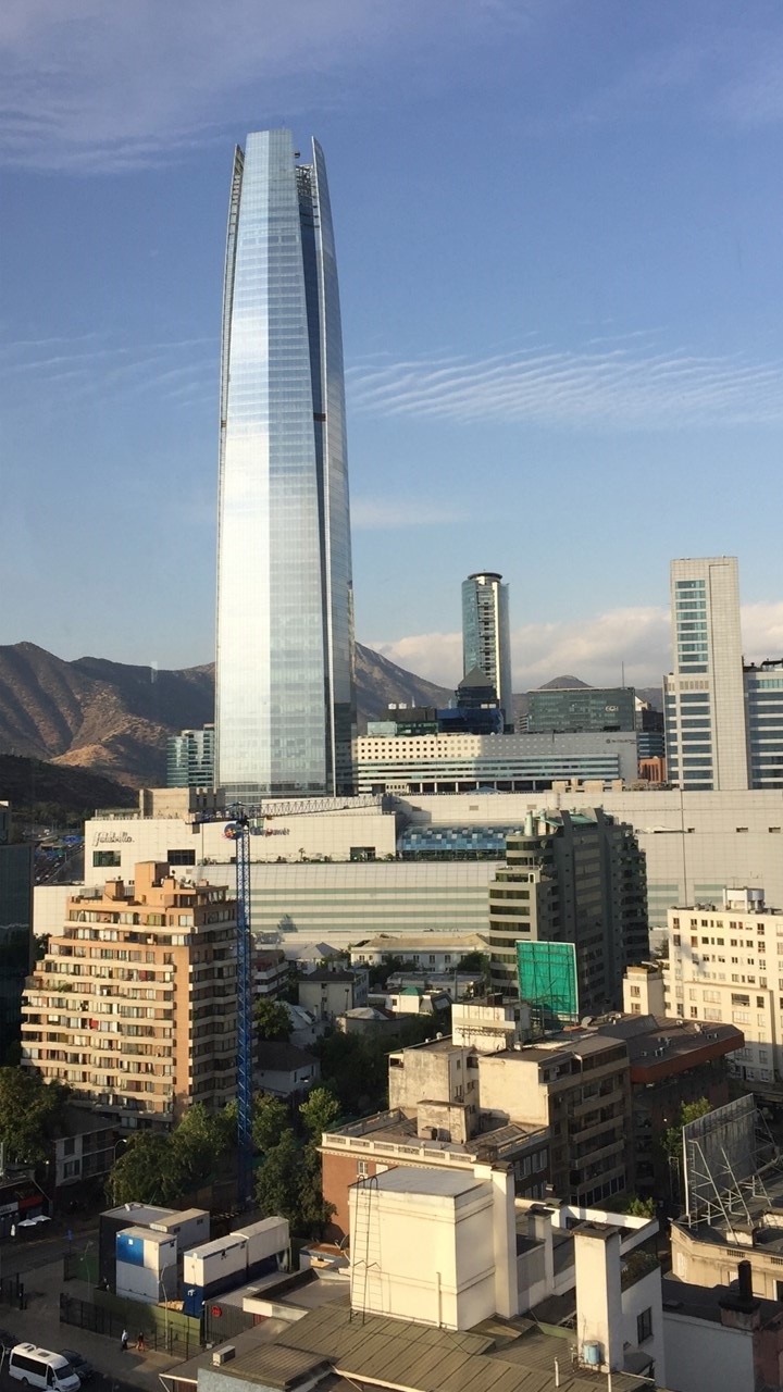
View of S. Hemisphere Tallest Building
Today, the city’s main square houses a restored and rebuilt Presidential Palace, a Church (The Cathedral of Santiago), other government buildings, and the National Historical Museum.After exploring the history of the square, we rode the subway back to hotel, where we then had a few hours to explore on our own. We checked out the local mall and Starbucks, before settling at a nearby little Italian restaurant, “Don Vito’s”, where we drank “happy hour” Pisco Sours and relaxed in the sunshine. Later that evening, we met the rest of our group and had a short meeting on regarding the next day’s activities, enjoyed a glass of champagne and then walked to Giratorio- a revolving 17th floor restaurant about 10 blocks away – for dinner.Here we drank more Pisco sours and enjoyed a fish dinner with fruit and vegetables and a fruit plate for dessert, all while rotating one revolution per hour to get a complete view of the city.
The next morning, we must say “goodbye” to Santiago, and we travel to the Chilean island of Rapa Nui – Easter Island – to continue our adventure. Five days later we will return briefly to Santiago, but only to make an early morning transfer at the airport and to fly to Buenos Aires, Argentina.
The Andes Santiago to Buenos Aires
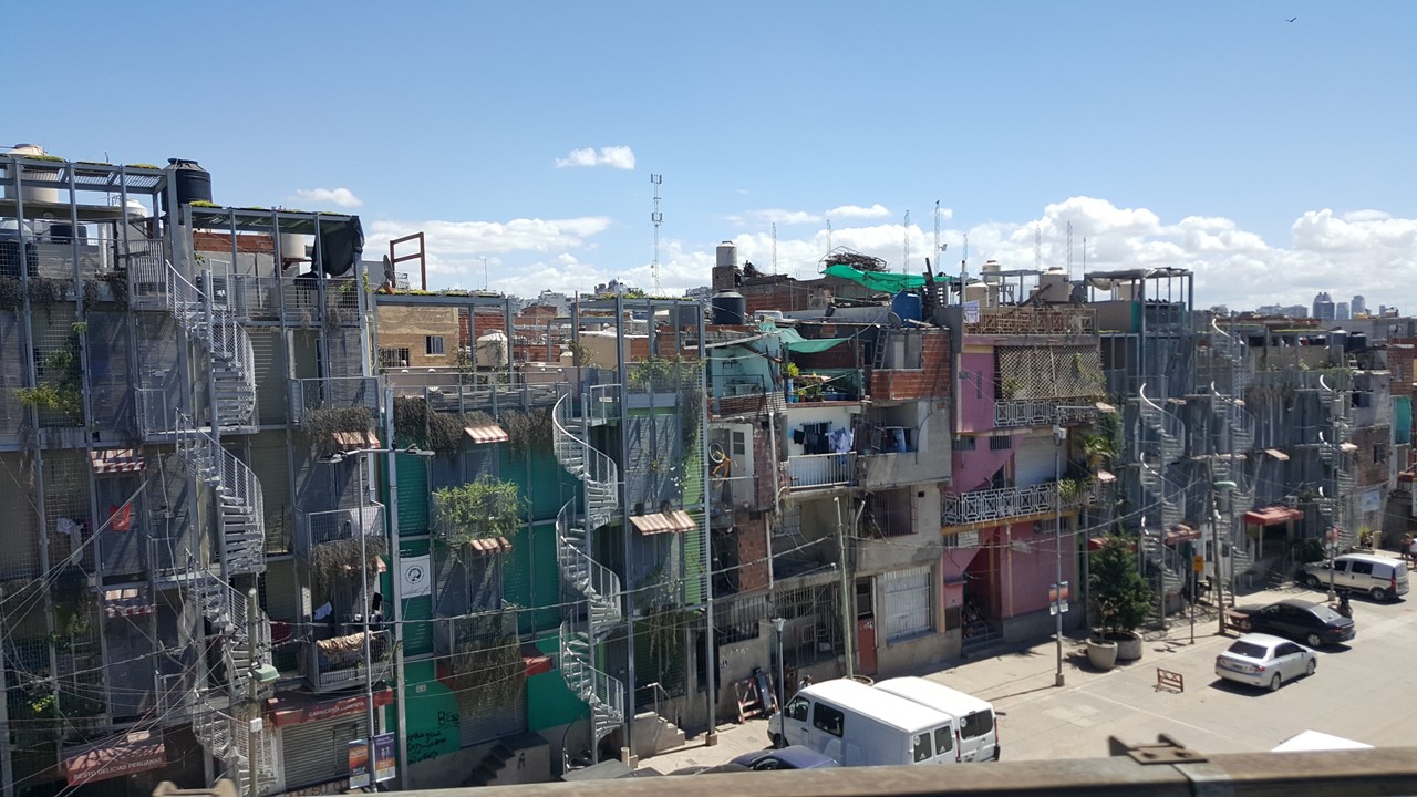
Buenos Aires Slums
Once in Buenos Aires, we check into the hotel, and then set out to walk to the famous Teatro Colon – the city’s world-class Opera House.The tickets will be for the next day, so we continue our walk to a bookstore that is in an old 1919 theatre that has been beautifully restored.The “Ateneo Grand Splendid” is stunning (and is known as the world’s most beautiful bookstore) that even sells vinyl records. From there we visited a few local shops at the nearby mall (Galerias Pacifico) which has a fresco/mural ceiling painted by 5 renown painters.Then we return to the hotel for a group meeting, (22 of us now) and follow this with an hour’s worth of basic tango lessons.
The Ateneo Grand Spolendid Bookstore
Buenos Aires is a large city whose metropolitan area includes nearly half the population of country! From the hotel, we walked to the old waterfront of the River Plata (the Silver River).The La Plata River forms the border between Argentina and Uruguay, but Uruguay is a small country and has many fewer people in the region. In this area, Puerto Madero, a large canal for ships was dug and was outfitted with cranes and warehouses. The intent was to provide a world-class hub for goods coming from the interior of South America to be able to be quickly transferring on ocean-going ships. However, by the time the port was finished, the size of ocean-going ships exceeded to port’s width and depth, and the port was rebuilt further along the river closer to the ocean.The area was then abandoned and fell into disrepair until the government and private investors recently “gentrified” it by turning the warehouses in restaurants with upstairs’ condos and apartments that now covers a strip of land 2 ½ miles long! The canals are crossed with pedestrian bridges, and historic tall ships and old cranes decorate the wharf.That night we did dinner on our own at one of these waterfront restaurants, “Cabana La Lilas”, where we sat at a waterside table and enjoyed a starter of caprese with eggplant, salmon, cheese bread, gazpacho and prosciutto before tackling a spectacular ribeye steak with baked potato and sautéed mushrooms.All executed with one of the best waiters we’ve ever enjoyed.Truly a meal to remember!
Monday morning, we met with our local guide, Cynthia, and we began a city tour via bus. The first thing our bus must do is cross onto the “9th of July” Avenue, the widest avenue in the world.The 9th of July in 1816 is Argentina’s Independence Day, and the 9th of July Avenue was created by removing an entire city block for several miles!The avenue is 352’ wide and include metro-bus lanes and linear-parks in the middle – it is so wide, that pedestrians need 2-3 traffic-light cycles just to cross all of it.In the middle of the avenue stands a 210’-high obelisk commemorating Argentina’s independence, (the May 25,1810 revolution & the July 9, 1816 signing of their independence), that is surprisingly reminiscent of the Washington Monument.At the one end of the avenue stands a large building with a massive lighted profile of Eva Peron, (Evita), holding a microphone and addressing the people, on it. Even today, she remains as controversial a person as she was in life, and Argentineans are still polarized about her. The Colon Theater backs onto the avenue, since it was built in 1908 before the avenue was created. It fronts onto LaValle Square where there are a series of massively large trees, flowers, (the Ciblo is the National Flower), and various art displays and monuments.It is considered one of the three best Opera houses in the world, and even today, no electronic microphones or amplification is needed or used in its presentations.
Independence Day Monument on 9th July Ave
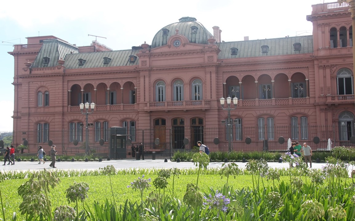
We then head to Mayo Square – the seat of the Executive Offices of the Government.When Buenos Aires was founded in 1580, this square was beside the River Plata, and the city grew south from there.Today, the square is faced by the famous Presidential Palace – the “pink” Palace! It was originally a “fort” that was pink because of it being “painted” with sand, clay and bull’s blood.This was one type of “paint” that would hold-up in the area’s high humidity.Ever since, the tradition of it remaining pink has endured.Also facing the square is the Cathedral (the home-church of the current Pope – Pope Francis), the Cabildo and a bank.The Cabildo served as the residences of important people born in Argentina during colonial times.In those times, a Spanish Colony needed four things to be recognized by Spain: 1) a Town Square, 2) a Fort, 3) a Church, 4) a Cabildo. The Presidential Palace today is only where the President of Argentina works, as he lives in the suburbs of town, and helicopter’s in to work. The Cabildo has been converted to a Museum and the bank sits on the site of what used to be the town’s original cemetery. One of the balconies of the Palace is where Evita famously spoke to the people of Argentina, and it was also the actual site where Madonna famously portrayed her and sang “Don’t Cry for Me, Argentina”, although Evita never said those words.
The Presidents Famous Pink Palace
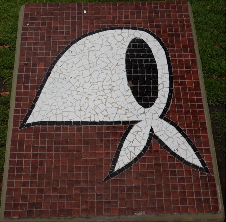
In the 1970’s, after President Peron had died, his Vice-President, Isabel, was overthrown by the military and a dictatorship ruled the country until after the Falkland’s War in 1982. During those year the dictatorship was in power, over 30,000 people went missing in the country, and many are presumed dead or killed by the regime. During those times, it was illegal for people to assemble in groups larger than 2 people, or to stand still in Plaza de Mayo, or to demonstrate.A group of mothers and grandmothers (the “Crying Grandmothers”), wanted to know what happened to their children who had disappeared and began assembling in Plaza de Mayo as individuals who would walk in a circle around the square, wearing white kerchiefs and holding pictures of their missing children. Today, they still assemble every Thursday at 3:30pm to continue the march and the search for the truth.Many of these missing individuals were pregnant women who were killed, and their babies given by the dictatorship to families in Spain as favors. As of today, only 140 of these missing children have been found through DNA testing.
May 25 1810 Revolution Memorial
White Kerchiefs of Crying Grandmothers Org
We then went to the London City Coffee House, a favorite haunt of author Arthur Julio Frenencio Cortazar who would write his novels here, to meet and talk with one of these “found children”. Diego was 42 years old, married with two children, living in Miami, but working between Miami and Buenos Aires. His birth mother and father went missing when his mother was 8 months pregnant in 1976, and he was an adopted son of a couple in Spain. His adopted father told him that he was “purchased” in Spain because they desperately wanted a child.After his adopted parents were deceased, Diego went to the “Crying Grandmothers Organization” and was tested and discovered that his 93-year-old grandmother, Delia, was still alive and still looking for him.When he met his Grandmother, she told him how men had come in the middle of the night and took his parents from their home but left his 3-year-old sister asleep on the sofa, whom his grandmother had then raised.Unfortunately, his sister had passed away just the year before and so he could never meet her.His parents were likely beaten and tortured, killed and dumped in the river, like so many others whose unidentified bodies had washed up. His grandmother was one of the original 12 founders of the organization and she had vowed to never give up.Today, he works with his grandmother to help find other missing grandchildren – babies of women taken while pregnant – there are still 370 of them missing!Many believe that the trade in babies was a secondary business of the dictatorship, used to generate income and to trade for favors with high-ranking supporters in Spain and elsewhere in the world.When the dictatorship ended in 1983, the newly elected government put all the dictatorship’s leaders on trial for these crimes, and after a short reprieve, most are still in prison today.
After tea and our conversation with Daniel, we headed down into the Buenos Aires subway which was first line built in 1903 and was one of only 5 in the world at that time. The original subway cars were wooden and were originally built in Belgium in 1903. The subway started with the use of token, which continued until the car were finally replaced in 2013!The new replacement cars are from China and tradition dictated that each train route is color-coded, along with the stations and the trains. This was done to accommodate the large immigrate population in Buenos Aires who could not read.Even today, the subway costs only ~50 cents. Leaving the subway, we reboarded our bus and headed south into La Boca!
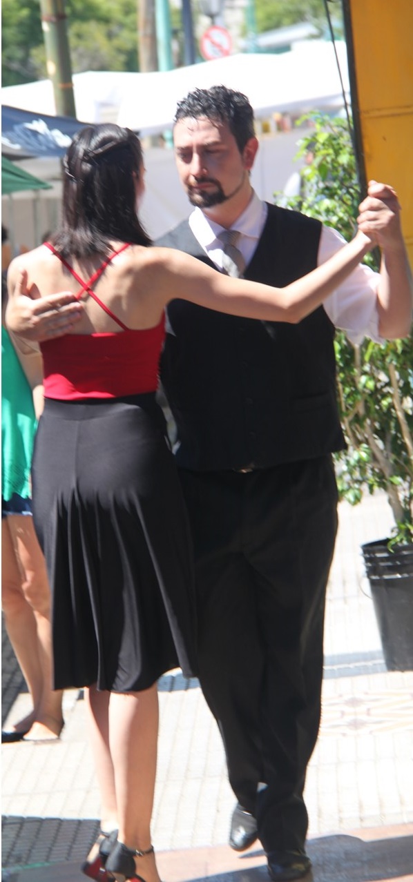
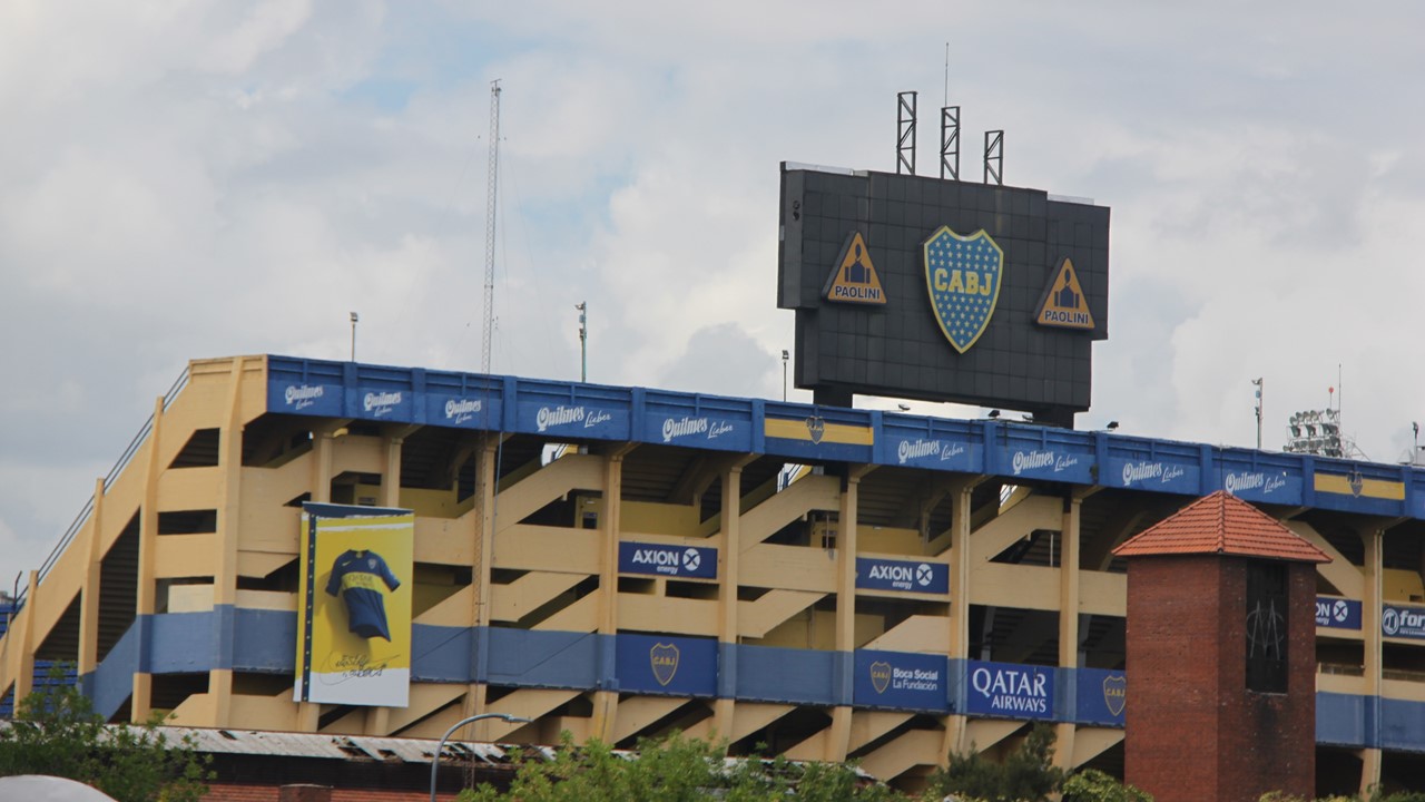
Originally, the city of Buenos Aires has grown south towards the mouth of the river, (La Boca means “The Mouth”), which is relatively shallow (<20 ft.), but is up to 150 miles wide.Rumor has it that it was named “River Plata” (Silver River) to lure the many treasure seekers to the area, and the area grew modestly in the 1600’s and 1700’s. However, when the great Yellow Fever plague of 1871 hit the city, all the affluent people moved north, and the Boca area was reclaimed by immigrant Italians, Polish, Spanish, etc.The old houses we repaired with old tin and scraps from the port and ships and painted in whatever leftover paint could be gotten at the docks.What resulted was a colorful melting pot of culture, art and music which gave birth to the Tango.Carlos Cabelle is the most famous of the Tango singers and is said to come from this area. This area is the home of La Boca Football Team (founder 1905) and their blue and yellow colors dominate the landscape.However, these were not always their colors, and history relates that they played a rival club for the rights to Argentinean colors – blue & white, with the loser having to take the colors of the next ship’s flag into port. La Boca lost and the first ship in was a Norwegian freighter.Today, their chief rival is from the northern part of town – River Plata Soccer Club whose colors are red and white.We visit the La Boca neighborhood, (La Caminita), only in the day, as recommended, and work our way through the tango dancers, artists, musicians, souvenir shops and restaurants.From here, we head back to the hotel passing a campus of the University of Buenos Aires.In Argentina, graduation from a public University requires hard work and good study habits, and the University of Buenos Aires is widely regarded as the best.It currently has ~350,000 students spread across all age groups and many campuses.It is here that we see players on horseback practicing an unusual national sport , Pato, played with a ball covered in handles which is thrown from player to player while riding.
La Caminita Neighborhood in La Boca
Tango Dances in La Caminita
La Boca Stadium – The Candy Box
Once democracy was re-established in Argentina in 1983, the country began a cycle of turbulent political and financial crises, which some people finding their savings devalued to half overnight.In fact, during this time, Argentina once had 5 different presidents during a single week.Currently, Argentina is suffering another financial problem with rampant inflation eroding the buying power of its citizens and the country falling deeper into debt. The average income for an Argentinean worker today is only ~$600 USD per month, and the minimum wage is set at ~$250 USD per month.
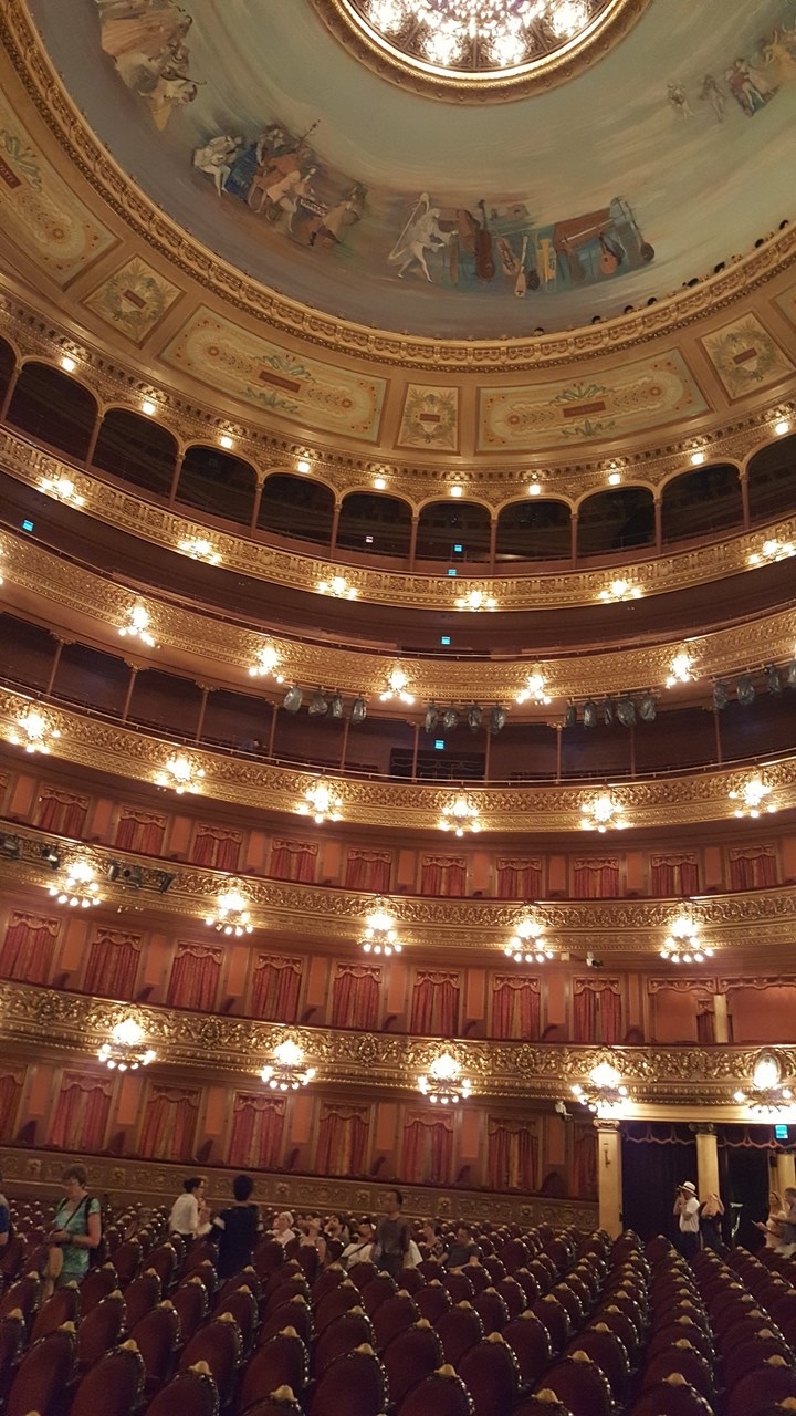
Upon returning to the hotel, we left for a walk back to the Teatro Colon – the Opera House – for our previously purchased tour. The Teatro Colon was built in 1908, with the best acoustic design possible, and with newly available electricity for lights. It was fully cleaned & restored in 2006-2010.Today, everything in the Opera House is still original, including the different marble foyers and stairways, the art and the French gallery furniture.Busts of musicians look down from above the hallways and one enters the ~3000 person, (400 standing), theater.There is a full orchestra pit with a huge stage – the theater is 20 meters high with 9 decks and 3 underground floors.Even today, no amplification or microphones are needed for the performances on stage because the acoustics are so good.
The Teatro Colon Opera
After our tour, we returned to the hotel to get ready for dinner hosted by a local couple for 5 of us. Monica and Roberto are a retired couple living a short 10 minutes away by bus.Their flat is located up 6 floors via elevator and is a roomy 3-bedroom condominium (with a balcony) which they purchased in 1995, and where they raised their 5 children for at least a few years.Roberto was a foreign diplomat (economics) in Germany 3 times and in Brazil.Today, their 5 children are located in California (2), Germany (2) and Brazil.We talked about economics, politics, retirements and the “younger generation”, (of course)!For dinner, we had wine, a posada casserole, (a common dish in Argentina), and a beautiful salad of greens, nuts & fruit with a home-made dressing.For dessert we had a flan with cheese, quince and honey, before saying our “good-byes” and ending our wonderful evening.
The next morning, we left for an early domestic flight to Ushuaia, the southern-most town in the world!On the way to the airport, our driver played us Madonna’s “Don’t Cry for Me, Argentina”, but we would soon return. After our adventures in Terra del Fuego and Torres del Paine, we would fly back to Buenos Aires from El Calafate, Argentina to extend our adventures in this city.
Upon our return on Friday, January 25th, we check back into our same hotel and have a little time to do some final shopping at nearby “Galleria Pacifico” a huge 4-level shopping mall immaculately decorated inside, and housing spectacular ceiling murals.In is located on our hotel’s street and adjacent to the popular pedestrian-only street – Florida Street – a 12-block-long hub of commercial activity and shopping.That night, we meet for our Farewell Dinner, held back at the old Puerto Madero waterfront at a restaurant called “Estilo Campo”, located just down the street from the restaurant we ate at the last time we were here.. Dinner is ribeye Argentinean steak with 2 different sauces, following a “warm-up” with beef empanadas, salad and fries, and followed by wine, ice cream and coffee.
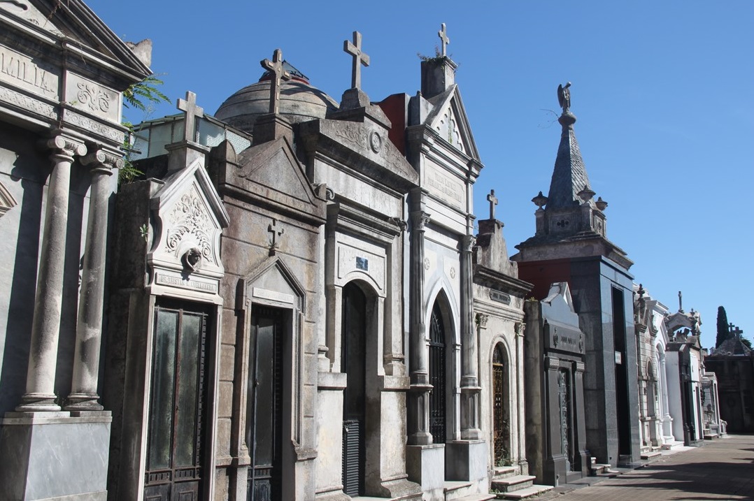
The next morning, we go in search of coffee at one of the many Starbucks in town, only to discover that they are closed until 9:00am in this part of the world.After settling for hotel coffee, we meet our local guide, Cynthia, again, to continue our exploration of the city.Our first stop is slightly north of our hotel in an area called “The Recolleta”.This was a high-class, more expensive part of the city that was built during the “high times” after World War I when Buenos Aires was known as the “Paris of the Americas”. It includes a mix of French, Italian and Spanish architecture, and centered around a Religious Monastery & Nunnery and their Catholic Cemetery originally founded on the outskirts of town in 1732.The Recolleta Cemetery eventually became a “showplace in death” where wealthy people build more and more extravagant mausoleums. Eventually, many of Argentina’s most famous people were buried here, where the space is now all accounted for, and one can only purchase an existing mausoleum.Originally, purchase prices were in the $300-600 USD range, but these have now escalated to ~$60,000 USD, (~$3000+ per sq. meter). Purchase comes with rules and with a ~$3500 USD charge for maintenance per year.Many of the Family Mausoleums have 25-45 bodies entombed there. If the maintenance is not paid, the mausoleum will fall into disrepair, but cannot be sold unless the previous owning family specifically agrees. Today, it is 12-15 acres big and is famous for the spectacular mausoleum architecture, elaborate crypts and their decorations.Also, although there is still the occasional burial there, most Argentineans today prefer cremation.
Recolleta Cemetery
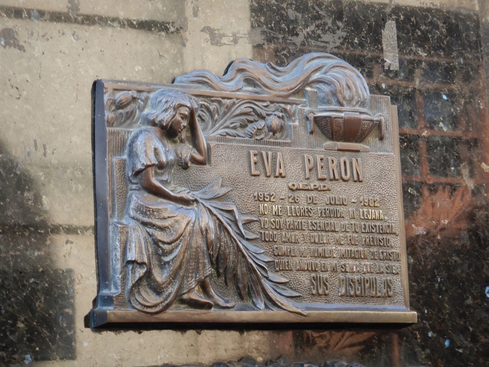
Eva Perons Crypt in Recolleta
Eva Peron is buried here in her family tomb, along with her sisters, brother and relatives. Eva was born Eva Duarte and was one of 5 children.Her father died when she was only 7, and her mother opened a little hotel and worked hard to support her family.At 17, Eva wanted to be actress, and for the next nearly-10 years found occasional work as a cover.In those days, she was considered very beautiful and she began to take on a role as a radio personality.She met Juan Peron at a festival after his first wife had died of ovarian cancer. They lived together for some time, and then got married.When her husband was elected President of the country’s new Socialist Government in 1946, she took an active role as first lady opening foundations and donating monies and goods to the working-class people in her country, and around the world.She supported building schools and the Peron Government helped redistribute wealth from the Upper-Classes to the Lower-Classes. However, she died soon after of cervical cancer, but not before giving her famous speeches to the people from the Pink Palace balcony.She was only 33 years old!Her body was embalmed and her funeral lasted 44 days, (the country ran out of flowers), and she was displayed in a crystal casket so her people could see her.However, her casket and body soon disappeared and was “lost” for 18 years.Eventually, her body was returned to Argentina, kept at Juan and Isabel’s home for quite some time, until she was finally entombed in the family crypt. Juan Peron’s policies did not sit well with many powerful people in the country and around the world, and his Government was deposed by a violent coup in 1955 and Peron fled the country.In 1973, when the country was ready to have democratic elections again, Juan Peron returned with his 3rd wife, and was elected a second time, with his wife as his Vice-President.However, he died soon after in 1974 and his wife, Isabel, assumed the presidency supporting a more fascist group.This led to more social unrest and a military coup in 1976 which crippled the country economically, removed most social and political freedoms, and gave rise to a very dark period in Argentina’s history until after the Falkland’s was in 1982.When democracy returned in 1983, Argentina took 20 years and seven presidents to did themselves out of economic ruin and social instability.The 1980’s and 1990’s were filled with corruption, protests and economic problems.In 2001, the Government devalued their peso currency by 40% overnight! However, all that changed in 2002 when President Kirchner, a Peronist, stabilized the country’s economy, (voting in presidential elections is mandatory in Argentina).In 2007 he forfeited his presidency to his wife, Cristina, who suffered a 129-day strike by farmers and agricultural unions in 2008, but increasingly grew support for herself, especially after the death of her husband in 2010. Today, Argentina struggles with inflation, (50% in 2018), but maintains a positive outlook and is welcoming a growing Tourist Industry, (second-largest part of the economy).
Leaving Recolleta Cemetery, we head back towards town center along Avenue del Libertador and Avenue Alvear, the avenue of the wealthy during the 1920’s, (from 1880-1930, Argentina was the 8th largest economy in the world).Many homes here are huge and built with imported European materials and with European architects.However, the stock market crash of 1929 wiped out many of the wealthy citizens holdings, and the following depression forced the sale of most of these mansions – in many cases to foreign governments.Today, they serve as the Embassies of many foreign countries having been maintained and restored, and in wonderful, near-original condition.
Next, we went to the area of town referred to as “Little Palermo” – an historic neighborhood with large gardens, a planetarium, Japanese gardens, rose gardens, a jogging track, a large fitness club and the beautiful Palermo racetrack and restaurant. Buenos Aires is a city whose center is home to 3-million people and consists of 48 distinct neighborhoods covering 80 square-miles.The Buenos Aires area covers over 2000 square-miles, consists politically of 15 districts with a total of 9-million people.
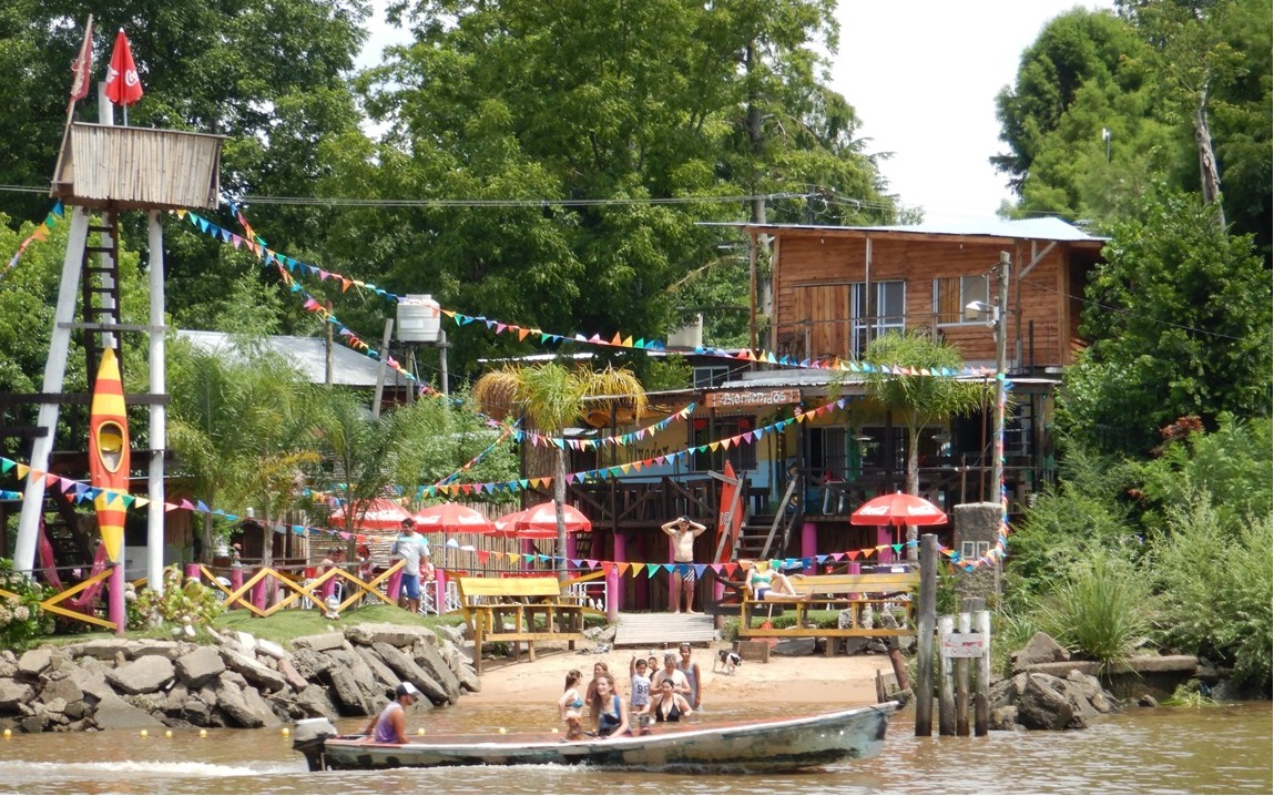
Next, we head ~20-miles to the far-north of the city to the area of El Tigre – a deltaic area on the river made up of thousands of islands and historically the location of weekend and summer camps and houses for people of the city to escape to.The area is named for the jaguars that used to roam the area and encompasses 3 provinces and an area as large as The Netherlands.Today, it is a mixture of camps and gated-communities and the country’s capital for rowing and kayaking. Here we take a Tigre Delta boat ride for an hour around a number of islands, (the water is only ~12-feet deep), drinking coffee and eating aljafors (2 soft biscuits with cream in the middle).After the boat tour and a quick lunch, we head back to the hotel to collect our belongings and head to the airport to take our flight home.
El Tigre District – Venice of the South
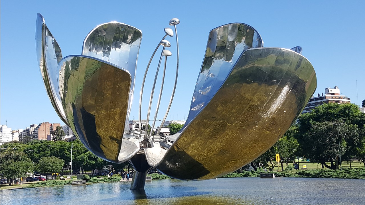
It is now Wednesday February 6 and we are returning to Buenos Aires after only ~2-weeks to begin our trip to Antarctica.We arrive in Buenos Aires on a domestic flight from the Argentinean side of Iguazu Falls, and take a bus from the airport to our hotel, The Emperador, located in the Recolletta area of the city.After checking in we decided to explore a few of the nearby parks which we had seen from the bus on our earlier visit here. We walked to Parc de la Flor to see an Architectural wonder, the Floralis Generica, a giant stainless-steel flower blossom that blooms every morning.It is a work from an Argentinian architect Eduardo Catalano that opened in 2002.At 23-meters high and 18 tons weight it was the first sculpture of movement in the country.It is a complex and precise high technology system that makes the petals (~3500 kg each) open with the first sunlight until its shape is complete, and then close again at sunset daily.
The Floralis Generica by Eduardo Catalano
We then had a welcome dinner at the hotel to meet our group that would travel to Antarctica with us.There are 10 of us plus our guide. Marco.Marco is from Chile and has been a guide for 25+ years and has been doing tours to Antarctica for 11 years, although this will be only his second time to the South Georgian Islands. In our travel-group, there are 2 couples from Florida, and one couple each from Illinois, California, and Pennsylvania, and all appear to be very seasoned travelers.
On Thursday morning, after breakfast, we met our local city guide, Eileen, for her unique version of our city tour.She is from Northern Patagonia.We travel south down Avenue Alvear, past the Vatican and Brazilian Embassies to the district of San Telmo where we again visit the Plaza de Mayo and review the early history of the city.From there, it is back to Recolleta Cemetery, and then on to La Boca and their 55,000-seat soccer stadium (The “Candy Box”). (by the way, in order to prevent violence in the stadium, only the home team fans are allowed to attend games in Argentina).After visiting La Caminita again, we travel by bus through the northeast side of Puerto Madero where there are many avenues and parks dedicated to Women and their leaders.
After returning to the hotel, and taking a stroll back to Galleria Pacifico, we were off to Seraphin for lunch, a small local restaurant across from the park in the Recolleta area for pizza and wine – an awesome little local place filled with locals.We then walked back to the Recolleta Art Museum that gets its walls repainted every 2 months with a new mural. We then strolled down Avenue Alvear looking at all the gorgeous mansions that have now been turned into embassies, before making a stop at the Post Office for stamps, on to the grocery for wine, and back to the hotel to pack.The next morning, we fly to Ushuaia to board the M.S. Fram, our Expedition ship to Antarctica.
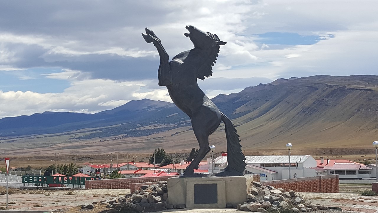
On Monday morning, January 21st, after a wonderful buffet breakfast, we left Puerto Natales on our bus to continue our trip north to Torres del Paine National Park in Chile.In 2-hours, we reach a small town at a crossroads called Cerro dos Castillo’s.This little town has a nice cafeteria and store, and sits right at the border with Argentina, but today, we are continuing north in Chile.After a quick bathroom break and a bit of souvenir shopping, we continue our trip north. The countryside is dry and wind-swept, consisting only of dry, small grasses and small hardy bushes.Here, the principal industry is ranching with lamb for wool and food, and cattle.Sheep herds are plentiful in the countryside, as is beef, but everything else that the people here need – fruit, vegetables, medicine, etc. must be brought in via ships and ferries that make their way up the fiords from the north.These same ships then take the beef, lamb and wool from the processing plants back to the coast to be shipped around South America and the world.We pass a small village near the “Waters of Last Hope” Fiord where our local guide, Kris, lives with her boyfriend and dog in a very modest house with no running water, and with propane to cook, wood to heat and rationed electricity. She moved here because she enjoys the outdoors, and the government paid her to build a house as part of a program to get people to move to this sparsely populated area.Her 1-acre property cost $10,000 USD 8-years ago, but now is worth nearly 8-times that because of a huge land-grab being driven by tourism. The “Waters of Last Hope” Fiord was named so because it was “the last hope” (unsuccessfully) during the area’s early exploration to find another waterway across Patagonia. Today, the town is growing, and things are changing rapidly.Before this past year, the nearest hospital was in Punta Arenas – over 3-hours away by car!This drove the locals to cross the border and use the Argentinean hospital instead – less than 1-hour away!Today, they have a new hospital in Puerto Natales which is much closer.
Hotel in Puerto Natales
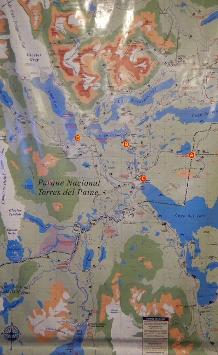
Map of Torres del Paine National Park in Chile
Since the primary industry of the area is ranching (and now, tourism), the region is dominated by very large Estancias (ranches) raising either sheep, or Hereford or Angus cattle – no milk cows. Small ranches are ~8000-10,000 acres, and large ranches can be over 200,000 acres. The sheep are Corridales from the Falkland Islands, and are of Scottish origin. Alpaca were once tried to be raised in the area, but those efforts were unsuccessful.The region also hosts a large number of rhea’s (smaller ostrich-like flightless birds), guanaco’s (a llama-like animal), and herds of wild horses and wild pigs that still roam the countryside.Watching over all of these animals are a significant number of pumas roaming the range, and, in the higher altitudes, a large number of condors that soar overhead watching and waiting for an easy meal.
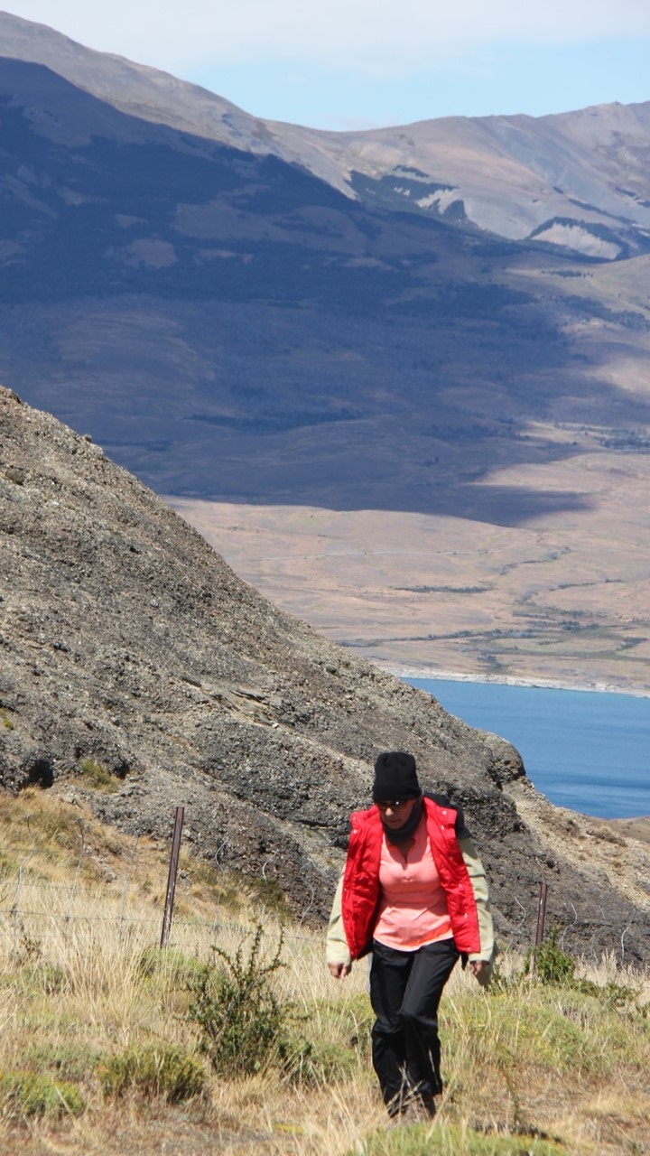
Julie on Hike in Torres del Paine National Park
We finally arrive at the Lake Sarmiento Entrance to the Torres del Paine Park, where we check in and pay our park fees, and immediately begin our first hike.We hike ~4-miles from the ranger’s station, up a hill to a number of lookout views of the Paine Massif and of the “Towers”, and to the lookout at Laguna Amarga, passing along the way various guanaco’s who paid little attention to us, However, we were warned not to get too close, as they spit much like their distant-relatives – the camel.All along the hike, we faced 35 mph headwinds and occasional rain, but the brief periods of sunshine and the views made the hike so worthwhile.After our hike, we took a short drive to Nordenskjold Lookout where we ate lunch in the bus while facing growing winds outdoors, before exiting to take in the view.Then, we traveled north to Salto Grande Lookout to look at one of the more famous waterfalls in the park.Once arriving, we took a short, 15-minute walk into 60-65 mph wind gusts that made any walking difficult, but finally made it to the small boardwalk for pictures and the view.Finally, we traveled south a bit to Pehoe Lookout to look over Lake Pehoe. By now, the winds had abated, somewhat, and from here we had a good view of the local hostel which was located on an island in the lake accessible by pedestrian bridge only. Some of the area had been devastated by forest fires – nearly all of them started by man – and there were large areas with whitened, lifeless tree trunks and only small shrubs. In response, all along the lake, over 200,000 beech trees were planted two years ago and hopefully they will form the basis of a future forest. We then traveled to our hotel, the Rio Serrano – one of the few hotels within the park – where the rooms and the lobby were lined with glass allowing an overlook of the nearby plain and “the Three Horns”and “Towers” Mountains that rose into the clouds not far away. After checking in, we take a swim and sauna in the spectacular indoor pool, before meeting as a group for a buffet dinner.
Young Guanaco watching us
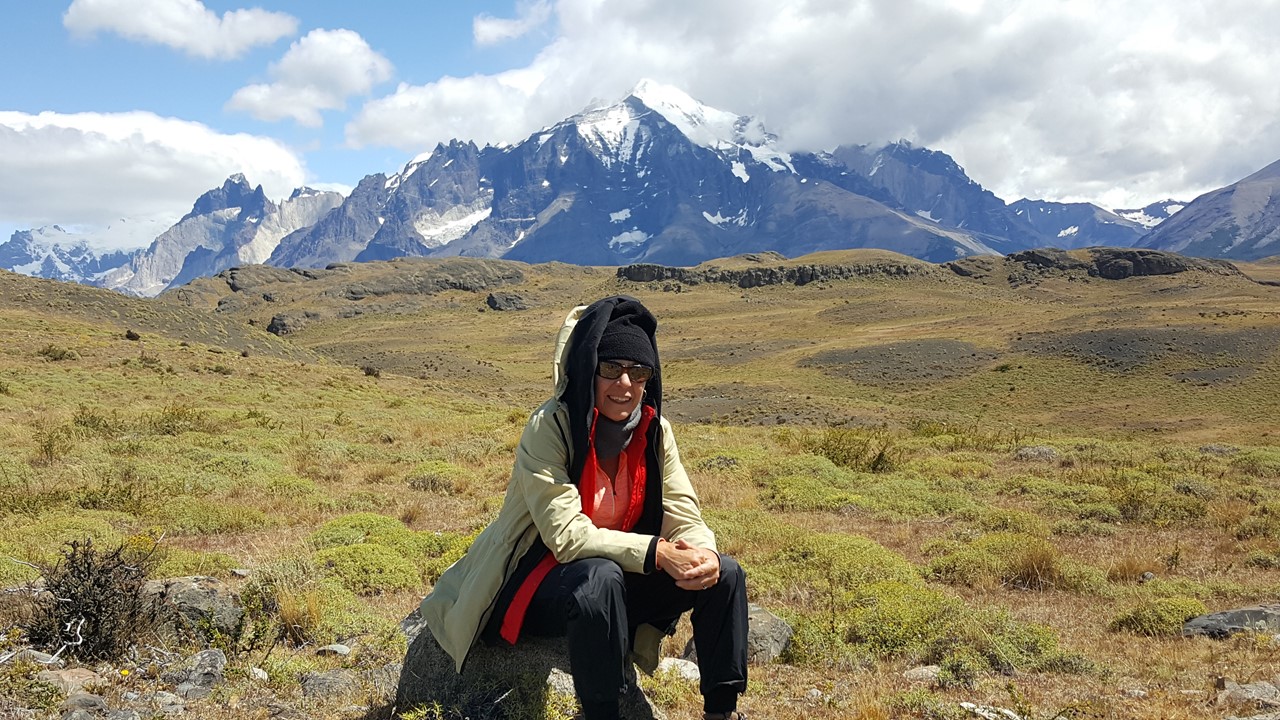
Resting in front of the Paine Massif
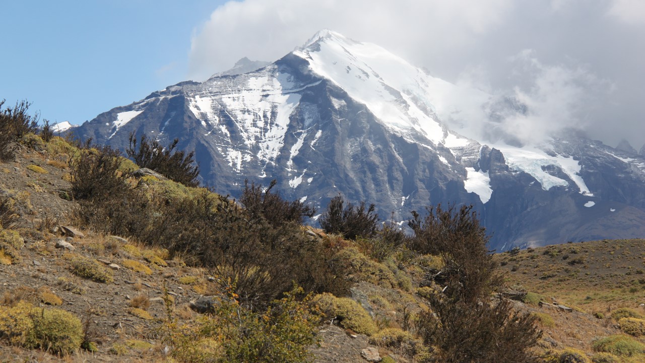
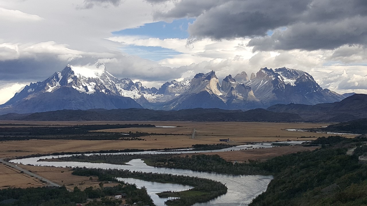
View of the Paine Massif
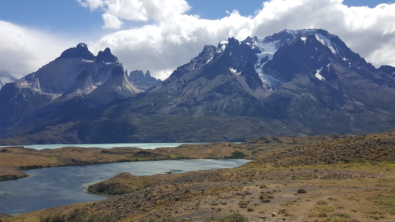
Pehoe Rivers in Torres del Paine National Park
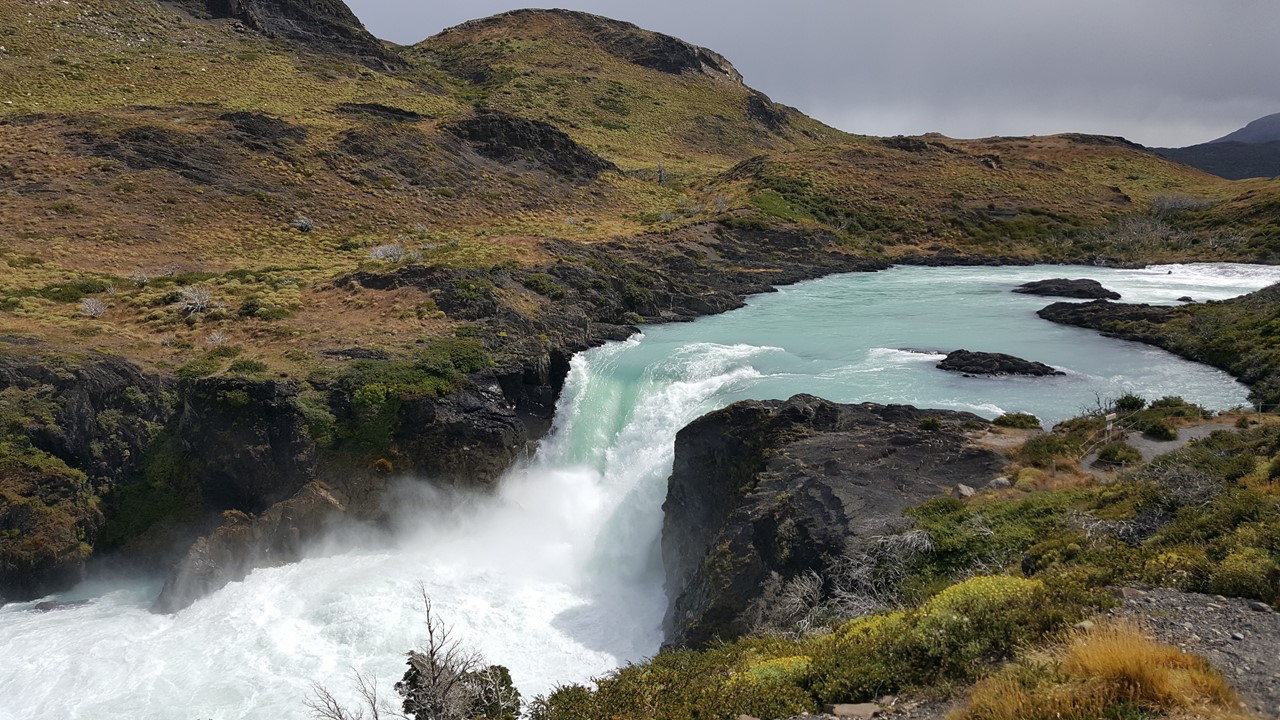
Waterfall at Salto Grande Lookout
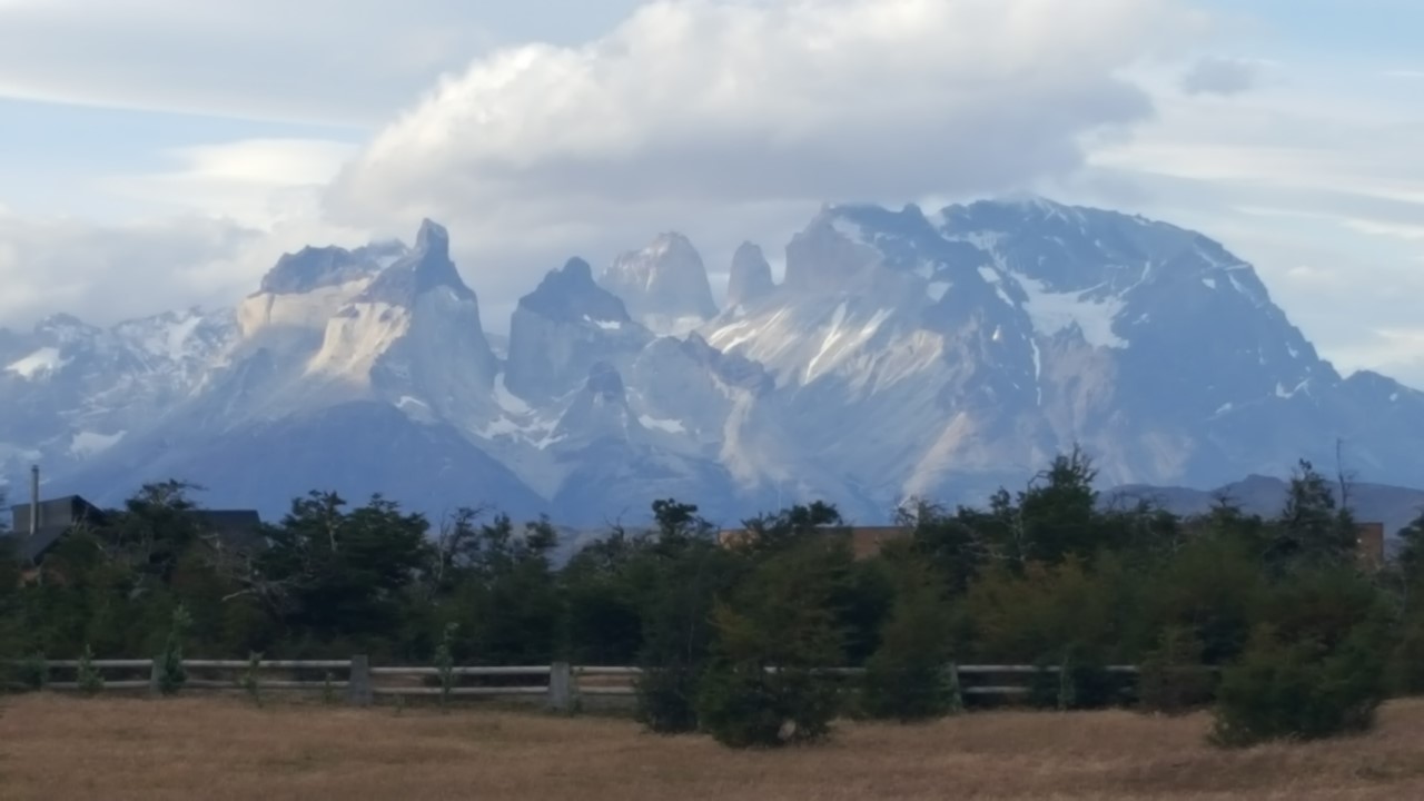
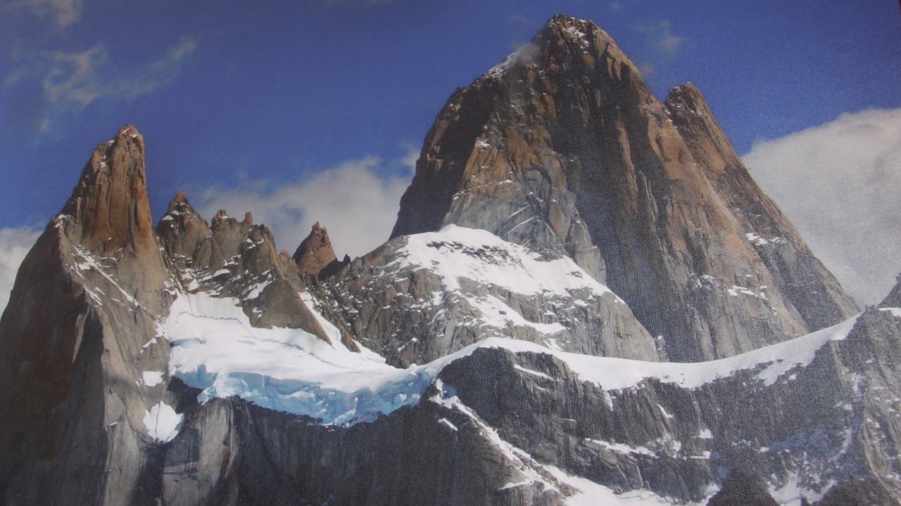
The Towers and Horns of the Paine Massif
View from the Rio Sorrento Hotel
Impressive View of the Towers
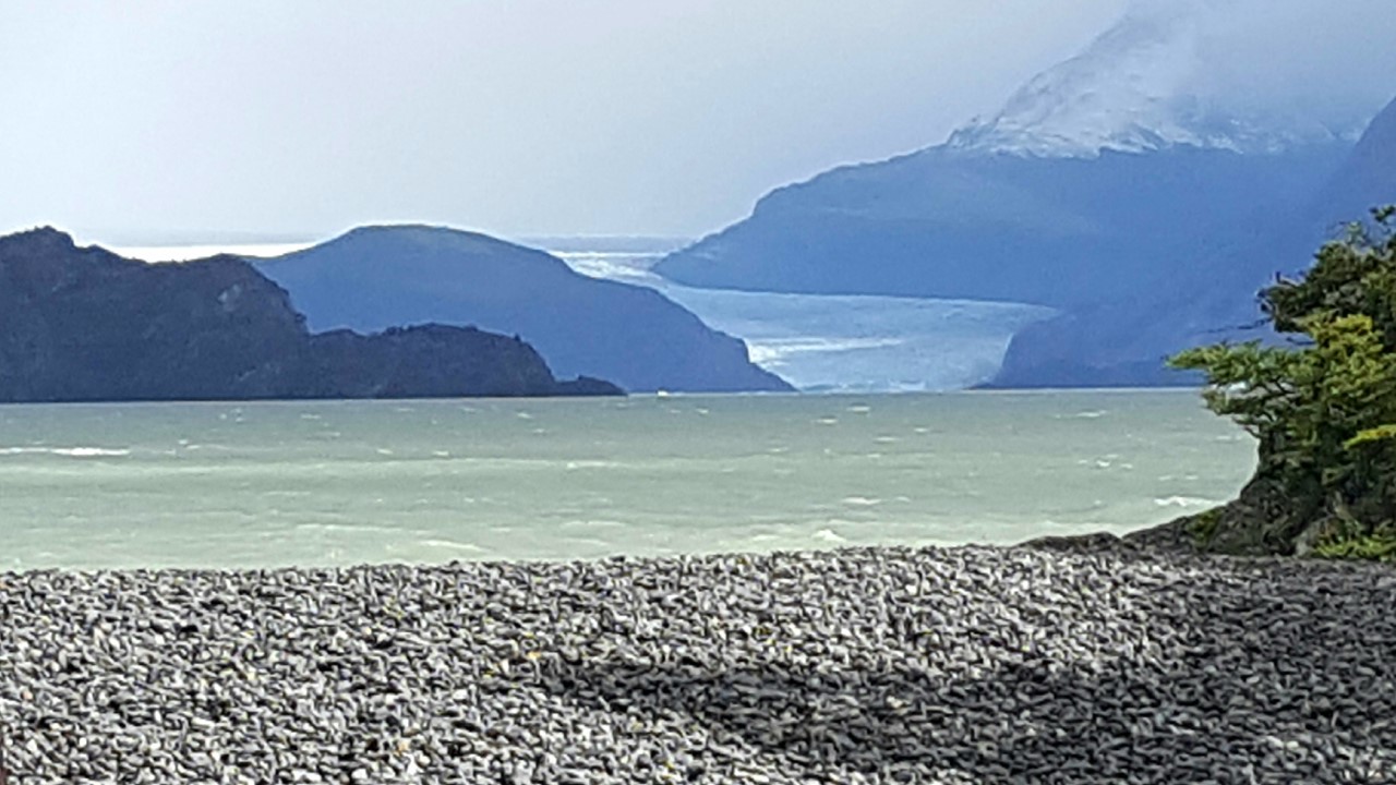
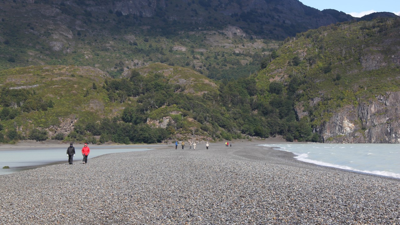
The next morning, we are greeted with a beautiful rainbow at breakfast before we set off to hike to a view of Grey Glacier.The park’s glaciers are in significant retreat, and Grey Glacier is disappearing at a rate of 56’ per year for the last 70 years!Grey Glacier and Grey River were named for an early Swedish explorer that spend time describing the area.We drove to the southern end of the Glacier’s lake where we began our hike through arctic forests, across the Grey River on a rope bridge, and then 1-mile across the glacier’s 400-year-old terminal moraine which stretches to an island lookout point.After climbing up a rocky trail to the island’s viewpoint, one could watch the icebergs float by and catch a glimpse of the mile-long dual faces of the Grey Glacier.Although our hike began in the rain, and we crossed the moraine in gusting winds, when we arrived at the lookout the skies cleared, and we were greeted with gracious sunshine.Because of the weather, we encountered no one else on our journey there, but passed a huge number of tourists beginning their hike on our way back.
View of Grey Glacier from Ancient Terminal Moraine
Icebergs from Grey Glacier
Crossing the Mile-long Terminal Moraine
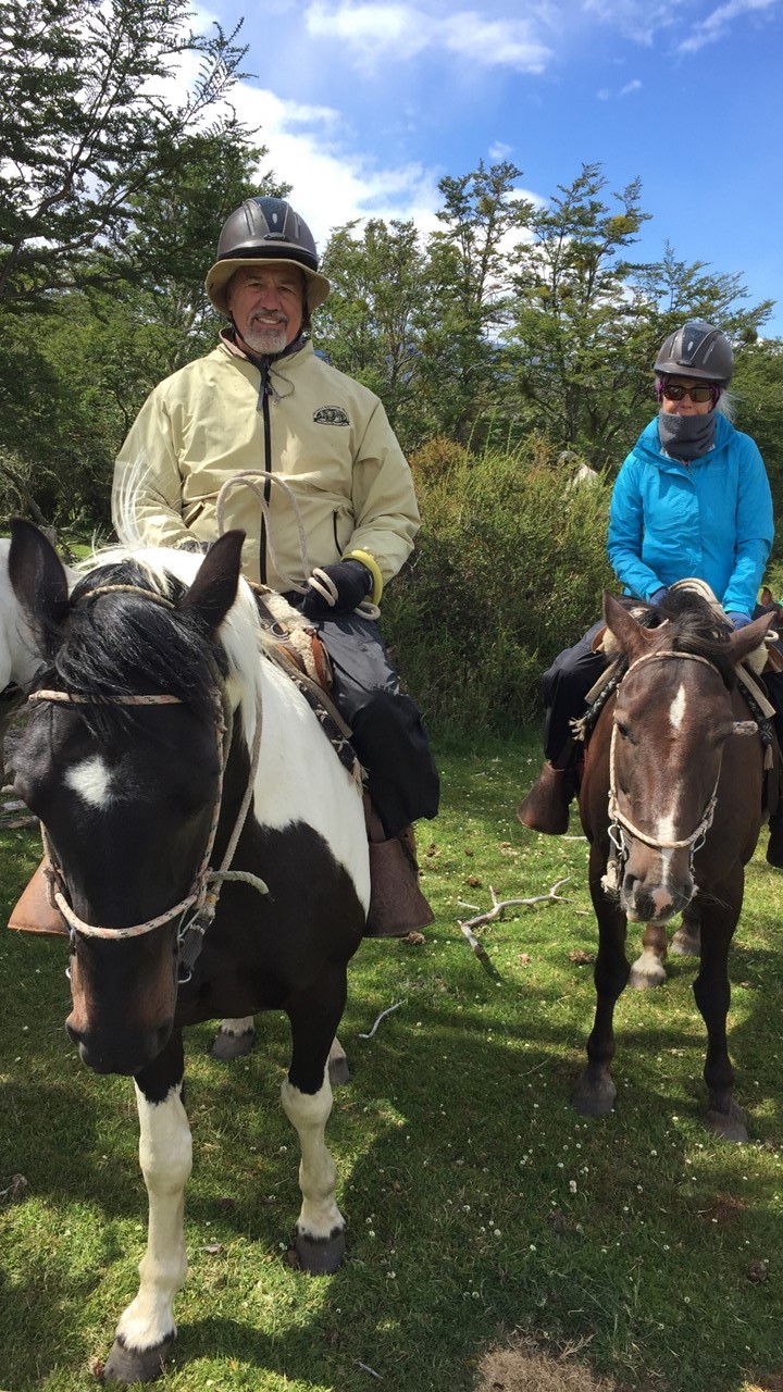
We arrive back at the hotel in time for lunch, and then it was time to go horseback riding.Only 8 of decided to participate, and we met our guides at the stables, got introduced to our horses, and began our ride.Unfortunately, about 40 minutes into our ride across the plains and into the woods, the winds again picked up significantly, and we needed to head back.If the winds get too high, it can spook the horses, and can make sitting up on horseback unstable.Since we returned early, we decided to take a traditional “tea time”.Apparently, a very independent woman, Lady Florence Dixie, came to the area and began the tourism industry back in 1879.She was an accomplished hunter and developed a number of recipes for the widely available rhea of the time. While in the area and guiding others, she instituted tea time and it has remained a local area tradition ever since.Lady Florence Dixie eventually returned to England and while there wrote a hugely popular book called, “Across Patagonia“, that documents many of the details of living in the wilderness at that time. That night we have a dinner of fish with mushroom stuffing.
Horseback Riding in Torres del Paine Park
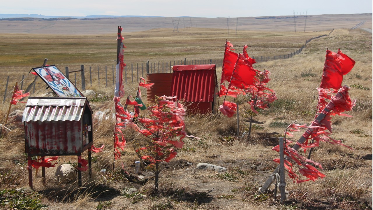
On Wednesday morning, we meet to quickly review our time from Puenta Arenas through Torres del Paine before returning to our bus to leave Chile.From here, we take the 2-hour bus ride back to the Cerro dos Castillo’s crossroads for the border crossing to Argentina.Along the way we pass Torres Lake, an area that looks green and lush with beech and cypress trees and populated with private estancias raising beef cattle.We arrive at the crossing at ~11:30am, in time for lunch taken upstairs above the gift shop.After lunch, we walked to the Chilean Border Crossing for passport control before reboarding the bus, crossing the border fence at the top of the hill, and then stopping at the Argentinean Passport Control & Customs Office on the other side.Here, we switch from a Chilean bus and driver to an Argentinean bus and driver and continued our journey.In Argentina, out in these desolate and open spaces, the side of the road will occasionally have red-decorated “shrines” dedicated to Gaucho Antonio Gil.Legend has it that if you stop at one of these shrines and leave something of high importance to you there, and fulfill a promise to Gaucho Antonio, that good “karma” will watch over you.This is very popular with many of the long-distance truck drivers in Argentina, and so we stopped and left various items, including a can of beer over the ground in front of the shrine.Apparently, our sacrifice worked, because we were immediately greeted with a Southern Crested Caracara falcon and had a smooth journey the rest of the way to El Calafate.
Entrance to Cerro dos Castillo Ranch
Gaucho Antonio Gil Shrine
At the Border with Chile and Argentina
We arrived in El Calafate around 6:00pm and checked into our hotel, the Kosten Aike, which was located only 4 blocks from the local bay, and only 2 blocks from the town’s Main Street.After an early dinner of Trout with Vegetables or Lamb Stew, we explored Main Street and the shops and brewhouses located there.
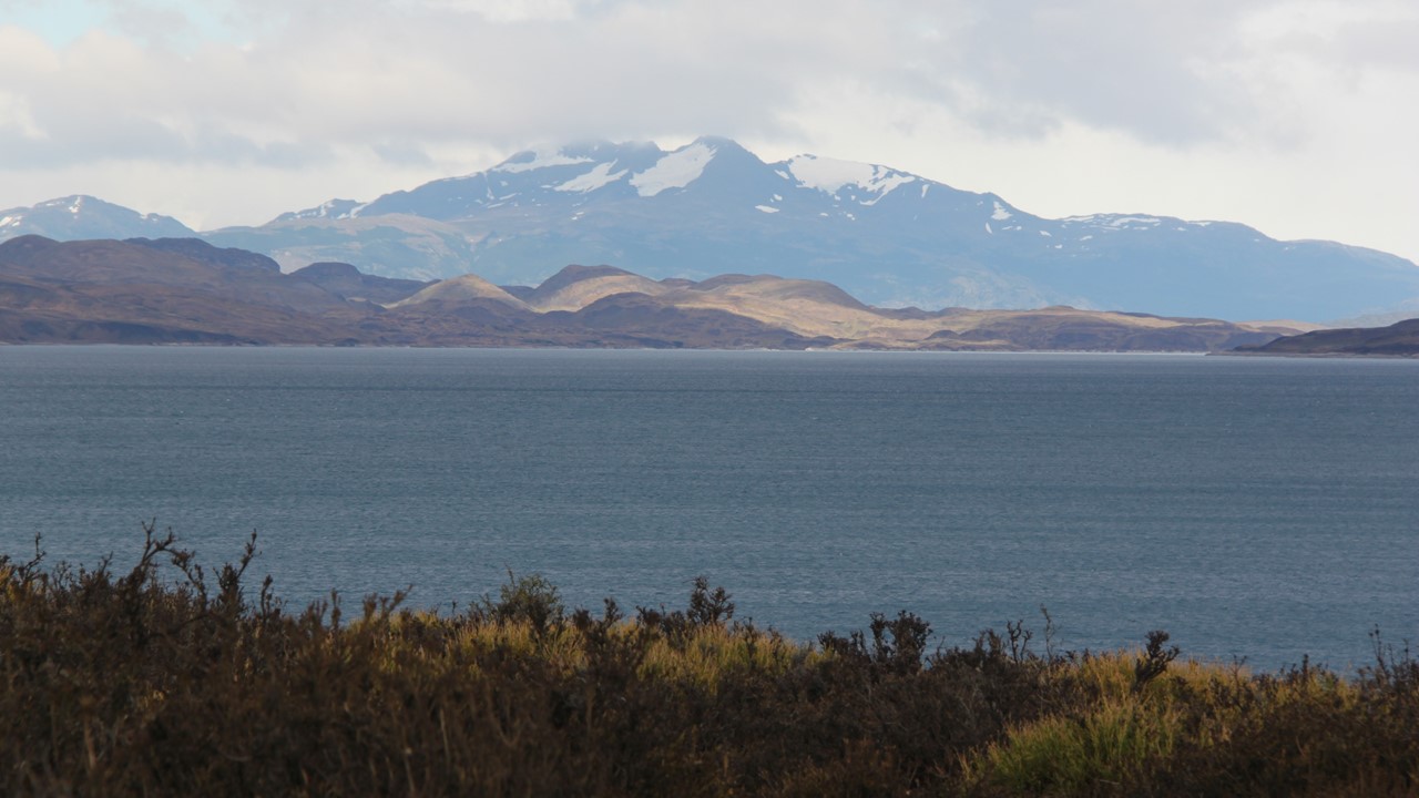
Thursday morning, we began our adventures driving along the bay-front, stopping to take pictures of the pink flamingoes and black- and white-headed swans that clustered in the area.The bay is a part of Lake Argentino, (first described & extensively explored by Fransisco Murino) a lake formed by the glacier waters coming from an enormous ice cap (the second largest continental ice field in the world – after Antarctica) and the heart of Los Glaciares National Park (over 50 glaciers). Unlike most glacier fields which typically form at altitudes above about 8200’, most of the glaciers of Los Glaciares form at around 5000’.Fransisco Murino was the country’s first recognized naturalist who was instrumental in preserving the local environment and is widely regarded as Argentina’s “Teddy Roosevelt”.
Lake Argentino
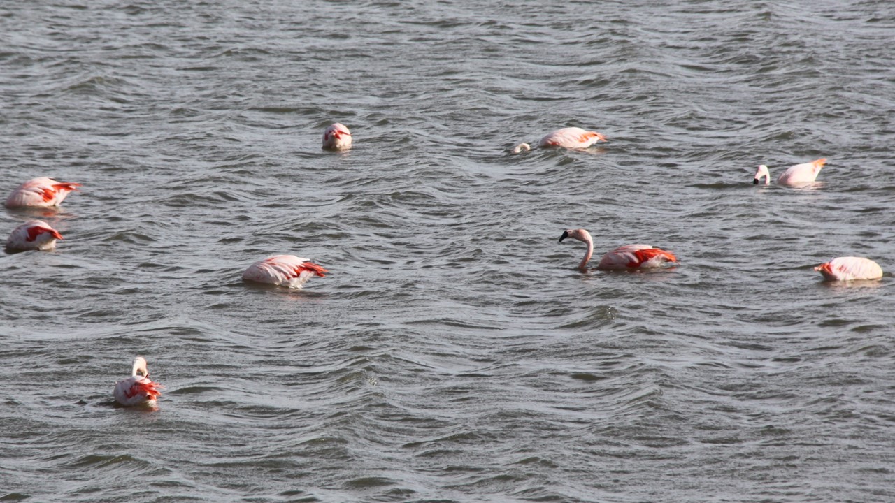
Flamingos at Lake Argentino at El Calafate
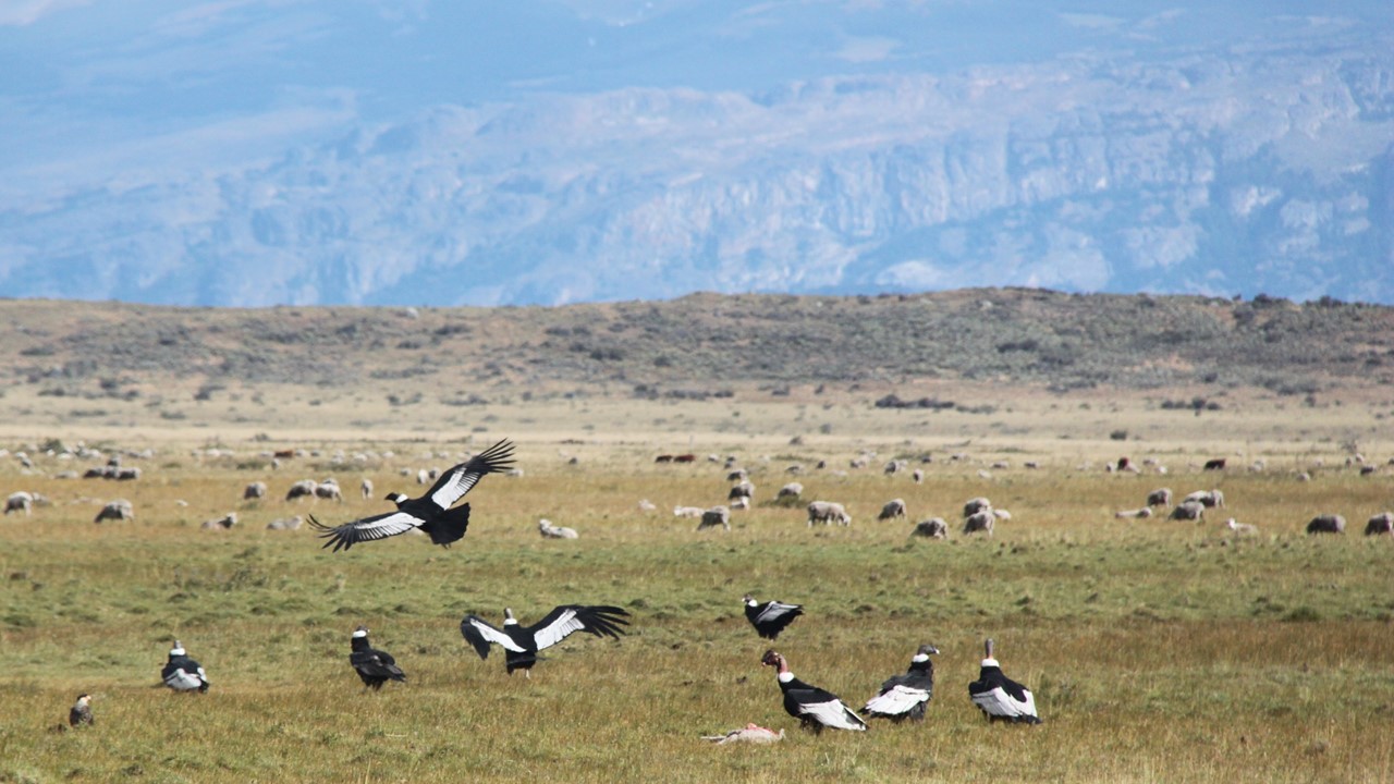
As we leave the town and lake behind, the air chills and dries, and the landscape is again brown, short grasses, and the vistas are endless.Local ridges are stained from the residence of numerous condors, and sheep, rheas and guanacos populate the landscape, along with skunks, moles and armadillos. This area is shielded from most rainfall by the Andes Mountain Range, and only receives 15” of precipitation per year. The only trees here are poplars that have planted by local ranchers as wind blocks, as they do well near water and creeks.With 100 miles to go, we can already see the higher reaches of the famous Perito Moreno Glacier which dominates this area and forms the basis for most of the town and region’s tourism. Along the way, we spotted eagles and condors overhead, but then we come upon a dozen condors on the ground feasting on a deceased lamb.Condors can live over 30 years old, and they raise their young in the nest for 2-3 years before they fledge and go on their own.
Condors Feasting on a Lamb
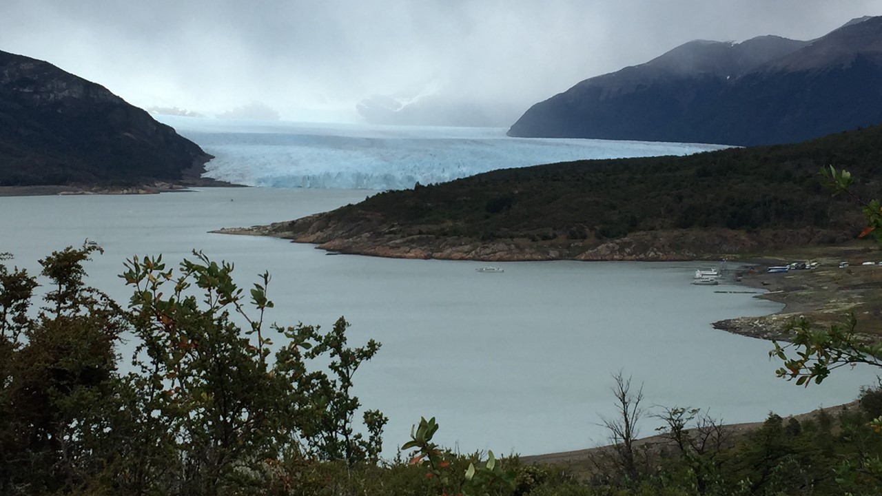
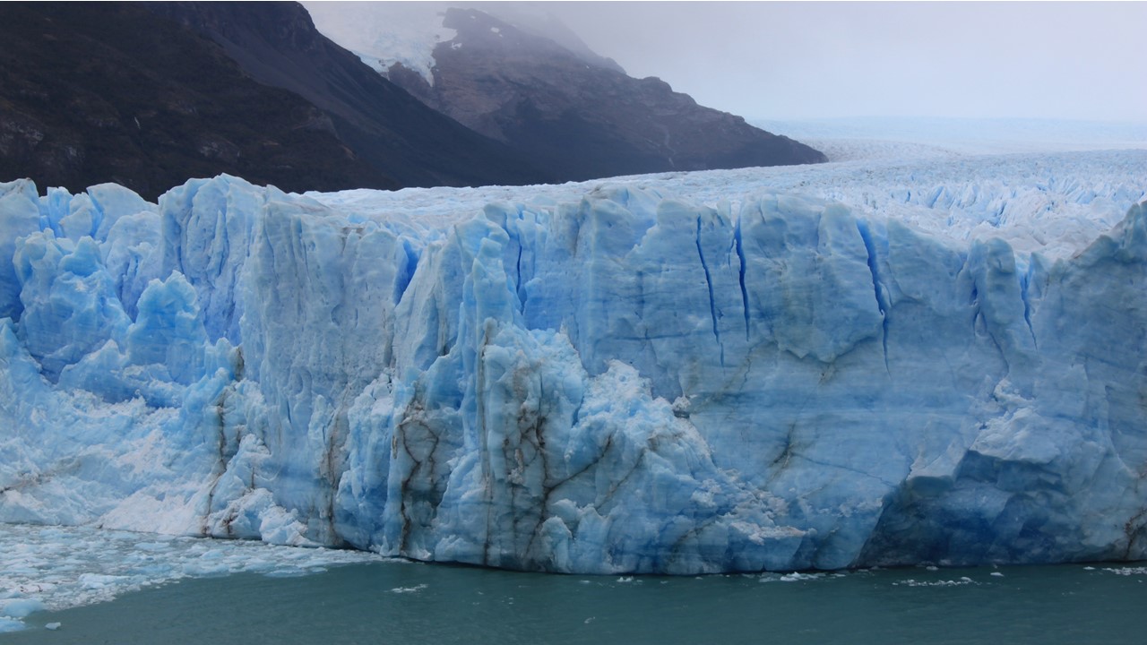
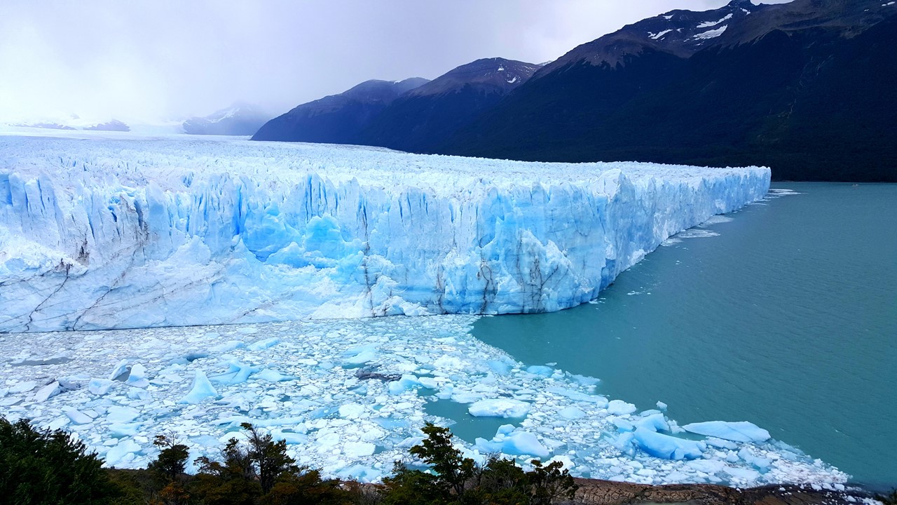
Soon we enter Los Glaciares National Park which was created in 1937 and is the second largest National Park in Argentina. Here is located Perito Moreno Glacier, towering over 200 feet above the Lake Argentino, and moving at 3-6 feet/day towards and into the lake. The glacier has been stably doing this since recorded times in the 1800’s, but no one knows if it is getting thinner, thicker and remaining stable upslope.The glacier’s face comes very close to a point of land that the park has used to install an extensive network of catwalk loops that are clearly labeled by color and that circle back and forth in front of the falling and extensive ice face, allowing one to view all aspects on the glacier.In fact, every few years, the glacier moves far enough to join the point of land, blocking the water flow from upstream into Lake Argentino.This causes the dammed water upstream to rise over 50’ higher before the dam breaks and a balance in restored. After exploring all the walkways, we grab a quick hot chocolate at the gift shop before returning to town for shopping and dinner on our own.We decided to “bar hop” and started at a local brewery pub listening to a hand-drummer before moving on to a lamb burger pub and finishing with nightcaps and then returning to the hotel.
Perito Moreno Glacier in the Distance
Perito Moreno Glacier at the Upstream End
Perito Moreno Glacier
Perito Moreno Glacier at Lake Argentino
On Friday morning (January 25th) we arose early and went for a long, early morning walk along the bay front looking at the flamingoes and swans before returning for showers, breakfast, and a final meeting to share our favorite highlights of the trip.Then, it was off to the airport for the flight back to Buenos Aires.The El Calafate airport is new (2005) and has significantly raised the tourism of the region.We board for our trip east, but our adventures were not over, yet!During the flight, one passenger had a medical emergency which required intervention and monitoring and medical evacuation upon our arrival.Luckily, she recovered fine, and the trip ended on a “high note”!
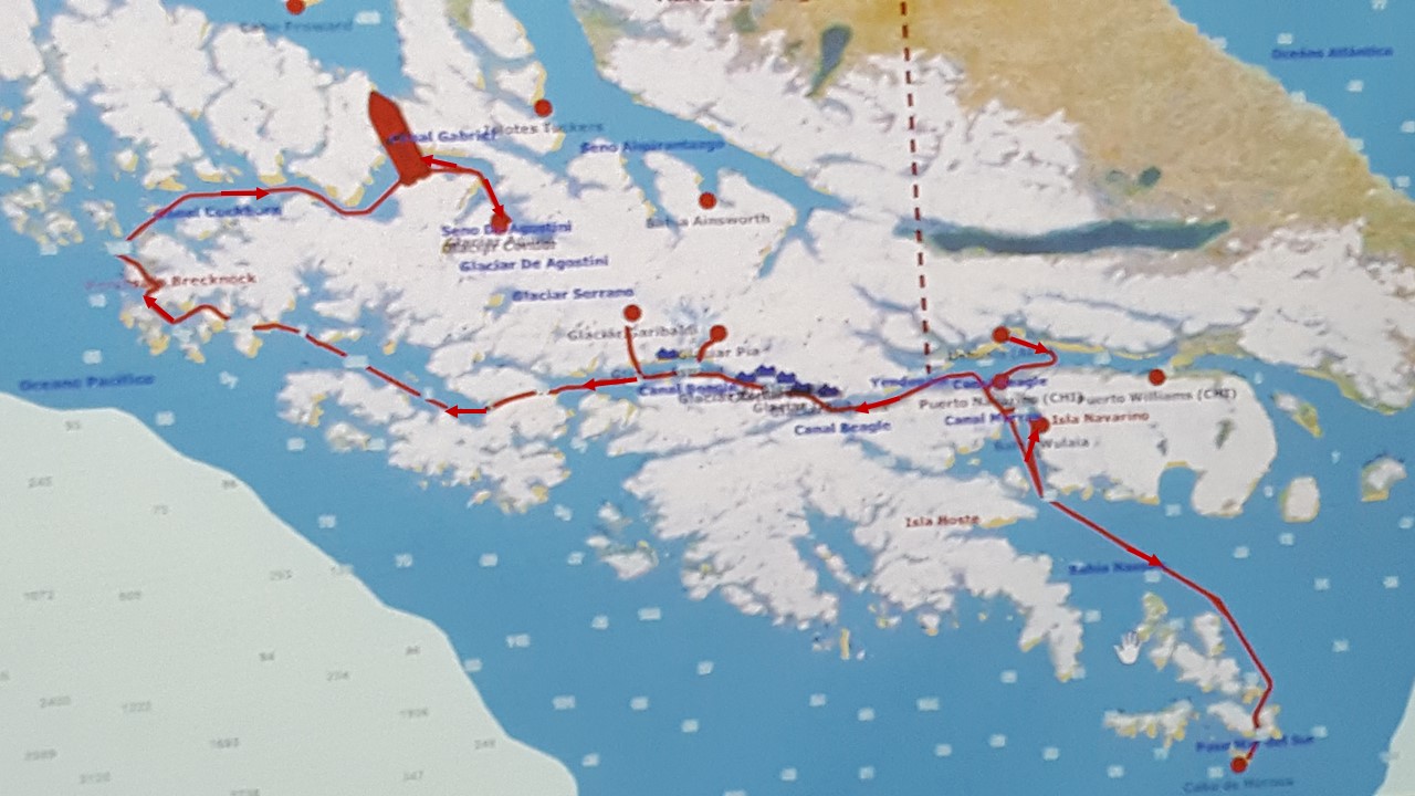
The southern tip of South America has long been shared between Argentina and Chile. The continent was originally divvied up between Spain and Portugal based upon an agreement along a particular longitudinal line that divided the North Atlantic. Unfortunately for Portugal, the line only happens to have cut through the eastern tip of Brazil, leaving the rest of the continent to be claimed by Spain. The south eastern part of the continent is dominated by a huge island named Tierra del Fuego – “Land of Fire”! The story goes that it was named such by Magellan as they searched for a way past the continent for a route to the Spice Islands of Asia.Tierra del Fuego was populated at the time by the Yamana people – a group of tribes that spent most of their time naked in their canoes searching for food.They would carry fire with them, and the observance of their fires in the dark gave rise to the island’s name.
Map of Fjord Route
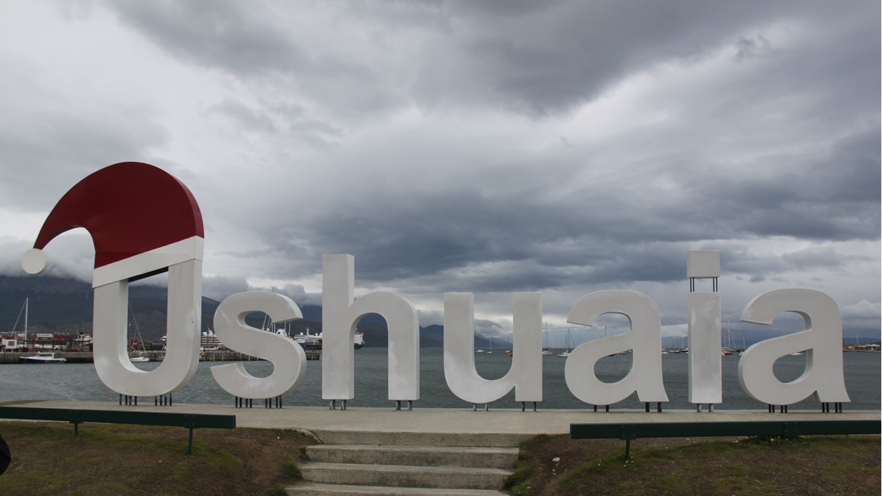
We flew south from Buenos Aires, Argentina to Ushuaia, Argentina – the southern most city in the world – located on the Beagle Channel – a more southern passage around South America than the famous, more northern, Straits of Magellan discovered earlier. After arriving at the airport, we walked briefly around town and got a local beer call a “Beagle”.The “Beagle” was the name of the ship that Charles Darwin was on with Captain Fitz Roy, when he visited the area in the 1800’s. The city’s name “Ushuaia” is Yamana for “Bay facing the sunset”, and the town sits nestled on the southern shore of the Tierra del Fuego island, just east of the dividing border with Chile, and on the channel that serves as the southern border with Chile. These borders were historically disputed between the two countries until the Pope intervened and set the agreed upon borders of today.
Ushuaia Town Welcoming Sign
The town originally served as a Spanish penal colony founded in 1902. Then President Peron closed the prison in 1942, and the old prison now serves as a set of museums. In those days, the prisoners survived on sparse ship deliveries, and whatever fish and sea lions that they could catch, and many of them stayed when the prison was closed.In this area south of the east-west Darwin Mountain Range, the winds are very strong and out of the west making all aspects of life difficult. Before the new airport was completed in modern times, airplanes would get pushed off into the channel from the old north-south runway.
After World War II, the town was a key base for the Argentine Navy.The Military Dictatorship in the 1980’s was struggling with a great deal of protests and unhappiness of the Argentine people, and in 1982 demanded that Great Britain cede the Falkland Islands to Argentina. Although long-claimed by Argentina as “The Malvinas”, the British had colonized the Falkland Islands and had supported them continuously. The British refusal resulted in Argentina declaring war on Britain in April 1982.
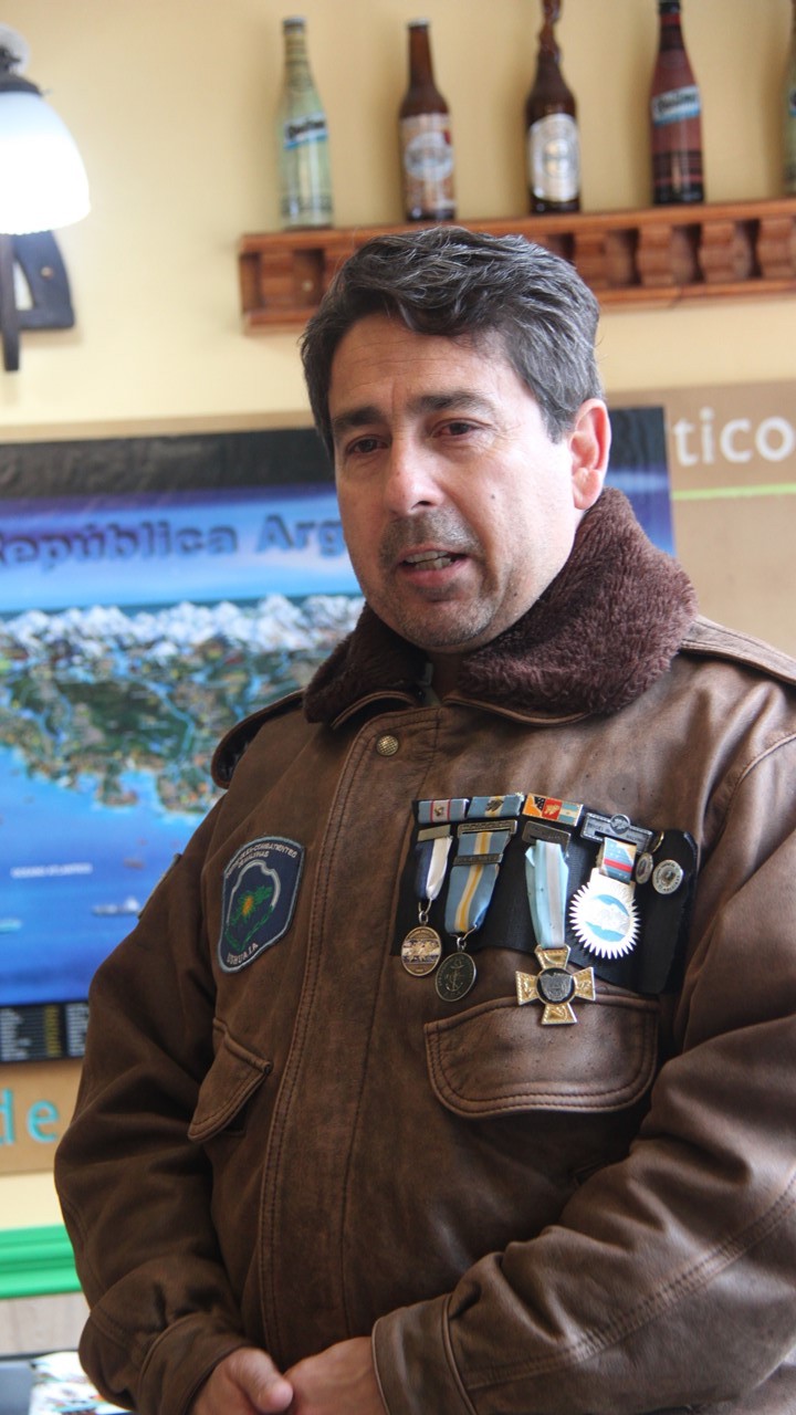
To better understand this bit of their history, we sat down in the afternoon with “Daniel”, an Argentinian Navy veteran of that war. Daniel was a young 19-year-old gunnery crew from Buenos Aires assigned to the “Hildago”, a former WWII & Korea USA “730” Destroyer. Argentina had purchased the old ship in 1970, but it was originally commissioned in 1940. Daniel’s ship left Port Arenas on March 30, 1982 with no knowledge of what their mission was, and immediately headed to the Malvinas in a support role for troops that were sent ashore there.Only once underway were they told that Argentina was taking the Malvinas back from the British. The young sailors were shocked and surprised, but they were proud and excited. As a support vessel, they backed up the ships that had arrived to take the Island’s port where there were ~300 civilians living.The first death came soon thereafter – an Argentinean Commander.However, they took the port and had expectations of success and a quick victory when no more troops or ships arrived.
Daniel – Argentinean Veteran of Faukland War
Soon thereafter, the British announced a 200 mile “exclusion zone” around the islands and backed it up with the British Navy.On April 11th, the Hildago had a mission to the south to protect communications’ lines and support another Destroyer in a planned Argentinean attack on the British.The Argentineans moved inside the exclusion zone for the attack, but, at this time, the South Atlantic was very rough, and the Argentinean Navy lacked the technology to coordinate an attack in such bad weather, and the attack was cancelled. While coming back to position outside the exclusion zone on May 2nd at 4pm just before dark, the “Submarine Attack Alarm” went off and the crew scrambled to their positions.Daniel worked in the forward “Combat Tower” as part of the artillery.He was heading to the restroom when the alarm sounded, and as he ran for cover, he could hear the torpedoes bypass their ship.Instead, their sister-ship was hit!They began anti-submarine maneuvers throwing depth-charges overboard, but the seas were over 25’ high and they did not have the technology necessary to be effective.Their sister ship began to sink with all 700 crew aboard, but the Hildago was ordered to leave the exclusion area immediately. After 10pm, they returned to the area to look for survivors. On the next day they found their first raft of survivors, terribly hurt and burned with petrol and with body parts missing.It took them many hours to rescue all the survivors, working against the clock in terrible weather.In the end, they rescued 277 survivors, but their ship was only a crew of 300 and their ship was overcrowded to the extreme with 577 now aboard.Those aboard gave the injured everything they had – food, beds, clothes, medicines – whatever it took – still today those involved remember how awful and bad it was.When the ship returned to Ushuaia, they began to receive news via the local radio stations saying that Argentina was winning the war, which those aboard knew wasn’t true.
Daniel’s family had no knowledge of either himself or his 17-year-old brother who was also at sea in the Navy. The lack of information and the lies that the dictatorship was telling made it a very difficult time in the country. The rendition and the end of the war was on June 14th, and when they returned to their home port, there was no one their to greet them or welcome them home. The most difficult moment of all was when he finally got to see his father whom he hardly recognized. His father has lost a great deal of weight and had aged considerable in such a short time with worry and grief over the unknown fate of his two sons. When Daniel returned to his old neighborhood in Buenos Aires, neighbors would come up to touch and hug him.Daniel remained on the Hildago until 1983 and retired from the Navy in 1984.He moved to Ushuaia and works with the many local veterans that retired there. Last year 120 veterans died from cancer, heart attacks, and suicide.He received medals for Combat, the Presidential Medal, and the Province’s Remembrance 35th Anniversary Award.His final comment was:” We went as hero’s but came home through the back door“
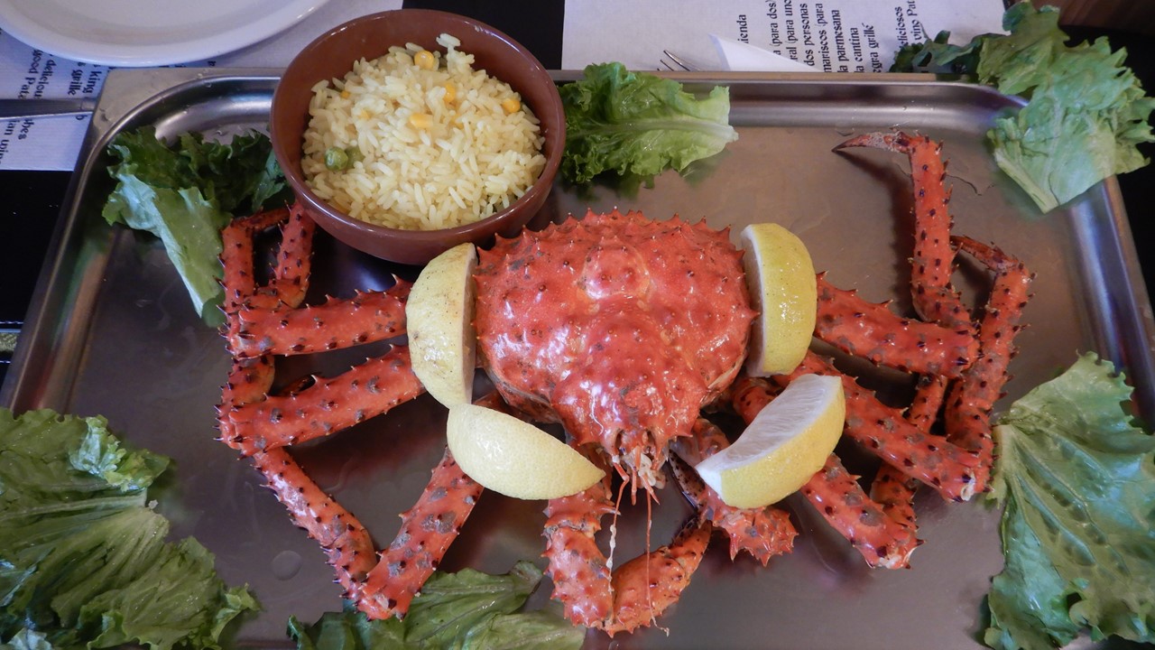
After such an emotional engagement, we stayed for a group dinner at “La Cantina de Freddy”.There we had crab soup followed by whole king crab with butter, rice and french fries. Dessert was a bonbon with Patagonia Calafate berry ice cream – an amazing meal!
King Crab Dinner in Ushuaia
Wednesday morning, we walked to the nearby former Ushuaia Prison, which houses 4 interesting museums in the radial arms of the former jail-block’s: the Argentina in Antarctica Museum, the Military Prison Museum, the Ushuaia Jail Museum, and the Naval Models Hall. After the tour, we walked down the town’s main street, San Martin Street, for some shopping, (they have a Hard Rock Café)!
For lunch, we visited a local couple, (Gaby & Gustavo), who are raising their two daughters, (Lara – 7 and Sol – 12), in a nice home up on the side of the hill overlooking the town. We explored their home and learned about their lives here in Ushuaia. There were both in the travel agency business and enjoy meeting travelers from around the world.For lunch we had lentil stew and spinach cheese biscuits with milk cake and meringue, and brownies with caramel and chocolate for dessert.After lunch, we had a lively discussion about the building of their house, family, education, and the custom of mata – a tea-like herb that is mixed with hot water and sipped through a filtering straw.It is the most common form of greeting and social interaction among Argentineans.
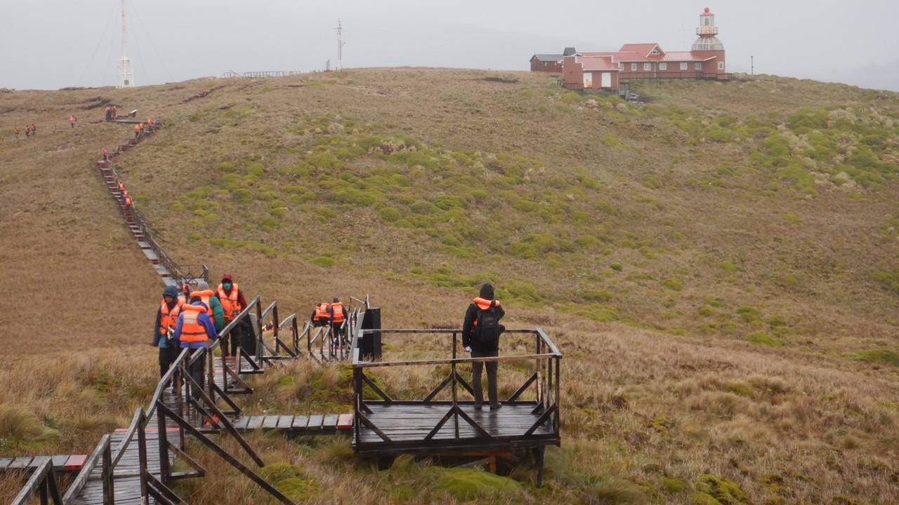
After lunch, we visited the Tierra del Fuego National Park which makes up much of the island.It was created by Francisco Murano and was the first national park in Argentina created in 1960.Today, one of the park’s glaciers is named after him. Argentina and Chile share the 3rd longest border in the world and the island is shared between them. The road, Route 3, is part of the Pan-American Highway stretching over 28,500 miles from Alaska through Buenos Aires to its ending in the park.After walking to “The end of the Road” we visited Ensenada Bay Post Office and received passport stamps marking the occasion.We then hiked through a series of trails that took us through forest of beech trees, gave us great views of the east-west Darwin Mountains, and the Andes in the distance, and took us through sub-arctic meadows. The beech trees here are not true beech trees, and as called “false beech trees”.The can grow to 100’ high and can live up to 500 years.There are three types, including one that stays evergreen throughout the winter. We then took a hike along Lake Acigami, (Lake Roca) where we were in sight of the border with Chile. We then made a brief visit to Lapana Bay, a “false” lake that is actually part of the Beagle Channel.We then returned to Ushuaia to board our ship, the Stella Australis – our home for the next 5 days.
The ship had large guest rooms with good size private bathrooms. There was an open, outdoor viewing deck on the sixth level, and a large comfortable indoor lounge (Darwin Lounge) with open bar and an outdoor stern viewing deck on the fifth level.The fourth level housed the Bridge and had a smaller lounge (Sky Lounge) with staterooms, as did the third level (Yamana Lounge).The second level included the Reception Desk, Gift Shop and more staterooms, and the 1st level were crew quarters and the kitchen and dining room.There were many screens around the ship with activities listed, as well as a GPS tracking of our route.Meals were at 8am, 1pm and 8pm. All excursions would depend upon weather, wind and waves, but, in general, there were two planned every day!We left port and made our way south into Chile and out of the Beagle Channel, heading for the famous outpost, and our first tentative excursion in the morning – Cape Horne!
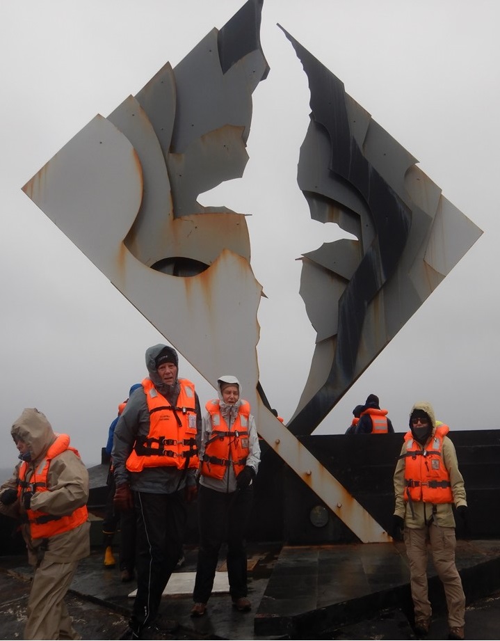
These islands became a National Park in Chile in 1945 and became a UNESCO World Heritage site in 2018. Cape Horne is the most southern inhabited place in the world (other than Antarctica), and the lighthouse there is manned by a Chilean Service man with his wife and children. Cape Horne is still 593 miles from the Antarctic peninsula and is renowned for the more than 800 documented shipwrecks that have occurred there, and the over 10,000 sailors who have died trying to round its point. The seas and weather here are highly variable, and our likelihood of being able to make a landing tomorrow is only 50-50%.
On Thursday morning we are lucky and the seas (4-8 ft) and wind (20-35 knots) are manageable, although it is cold and raining and sleeting. Before breakfast, the crew lowers the six 10-man zodiacs that are carried on the top deck, verify the safety of the landing, and begin taking ashore 10 at a time.We are in the last group of 30 planned to disembark, and while we are waiting, the wind picks up and the seas grow.The Captain begins to get worried, and although he allows us to travel to shore, he cuts short the visit of the passengers already on shore so that he can begin to bring them back to the ship. We make it to shore for a strenuous 120-step climb up the hillside to the Cape Horne monument to the lives lost there, braving winds in excess of 40 miles-per-hour, protected in our layers of waterproof gear.After making it to the top, we do not have time to visit the lighthouse or the chapel, or visit the family living there before we begin our descent back to the boats to return to the ship.The weather continues to degrade, and we finally arrive at the ship in time for the Captain to lift anchor and head back north for the safety of the islands and to reenter the Beagle Channel.
The Landing at Cape Horne
The Albatross Monument at Cape Horne
View of the Lighthouse at Cape Horne
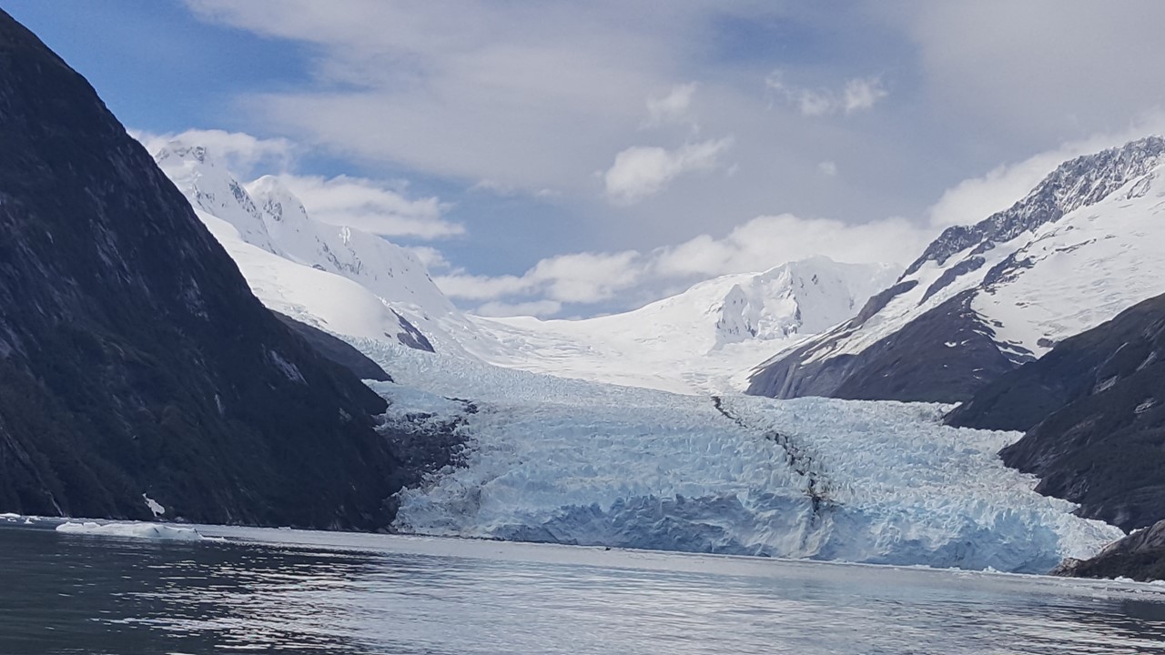
After breakfast, we took in a film on Shackleton’s ill-fated journey to Antarctica and the South Georgia Islands which covered over 400 days of starvation, heroics, lost at sea, and frozen in ice – but with no casualties! A true miracle!After lunch, and in better weather in the Beagle Channel, we again boarded the zodiacs, and headed to shore in Wulaia Bay – the site of an historical house from the 1930’s that served as an old radio station of the Chilean Navy, and that was put here to support their claim to the area.
Inside the historical house was a big barrel that visitors could deposit post into, and from which travels could take post out under the condition that they would see that it was delivered. This was the typical postal system for many years for the sailors that passed through this region and were away from home for years. Beyond the house was a series of optional hikes, and we took on the “Demanding” one that entailed climbing the local hillside through beech forest and over rumbling streams to an 800’ high lookout with a view over the Bay.The 16 of us trekked for over an hour, up to a spectacular location where we sat silently for minutes enjoying the view and the sounds of nature. Along the way, our guide, Luciano, related the story of a Yamana local boy named “Jimmy Button” by Darwin, and taken by him to England to be “civilized”.For 2-years, Jimmy was the hit of London, learning English and aristocratic customs, wearing fine clothes and even meeting the Queen of England.When Darwin then brought Jimmy back to Wulaia as his emissary to convert the natives, the Yamana, to Christianity, Jimmy disappeared for some time, but when Jimmy finally reappear, naked, with his mother and tribe-folk, he told Darwin that he would always be the son of his mother, and he would always remain Yamana.Jimmy left behind his fine clothes, his “civilized” customs and left with his people to never be seen again
View of the ship and Wulaia Bay from the Viewpoint
Today, the island has issues with mink, beaver and rats, all introduced by European settlers and trappers into the area for which no natural predator exists. The beavers were brought from Canada to start a fur industry, but with no predators and a different climate, their coats changed making their pelts worthless. After making the equally difficult climb down and returning to the dock to board our zodiacs, we were greeted with hot chocolate with a shot of whiskey. Then it was back to the ship for showers, a dinner of beef tips or spaghetti, and a movie called “Living on the Edge” about life of the penguins and seals in the area.
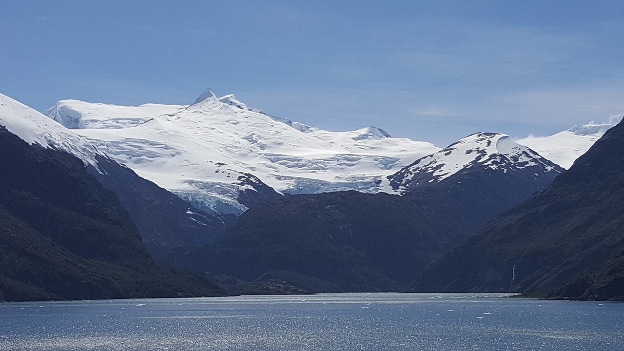
The Ice Fields of The Darwin Range
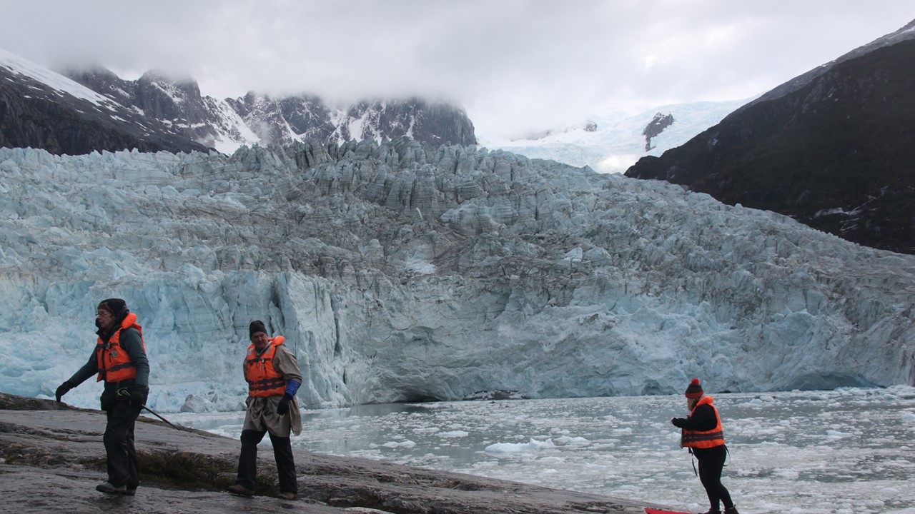
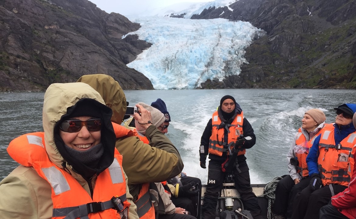
On Friday, we were well into the Darwin Mountain Range, and are greeted at every turn with soaring mountains, glistening icefields, and glacier-filled valleys. After breakfast, the ship set anchor, and we boarded our zodiacs to go ashore and explore the Pia Glacier.This glacier is a tidewater glacier that, along with many of its neighbors feed an enormous number of icebergs floating around the ship and among the zodiacs.The calving takes place on this glacier every 10-15 minutes, with a multitude of loud cracks and pops in between.Our zodiac maneuvers through the ice floes before landing us on a large rock positioned on the side of the glacier-carved fiord, just a few hundred yards away from the glacier’s blue-ice face.From here, we spend some time watching and observing as ice chunks drop off into the sea with a thunderous boom. The Pia Glacier if slowly receding, but not at a steady rate, as it is highly dependent of the amount of snow in the icefield feeding it that falls on a yearly basis.Many glaciers in the Darwin Range are, in fact, growing, or are stable.To the one side of the Pia Glacier is the Sinos Glacier – a hanging valley glacier that does no longer reach the sea, and which consists today of a massive ice sheet covered with rocks and dirt, obscuring the view of the ice below it.After a bit, we climb a few hundred feet up to a better viewpoint where we can observe the glacier.For the first time of the day, the sun came out making the ice sparkle.We finally left to re-board our zodiacs, enjoying our customary hot chocolate with whisky at the shore first.
The Pia Glacier from the Zodiac
Climbing the Shore near Pia Glacier
Climbing to Viewpoint with Sinos Glacier in the Background
View of the face of the Pia Glacier
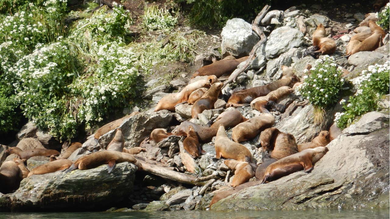
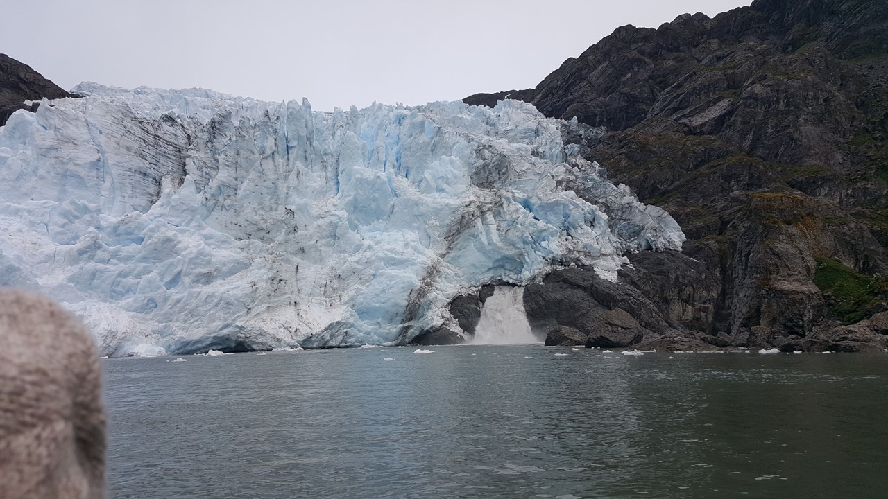
After raising anchor, we began a journey to our next fiord.During lunch, the number and size of the icebergs grew tremendously, and the Captain announced that we would not be able to maneuver any closer to our destination, the Garibaldi Glacier, and he set anchor.Although this would mean that we would not have enough time to take everyone to shore, we would still be allowed to board the zodiacs for a boat-ride to the fiord and to approach the face of the glacier.The Garibaldi Glacier has receded almost ½ mile from its terminal moraine, which makes a natural levy at the exit to the fiord.However, there is enough room for the zodiacs to enter the fiord, and to avoid the rocks and the kelp beds that flourish in the perfect mixture of water from the sea and melt from the glacier.The glacier has been stable for the last 75 years, but no one knows exactly why.After enjoying the view at the face of this tidewater glacier, we began our trip back and ran across two large pods of sea lions on the rocks on the shore.Each pod had a dominant male and a hareem of females, many of which had either just given birth, or who were in the process.The birthing activity and the tiny black pups attracted the interest of a flock of predator birds that circled low overhead.After getting as close as we dared for pictures, we returned to the ship for drinks, dinner, and a movie, “Fire & Ice”.
The Stella Australis Ship while heading to Garibaldi Glacier
The Garibaldi Glacier
The Sea Lion Colony with their Newborn Pups
By Saturday morning, we had traversed the Cockburn Channel and entered De Agostini fiord and the De Agostine National Park. After breakfast, we set anchor ourside the Condor Gracier terminal morraine and prepared to board the zodiacs. In the early 1900’s, the Condor glacier extended to front of the bay and was stable but beginning about 70 years ago it began to melt rapidly and recede, and did not reform, as many of the other glaciers did. A huge waterfall pours from underneath the glacier as the water carves its rivers underneath the ice.It is still not understood why some glaciers in this region are growing, some are stable, and others are receding, such as the Condor Glacier.On the return to the ship, we saw several cormorants as well as some small kelp geese.
Riding the Zodiac in front of the Condor Glacier
The Condor Glacier
After lunch, we moved briefly to the entrance of the Aguila Glacier and assembled or small group oshore for a hike along the beach created from an ancient terminal morraine.The morraine formed a high arc nearly a mile long and 100-200 yards wide, but it was densely populated with trees, bushes, flowers and berries such that we needed to hike around the terminus end of it and back around the inside of the arc to a protected bay fed by the Aguila Glacier Although the Aguila Glacier appeared to terminate into the bay, it was actually sitting on a bed of rock and had been stable for as long as anyone has recorded it.We hiked up to near the glacier’s face and observed the rocks and cavern along the edge of itAfter taking a small “nature walk” through the dense nearby forest, we hiked back the way we came for our “post-hike-treat”, and our trip back to the ship.
The Aguila Glacier
Saturday night, the ship would exit the Island Channel’s and enter into the Pacific Ocean, before entering the Straits of Magellan at it western end. The Straits of Magellan is 310 nautical miles long and was the primary route for the transport of goods and people to a growing California and USA West Coast until the Panama Canal opened in 1914.Early Sunday morning, we will pass Cape Forward – the southern-most point along the Straits of Magellan route. Then we will head north within the Straits until we reach our final destination port – Punta Arenas. We feel the rolling of the ship in the night and we arise early to see the sights, but we are disappointed to find the we are setting anchor just off the port.During the night we lost one of the ship’s two engines, and the ship can travel no further.We had hoped to get a chance to visit nearby Magdalena Island – home to over 60,000 penguins.However, it was not to be, and when repairmen were unsuccessful, we were forced to wait for tugs to come and push us in to the wharf.While waiting, we were fortunate to spot a number of whales spouting in the area, which kept us entertained until we finally departed the ship at noon.By the way, the problem was so serious that the next two trips on the ship had to be cancelled.
As an aside, Magdalena Island is a Chilean National Park where penguin colonies can be observed close-up. There is a coastal path to the lighthouse (~850 meters hike) where the Magellanic specied of the 17 different species of penguin can be found.They are not too tall (50-70 centimeters) and can live up to 20 years.They typically weigh 3.5-5.5 kg and are heavy and dense.Their chick is grey and fluffy and does not develop it characteristic marking until it is past 3 years and becomes a full adult.Penguins spend 80% of their time in the water, and the 20% of the time on land is for molting, birthing and caring for the chick. They waterproof their feathers with an oil they secrete and must be ever vigilant onshore for bird that will attack their eggs and chicks, and in the water where seals and whale seek them for food.Fishermen used to use them for king crab bait in the crab traps, but that practice is now illegal. The breeding males arrive on the island early in September and begin to make their nest in preparation for the arrival of their partner (penguins mate for life). When the female arrives, she adds twigs, etc. and the couple engage in beak kisses and vocalizations (raising their head in the air and making sounds like a donkey).They then mate, the female lays her eggs, and incubation takes 35-40 days, (both male and female care for chicks) Penguins eat just fish and squid and they molt once a year where they over feed, come to land and molt, and don’t return to the water till their new coat is ready.
The 500th Anniversary Sign at Puenta Arenas
After we leave the ship, we enter Customs, and then explore the town on Puenta Arenas.This Port was founded in 1520 on a strategic point (Puenta) of land along the Magellan Strait,Today, this southern Patagonia city houses 120,000 people of the 160,000 in the whole region., and is really the only large city in Patagonia. The City Square houses statues of statues of Magellan and Mermaids holding the coat of arms of Chile and Spain surrounded by natives.The area has a long history of influences from the British explorers and their navy and today still observe tea time.The main meals here are still lamb and potatoes and the town was beginning to make preparations for celebrating its 500 Birthday next year.However, we had a long bus ride ahead of us as we were traveling north in Chile to the Torres del Paine National Park – over a day’s travel away.Next stop – Puerto Natales!
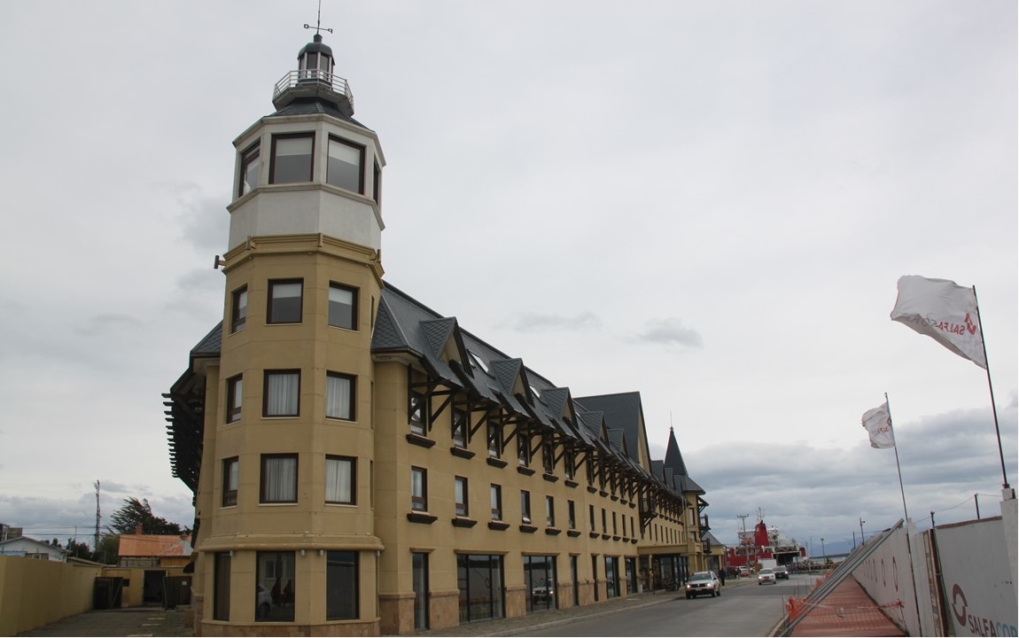
We arrive in Puerto Natales by late afternoon.Puerto Natales is also on the Magellan Strait, but is a small town of only 21,000 people.It is a popular town for hikers and campers to kick off their exploration of Patagonia.We check into our waterside hotel, and head off to shop the Herman Eberhard Street crafts, shops and restaurants.This town has made all plastic bags illegal because of the strong and constant winds that make them such a nuisance. That night, we dined on salad, salmon and dessert before calling it a night, and getting ready to set off by bus again in the morning for our all-day bus ride to Torres del Paine National Park.
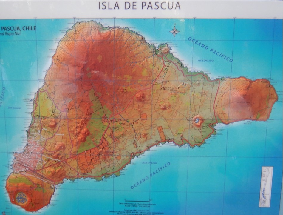
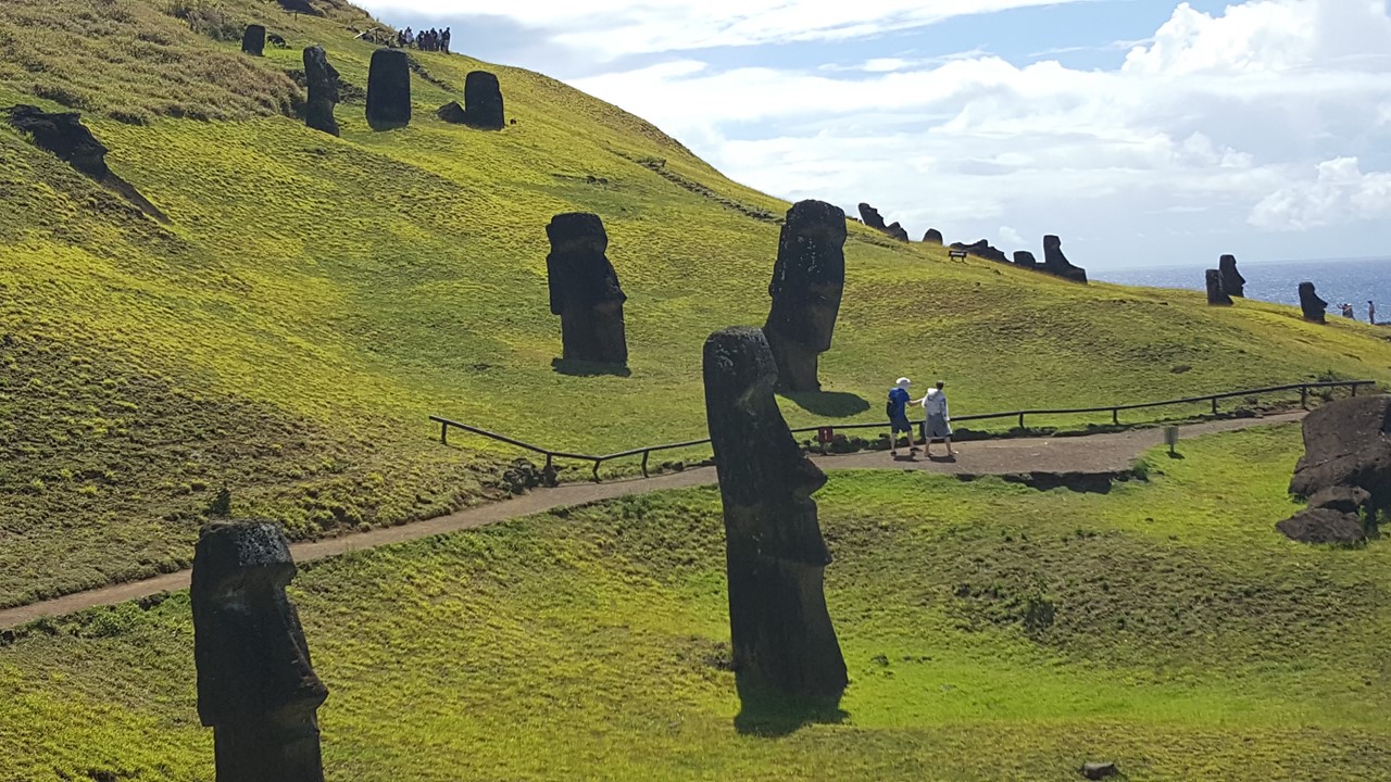
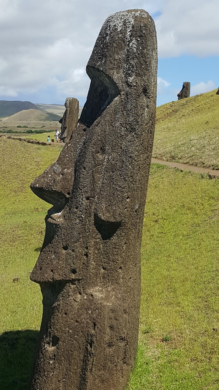
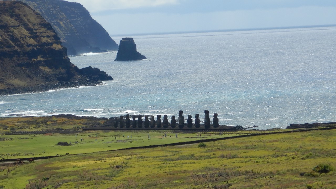
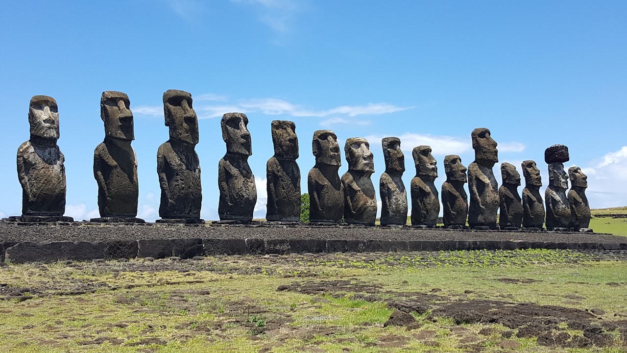
Tuesday, January 9th, 2019, and today we paused our exploration of Santiago, Chili to head to one of the furthest outposts of mankind – Easter Island!Easter Island is the most isolated, inhabited place in the world – many thousands of miles from any other inhabited place, and a long 5 ½ hour plane ride from Santiago. European’s named the island because it was discovered on Easter Sunday.
Easter Island, (“Isla de Pascua” in Spanish), or Rapa Nui as it is known by the native Polynesian ancestors of its first inhabitants is also known as “the naval of the world” harkening back to local beliefs that all spirits’ power originated there.The island is formed from 3 ancient volcanos, (Rano Kau, Poike, and Maunga Terevaka) forming the apexes of a triangle, with the southwestern one providing the peninsula for the airport and the island’s only town – Hariga Roa. The airport is quite modern, and the runway is the longest in the southern hemisphere, as it was built by NASA as an alternative landing site for the US Space Shuttle. Our “hotel” is a lovely but quaint “mom and pop” establishment with beautiful gardens of fruit trees and flowers, located in town just up the beach from the island’s principal harbor, beach and port.From here one could watch the bevy of local surfers, eat at a range of the town’s restaurants, or observe the Oceana Cruise ship “Marina” (1275 passenger & 800 crew) sitting in the harbor. For our stay, we had a local Rapa Nui descendent, Noi, who would serve as our guide, and who, along with our trip leader, Meche, and our dedicated driver, Jose, would be sure we got to see and understand the island’s history and sights.
Map of Rapa Nui
Rapa Nui was likely settled in the 13th or 14th century by Polynesians sailing from Tahiti. They brought with them all that they thought that they would need, but the island offered no mammals, sparse fishing, little fresh water and a lack of resources with which they could build boats to ever leaveIn spite of the hardships, the original few hundred Rapa Nui grew into a civilization numbering over 10,000, before civil unrest, starvation and fighting shrunk their numbers considerably.When Europeans landed there in the 1600’s, the introduction of disease and foreign species reduced the Rapa Nui to only a few hundred from which their descendants today are derived.
Soon after we check-in, we set out into town to visit a local grocery/bakery, where we stock-up on water & wine, and get to sample the largest empanadas we have ever seen, (~10 inches long filled with creamy cheese and tuna). Then we headed north to Ahu Akivi – the only group of Moai not along the coast and whose platform was erected during the 14th century facing the water.These seven Moai statues were toppled around the 15th century but were restored to upright status in 1961.They are set to align with the winter solstice.
The Moai at Abu Akvi
The Rapa Nui society was initially ruled through lineage to one of the 12 “clans” that had divided the island, and a single king.The King was thought to be Godlike, and the Moai were erected by families as a way of collecting the power of their souls – their “manna”.The Moai were only represented from pelvis to head with no limbs and sculpted androgynously.There are 1045 known Moai’s worldwide, however, only 1020 are still on the island and many of these are still in the in the local quarry at various stages of completion. Once their sculpting is complete, the Moai were then moved to the sites where they will stand. Today, there are still 400 statues at the quarry. Important members of the “clan” are buried in the platforms surrounding the Moai, so all platforms are sacred. The eyes of the Moai are open mean the manna is alive in the Moai. Nearly all Moai face inland from the shores, facing the people. These Moai at Ahu Akivi are rare as they are facing ocean. The eyes of the Moai were painted or decorated with shells or coral, as the Rapa Nui believed that if there were no eye socket, then the Moai had no manna. The first restoration of Moai took place on the island in 1951. During the fall of the Rapa Nui civilization, the Moai were all pulled down with their faces facing down to destroy the manna of the rulers, so many Moai were re-raised in recent times, although many remain damaged from their fall.In addition, many of the later Moai that were erected were fitted with “top knots”, or “tocow”, on their heads.These were circular crowns carved from a specific reddish pumice stone that is lighter in weight so that it could be raised to the top of the Moai.It would take 8 months to 2 years to carve a Moai, but no one is sure how they were moved to their platforms.
Rainbow over the town of Hariga Roa
After visiting Ahu Akivi, we were supposed to travel to Puna Pau – the quarry where the top-knots were carved.Unfortunately, the quarry and the road were closed for maintenance. Therefore, we traveled to Aruenga – a private property with a single Moa located on it. It also faces east aligned with the summer solstice, but this Moai actually has 4 hands engraved upon the stone – the only one on island like this and one of the few on lands not specifically controlled by the military during the times when the island was ruled by the Chilean Navy.
We then returned to our hotel for a quick freshen-up, and a brief 10-15-minute walk to a waterfront restaurant for dinner on the outdoor second floor balcony overlooking the oceanfront. Dinner was a salad followed by a tuna fillet with smashed sweet potatoes and strawberry passion fruit ice cream. As the sun set on the horizon, we watched the sailboats at anchor and the long boats, kayaks and surfers enjoy the last light.
The next morning, we traveled east to the coastal area of Vaihu, where a typical “family center” of life of the Rapa Nui has been recreated.All structures are made of stone stacked up in creative ways.We were surprised to see long stone piles resembling upside down boats that serve as chicken houses known as “hare moai”.Our guide, Noi, removed a stone from the wall, and out came a steady stream of adult and baby chicks.
Chicken emerging from their hare moai at Vaihu
The rocks are also used to make circular gardens whose tall walls protect plants from animals and winds and yet keep moisture inside.Grasses were used to make similar boat-shaped houses, “hare vaka “, including a stone porch for more wealthy. The houses were only used for sleeping, as everything else was done outside. Each family group would have 4-5 houses at their center.
Next, we continued east down the coast to Akahanga where we encounter a series of Moai facing inland, but still toppled and with their topknots removed. With the eyes facing the ground, the belief is that the manna is gone. Here we found at least 27 Moai in three platforms of 9 each and with a crematory on the point of land located behind one.These crematories are still used and revered, and we were careful to respect the area.Above the Moai was a large cave believed to have been used by workers and serving as the source of stones used in the “Ahu” (platform) construction below.
We then continued our journey east to the famous quarry of Rano Raraku, where ~400 Moai remain in various stages of sculpting and movement. All Moai are carved at top of mountain while still attached to the earth along their back. The Moai is then cut out at last and gently moved down hill into a staging hole where it was slid into an upright position and sculpting was completed.Moai’s left in this position have had their holes filled over the years, but 33 years ago one was dug out and exposed and demonstrated that it now extends 75 feet underground.After walking around the quarry and looking at the many Moai abandoned there, we came upon the most unusual Moai on the island, a sculpted man with a goatee in a kneeling position.
The Moai at the Rano Raraku quarry
Unfinished Moai still at Rano Raraku with over half underground
Next, we continued our travels east along the coast to one of the more famous settings at Tongariki.This large platform located on the southeastern coast was the setting for 17 Moai by the quarry’s owners, demonstrating their great wealth and strong manna.In 1960, an offshore Chilean earthquake generated a tsunami which came ashore and toppled and scattered the Moai over a large area.After this, one Moai was taken on world tour to raise funds to restore them, and today, 15 Moai stand back at the site, (2 Moai were too damaged to re-raise them, and they still sit in the field nearby. Originally, all these Moai had topknots, but today, only a single Moai could be restored with this component.
The large platform at Tonganki
The Moai at Tonganki
From here, we drove north across the island to the northeast shore to Anakena, the site of a platform with restored Moai, and the islands only swimming, white and pink sand beach.Here we changed into our bathing suits and swam between the black lava rocks in the gentle surf of the Pacific and sunned ourselves on the beach.In ancient times, an offshore carbonate reef provided the materials for the sandy beach here.After a refreshing break, we returned to the hotel for dinner on our own.
The beach at Anakena
For dinner, we strolled south along the waterfront of the surfing bay and checked the menus at several places before settling on Haku Hanu.Here we sat on the patio watching the surfers and enjoying our Pisco Sour and jumbo shrimp meal. After dinner, we walked to a small restaurant behind the town’s soccer field to meet up with our fellow travelers and enjoyed another round of Pisco Sours.On our way back to the hotel, we passed the local gym where, hearing music, we stopped in to see the local townsfolk practicing native dances in preparation for the local festival next month. It was very interesting as there were over 100 women there dancing along with a few men. January and February are the summer months in Rapa Nui, and the schools are out of session, and the island’s festivals are in full swing. We then strolled along the main commercial street looking for souvenirs before returning to the hotel and calling it a day.
We started Thursday with breakfast before driving south to Vaiatare and up to the top of the Rano Kao volcano crater’s rim. In the later stages of the Rapa Nui civilization, this site known as Orongo, was sacred, and was where the King lived and where sweet potatoes were first grown. In ancient times, Manutara migratory birds would come to the offshore islands during September and the Rapa Nui families would send a representative to compete in the Bird Man Competition to decide the next year’s King and ruler. The Bird Man Competition consisted on being the first man to bring an unbroken egg from the Manutara bird’s nest, which entailed climbing down the rocky cliffs, swimming the frigid, dangerous Pacific waters to the offshore island, scaling the cliff faces to get to a nest and returning with the egg intact being the first of the year. The last of these competitions took place in 1886, but no birds come there any longer.
Remnant Birdman Houses at Orongo
Offshore Islands where Bird Man competitors would seek the first egg
In the early years, Peru took thousands of Islanders as slaves and Jesuits brought European diseases leaving less than 200 native survivors. Today there are around 4000 natives recognized as descendants. 54 of the local houses used by the competitors are still there, although many drawings and petrographs had been stolen by foreigners. This spot is the coldest and windiest place on island, so people lived elsewhere most of the rest of year. The Rano Kau crater is protected and only native Rapa Nui people are allowed to hike into it for spiritual reasons. The crater contains plants not found elsewhere in the world, although the water in it is only 8-10 meters deep.For the ancient Rapa Nui, this was one of the few sources of fresh water on the island.
On the other side of the volcano, we visited the Vinapu site where there were two platforms: Vinapu and Taheda.The platform at Vinapu was constructed with a different style using large rectangular blocks mixed with large squares, carved to fit together perfectly and without small stones – more like Inca culture used. These platforms were constructed at the beginning of Modern Era late in the Rapa Nui civilization. The second platform was destroyed when European explorers went looking for gold, noting the similarities to Inca architecture. At Taheda, an unusual Moai was found consisting of a female with breasts and arms and 2 heads. This Moai was recorded by earlier sketches but is missing its heads today.
We then traveled back to the north side of town where we visited the Island’s Museum that told the story of an early German explorer who took many pictures of the island and later published a book on Rapa Nui when he returned to Germany. This Museum’s exhibition told the story of the native people and the Moai and is free to all.
Below the Museum towards the coast, we walked to lunch with a local Rapa Nuian (Uri) who can trace her ancestry back to the original Rapa Nui founders. She still lives on her family land where she inherited her house, and now works on solving the issue of trash and recycling, since the island has grown population-wise. Her family served us a lunch of rum guava aperitif with an empanada starter followed by tuna ceviche w/ rice and salad.She served a Chilean wine “Akenna”. The salad was grown in the Music School’s organic garden. The Music School was built out of recycled plastics and aluminum.She let us ask questions and then she asked us questions. The meal was outside in a tent with every table set with a vase of flowers. Her property encompasses the land all the way to the ocean, including her family’s Moai with brings manna to her family.From here, we walked back to our hotel for a “free” afternoon.
Uri’s family Moai – Tahai
In the afternoon, Rocky and three others decided to arrange a trip to explore one of the island’s lava tubes.Lava tubes are horizontal caves formed when molten lava flows over the ground and the top solidifies in the air creating a tube that the hotter molten rock keeps flowing inside of. Once the molten rock all runs out, a long tubular cavern with a thin roof is left.The Rapa Nui would use these caves as a source of fresh water, a safe place to defend themselves, and as natural protection from wind and weather.We hired our driver, Jose, to take us to the Ana Te Pahu lava tube.It is located inside the National Park, and about a mile hike from the Park’s entrance.We enter through a hole in the lava tube’s roof where a collapse has occurred and are greeted by a multitude of banana trees and tropical plants that thrive in the sunlight with access to water and protected from the surface wind.After exploring a short dead-end direction, we begin the 1/3-mile hike within the tube, climbing over small roof collapses, circumnavigating pools of water, and avoiding knocking our heads on the low-hanging rocks that occasionally greet us in the darkness of the cave.We meet a British group who are also exploring the lava tube and assist them until they exit through a large “window” in the tube’s roof.We explore on until we can go no further, and back-track to exit at the British route to arrive on the surface in a mist of light rain.We begin our trek back to Jose excited by a unique adventure that was well worth our time.
The Ana Te Pahu Lava Tube
That evening, we return to our luncheon site for sunset viewing over the Moai at Tahai Beach – 3 platforms all connected by a single rock berm.Here, one of the Moai still has its eyes in place – eyes that are made from white coral) and has its red top-knot. This site also houses some original Rapa Nui rock houses, and many people are out on the hillside doing the same. Here, our guides treated us to a beautiful sunset celebration complete with champagne and nibbles, while meeting some local children and dogs, and watching a new bride who was having her wedding photos shot.
Local Canoes entering the water at Tahai Beach
Sunset of our last night in Rapa Nui
The next morning, Saturday, we were up very early to travel back to Tongariki to see the sunrise over the ocean behind the 14 Moai statues. The gates open at 6:00am, as a small crowd gathers to look at the beautiful stars.However, as the sun rose, the clouds came blocking the orange and pink colors of the sunrise making it less spectacular than we had hoped. From here, we traveled back to hotel for breakfast, showers and a final packing. Once ready, we had time for a leisurely walk around town, stopping on the waterfront for coffee and to watch youngsters taking surfing lessons. As it was Saturday morning, the town was sleepy, and few people were out before 9:00am. Before departing, we stopped in the post office to get our passports stamped for Easter Island, and then traveled to the airport for our trip back to Santiago, Chile.What a great adventure!