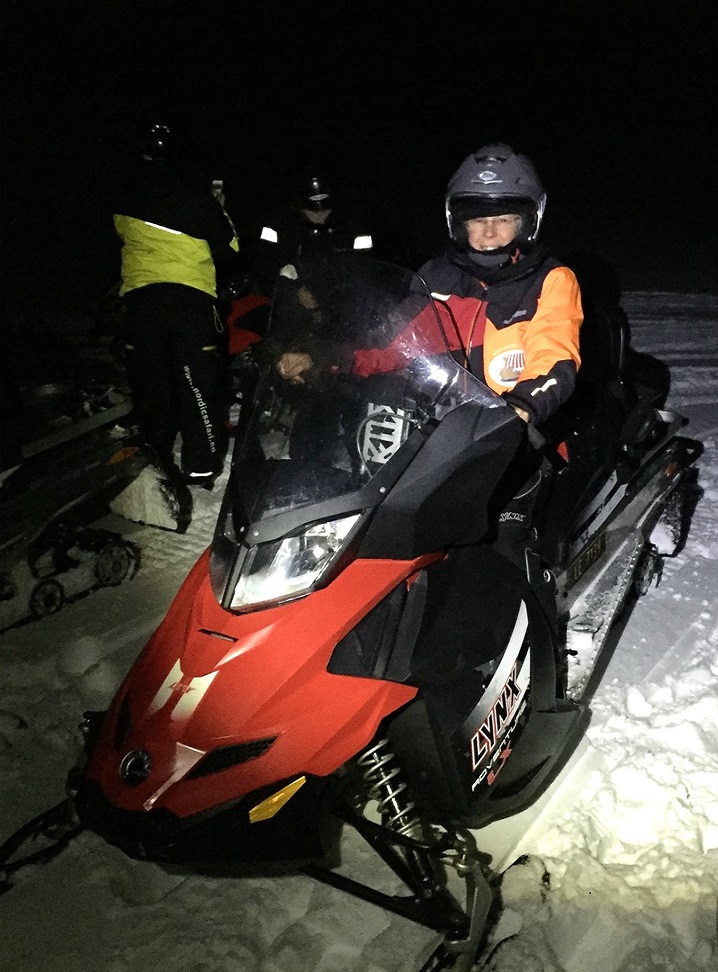
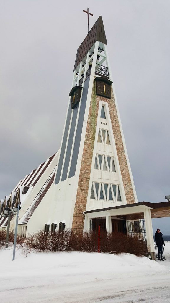
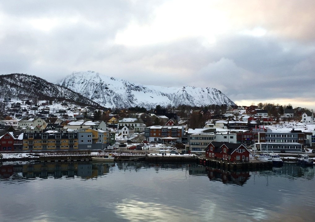
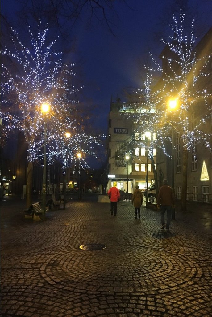
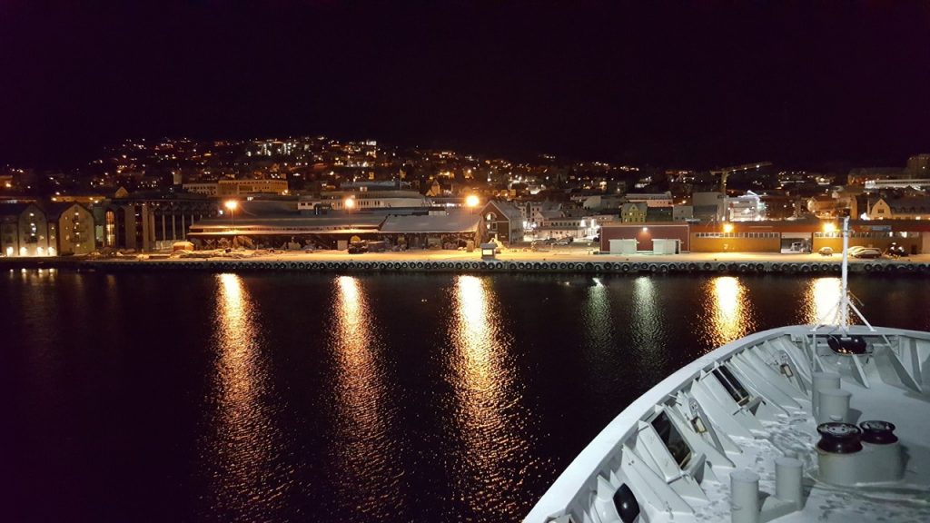
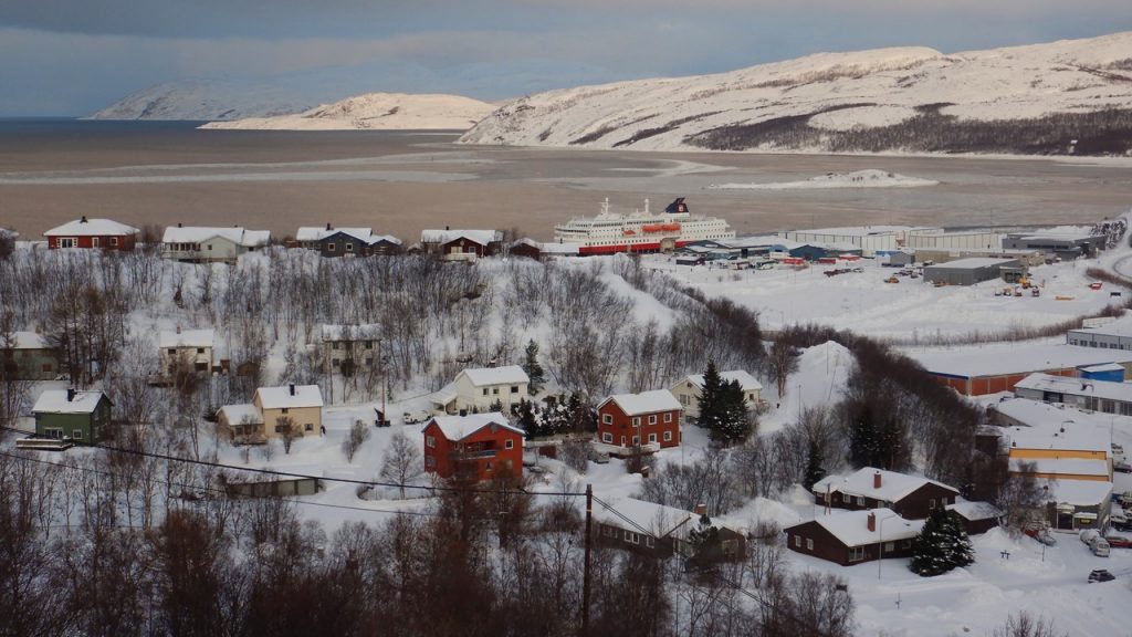
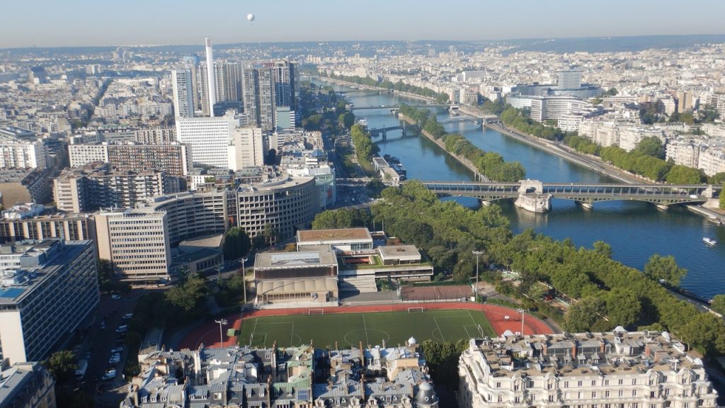
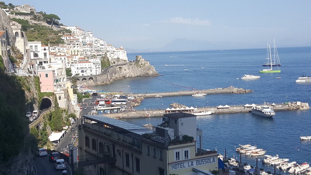
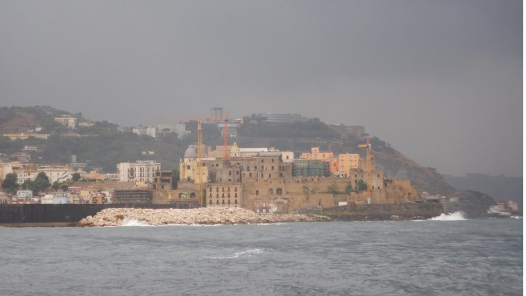
The rough weather delays our arrival in Mehamn by 90-minutes until 2:30AM. Our stop here is very brief and just enough time for Julie to disembark and join her snowmobiling group of 10 people. After a short van ride, they get dressed and suited-up and begin their 2-hour adventure traveling through the deep snow in the arctic night single file with the girls first. Initially, they travel at ~20 km/hr. heading ~1200 ft. up into the mountains. Once there, they have a brief stop with a hot fire and some warm lemonade before saddling back up and continuing their journey – this time at an increased speed of 35 km/hr. Finally, they reach a waiting bus and driver who is nervous about the degrading weather, but who successfully transports them to dock in Kjollefjord where they rejoin the ship at 5:00AM and bed down for some well-deserved sleep. Later that morning, we pass a huge Liquid Natural Gas facility loading one of its ships on our way to Hammerfest where we have a few hours to walk around town and explore. Traditionally, for over 200 years, Hammerfest had been regarded as the world’s most northern town at 70o 39’ 48”, the same as Point Barrow, Alaska. However, the definition of “town” has resulted in conflicting claims among contenders. Today’s population of 7000 is a significant increase from the 350 who lived here in 1945. We walked through the snow-covered sidewalks to the town’s historic church, and to its newer cathedral built in 1961. On the way back to the ship, we stop to collect an application to join “The Polar Bear Society” and to visit their historic museum. Then, it was back on board and off to the next series of ports arriving in Tromso at midnight. Tonight, many of the ship’s passengers will be treated to a concert in the Tromso Cathedral. We quickly board busses for the short trip to the Cathedral located just over the bridge, and then make our way up the icy path to the Cathedral’s warm pews. Soon, 3 musicians – a flutist, a pianist and a baritone – serenade us with 12 traditional Finmark songs that are lovely and haunting. After the hour-long concert, we re-board our buses to return to the ship and continue our voyage throughout the night.
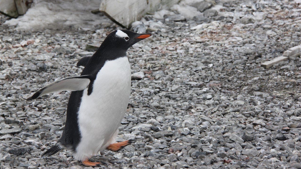
Julie Snowmobiling towards KjollefjordThe Cathedral at HammerfestJulie with Polar Bears in Hammerfest
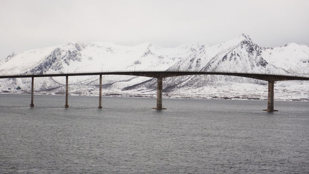
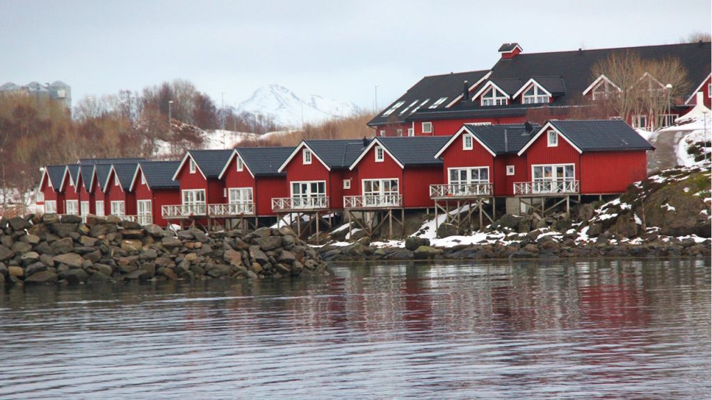
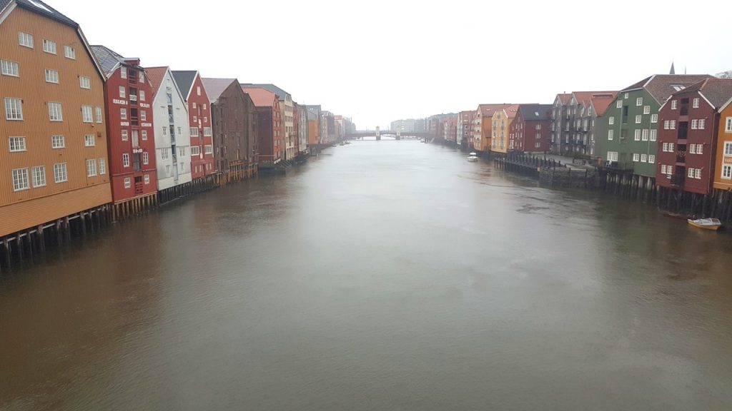
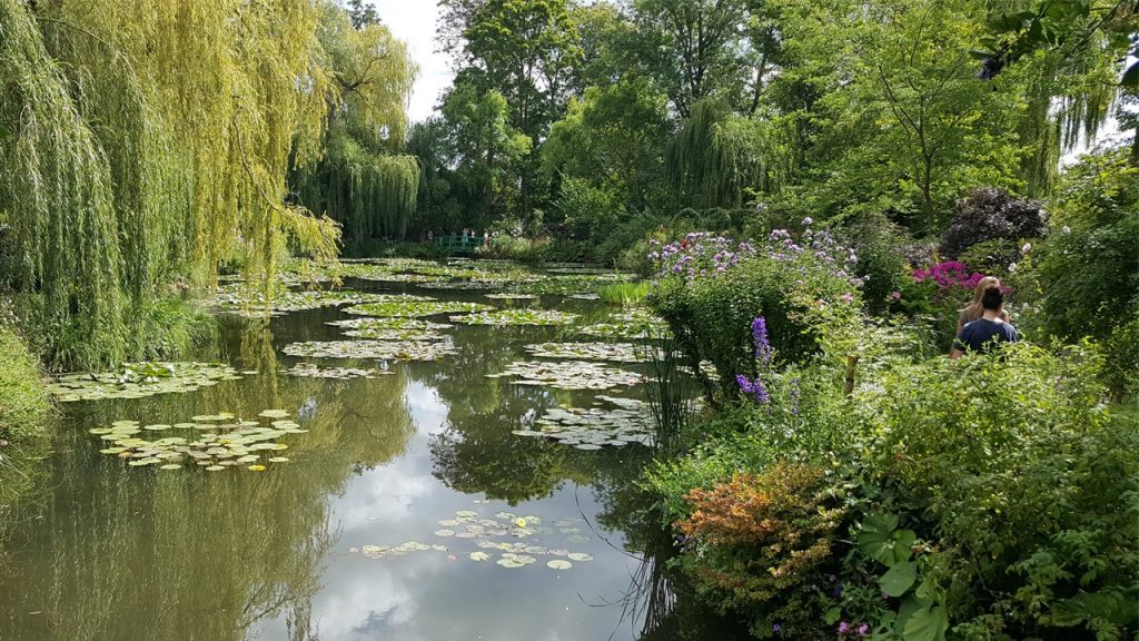
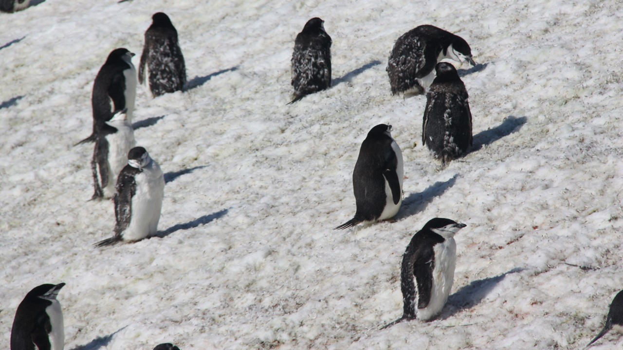
It is now early Saturday morning, February 8th, and the ship is running a few hours behind schedule due to weather and a few mechanical difficulties with the ship’s disembarkation ramp. Therefore, the Captain begins to make up time by restricting our time in each port. By late afternoon and 5 more very brief stops, we are traveling through the stunning Vesteralen Islands and crossing the Raftsund strait before arriving in the town of Stokmarknes – the home of Hartigruten shipping and their “Museum of the Coastal Express”. Here we have just enough time to take a walk up the local bridge to get a view over the fiord and town, and then it is on to dinner and a repeat visit to Svolvaer. This time we have a little more time to explore the harbor, including the island restaurant and hotel connected by a narrow wooden bridge. The ground is icy and covered with snow and we find the slip-on crampons that we have brought still necessary. After enjoying the brink air, we return to the ship for a lively game of cards with our sister and brother-in-law before calling it a night.
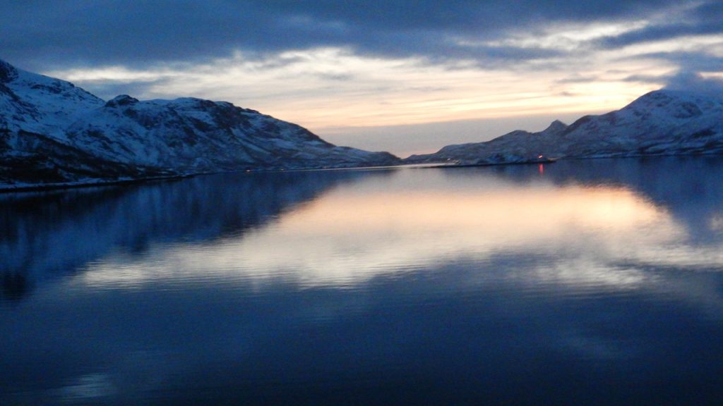
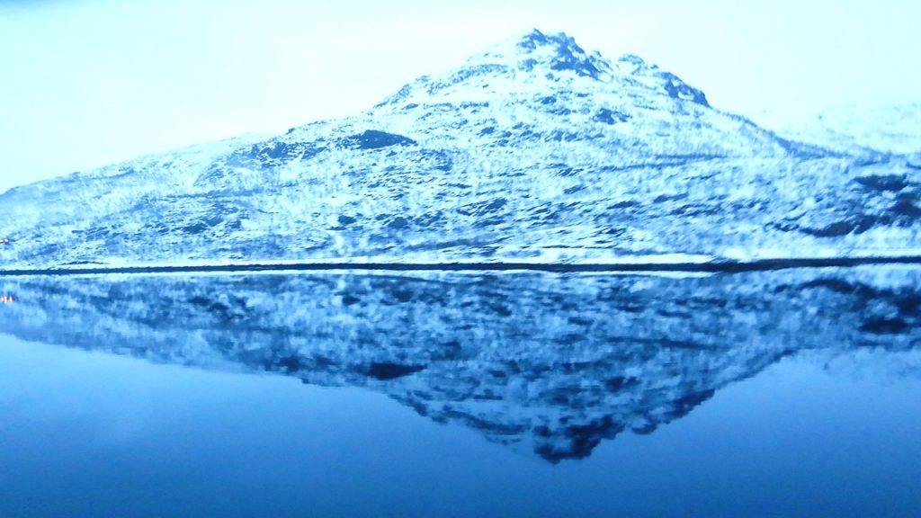
Fiord Views on the way to StokmarknesThe Bridges near StokmarknesHomes in StormarknesSunset at Blue HourBlue Hour Reflection
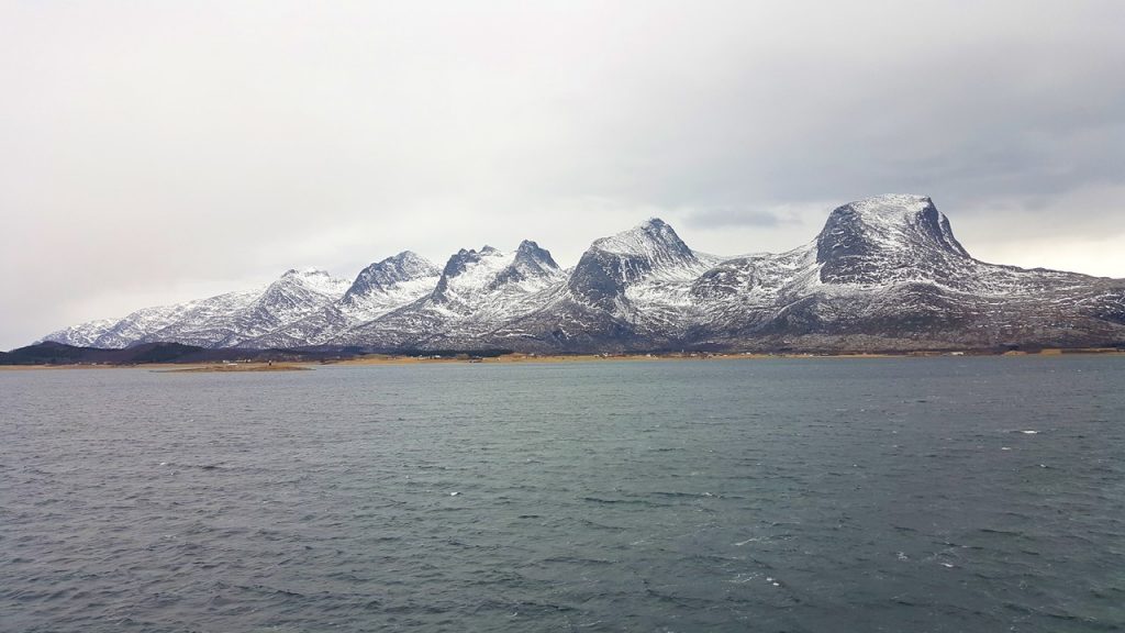
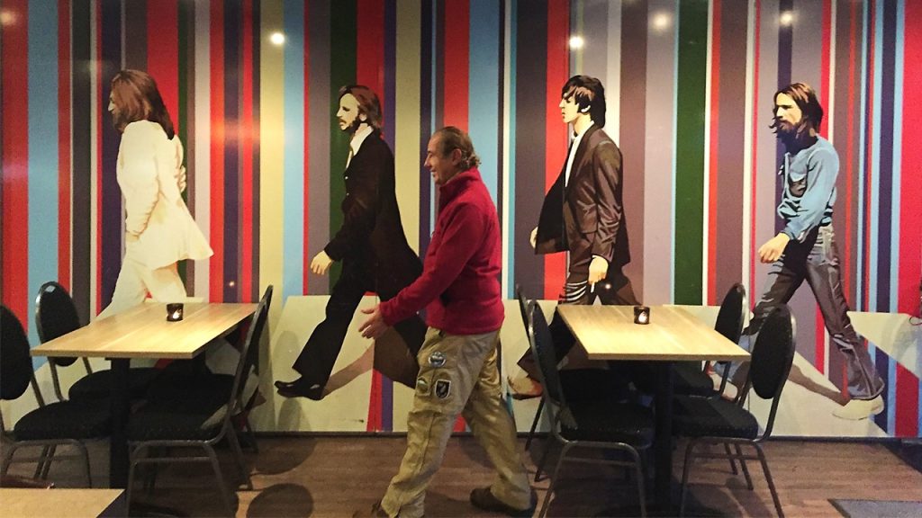
On Sunday morning we gather on deck to cross the Arctic Circle once more and continue our travel south. This time to celebrate, we each drink the obligatory serving of cod liver oil! Yes, that childhood threat of ultimate disgust that strangely is palatable as an adult, but still requires washing down with a sparking glass of champagne. Soon after lunch, we assemble on deck again, but this time to view the famous “Seven Sisters” mountain peaks. By now, the snow and ice on the deck have melted, the waves have subsided, and the view is spectacular. Later that afternoon, we arrive in Bronnoysund, often referred to as “The Heart of Norway”. It is connected over the Bronnoysund strait by a 550-meter-long bridge that will lead you to Troghatten and the famous “hole in the mountain” natural wonder. This is Norway’s geographical center and we take some time to walk out onto the harbor’s dock and sample the local aquavit with our tour leader and fellow travelers. After this, we walk through town to a local pub where we have a round of wine and beer while enjoying the pub’s homage to the Beatles. Then, it was back on board for a night’s gentle cruising to the city of Trondheim.
Traveling South from the Arctic CircleThe Seven Sisters MountainsAbby Road in Bronnoysund
Monday morning, we arrive early in Trondheim, and although we have toured the city by bus earlier in the trip, we set off on foot this time to walk to the Old Town Wooden Bridge and Trondheim Cathedral. On our return, we catch up with our Tour Guide who takes us into the city’s AquaCenter, complete with slides, pools, and all sorts of aqua-adventure opportunities. In addition, the facility is built on the waterfront and looks out over the fiord and Munkholmen. As leaving and heading back to the ship, we see Hurtigruten’s newest ship, the Fridt Jof Nansen practicing maneuvers in front of the wharf. We leave the town and cruise past the islands of Grip and Hitra before arriving back in Kristiansund in late afternoon. Here we take another quick walk around the harbor before boarding the Kong Harald one last time for our trip back to Bergen.
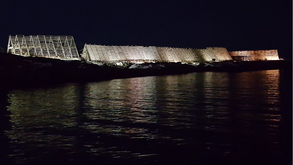
Cod Drying Racks in RorvikKristiansund at Night
On Tuesday, we arrive back in Bergen at ~2:30PM and transfer back to our Clarion Hotel. We have just enough time to shop before the stores close, and decide to eat a dinner of pizza, beer and wine before returning to the hotel for farewell drinks and deserts with our traveling group. That night is spent arranging and packing, and the next morning, it is breakfast and transfer off to the airport. Everything has gone so well that it is not surprising that KLM was now not able to check us into the flight! After an hour at the ticketing desk, they finally were able to print Boarding Passes for us, and to route our luggage to our final destination. The flights back through Amsterdam, Atlanta and New Orleans were pleasant but uneventful. This trip accomplished reaching the far north and finally seeing the Aurora Borealis – two of our long traveling desires.
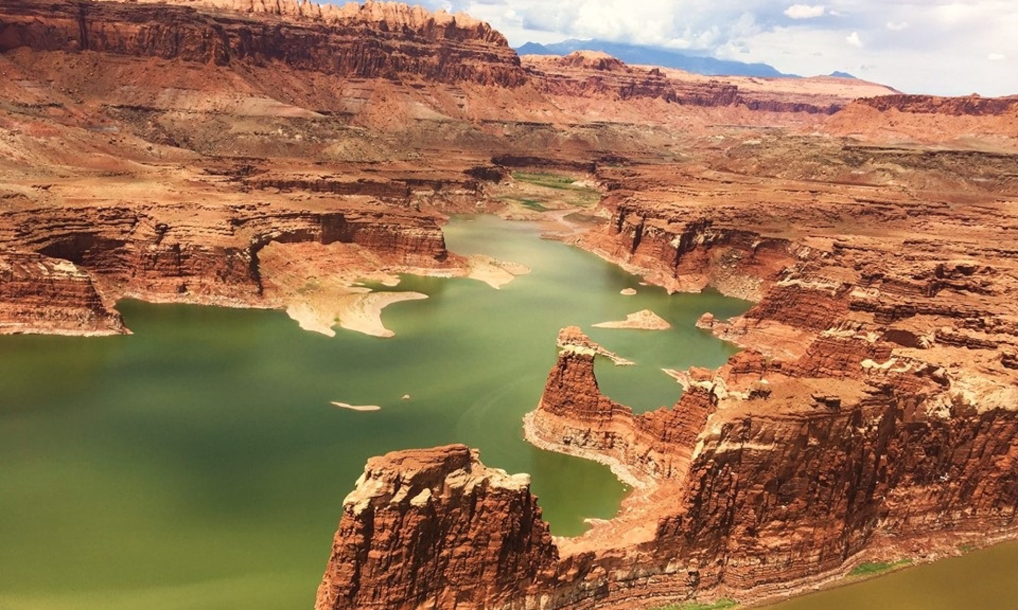
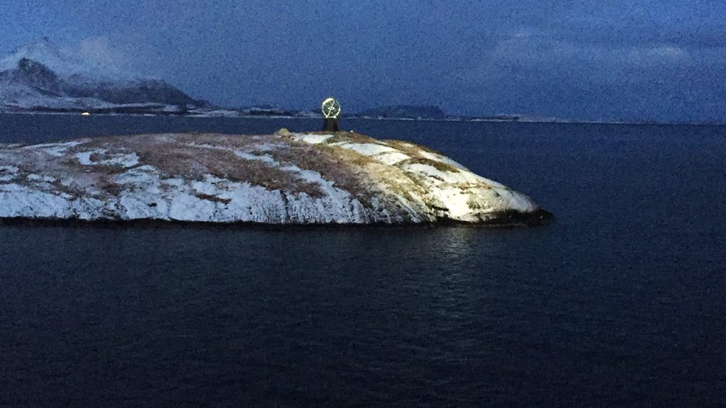
The next morning, we rise early to catch a view of the globe monument that indicates that we are crossing the Arctic Circle – the border with the” Land of the Midnight Sun”. Daylight has only recently returned to this region, and our sun is in the sky here only ~4 hours. The night has seen us experience some larger waves, and we have already had 4 short stops to unload cargo and take on passengers in the night. The Norwegians are planning a “shortcut” to our route by building a ship tunnel 75’ wide and 40’ deep that is 15 miles long under a mountain, (The Laerdal Tunnel), to be finished in 2028. After we cross the Arctic Circle, we voluntarily celebrate the “crossing” on the ship’s back deck with a toast of champagne and a “polar baptism” – the ladling of ice and ice water down one’s back followed by a shot of aquavit, all presided over by the norse god of the sea – Njord! After lunch, we docked in the city of Bodo (pronounced like budha) where we take a quick walk about in the 25 degree F weather to look at the modern, post-war Bodo Cathedral, (built in 1956), and stop into a local bar, (The Nortlaenningen Pub – which was located two stories underground), and where we all enjoyed a local beer and a little warmth. The town was founded in 1816 and only became accessible by road shortly before WWII. During the German invasion in April 1940, over 2/3’s of the buildings and homes were destroyed. Upon completing our drinks and enjoying the local hospitality, it was back to the ship (with a shortcut through the town’s indoor shopping mall), and a hot dinner with friends and family. That evening we stop and take a brief walk around the harbor of Svolvaer in the Lofoten Islands. Svolvar has the distinction of being the warmest town in the world given its degree of latitude – averaging over 35 degrees F in January & February and is home to racks of drying cod along the port’s entry!
The Globe marking the Arctic CircleThe Town of Bodo
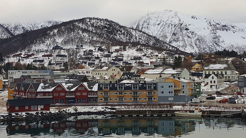
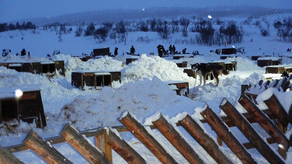
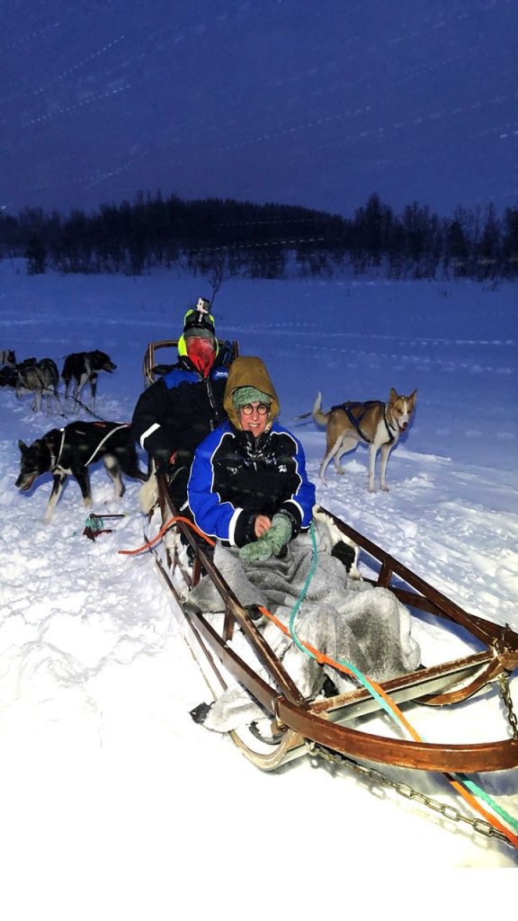
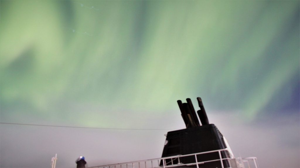
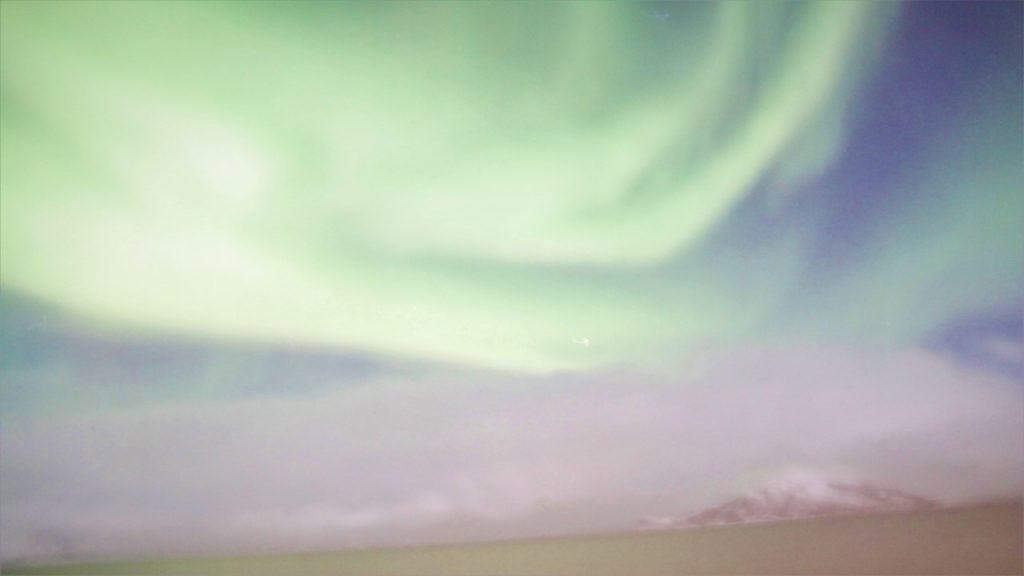
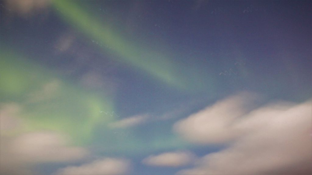
After five more stops in the night, and we arrive in Harstad early on Tuesday morning. Harstad is known for its cod and herring fishing, and for its annual cultural festival. We don’t have much time at the dock there, but we take notes and pictures for our Norwegian friends back in the States. Then we leave and make our way to the city of Tromso , the city known as “the Gateway to the Arctic” and the “Paris of the North”. Nearly every important Polar Expedition has been tied to this city, including those of Fritiof Nansen and Roald Amundsen, and the city houses the most northern University in the world. Here we split our forces, with Julie taking the afternoon city tour, and Rocky taking an excursion to go dogsledding. As the tours begin, darkness set in and heavy snows began to fall. Julie’s city tour visits the University Museum where one can create “Northern Lights” in a laboratory and with exhibits on the Sami culture and the traditions of trapping, hunting and fishing. Then it was on to the Polar Museum to learn of the exploits of the polar explorers and the history of Svalbard Island – home to the world’s largest population of Polar Bears and Walruses. Tromso is also home to the Mack Brewery which is famous for its Arctic Ale. Meanwhile, Rocky’s dogsledding adventure took him by bus to a camp where a champion professional woman dogsledder houses over 300 sled-dogs and offers 1-hour sledding adventures. We were divided into 3 groups of 12 people each, and then loaded as the first group, 2-people-per-sled. The other two 12-person groups would tour the kennels and enjoy hot drinks in the camp’s accommodations while we sledded, and the plan was to then rotate after each ~1-hour. However, while sledding through the snow with the first group, the weather degraded significantly, and the second group’s sledding was cut short and the third group’s sledding was cancelled altogether. In fact, the weather got so bad, we had to immediately board buses to insure we could make it back to the ship. However, the hour that Rocky had sledding was great fun, and the musher was a young lady from Austria who was building her personal experience. After arriving back at the ship, we set sail in a snowstorm and went to eat dinner. That night, we were treated to a magnificent show of the Northern Lights. We stood on the back deck as the skies cleared and the green electromagnetic show began. Although capturable on camera, the boat’s motion made it difficult to get extremely sharp photos. But the aerial show was spectacular! Unfortunately, by the time we arrived in Skjervoy, the city lights and growing cloud cover ended our show for the night.
Entering the Harbor of HarstadThe Dogsledding KennelsRocky and Pam on the DogsledThe Aurora Borealis over the Ship’s SmokestackThe Aurora Borealis over the Horizon
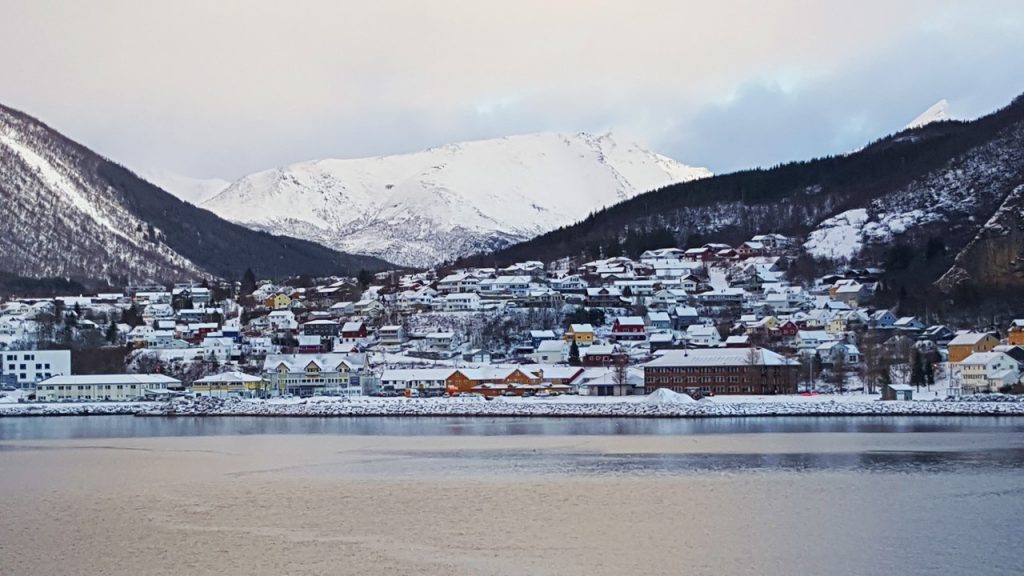
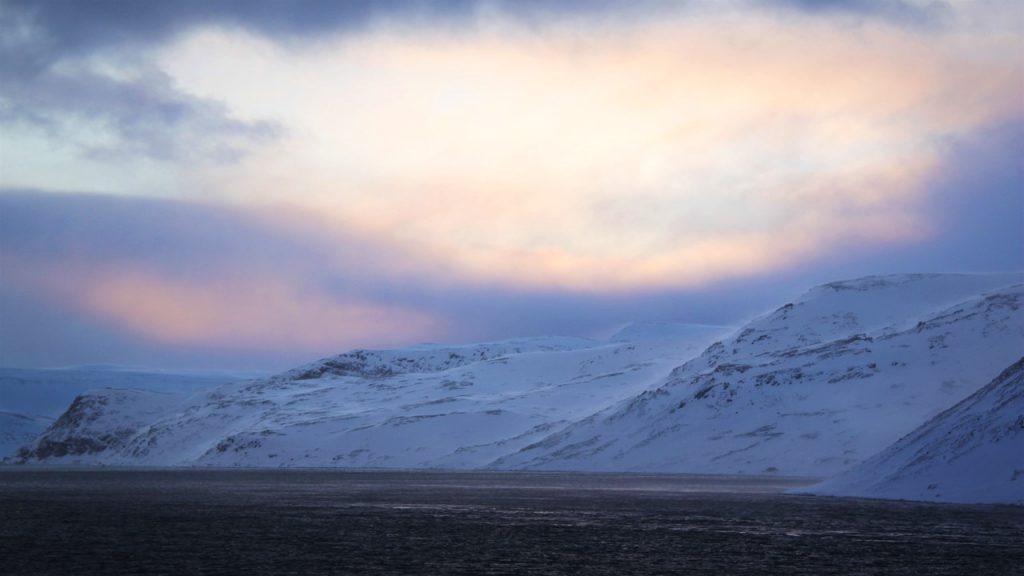
We wake on Wednesday morning with 4 new inches of snow covering the ship’s decks and icicles hanging down from the ship’s windows. The daylight is getting shorter as we travel north, and it is a “blue morning” with snow, sky and water all reflecting blue. We dock in the town of Honningsvag – the capital of the “North Cape” and home to 2800 sturdy inhabitants. Every Spring, the Norwegian Army helps transport 3,800 reindeer over the Mageroy Strait to their summer pastures on Mageroy Island, and every Autumn, the Sami herd them back to the wintering plains of Karasjok with an 1800-meter swim back. The town’s church, built in 1884, was the only building left standing after the town was razed near the end of WWII. Today the town serves as one of the northernmost cities in the world, and the gateway to the North Cape, the most northern point of any continent on earth. After a brief sightseeing excursion, we head back to the ship to round the Cape through rough wind and waves to arrive in Berlevag at 10pm, a difficult port to dock in, and the home of up to 10-meter waves directly out of the Arctic North. Today, ships can more safely access this port due to the extensive network of 15-ton concrete blocks that were set in place in 1973. Here, Julie was supposed to have joined a snowmobile excursion to travel between coastal towns, but the weather was so bad that the snowmobile excursion was cancelled. However, she was given the opportunity to try again later on the return trip back down the coast.
Morning at HammerfestViewing the Bay at Honningsvag
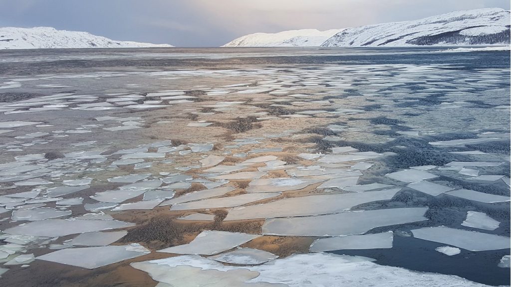
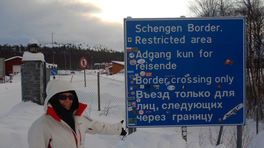
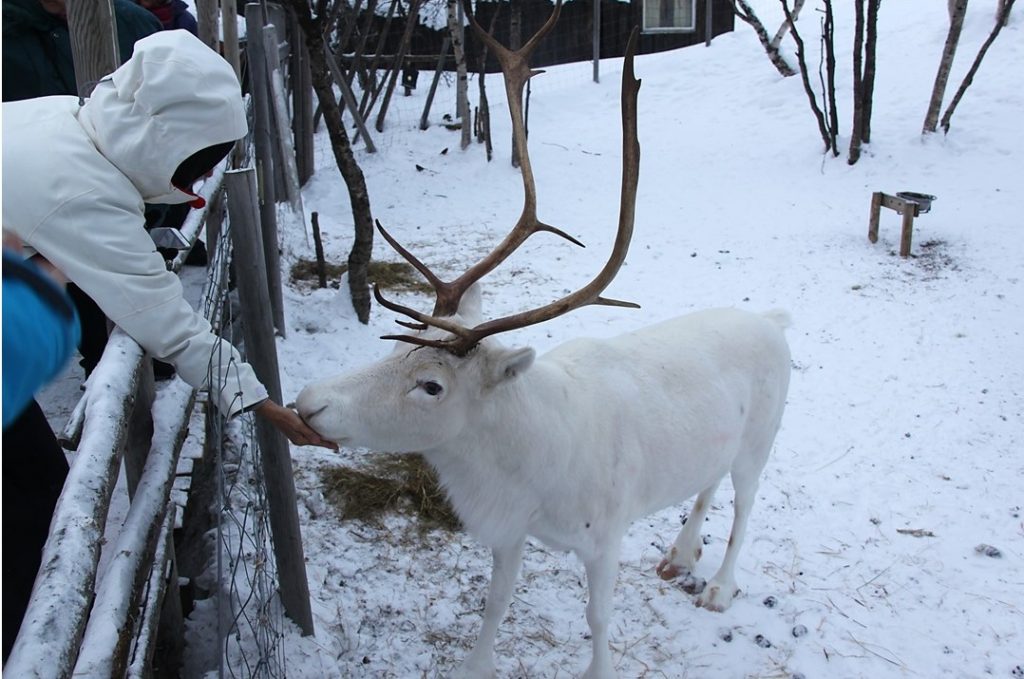
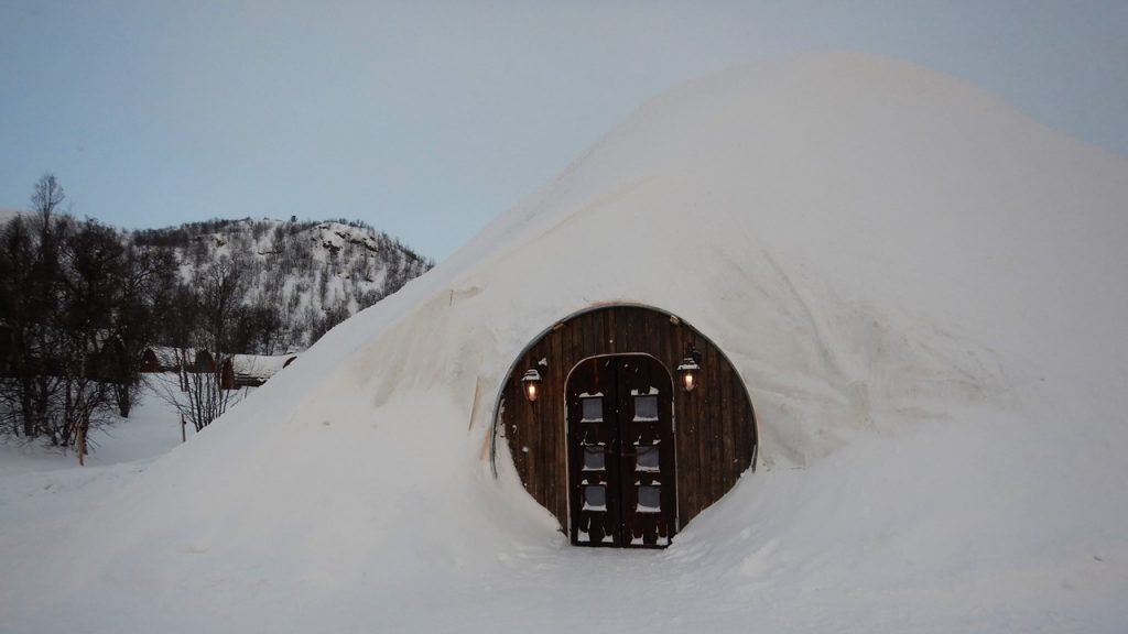
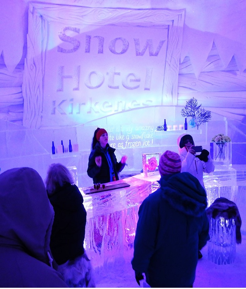
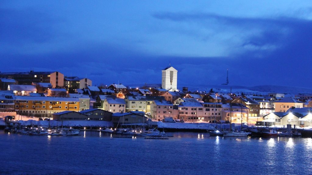
After delivering cargo in Berlevag, we begin the difficult travel back south but further to the east to Vardo, the eastern-most point in Norway, located further east than Istanbul or St. Petersburg, and connected to the mainland via a 2900-meter tunnel. Then we are on to Kirkenes (pronounced “chur ken knees”), the heart of “border country” located at the mouth of the Pasvikelva River which forms part of the border with Russia. Here we have time to explore and to take a bus excursion inland to the surrounding area and the Russian Border. Kirkenes grew up around an iron ore mining company which was a critically sought-after resource before, during and immediately after WWII. Today, the mines are idle, and the town survives on fishing, tourism and trade with Russia. During WWII, Kirkenes served as a key base for raids against the Soviets’ ice-free port of Murmansk by the Germans, and as a result, suffered 328 Soviet bombing air-raids before the Nazi’s retreated. Our bus takes us on a brief overview of the town before heading 15km to Storskog – the only official border crossing between Norway and Russia. The town has always had a vibrant but uncomfortable relationship with their neighbors to the east, but certainly better now since the “Cold War” has ended. At the border is a Sami local who runs a little souvenir shop and has a wonderful Malamute (named Bamse), that everyone wanted to pet. This part of “Finmark” which extends across the northern portions of Norway, Sweden, Finland and Russia is dominated by the Sami people. 10-15% of the Sami are still traditional reindeer herders, but the majority survive today on fishing. The reindeer are used for food, pelts, and even milk, and the antlers are even ground for medicine. After the visit to the border, we are off to the famous “Snow Hotel” – an annual seasonally-created lodge constructed from snow canons piling snow over a removable form, and then decorated by ice carvers using large ice-blocks taken from the nearby frozen lake. The hotel has 14 “snow” rooms with a reception center, and 20 additional cabins located nearby. The beds are ice and the rooms go for ~$300/night with the bathrooms located separately. The Hotel also houses a few reindeer which we get to feed, (reindeer eat lichens), and additionally have their own dog-sledding area housing ~100 dogs which we get to greet and pet. After the visit, we head back to the ship for lunch and to turn around and begin the cruise back to Bergen.
Ice filled Harbour in KirkenesKong Harald at Kirkenes HarborJulie at the Russian BorderFeeding lichens to the ReindeerEntrance to the Snow HotelAt the Reception Bar in the Snow Hotel
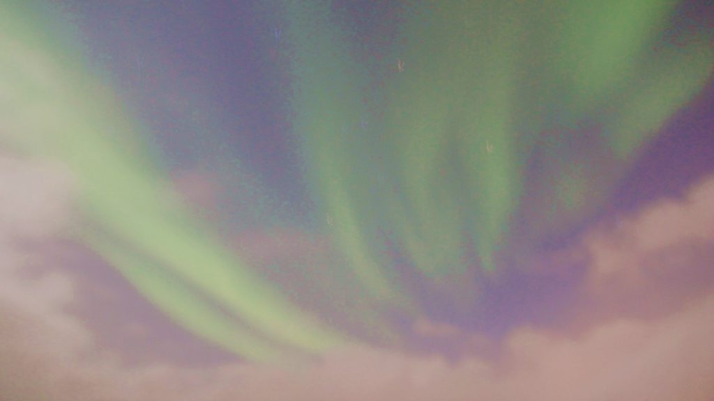
After lunch, we dock again in Vardo, and this time we have time to disembark and briefly explore the town. Vardo is the administrative capital of Finmark, and most of the people here are taught to speak Finnish. The town was completely destroyed in WWII, and like much of Norway, was rebuilt with great assistance from the US Marshal Plan. Today, the town of 70,000 make a living on fishing and public administration. After our walking tour, we re-board the ship, enjoy a dinner of reindeer, and make plans for the evening and Julie’s late-night snowmobile adventure. In preparation, she goes to bed early, but Rocky stays up and is rewarded with a modest display of the Northern Lights. Unfortunately, the 4-5-meter waves make taking pictures on deck difficult, and by the time we get back to Berlevag, the clouds have retaken to night sky and the show is over.
The Town of VardoNorthern Lights after VardoThe Aurora Borealis before reaching Berlevag
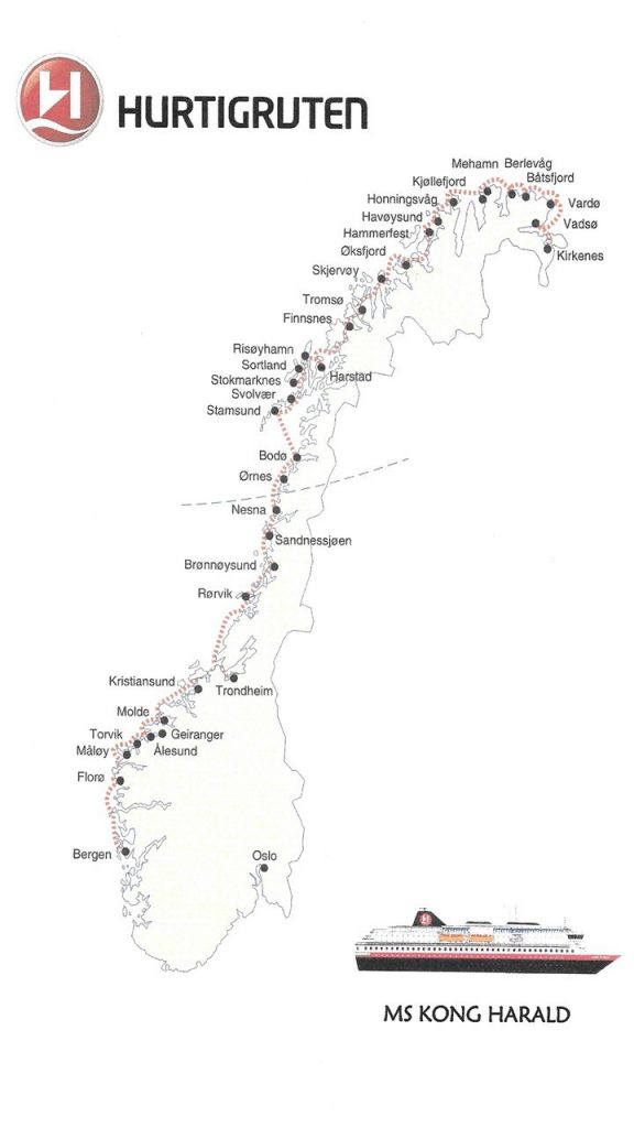
A country that we have never visited and about which we had heard great things was Norway. Norway is a country of only 5.4 million residents distributed along a string of western coastal towns that are principally located at the terminus of deep fiords. Their eastern border is defined by a range of steep mountains, the Scandes, which historically served as the natural boundary between Norway and Sweden. The northern reaches of Norway wrap around the Scandinavian peninsula to reach the border of Russia and serves as the center of the multinational region of Finmark and Sápmi – home to the indigenous Sami people best known for their seasonal reindeer herding. We also had high hopes of finally seeing the Aurora Borealis – the Northern Lights – which reach a peak in the January and February months north of the Arctic Circle.
Map of Hurtigruten Coastal Voyage
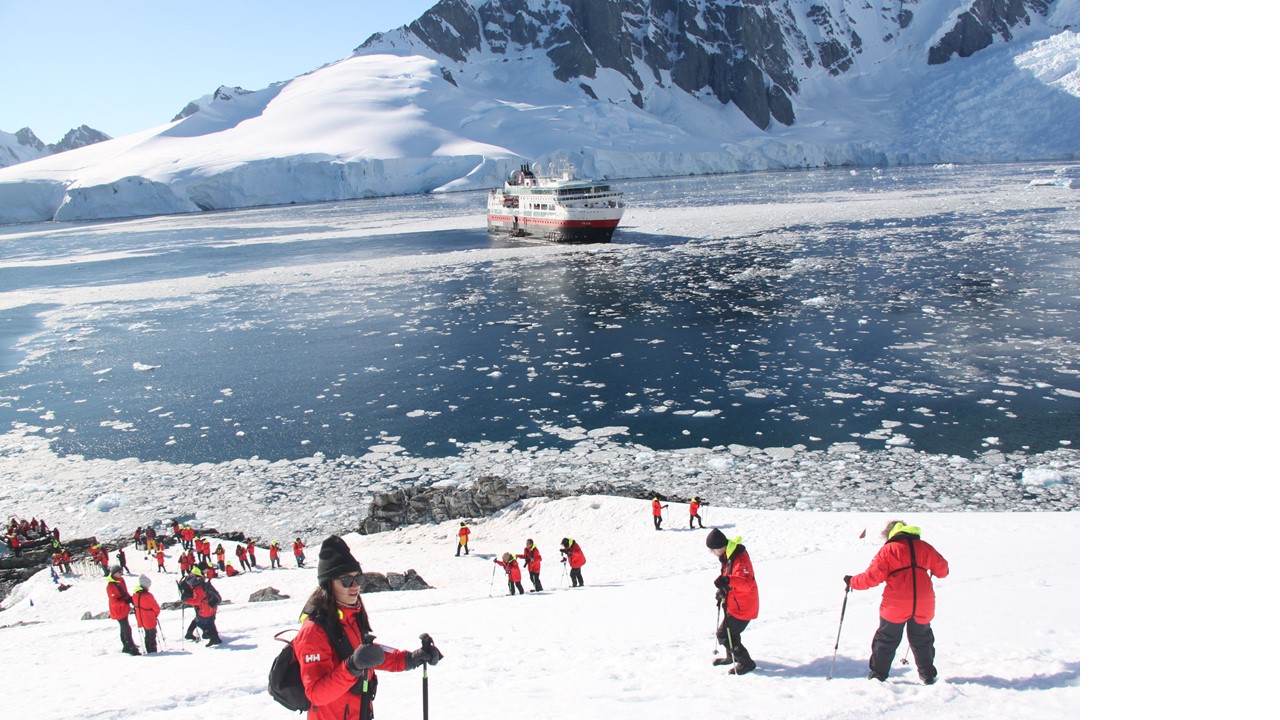
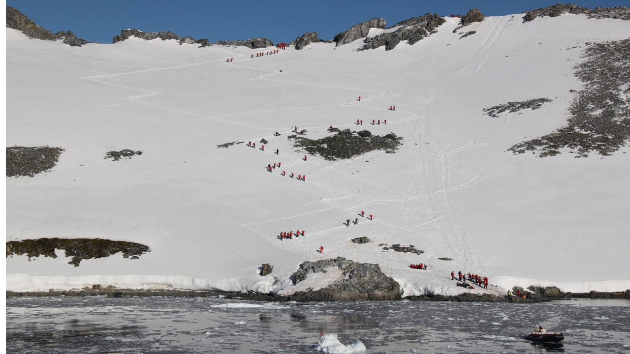
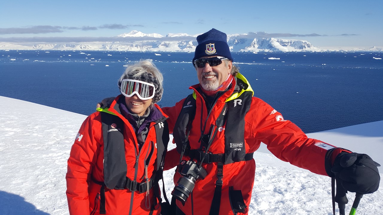
Having had a great experience on a Hurtigruten Expedition ship in Antarctica, we decided to make this adventure on a Hurtigruten Coastal ship responsible for deliveries and ferrying up and down the Norwegian coast. This would ensure that we would visit the maximum number of places stretching from our port of embarkation at Bergen in the south of Norway, all the way along the coast to the Russian border, and back – a two-week trip!
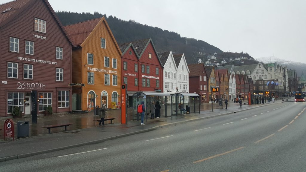
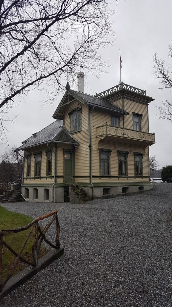
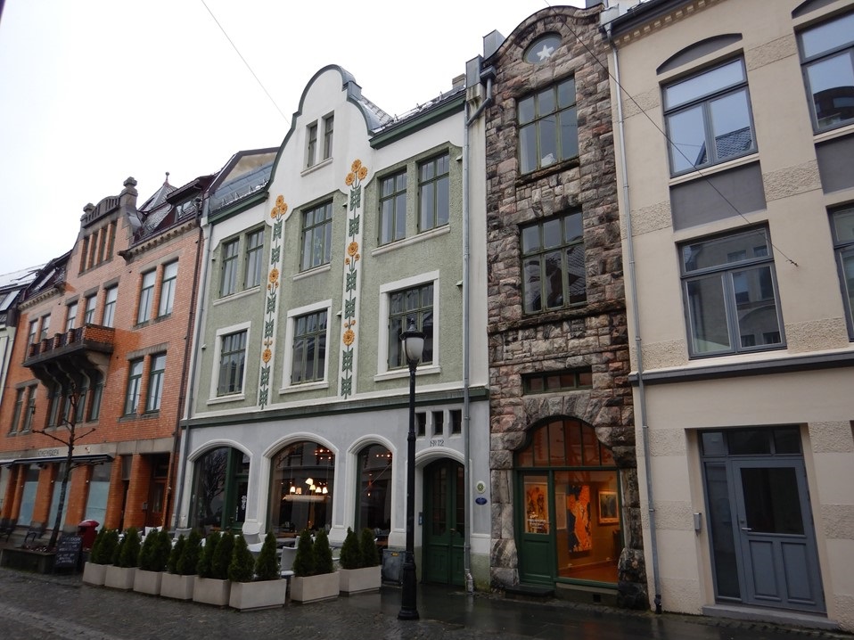
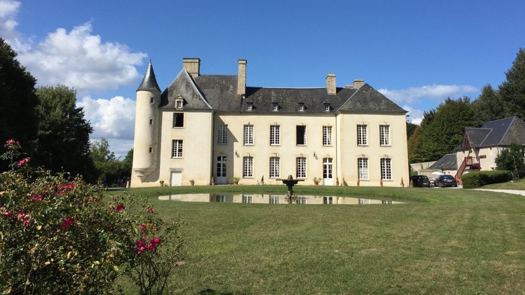
Out trip began with flights from the USA to Amsterdam, and then on to Bergen, Norway, arriving early on Thursday, January 30th. Bergen was founded in 1070 and was the capital of Norway until 1299. It was one of the most important trading centers of Europe providing transport of dried fish to the south and of dry goods to the north. The town once had 9 shipyards and 28 roperies making ship ropes until well into the 18th century. Today, the city is 180 square miles spread over a ragged coastline. Our hotel for the night was a Clarion hotel that was housed in the historic harbor shipping office building on the Bryggen wharf. The Bryggen’s historic wooden “Hanseatic” German merchant buildings located here are over 100 years-old and are built on raised wooden timbers that protect them from the occasional tidal flooding. Between each of these buildings are wooden walks that provide access to novel artisan shops. Across the street from the hotel is St. Mary’s Church, the oldest building in Bergen dating to the late 1100’s. The church was originally built for the predominantly Catholic merchants before the reformation that resulted in Lutheranism being declared to be Norway’s official religion in 1537. On the opposite side of our hotel was located the Bergenhus Fortress, the oldest fortress in Norway dating to the 1240’s which still remains under the command of Norway’s Royal Navy. That evening, we explored the wharf area including the local fish market, the shops surrounding the Vagsalmenningen Square, the Galleriet Mall and the local Starbucks, weathering the light rain. After dinner at the hotel, we took advantage of the view from the hotel’s historic 100ft-high tower before making plans for our day tomorrow and calling it a night.
Bryggen Buildings of Bergen Wharf
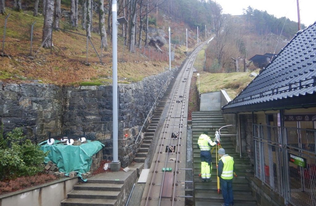
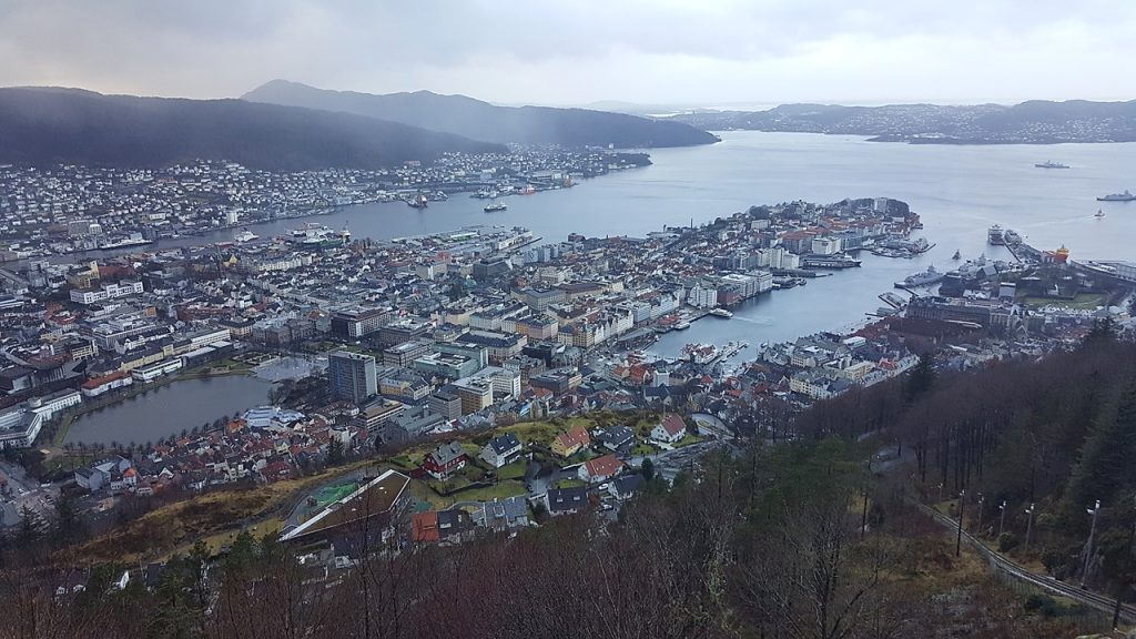
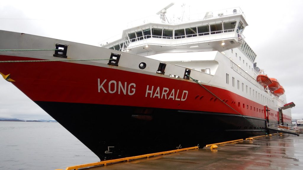
Friday morning began with an early breakfast at the hotel before embarking on a walk to the town’s funicular that would transport us up Mount Floyen which towers above the city of Bergen. The funicular appears to be both electric and cable driven as it hauls us up a steep grade through tunnels, under roads and up the mountainside, including stops at two small housing areas. Once at the top, we enjoy the spectacular views and examine the old funicular components before deciding to take on the long walk down. During our walk, the rains begin again in earnest. Bergen is known as the rainiest city on earth averaging 240 days of rain per year! This is a result of the moist air riding above the North Atlantic Current coming from Great Britain and dropping its rain as it encounters Bergen’s mountains. After finding our way back to the hotel, it was time to check out and take a brief bus tour of the area. After viewing various areas of the city, we headed out into the country to the little town of Troldhaugen – a suburb of Bergen and the former home of Norway’s most famous composer Edvard Grieg. Today, his home and study host a museum dedicated in his honor. After spending time learning more about his life, we re-boarded the bus and headed to our accommodations for the next two weeks – the Hurtigruten ship “Kong Harald”. Once settled, we enjoyed a buffet dinner and preview of the week before casting off at 9:30pm to begin our cruising adventure north.
The Mount Floyen FunicularView of Bergen from Top of Mount FloyenComposer Edvard Grieg’s House & MuseumOur Coastal Ship – The MS Kong Harald
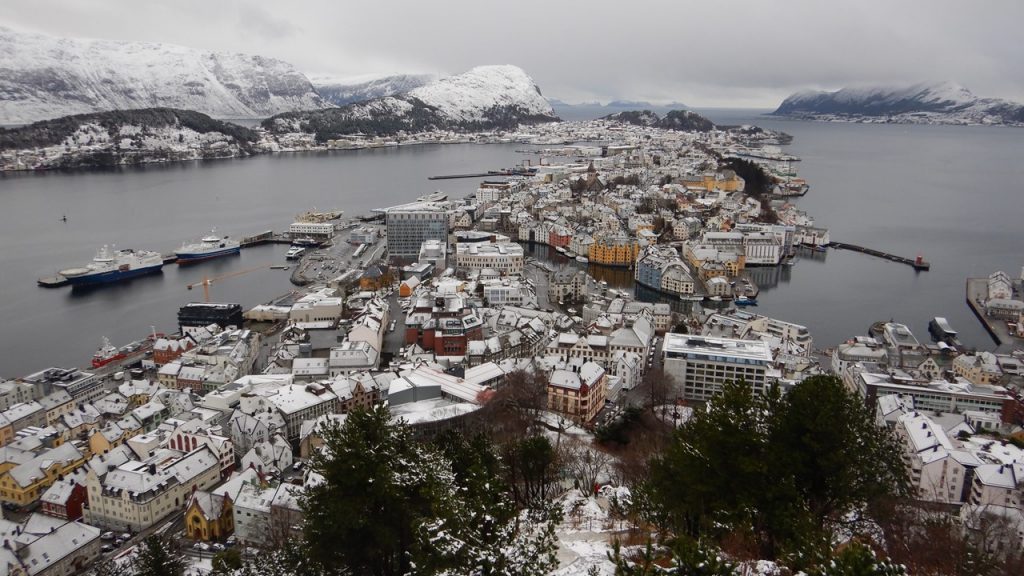
After 3 very brief stops in the night, (this coastal ship serves as a delivery ship and passenger and auto ferry, as well), and our first few hours at the mercy of the open seas, we arrived the next morning in the town of Alesund. Alesund sits near the mouth of Norway’s longest fiord and was rebuilt in the Art Nouveau style after the town’s wooden structures burnt to the ground in 1904. After a brief tour of the harbor and along the town’s cobbled streets, we climbed the 418 icy steps to the top of Aksla Mountain for spectacular views of the town and surrounding area and then walked down the winding path along the peninsula through 4” of freshly fallen snow. Along the way we passed statues of Rollon-Gange Rolv, the founder of Normandy and Kaiser Wilheim II who often visited the area, finally making it back to town in time to shop before re-boarding our ship.
The Art Noveau Architecture of AlesundAlesund from the Fjellstua Viewpoint
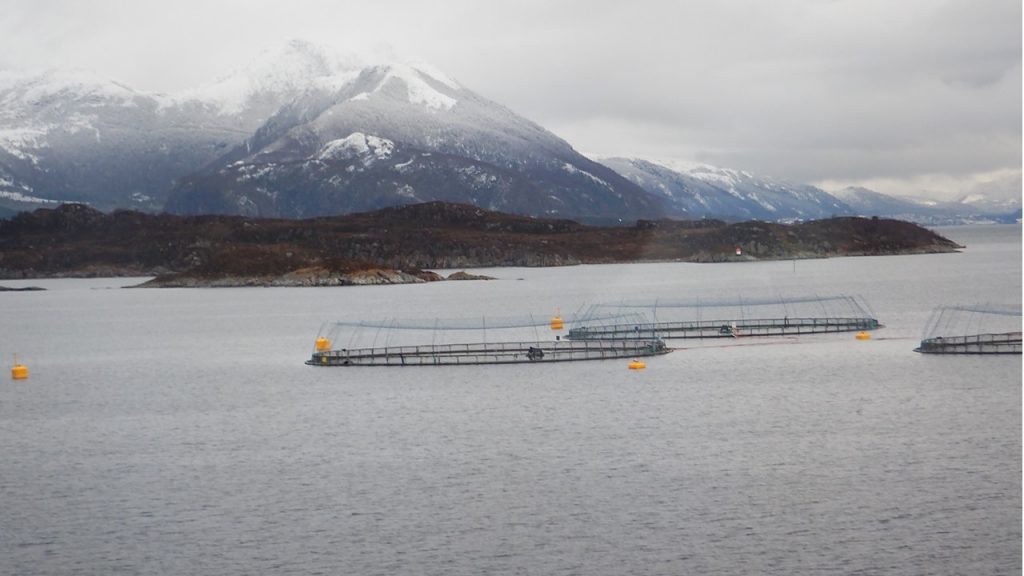
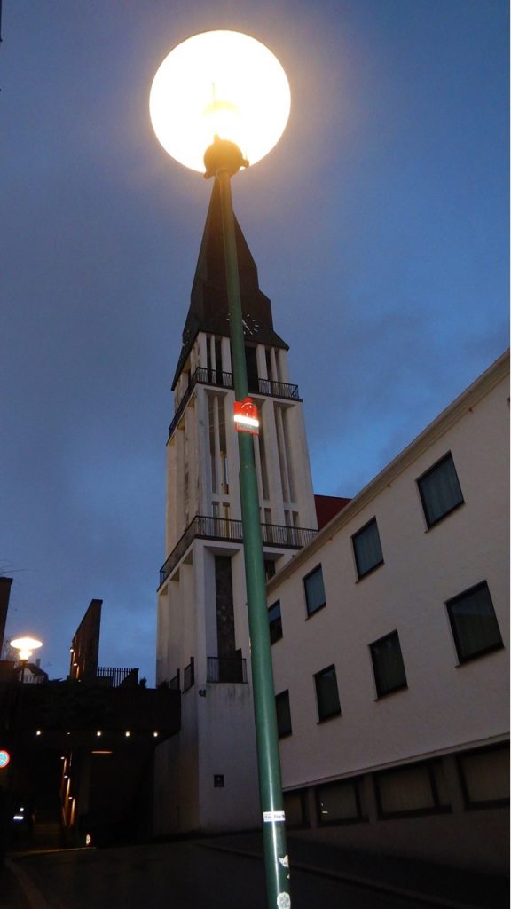
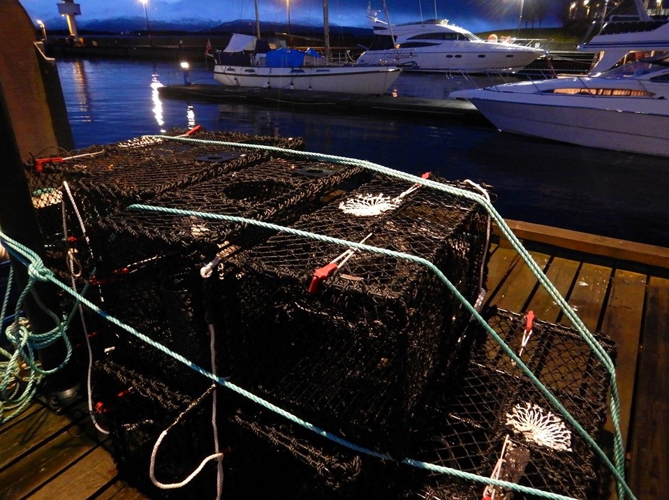
Our next port that afternoon was Molde – the “City of Roses”. Molde was extensively destroyed in WWII as the German Army leveled and burnt the town on their retreat at the end of the war. Today it serves as a popular summer-home location for wealthy residents and includes a brand new boardwalk and the 13,000 seat Aker soccer stadium as home for their local professional team. After dinner onboard, we have a chance to briefly explore our next stop at Kristiansund – a harbor town spread over three islands dating back to the Middle Ages. We checked out the monuments to ships and sailors before making a short trek to the local Kristiansund Church. It was night and the streets were empty, so we headed back to the ship for a night’s sleep and voyage.
Fish Farms on the Way to MoldeStreetlight over Kristiansund CathedralCrab Traps on the Docks at Kristiansund
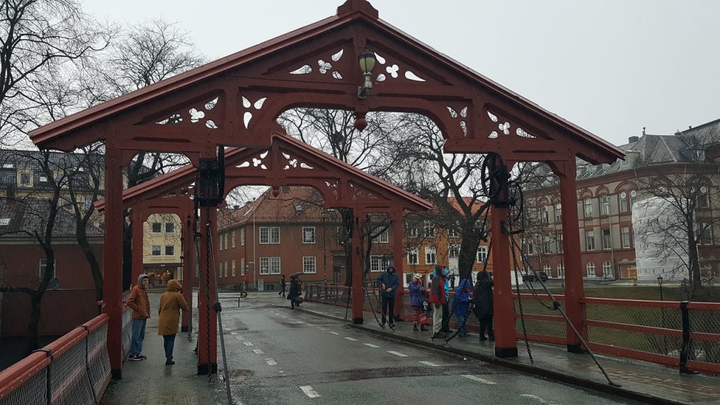
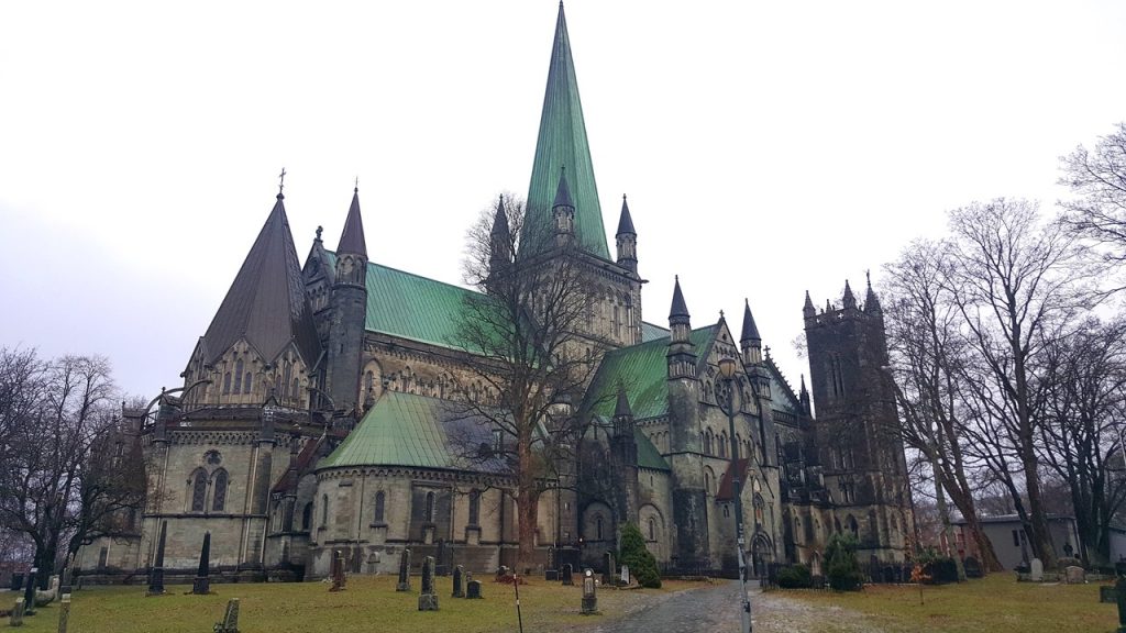
It is Sunday morning when we arrive in Trondheim, formerly known as Nidaros (“mouth of the river”) and Norway’s first capital from 872 until 1217. Leif Eriksson completed his military service here and the St. Olaf Shrine located here still attracts legions of pilgrims. Nidaros served at the religious center of Norway, and the seat of the archbishop diocese until the reformation in 1533. The city is Norway’s third largest (175,000 people) and is built around the River Nid (Nidelva) which snakes its way through town. After arriving, we board a bus for a “city tour” that climbs to an overlook before heading to a walk on the old Town Bridge. Most of the city was rebuilt after the great fire of 1681 destroyed much of the town. After visiting the bridge and marveling at the old, wooden warehouse buildings built on pilings along the river, we walk to the nearby Nidaros Cathedral – one of Northern Europe’s greatest Gothic memorials. Since it was Sunday, we had to wait in the Visitor’s Center until the Church Service was over, but by then, it was pouring rain outside, and so we entered the cathedral via an underground entrance through the crypts. The crypts are still populated with a mix of Norse, Catholic and Lutheran tombs and markers, many of which are not yet fully examined. The cathedral is spectacular with 3 separate organs, each from different eras (1200AD, 1600AD, 1900AD) which includes over 12,000 pipes in total. Next we toured the central part of the city including the University and the old Kristiansten Fortress. After leaving Trondheim, we cruised past Munkholmen, an islet lying just offshore that served as a Middle Ages monastery. Today it is a recreational center for families and visitors during the warmer months.
Trondheim’s Old Town Wooden BridgeThe Warehouses along the Nid River in TrondheimThe Nidaros Cathedral in Trodheim
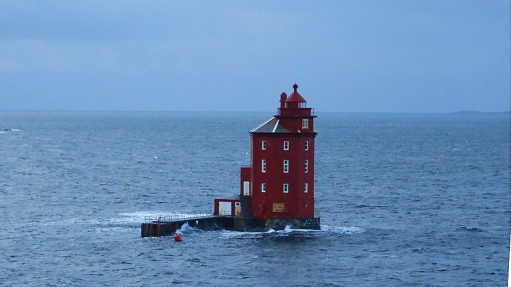
As we cruise along the coast, we pass many islands (including tens of thousands of “skeeries” which are islets too small for inhabitation) including the Kjeungskjaer Lighthouse, (the “red sailor”), which somewhat recently housed a young family with 5 children who would sometimes need tethering when playing outside given the waves and winds that are experienced there. Many of the larger islands are connected via tunnels and bridges (over 19,000 of them), most of which were built after the discovery of oil offshore on Christmas Day in 1969. Today, Norway is the 7th largest producer of hydrocarbons in the world, but nearly all of it is exported. 98% of Norway’s domestic power needs are met from hydroelectric plants which are scattered across the country. That night we learn more of Norwegian history and the origins of the legends of trolls. As we continue to travel north, the chance of seeing the Aurora Borealis increases, and we bed down for the night with our room intercom set to wake us should they be spotted while we sleep.
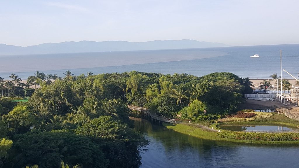
Our close friends, Bob and Diana, kindly invited us to join them for a week at the Vidanta Resort located on Mexico’s west coast near Puerto Vallarta on Banderas Bay. The Saturday flight to Puerto Vallarta is an easy one connecting through Houston, Texas, and the airport exit is the typical chaos of hawkers, salespeople and taxi drivers. This weekend is the annual “Day of the Dead” festival, and tourists are crowding the small facilities. We finally found our way to our transport to the resort, which required entrance through an impressive security gate and passage through miles of meticulously gardened roads. Apparently, the resort owners are terra-forming the many acres of reclaimed ground into a mini-Disneyland of Mexico’s west coast. The resort itself is huge with multiple timeshare, hotel and condominium buildings, numerous restaurants, and a half-dozen pools, including swim-up bar, a lazy river, wave pools and cabana service. We checked-in, drank our complimentary margarita, met up with Bob and Diane, and made our way to our 6th-floor, two-bedroom suite in The Grand Bliss, a central building overlooking a pond, a pool, the beach and Banderas Bay. The suite included a complete kitchen, 2 ½ baths, a balcony and a private plunge pool! All the facilities and amenities at the resort are connected by walkable paths but can also be accessed via a complex golf cart transportation system, as automobiles are not allowed into the guest areas. Dinner was at Epazote restaurant where we dined on traditional Mexican fare, including guacamole made fresh at our table-side. That evening, we enjoyed fireworks over the Bay, and prepared a plan to explore the next morning.
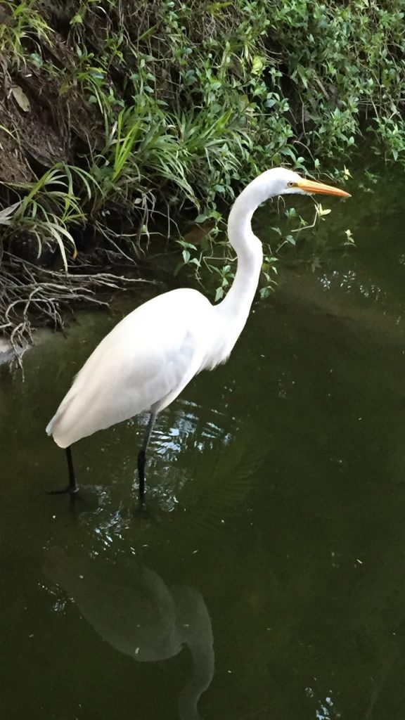
Local egrets (Nivea Garza) wandering the extensive gardens.View from the Suite’s balcony of Banderas Bay.
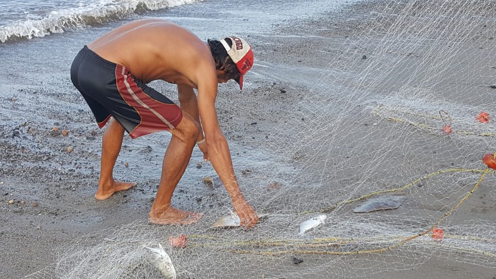
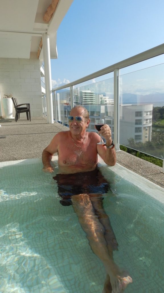
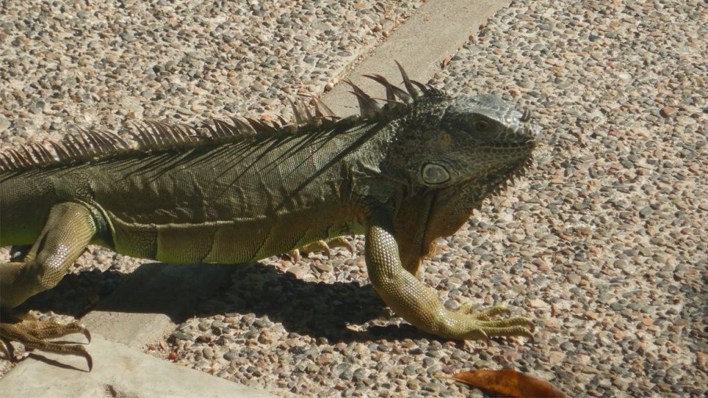
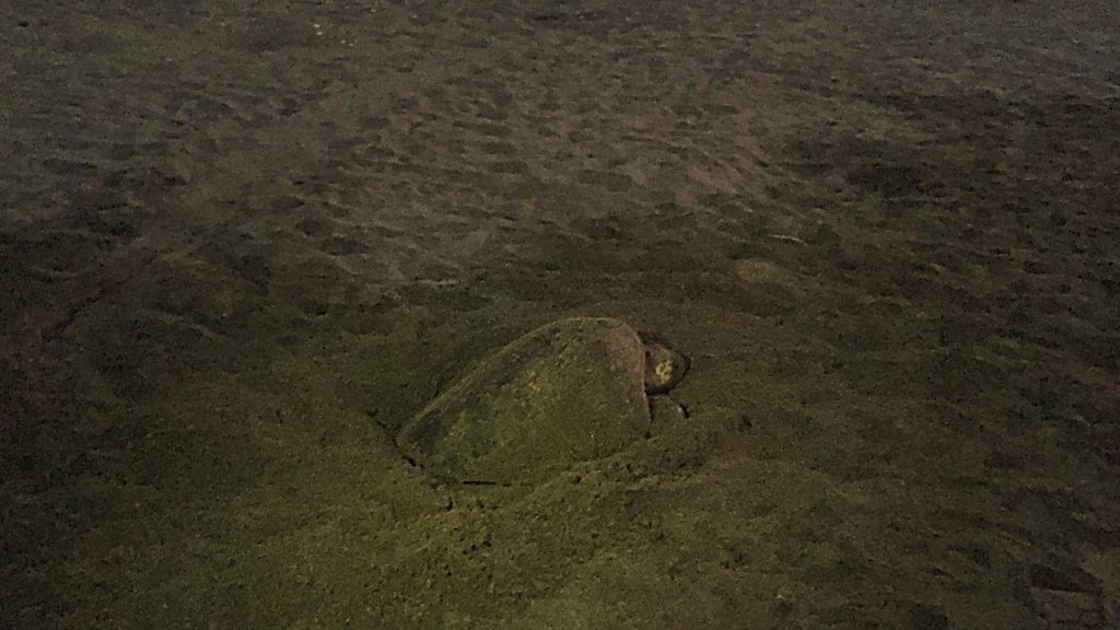
Sunday morning, we were up early for a walk on the beach where we saw many tracks from active Olive Ridley Sea Turtles nesting during the night. At the southern end of the resort, there is a point of land where the Ameca River flows into Banderas Bay, and it was populated with numerous local fisherman casting from the beach. On the way back, we watched two local men swim their gillnet through the surf and manually haul it in, reminding us of similar fishing techniques that we watched local tribes do in Nigeria. As the sun rose over the mountains to the east, we watched the many dolphins playing and eating just offshore before heading back to get breakfast. After consuming huge crepes at the Sweet Paris Creperie, we walked to the resort’s local grocery to stock-up on water, wine, rum, cheese and snacks. Then it was off to the Concierge to book any tours that we wanted to do later that week, which would include a trip to the town of San Sebastian, and an excursion offshore sport fishing. Then, it was off to one of the swimming pools for a relaxing afternoon of reading and margaritas. Julie and Bob took a couple of trips around the Lazy River, where they enjoyed waves from the wave machine, while large 3-foot-long Green Iguanas along the way took little notice of them. After pool-time, we all headed up to the suite for a dip in the plunge pool and a glass of wine, before getting ready to head out for dinner. That night we dined “french” on lobster, escargot, and scallops at the Azur Restaurant, which we finished off with an excellent crème brulee.
Local fishermen with mornings catch.Relaxing in the suite’s plunge pool.
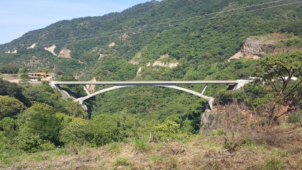
Monday morning, we had a light breakfast at the suite, before meeting our bus for our excursion to San Sebastian. San Sebastian del Oeste is a town 60 miles from the resort located high up, (over 1-mile in altitude), in the mountains. The town was founded in 1580, and at one time was home to over 30,000 people – most making their living from the vast silver mines located there. During the revolution of 1910, the mines were blown up, and the town has shrunk to less than 1000 people today. Their economy is now principally driven by agriculture and a growing tourism business. Until relatively recently, the trip to San Sebastian would have taken many hours over dirt and gravel roads and old river crossings. Today, the road is paved, and a new bridge crosses the principal river gorge making the trip only about 90-minutes. Along the way, we stopped at Raicilla de El Nogalito de San Sebastian, a local family-run tequila maker that only makes small runs of tequila monthly from their locally grown blue agave plants. There, we tasted Blanco, Reposado and Areanas tequilas, and tasted their local flavored blends, including our favorite – coffee. We then traveled to the edge of the town, San Sebastian, where we stop to explore a local coffee plantation – the Café de Altura La Quinta. This small plantation (~12 hectares) has been operated by the same family for over 100 years, originally founded by a Spanish settler who married a native woman. The coffee trees are shaded by an extensive fruit orchard that towers over them, providing both the right amount of sunshine and the necessary soil nutrients to be successful. After exploring and tasting their coffee, we walk into the town of San Sebastian, where the building and stone cobble streets are still original from the 19th century. Access to town for the surrounding population was principally still via donkey carts until 2010. We stop for lunch at a local restaurant, “Jardin de Ninos”, where we have a fantastic traditional meal of quesadillas, machaca, chicken mole and refried beans. After lunch, we walked into the town’s center looking at the pre-revolution architecture, including the old silver company store, the jail (still in use) and the church. After free time to explore and shop, we board the bus for the trip back to the resort, go for a quick walk on the beach where we watch the “Fiesta Mexicana” show and firework. That night we relax at the suite enjoying drinks and a light dinner.
New bridge across river gorge on the way to San Sebastian.Blue Agave – the principal source of Tequila.The quaint still used by the local family for tequila.The streets of San Sebastian.San Sebastian Old Town SquareInside the San Sebastian Church.
On Tuesday morning, Rocky arose early to try his luck fishing from the beach but only caught two small stingrays. After a light breakfast, we assembled at the pool for another relaxing day. From 11am until 3pm is “happy hour” at the swim-up bar, and we take advantage of the 2-for-1 drinks, cooling off from the sun with frozen margaritas. We both decide to ride the Lazy River before coming back for a poolside lunch of mussels and quesadillas. After the restful day, we had dinner on the beachside restaurant, “The Havana Moon”, where we enjoyed Cuban preparations of salads, shredded beef and barbequed pork ribs.
Julie on the Lazy River.
Wednesday morning gave Rocky another chance at fishing from the beach, but with no success at all this time. However, the early start did offer the chance to see one Ridley Turtle finish laying her eggs and make her way back into the sea. The Olive Ridley Turtles are only ~18” to 2’ long, and their nests are very shallow, making them easy targets for predators such as birds and racoons. After returning to the suite to clean-up, we all headed to a complementary buffet breakfast at The Café Largo Restaurant. This was an appointment scheduled for Bob and Diana to review their current membership status, but the breakfast offered some of the best empanadas and Mexican treats that we had had. After breakfast, we headed to the pool and “happy hour” for the rest of the day before making reservations for a traditional Mexican dinner at La Cantina. This novel sports bar boasts stools made from horse-riding saddles and traditional décor and food.
Mexico’s Green Iguana – about 2 1/2 feet long.
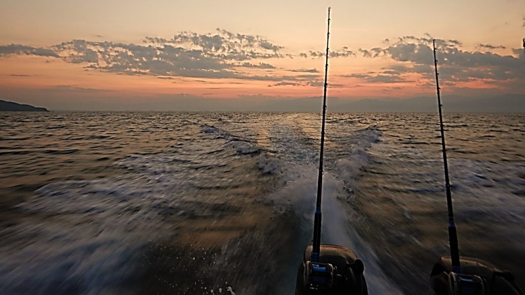
Thursday morning, we were all up early to catch our taxi transport to Paradise Village Public Pier for a day of sport fishing. At the pier, we were met by the captain and first mate of the “Luky”, a twin outboard sport fishing boat. As we motored out into Banderas Bay, the weather was good, and the seas were calm. By the time the sun started showing over the eastern mountains, we had motored west ~20km to a point near Destiladeras where we began fishing for bait and potential lunch. While there, Rocky caught two Spanish Mackerel and one Skipjack, Diana cause a Spanish Mackerel and Yellowtail, Bob caught 2 Spanish Mackerels at one time, and Julie caught a Spanish Mackerel, as well. With these fish and others that the first mate both brought and caught, we continued our journey to the southwest to get beyond the bay and into deeper, cooler waters where mahi and billfish might be caught. With seven lines out at various distances, we fished for the 4-hours past the Marietas Islands and all the way across the outer edge of Banderas Bay, however, we never got a bite. As noon approach, the first mate cleaned and filleted several of the mackerel, and made an outstanding ceviche, which we ate with chips for a delicious lunch. As afternoon began, we headed back to the port, stopping briefly to watch the frolicking dolphins that came to investigate us. After returning to the resort, we went for a walk on the beach, explored the Turtle Nesting Nursery, and spend some time at the pool. Dinner that night was via “room service” where we had steak and fajitas and watched a movie, “Deja Vu”, in Spanish on the television.
Sunrise from out on the water.Fishing in Banderas Bay.
On Friday morning, Rocky again tried his luck fishing at the beach, but again with no luck. Julie came down to encourage him and to explore and got to witness not only a nesting turtle, but also the release of baby turtles back into the sea from the Turtle Conservancy located there. They have a regular program where they collect turtle eggs from their beach nests, rebury them in a protected area, and then release them into the sea when they hatch. After our morning beach excursion, we headed to “Sweet Paris” again for a crepe breakfast, and then again spent the day poolside before making reservations at “Gong”, an Asian-style restaurant. Here we had one of the best tempuras we’ve ever tasted and complimented our meal with dumplings and red wine. Then, it was back to the suite to pack for our journey home the next day.
Saturday was “travel day”, but, after arriving at the airport, we were excited to discover that part of our trip we were upgraded to first class. This was a great way to conclude a fantastic and relaxing week.
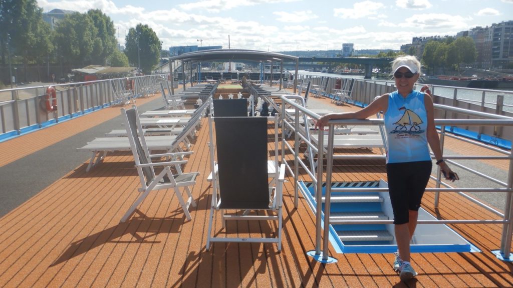
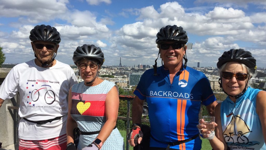
After four sightseeing-filled days in Paris, Thursday morning, August 29th, 2019, saw us meeting our bicycling travel group in the lobby of the Balmoral Hotel. The 23 of us were met by two of our four Backroads Guides, Otis & James, and we proceeded to load our luggage and ourselves onto a large motor-coach and head west out of the city to a farm where we were fitted to our bikes, received a safety lecture, and began our first ride to Versailles for lunch. Of the 23 in our group, 12 had e-bikes (battery/electrically assisted), and 11 had “regular” bikes. Now, by “regular” bikes, I mean Backroads’ custom titanium and carbon-fiber-frame bikes with electronic shifting! Bikes that are certainly well out of my price-range to purchase! In our little group of four, the two boys were on regular bikes, and the two girls had e-bikes. The ride to Versailles was short (~9-miles) but was a good chance to get used to our bikes and make sure everything was okay. Unfortunately, not everyone had as smooth of a ride as we did, and a few spills and bruises were already collected. Lunch was in the gardens of Versailles, very much near where we ate lunch during our visit two days before. After lunch, we rode another 8-miles through a national forest and a state park to a viewpoint overlooking Paris. From here, we could see the landmark weather balloon that rises over Paris daily, and were informed that our Riverboat was located at the base of it. For those who chose to do so, we rode the additional 8-miles into Paris – dodging the tourists and pedestrians – and making our way to the wharf where the AmaLyra was located. For those who chose to take the van from the overlook, wine, beer and snacks were readily available. Once there, Backroads retook possession of our bikes, and we checked into our lovely upper-level staterooms, complete with balconies and sliding glass doors. After showers, we toured the decks of the ship before meeting in the lounge at 6:00pm for “Welcome-Aboard” drinks and meeting the Captain (“Jackie”) and crew. Our Captain was from Romania, was 32 years old, and had “cut his teeth” on tugs and commercial boats. This would be his first voyage as Captain of this riverboat! Most of the crew was either French, Romanian or Portuguese. There were ~120 passengers on the boat, and our group, the most adventurous aboard, numbered 25 in total with our guides. Dinner was in a lovely dining room and included free-flowing wine and beer. After dinner, we all went up on-deck to say good-bye to the lights of the city, to observe the wheelhouse move up and down to fit under bridges, and to get to know our fellow passengers. That night we socialized on-deck until ~11:30pm and enjoyed the French wine and the beautiful warm summer evening.
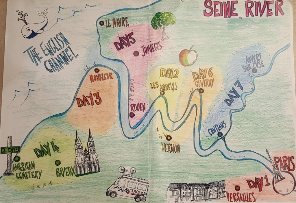
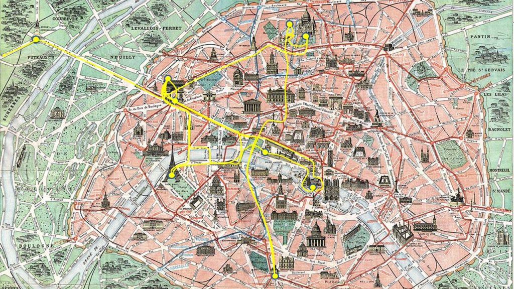
James’s Map of our Bicycling Adventures in FranceJulie on Deck of our Ship – The AmaLyraOur Family of Adventurers
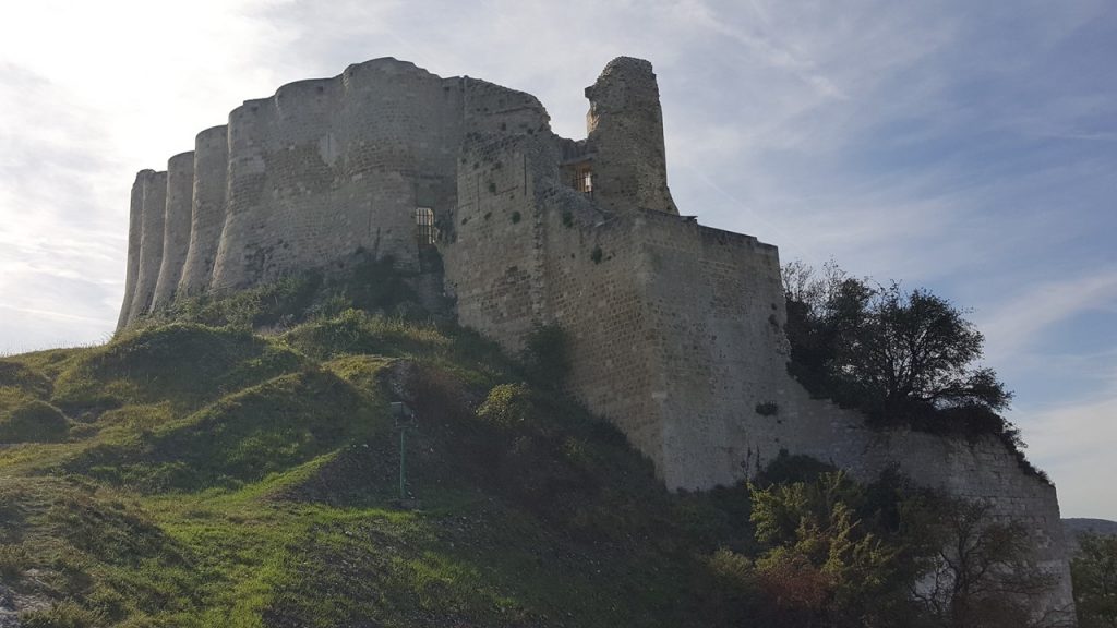
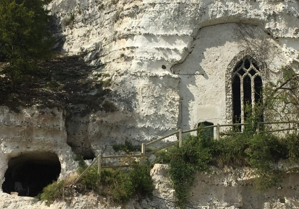
Friday morning, we arose at 6:30am for breakfast, and then disembarked the boat in the town of Vernon. Here, we met our other two Backroads Guides, Carlos and Clem, and boarded our bikes for a 13.4-mile ride to the town of Les Andelys. As we began, the boat left to join us downstream. After getting out of the town’s traffic, the ride was quiet and pleasant along parts of the Seine River and through the local countryside. Upon arriving in Les Andelys, we grabbed a couple of snacks and had the option to either ride a 19-mile hilly loop back to town or take a guided tour of the ruins of Chateau Gaillard – the castle stronghold of Richard-the-Lionhearted. Rocky took the tour while the other three of our group rode the loop. The loop started with a 450-foot high hill and a gently rolling ride through the countryside. The tour of the castle was led by Natale and explained that this large portion of what is today, France, was once ruled by Richard-the-Lionhearted, who was simultaneously King of England and feudal Duke of Normandy. In the 1180’s, The King of France struck and alliance with Richard to join the Crusades to free Jerusalem. While Richard was gone, his brother, Prince John would rule in his stead, (remember the stories of Richard, Prince John and Robin Hood!) After battling at the Crusades, the King of France returned home to France, and began to make a deal with Prince John for annexing Richard’s lands. The immensely popular Richard arrived back in time to stop the transfer, but decided that the French could not be trusted, and set forth to build a fortress castle on the banks of the Seine to give warning to any French attack from Paris. The castle was built high on the limestone cliffs above Les Andelys and used a novel design of curved walls that was a learning of Richard’s from his failed assaults in Jerusalem. Construction began in 1196 but was competed in just two years in 1198. Château Gaillard has an advanced design and uses early principles of concentric fortification. The castle consists of three enclosures separated by dry moats, with a keep in the inner enclosure. Unfortunately, in 1199 Richard was wounded in Limoges by an arrow to the shoulder from which he subsequently died, and the region slowly fell under strong French influence. Château Gaillard was captured in 1204 by the king of France, Philip Augustus, after a lengthy siege. In the mid-14th century, the castle was the residence of the exiled David II of Scotland. The castle changed hands several times in the Hundred Years’ War, but in 1449 the French king captured Château Gaillard from the English king definitively, and from then on it remained in French ownership. Henry IV of France ordered the demolition of Château Gaillard in 1599; although it was already in ruins at the time. It was designated a “quarry” and many of its stones were taken and used to build the local towns and villages. From here, the tour visited the town of Les Andelys, and the flying-buttressed church that anchors the town. After the tour, and upon the return of the loop-riders, we were visited by Madame Micheline and Monsieur Jaques Renaut who offered us the opportunity to taste some authentic Normandy treats. We started with their homemade “pommeau” – a sweet apple liquor and enjoyed a 100-year-old recipe for a neufchatel cheese and savory bacon-pea muffins. After that, the Amalyra was ready for us to re-board in time for a lunch of escargot and baked trout. The afternoon was spent cruising down the Seine through a series of locks. Before dinner, our Backroads group met at the Chef’s Table Room for wine and cheese and individual introductions, and then adjourned to dinner and a night on the dance floor.
Chateau Gaillard – The Stronghold of Richard-The-Lionhearted
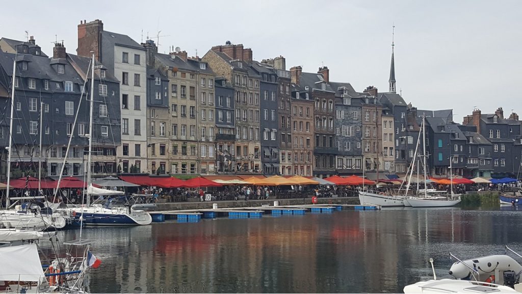
Saturday morning, the ship arrives and docks in the port city of Le Havre and moors at the Quay of Marseille. Le Havre was completely destroyed by the Allied Bombing of World War II, but today is completely rebuild with innovative uses of concrete. We get to sleep-in as we meet with our group and disembark at 9:30am. From here, we take a short bus ride to the other side of the estuary where we board our bikes and ride 9.1-miles west through the countryside of Marais Vernier past thatched-roof houses to a small coffee shop operated by a southern French lady with Spanish ancestry who you would not want to cross! But she makes a spectacular cappuccino! From here, we ride another 6.1 miles to La Cremaillere where Monsieur and Madame Delaunay welcome us for lunch. We are served a delicious fish with carrots and broccoli, finished off by an apple tart and apple gelato. After lunch, we continue our ride for another 11.8 miles to the colorful port city of Honfleur, located downstream and across the estuary from Le Havre at the mouth of the Seine River. Upon arrival, we are met at the Quay with oysters on the half-shell, wine and snacks. Once our group is all assembled, three of us decide to tour town instead of riding the optional additional 14-mile loop. The old port is picturesque with shops and restaurant, an antique merry-go-round, Ferris wheel, and all the enticements of a tourist’s mecca. The Sainte-Catherine church, which has a bell tower separate from the principal building, is the largest church made from wood in France. Honfleur, with no significant targets, was bypassed from the Allied bombing during World War II, and thus survives in its old beauty. We sightsee, shop and enjoy some chocolate crepes before catching the bus to cross the estuary and re-join the ship in Le Havre. Since the ship is staying docked overnight in Le Havre, we take advantage to explore the town and go ashore for dinner. There is a festival going on in town, but we find a popular Italian restaurant, La Lucciola, where we enjoy pizza, beer and wine – some of the best pizza we have ever had! After dinner, we wander back to the ship and enjoy a nightcap before turning in.
The Port City of Honfleur at the Mounth of the Seine
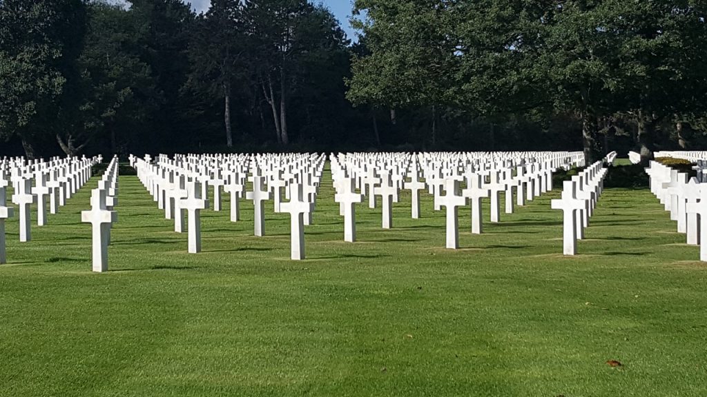
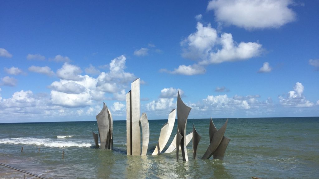
It is now Sunday, September 1st, and we arise early for breakfast and disembark the ship for a 2-hour bus ride to the Normandy Beaches. Upon arriving at the American Memorial and Cemetery at Omaha Beach, we meet our guide for a 2-hour walk tour of the German bunkers and encampments, the American Memorials, and the American Cemetery. It is a moving day trying to imagine the shear will, determination and sacrifice of those young men & women who landed on those shores on D-Day just 75years ago. Shortly before lunch, we climb aboard our bicycles and pedal a mere 7.5 miles down the coast to a small castle, “Chateau d’Asinieres en Bessin”. Carl, the owner, gives us a brief history of the castle from the time it was built in 1672, and then rebuilt in 1783, through World War II to become the Bed & Breakfast that it is today, (it still has its moat!) It turns out that Carl is also a Chef, and he provides us a lunch of smoked duck spring rolls, salads, cheeses and apple compote. Today is also our guide, Clem’s, birthday, and so we have all ridden with balloons on our bikes, sing him “Happy Birthday” and share a bit of cake before setting off again for a 14.5-mile ride through the countryside to an ice cream shop located at a milk farm. After enjoying ice cream, we finish our daily ride with another 15 miles to the town of Bayeux – the old capital city of William The Conqueror. Here is located the world’s longest tapestry, the 1000-year old Bayeux Tapestry displayed in a custom museum. The Tapestry is 70-meters long and depicts the story of William The Conqueror. Across from the Museum stand a 1000-year old waterwheel that still works, and a huge, stark cathedral. After touring the town, we boarded our bus for the short trip back to our ship which has now moved back up-river and is docked in the town of Caudebec-en-Caux. After boarding, we catch a bit of a 1-hour history presentation by Nigel on the D-Day Invasion. Nigel is a Brit, World War II history expert, artist and published author who has lived in Normandy area for decades. When he finishes, the ship sets sail to continue up-river, and we ready ourselves for dinner. And an evening of classical music.
The American Cemetary at Omaha BeachMemorial to D-Day Troops that Stormed FranceThe Bed & Breakfast at Chateau d Asinieres en Bessin
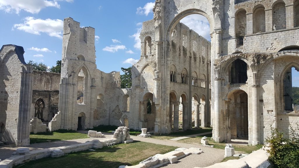
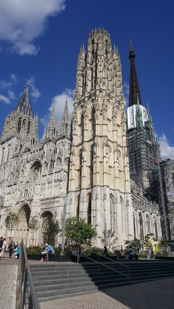
The boat travels during the night and arrives the city of Rouen at about 4:00am. We have breakfast and meet on the Quay at 8:30am to prepare the day’s bicycle ride. Today’s ride begins with a difficult 1.5-mile, 400-foot steep, uphill climb before reaching a plateau and coasting another 4.5-miles along the shores of the Seine River to a local ferry crossing. We arrive at the ferry crossing, but the ferry is having technical difficulties and is testing maneuvers in the river. After a 45-minute wait, the ferry has deemed the difficulties resolved and we board for the short crossing to the other bank. Once there, we relax at a local café for a hot coffee before pedaling another 25-miles along the Seine to another ferry crossing back across the river, and then to the town of Jumieges. Here we enjoy a delightful lunch of salads, fish and squid at a small restaurant and take the opportunity to explore the 7th-Century Auberge des Ruins – the ruins of the Abby of Jumieges! The ruins are remarkable in their stonework, their soaring arches, and their durability. Then, it is time to bicycle back to the ship. Along the way, we stop for a quick snack at the Abby of St. George de Boscherville before completing our 23.4-mile return, including one very substantial hill and arriving back at the quay. Once back, we meet our local town guide, Natalie (again!) and start a tour of the historic sights of the city of Rouen. Much of the old town along the river burned during the Nazi occupation, (45% gone), but much of the other old parts of town survived, including the Gothic Cathedral of Notre Dame, Medieval Clock and Parliament building. The cathedral’s gothic façade was completed in the 16th century and was the subject of a series of paintings by Claude Monet which are exhibited in the Musée d’Orsay in Paris. It did take 2-hits by Allied Bombs, but survived rather unscathed from the war, and was quickly repaired. Down the street, the Gros Horloge is an astronomical clock dating back to the 14th century, of which only a few others have survived, including one in Prague and one in Venice. The city is also known as the site where Joan of Arc was brought in 1431 to be threatened with torture and subsequently burned at the stake. Today, in the center of the Place du Vieux Marché is the modern church of St Joan of Arc. It is a large, modern structure that represents an upturned Viking boat. Nearby stands a cross marking the site where she died. At the end of the tour, we learn that tonight there will be a light show at 9:30pm displayed on the façade of the cathedral. At the tour’s end, we return to the ship for the Captain’ Gala Cocktail Reception and Dinner. After dinner, we stroll back to the Cathedral for the light show and take seats on the surrounding steps to enjoy the ~30-minute show with music and creative animations. Then, back to the ship for night-caps and bed, with the ship disembarking at ~4:00am.
The Ruins of the Abbey of JumiegesTheGothic Cathedral of RouenMemorial to Joan of Arc in Rouen
The next morning (Tuesday) the ship is still underway, and so we take a late breakfast and then relax in the ship’s on-deck hot tub. After lounging the morning away, we meet on the sun deck for today’s ride briefing, have a quick lunch, and disembark to our bicycles when the ship docks in the town of Vernon. Vernon was founded in the 9th century but is principally known today as the gateway to Giverny and Monet’s house. We climb on our bicycles and ride the short ~3 miles to Giverny, dismount and enter the gardens of Monet. Monet moved here in 1883 with his wife and 8 children and settled into the green-shuttered pink house known as “The Cider Press”. He was an avid gardener and lived and painted there until his death in 1926. The gardens consist of two parts – the Clos Normand Flower Garden near the house, and the Oriental Water Gardens, that are so famous, located across the street. These gardens were the subject of over 500 paintings by Monet. In 1960, Monet’s son bequeathed the property to France, and it subsequently deteriorated until 1977 when a significant fundraising and restoration effort began. The restored Gardens and home were opened in 1980, and today are carefully tended. We wandered the green-bridge paths around the water-lily ponds, strolled along the small diverted stream, and marveled at the abundance and variety of flowers in the house’s gardens. After visiting the house where the walls are covered by Monet’s works and other of his art interests, we shop in the small gift shop before making our way back to our bicycles and heading off on another 9-mile ride to The Chateau de La Roche Guyon – a medieval castle build into the soaring white chalk cliffs on the banks of the Seine. The extensive rooms at the back of the Chateau that tunnel back into the rock were used by the Germans during World War II for ammunition storage. Today, the castle’s restoration is still underway, but the portcullis, terraces, chapels and a series of lounges, subterranean passages, dungeons and casemates are open to view and wander through. Even the comic author’s, (Edgar Jacobs), “chronoscaphe” is still preserved there in an eerie and strange setting. Then it was time to ride the 18-miles back to the ship for the short sail to La Roche-Guyon and to prepare for drinks, dinner and the evening’s entertainment – a musical tribute to Edith Piaf by singer Caroline Nin. The moving story of Edith’s life told in narrative and song was punctuated by Rocky being taken to the stage to dance and support Caroline’s show. After the show, we joined the guides and Caroline for drinks, stories and laughs before calling it a night, as the ship set sail for Conflans St. Honorine.
The Water Lily Gardens of Monet in GivernyChateau do La Roche Guyon built into the Limestone Cliffs
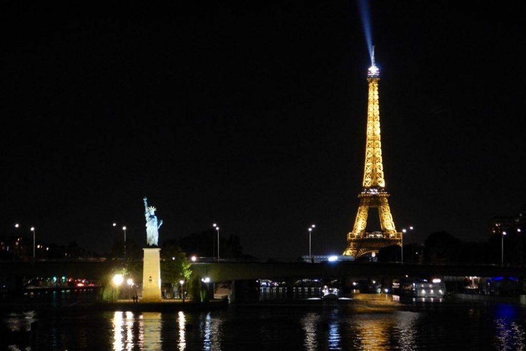
The ship reaches Conflans at about 7:00am, and after breakfast, our group meets onshore to review today’s route that includes gravel and some rough off-road portions. Once prepared, we begin our 10-mile bicycling trip along the shores of the Oise River to the town of Auvers-sur-Oise and the last home of Vincent’s Van Gogh and where he spent the last 70-days of his life. The Auberge Ravoux is a French historic landmark located in the heart of the village and where van Gogh was a lodger. During his short stay at Auvers, Van Gogh created more than 80 paintings and 64 sketches before supposedly shooting himself (?) in the chest on 27 July 1890 and dying two days later. We tour the old house, take time to visit the local cathedral, and have a relaxing coffee at the Absinth House before re-boarding our bicycles and setting off on a scenic 9-mile loop past the Van Gogh brothers’ graves and across the rolling hillside and meadows before returning to Auvers for a final bicycling picnic. From here, it’s a return 10-mile ride back to the ship and saying a final goodbye to our bicycles and our guides Carlos and Clem. We clean-up for a spectacular lunch in the dining room highlighted by mussels and oysters on the half shell, and a subsequent afternoon ice cream social up on deck as the ship leaves Conflans and heads for Paris. In the afternoon, we repack most of our belongings and prepare for our last night aboard. At dinner time, our group takes over the Chef’s Table Dining Room for a special group 7-course French dinner and a chance to socialize with each other and with our Backroads guides, Otis and James. The ship arrives back in Paris at ~9:00pm, and we promptly all take our drinks up on deck as we sail along the Seine and watch the sparkling light show on the majestic Eiffel Tower. It’s a beautiful and perfect end to a wonderful trip, as we head back our room for a good night’s sleep.
Auberge Ravoux – The Last Residence of Vincent Van GoghThe Sparkling View of Paris at Night
The next morning, we set our luggage out, have a good breakfast, say our final goodbyes, and board our taxi for the Charles de Gaulle Airport. It has been an exciting and informative adventure that we are very glad we did.
We very much like to take trips to go places we haven’t been before, and to see things that we haven’t yet seen. However, we also like to be active, which means we look for trips with bicycling, hiking or multi-sports as the basis of them. We also hate to unpack and repack every day as we adventure our way along, and so, for the first time, we engaged on a riverboat-bicycling trip with the Backroads Bicycling Company, in conjunction with Ama Waterways’ river-boat, for an eight-day trip down the Seine from Paris to the coast at Normandy, and back to Paris. This would allow us to explore a greater portion of the countryside and obviate the need to pack or unpack along the journey. It would also allow us to take in the wonders of Paris, (with a personal 4-days spent there – pre-trip), travel the historic lands of Richard-the-Lion-hearted, learn the history of the Normandy Region, honor the fallen on the French beaches of the English Channel at Omaha on the 75th anniversary-year of D-Day, and wander through the water-lily gardens of Monet and visit the home of Van Gogh. This seemed to meet all of the criteria of my wife and I and our traveling companions, her sister and brother-in-law.
Map of Paris
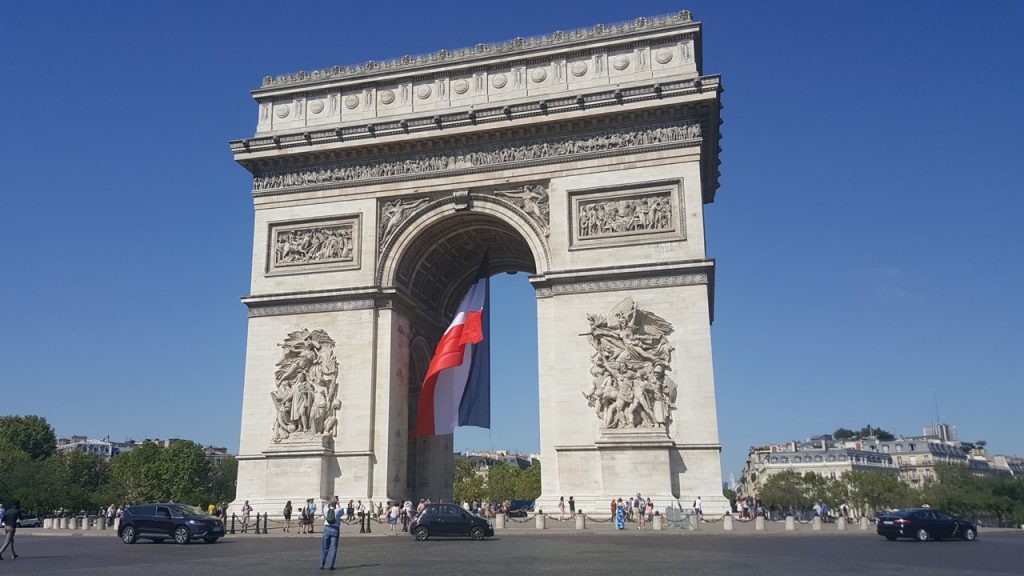
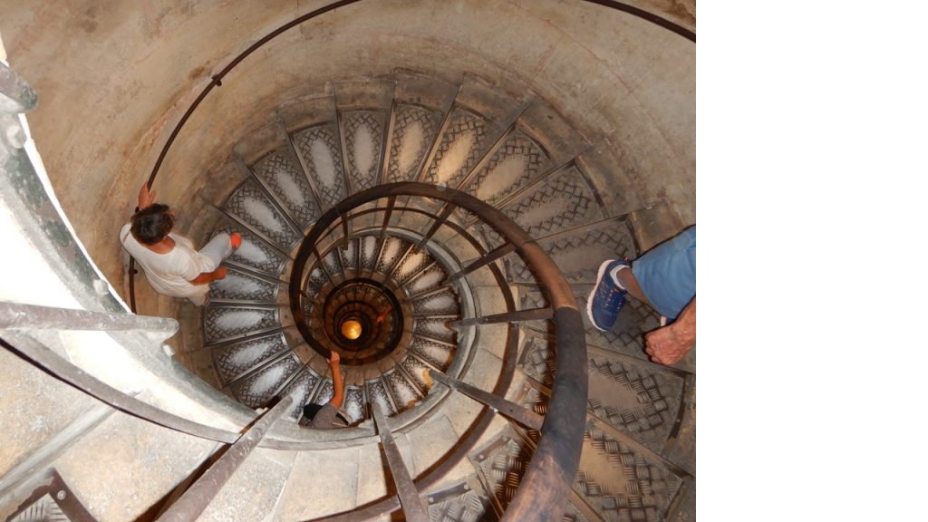
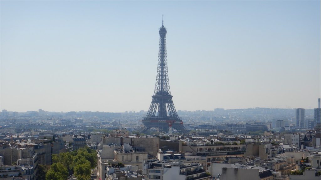
Our adventure began with my wife’s sister and brother-in-law meeting us in Washington, D.C. for our overnight flight out of Dulles International Airport. In order to get us used to “European Travel”, we took the complicated, (but inexpensive), route involving buses and metro-trains from Huntington Station in North Virginia, all the way to the airport – about a 2-hour trip! This, of course, was followed by the typical 2-hour check-in/security/wait/board routine that all international flights require, and then by an 8-hour flight to Paris De Gaulle Airport, arriving Sunday morning, August 25th, 2019. From here, we took a bus to Paris city-center and finally exited the bus across the street from the Arc de Triomphe de l’Étoile (“Triumphal Arch of the Star”) and walked the 2-blocks to our hotel – The Balmoral. Although it was only ~10:00am in the morning, they checked us in, and after a quick clean-up, the four of us set forth to start our exploration of Paris. It seemed obvious that the first place we should explore was the Arc de Triomphe de l’Étoile located at the western end of the Champs-Élysées Boulevard, at the center of Place Charles de Gaulle. This circle used to be named Place de l’Étoile — the étoile or “star” of the juncture formed by its twelve radiating avenues that emanate away from it. The Arc de Triomphe honors those who fought and died for France in the French Revolutionary and Napoleonic Wars, with the names of all French victories and generals inscribed on its inner and outer surfaces. Beneath its vault lies the Tomb of the Unknown Soldier from World War I added in 1920. We found the underground tunnel that took us to its entrance, bought tickets, and climbed the 202 steps to the mezzanine level to enjoy the view, and then the additional 82 steps to the terrace level/roof observation deck. The Arc de Triomphe was designed in 1806 and was inspired by the Arch of Titus in Rome, Italy. It was sanctioned by Napoleon and took ~30 years to construct, being competed in 1836. Napoleon’s ashes were buried there in 1840. It is 164-feet tall, 148-feet wide and 72-feet deep. Three weeks after the Paris victory parade in 1919 marking the end of World War I, Charles Godefroy flew his Nieuport biplane under the arch! After the tour of the Arc, we had a light lunch and began a leisurely stroll southeast down the Champs-Élysées Boulevard past designer stores, until we reached the Grand Palais. From here, we crossed the Seine River on the spectacular Alexander III Bridge and walked back west along the “Riverbank of Invalides” to the bridge Pont de l’Alma with an excellent view of the Eiffel Tower. We then walked up George V Boulevard past Rolls-Royces, Bentleys, Porches and Lamborghinis to return to the Champs-Élysées and our hotel. That evening, we enjoyed a classic Fish & Chips Dinner at a British Pub and discovered a local Supermarket where we bought wine and pate for a late-night snack.
The Arc de Triomphe de l’EtoileThe 202-Step Spiral Staircase up The Arc de TriompheView of The Eiffel Tower from The Arc de Triomphe
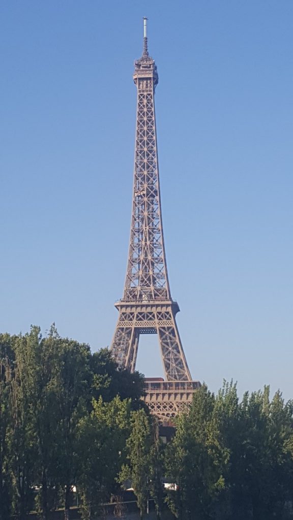
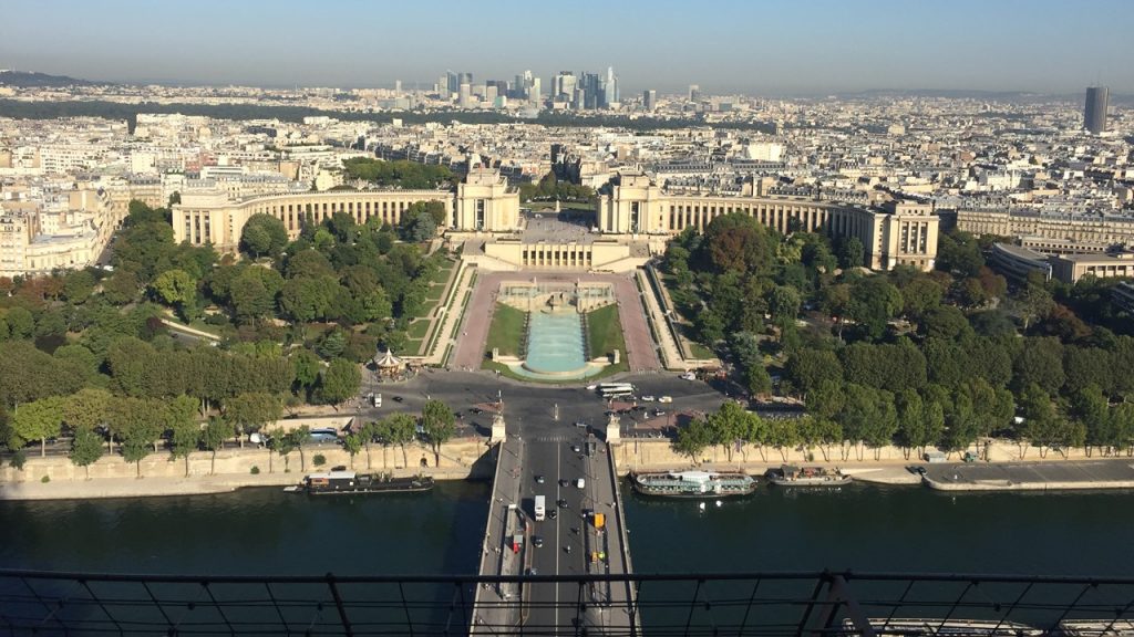
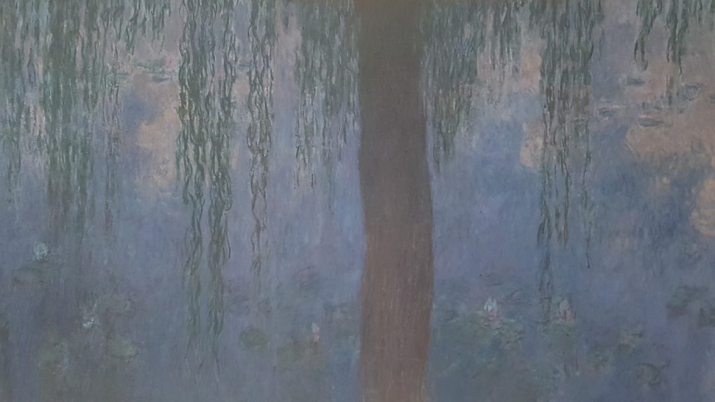
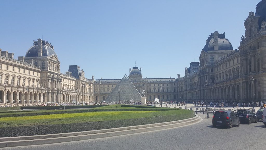
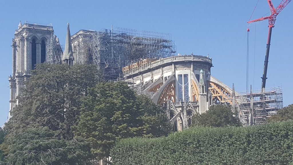
Monday morning, we had a quick breakfast before crossing the Seine and walking to the Eiffel Tower. We had not been able to pre-buy our tickets 24-hours in-advance, and so we took the next best option to avoid any long elevator lines – walk-up! It was 354 steps up to the First Level where there are a food and drink options, and a small historical display. Then it was another 320 steps to the Second Level which offered additional options, an excellent 360-degree views of the city, and access to the elevator to the top. The Eiffel Tower is located on the Champ de Mars and it is named after its engineer, Gustave Eiffel, whose company designed and built the tower. It was constructed in only 26-months, completed in time for the 1889 World’s Fair and is the most-visited paid monument in the world with nearly 7-million visitors ascended it in 2015. The tower is 1,063-feet tall or the same height as an 81-story building, and the tallest structure in Paris. Its base is square, measuring 410-feet on each side. During its construction, the Eiffel Tower surpassed the Washington Monument to become the tallest man-made structure in the world, a title it held for 41 years until the Chrysler Building in New York City was finished in 1930. The top level’s upper platform is 906-feet above the ground – the highest observation deck accessible to the public in the European Union. The Tower also served as a centerpiece for two other World Fairs held in Paris over the next 45 years. After enjoying the view from the top, we took the elevator back to the Second Level, walked the 320 stairs down to the First Level, and then took the elevator down to the Ground Floor. We then crossed the Seine and walked towards the Louvre Museum. Along the way, we decided to stop and visit the nearby Museum de l’Orangerie which is an art gallery of impressionist and post-impressionist paintings located in the west corner of the Tuileries Gardens next to the Place de la Concorde. The museum is the permanent home of eight large Water Lilies murals by Claude Monet, and contains additional works by Cézanne, Matisse, Picasso, Renoir, Rousseau, and others. After touring the Gallery, we strolled through the Tuileries Gardens and associated sculpture parks until reaching The Louvre. The Louvre is the world’s largest and most visited art museum and is housed in the Louvre Palace, originally built as the Louvre castle in the late 12th to 13th century. In 1546 it was converted it into the main residence of the French Kings. In 1682, Louis XIV chose the Palace of Versailles for his household, leaving the Louvre as a place to display the royal collection, During the French Revolution, the National Assembly decided that the Louvre should be used as a museum to display the nation’s masterpieces. The museum then opened in 1793, although it has grown quite a bit since then. We then crossed the Seine River again to see the status of the Notre Dame Cathedral after the horrendous fire that severely damaged it earlier this year. We walked around the entire Cathedral observing the structural supports and massive construction and repair that is underway. After this visit, we ventured underground and caught the Paris Metro-train to arrive back near our hotel. For variety, that night we ate Chinese and finished the evening with a few glasses of French red wine.
The Eiffel Tower from the Seine River.View down the Seine River from The Eiffel TowerThe view East from the Eiffel TowerMonet Painting in Museum de l’OrangerieThe Louvre from The Tuilerie GardensRepair Underway at The Cathedral of Notre Dame
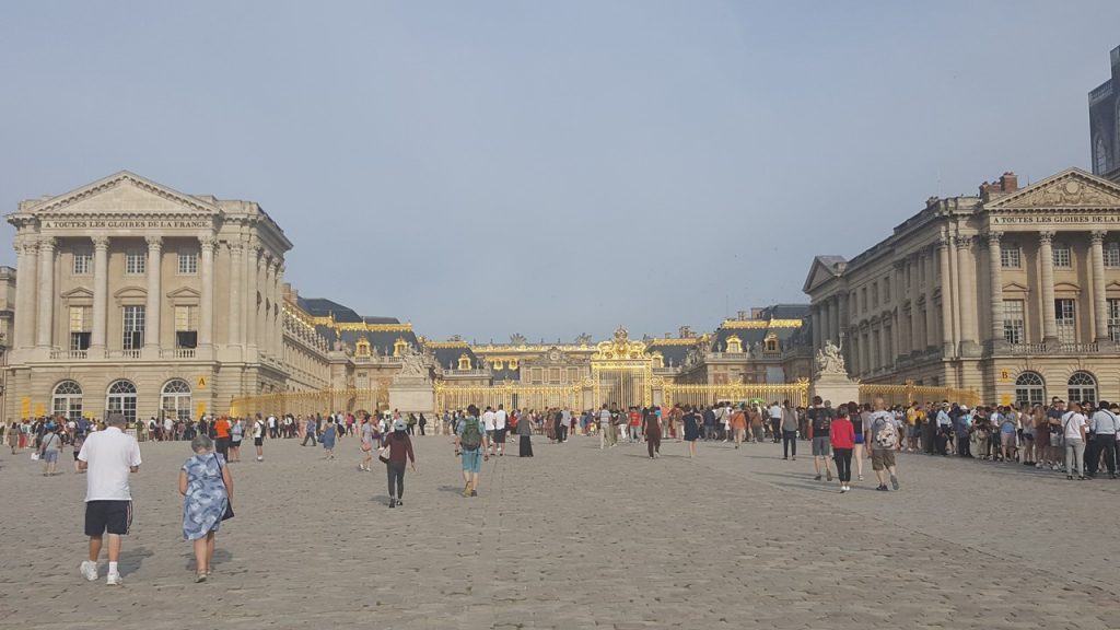
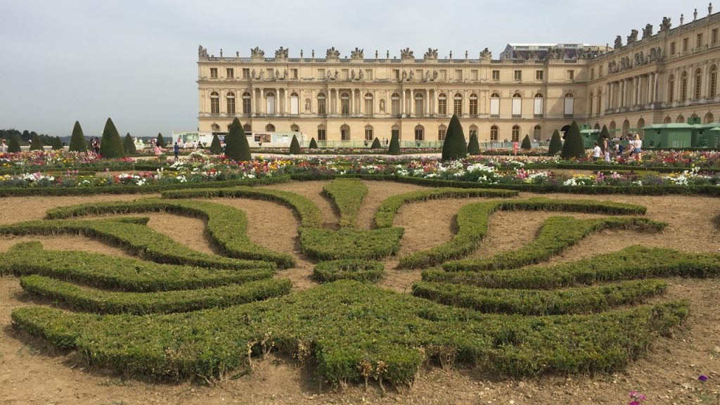
Tuesday, we had reserved for a visit 12 miles outside of Paris to The Palaces of Versailles. The Palace of Versailles was the royal residence of France from 1682, under Louis XIV, until the start of the French Revolution in 1789, under Louis XVI. To get there, we needed to take the Metro-train to La Defense/Port Maillot and transfer to an RER Train that would take us to Versailles. We had already purchased “skip-the-line” tickets, and so entered immediately a bit before our scheduled time of 10:00am. The palace is now an historic monument and UNESCO World Heritage site and is also a very popular place to visit. We started our self-guided tour through the main residences with English audio-phones and spent nearly 2-hours marveling at the amazing Hall of Mirrors, the Royal Opera, and the suites of royal apartments, including those of Louis XV’s two unmarried daughters, Marie Adelaide and Victoire. After the French Revolution, the Palace was stripped of all its furnishings, but today, many pieces have been returned and nearly all the palace rooms have been restored. Then we proceeded to the immense gardens and grounds of Versailles with fountains, canals, and geometric flower beds and groves, laid out by André le Nôtre, and where we were treated to a special “Musical Gardens Day” with dancing fountains and classical music filling the groves. After a lovely lunch under the trees at a restaurant in the gardens, we continued our walking tour to visit the other royal residences located here, including the Grand Trianon and Petit Trianon, residences built in the 1760’s for Madame de Pompadour, (Louis XV’s mistress), and later occupied by Marie Antoinette. By 5:00pm, we were exhausted, and so we headed back to Paris via the train, took showers, went to the “Beer Station” for drinks, and had a light salad dinner before calling it a night.
The Entrance to The Palaces & Gardens at VersaillesA Few of the Extensive Gardens at Versailles
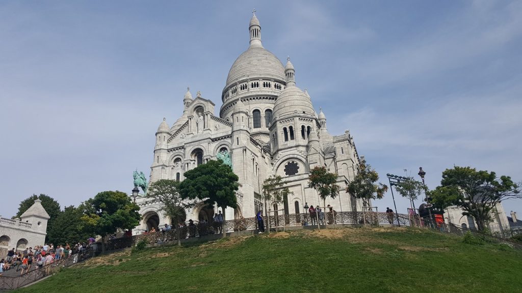
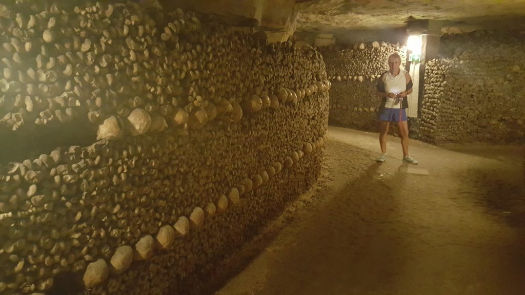
Wednesday was to be our last day on our own in Paris, and we had arranged to have lunch with a couple of young friends who now live just outside the city. The restaurant was in the northern part of the city, and so we decided to take the metro there and visit the nearby Basilica of the Sacred Heart, locally known as Sacré-Coeur Basilica. It is a popular landmark in Paris, and it sits atop the summit of the butte Montmartre, the highest point in the city. Construction on the Basilica began in 1875 and was completed in 1914. Today, it also serves as a base-location for numerous artists and portrait artists. After climbing the hill to the base of the Basilica, we visited the church, and then undertook the climb up 300 narrow spiral staircase stairs to the viewpoint on the church’s spire. From here, all of Paris and the surrounding area was visible, as will as the nearby bell tower. After climbing back down and exiting, we wandered among the artists and did a little shopping while making our way back to the base of the Basilica. From here, we rode the Funicular down the hillside, and started walking toward our lunch restaurant. The restaurant was “Montcalm” and was located further north of the Basilica, requiring a tortuous up-and-down hike to arrive just on time at 1:00pm. Here we met our friends, and the restaurant owners who were childhood friends of theirs. After a lovely French lunch of beef with potato puree and spinach, with a rice pudding desert, we walked back to the Metro and traveled south to Place Denfert-Rochereau. This square is the location of the Paris Catacombs museum and is where the entrance to the underworld is located. It is also frequently the place where demonstrations and protest marches in Paris either start or end. Again, we had bought “skip-the-line” tickets and entered the catacombs at 4:30pm. The Catacomb Tour told the entire history of these catacombs from when the tunnels were created in Roman-times as a quarry for limestone blocks to build the buildings of Rome, through their lost recognition and terrifying fatal collapses in the 1700’s, to the underground ossuaries of approximately 6-million people today. The ossuary extends south from the city’s “Gate of Hell and was created to eliminate the city’s overflowing cemeteries. Serious work began after a 1774 series of gruesome cemetery-wall collapses and a growing concern about disease and unsanitary exposures. From 1786, daily covered wagons transferred remains from most of Paris’ cemeteries to a mine shaft opened near the Rue de la Tombe-Issoire, where the remains were dumped in and a mountain of remains grew. Soon, a group undertook “organizing” the remains – stacking the bones and skulls into “vaults” of geometric and artistic patterns. This The ossuary then remained largely forgotten until it became a novelty-place for concerts and other private events in the early 19th century. It has been open to public visitation since 1874, and although the ossuary makes up only a small portion of the underground tunnels of Paris, they are certainly the most visited. After a ~1.5-mile journey through the tunnels, we exited and began our Metro ride back to our hotel for dinner, and to pack to begin the next (bicycling) portion of our adventure.
The Basilica of The Sacred Heart on the Summit of MontmartreThe Ossuarie in the Catacombs of Paris
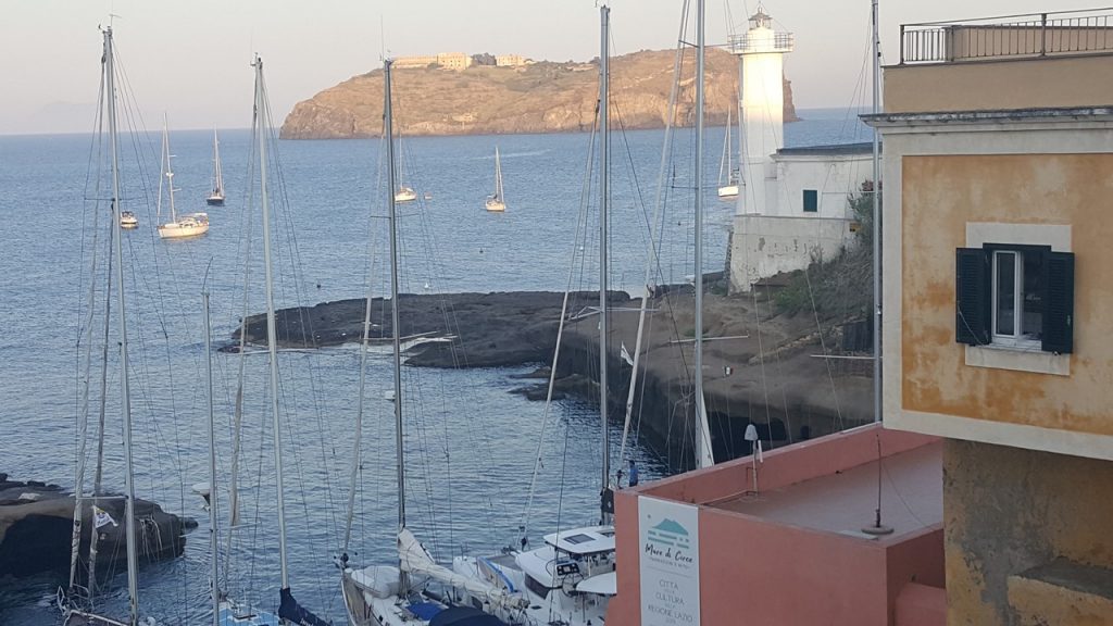
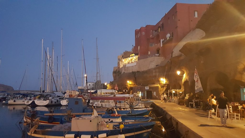
Sunday morning, August 4th began our second week of exploring the Gulf of Napoli and Amalfi Coast, and we set out on our 46’ Dufour Grand Liberty Sailboat from Marina Sud Cantieri in Pozzuoli and headed northwest into the Tyrrhenian Sea to the Isola di Ventotene, the largest of the Pontine Islands. The island was known in Roman times as a popular place to exile ex-wives and other important “undesirables”, and still hosts an abandoned penal settlement on nearby Isola di San Stefano. Here, we tried to get a spot at Marina di Ventotene, but after initially claiming to be full, we were belatedly offered space for an exorbitant 250 euros per night. We politely refused, and instead, dropped anchor in the channel and moored our stern to the free city wharf on the east side of the harbor. Then, Nikki & Jordan immediately went shopping and exploring the city and overlooking bluffs, and secured dinner reservations for all of us at an excellent restaurant that was overlooking the harbor from high up in the city.
Ventotene Harbour with San Stefano in ViewThe Inner Harbour at Ventotene
The next morning, on Monday, August 5th, we made the short trip motoring back southeast to the Island of Ischia, but this time, we went to the western port city of Forio. Forio is small town on the island but with a beauty and beaches that are now famous. Here, history enthusiasts will find plenty of interesting sights such as the remains of the Aragonese Castle, the Villa Colombia and more. Once into the marina, Nikki & Jordan went ashore looking for places to visit and for dinner, and the rest of the girls went to the beach to swim. That night, we ate ashore at a restaurant overlooking the shore watching a beautiful sunset.
The Beach at Forio on IschiaSunset at Forio
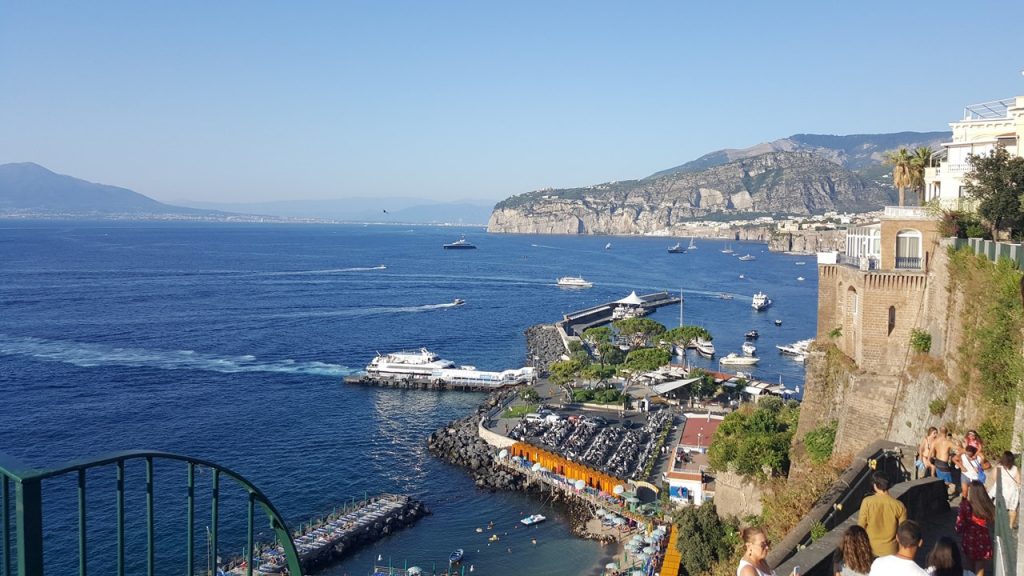
On Tuesday, August 6th we continued our travels southeast across the Gulf of Napoli to the Port of Cassano, located down the face of sheer cliffs below the town of Piano di Sorrento and about 1 mile east of Sorrento. After getting showered and collecting some ice, we all took the elevator located inside the cliffs to the top of the bluff, where we walked about ½ mile to the town’s train station, bought tickets, and took the local metro-train two stops west to the center of Sorrento. Here, everyone dispersed to change money, shop and enjoy the lovely views until we met up again at the top of Sorrento’s scenic viewpoint at a little café. After drinks and nibbles, most of us headed back to the Sorrento train station, while Nikki, Peter and Rick walked the mile-plus back to Cassano. We all arrived back at the marina at the same time, where we took seats at a local restaurant for dinner and drinks.
The Harbour at CassanoCoastal view from Sorrento
After leaving Cassano on Wednesday morning, we rounded the Sorrento Peninsula and headed east-northeast down the coast to revisit the town of Amalfi. Again, our favorite marina chief met us and expertly navigated us into position at the dock close to that place where we had been before. This time, we explored the city more extensively, including hiking the local tunnels and switchback walkways weaving through local enclaves around the sides of the city’s steep cliffs. After drinks and people watching, we gathered for dinner at a favorite Amalfi restaurant, and settled in for a windless, warm night nestled into the corner of the marina.
The East coast from Amalfi
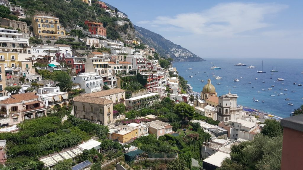
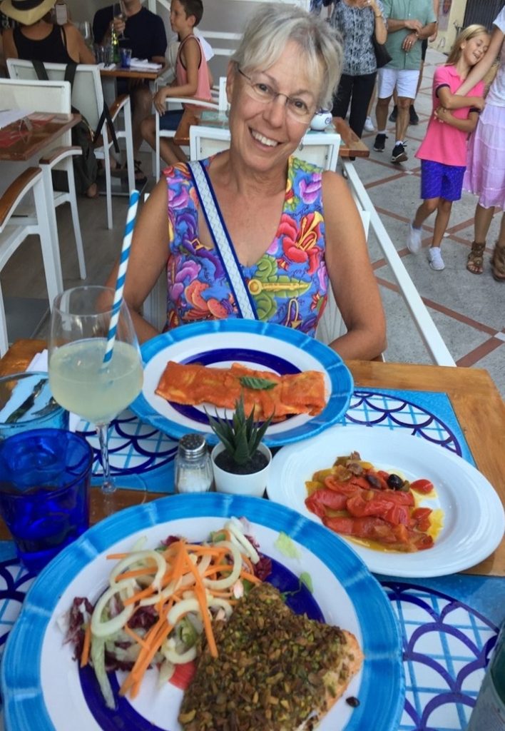
The next morning, Thursday, August 8th, we again made a stop at the fuel dock to top off our diesel tanks, and then made the short trip back up the coast to Positano where we met our favorite “ormeggi” water-taxi-man, who connected us to a mooring ball and taxied us to shore. We set a time of 7:30pm for everyone to meet to return to the boat, and after a day of shopping, eating, drinking, and taking chairs and umbrellas at the beach, everyone except Nikki, Peter and Jordan met and ferried their way back to the boat. While ashore, Rocky and Julie celebrated (a day late) their 46th Wedding Anniversary with a spectacular meal. The three ashore made an attempt to gain entrance to a favorite haunt of celebrities, and after modest success, returned to the boat late at ~10:30pm.
The Amalfi coast from PositanoAnniversary Dinner
Friday morning, August 9th, we began our long trek back to base, initially motoring, but then sailing for 4 hours across the Gulf of Napoli to the Gulf of Pozzuoli. After tacking back and forth in the Gulf of Pozzuoli enjoying the quiet sailing time and eating a late lunch, we finally headed in at ~3:30pm and took up our spot at the Marina Sud Cantieri Dream Yacht Base. We “checked out” the boat, enjoyed the excellent facilities there, and then headed back to Un Pizzico Di for a final group dinner. That night, Nikki, Peter and Jordan packed for an early morning exit the next day while the others reminisced and shared stories.
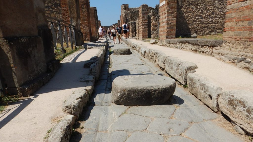
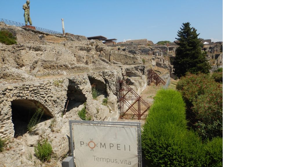
On Saturday morning, August 10th, Nikki, Peter and Jordan left at 6:30am and headed to the train station for the next leg of their adventure in France and Hungary. The rest of us left in a taxi at 9:30am and headed to the center of Naples where everyone had arranged accommodations for 1 or 2 additional nights. We (Julie and Rocky) upgraded our room at the Star Hotel and got immediate early entrance. After a quick change, we headed over to the train station and caught the local metro-train to Pompeii, where we explored the ruins for ~3 hours. Upon exiting the park, we grabbed a quick lunch before catching the express train to return to Naples and a relaxing late afternoon at the hotel. That evening, we explored the center of town by foot, before grabbing a light dinner and a bottle of wine to enjoy back in our room.
The streets of PompeiiThe ruins of PompeiiCity Centre Naples
Then, the next morning, it was a taxi to the airport and a flight home to end a busy and beautiful visit to Italy’s Amalfi Coast.
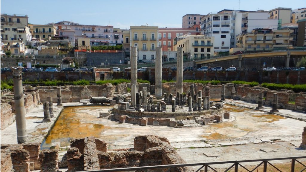
It was Friday, July 26th and time to leave the heat of the east coast of Florida, and fly to Newark and then to Naples, Italy, which was in the midst of its own heat wave. We arrived in Naples on Saturday morning July 27th, and took an adventurous taxi ride, (numerous complaints and stops to ask for directions), to the northwestern coastal suburb of Pozzuoli, to Marina Sud Cantieri where we met Mario with Dream Yacht Charter Base. It was still early, so we dropped our gear in the Dream Office, and proceeded to get breakfast at the café across the street. We then checked out the local grocery store and walked into the town of Pozzuoli to visit some local Roman Ruins. Soon, Peter, Nikki, Mary Jane, and Rick arrived at the Dream Office, and when Elaine and Terry arrived, we gathered for lunch at Un Pizzico Di, whose proprietor we convinced to open early for us. Then the girls went shopping at the local supermercado for groceries and supplies, and we completed our boat check out for our 46’ Dufour Grand Liberty sailboat named “Boqueirao”. Groceries were delivered at ~6pm, after which we all went out to eat near the waterfront in Pozzuoli where the Antipasto (3-course) and wine completely filled us up. Then, we headed back to the boat for chat, drinks and sleep.
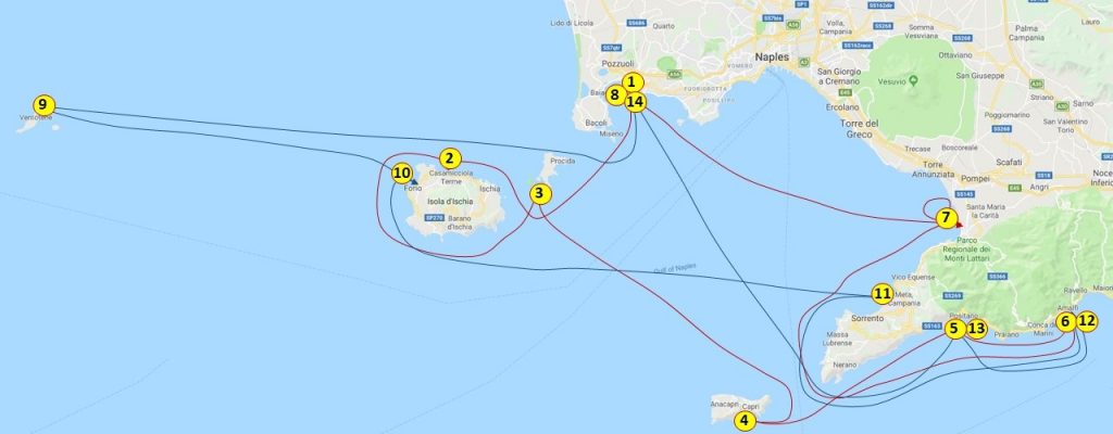
Map of our boat travels in ItalyRoman ruins in PozzuoliCity of Pozzuoli
Upon awaking on Sunday morning, July 28th, Mario informed us that the weather would quickly deteriorate, and we must leave by 10am or stay in the marina another day. We immediately left in rain and 20 knot winds from the west and sailed our way to the Isole d’Ischia, where we went to the northern harbor of Casamicciola for the night. Although the sails were reefed the whole way, the rough seas and strong winds had left many on our boat a bit seasick and the quiet harbor was a welcome relief. Rocky’s first Mediterranean Mooring had a bit of an adventure as we snagged a slime-line on the aft of the keel-bulb while backing in, but it was quickly solved as Rocky free-dived to the keel and dropped the line to the seafloor. The island of Ischia is an island of active volcanism, having experienced its most recent eruption in the 1300’s, and is now the site of many natural hot springs and spas. Some of the women took a taxi to experience one of the spas, and for dinner we all went ashore to a local pizzeria where we enjoyed mussels, fish and pasta.
Beach at Casamicciola on Ischia
The next morning, Monday July 29th, after a brief grocery run, we left Casamicciola, circumnavigated the island of Ischia, and took advantage of the good wind to head east to the small neighboring island of Procida and the little harbor of Chiaiolella where we moored at the marina dock. From here, some of us explored the large local beach, and walked the bridge that connected Isole di Procida to the nature preserve island of Vivare. After exploring the western end of the island, one group took a taxi to northwestern port of Marina Grande while the other group made the 45 minute walk through the city’s streets all the way across the island to meet up and have dinner at a quaint restaurant on a piazza with locals who were singing and playing music all evening long. After a bus ride back to the marina, we enjoyed nightcaps before calling it a day.
Walking through the Town of ProcidaMarina Grande Harbour, Procida
On Tuesday morning, July 30th, the winds left us, and we began a daily pattern of 3-5 knot winds in the morning, slowly rising to 7-10 knots in the late afternoon with the skies clear and the weather hot. Thus, we motor-sailed southeast towards Isole di Capri, famous for its people watching and shopping. Unfortunately, we could not get a reservation into any of Capri’s marinas, (only to find out later that this was because Heidi Klum was there preparing for her wedding in the Capri Marina on Saturday, August 3rd), and so we traveled through the Bocca Piccola between the island and the Sorrento Peninsula, to the southern side of Capri where we set anchor outside of Marina Piccola near the oft photographed Pillars of Isola Faraglioni. From here, we took our folks ashore by dingy to explore the town. The town of Capri is actually up on a ridge between the Gulf of Napoli and the Gulf of Sorrento. From the southern side, this required a bus trip up from the water’s edge, where from the north, there is a funicular that moves people up the steep slope. It was during this shuttling that we discovered that our dingy was not only very small and difficult to manage, but also had a “soft floor” which also made it a bit unstable, causing Peter to take a motor into the ribs which bothered him for a number of days. To make matters worse, the dingy ran out of gas on one of the return trips making for a source of numerous good stories and a long string of expletive adjectives that characterized our dingy. Needless to say, after this day, we never put the dingy in the water again! That night we ate spaghetti aboard the “Boqueirao” and enjoyed an evening at anchor.
Isola Faraglioni near CapriThe southern shores of Capri
On Wednesday, July 31st, we pulled up anchor and headed to the coastal town of Positano, about 15 miles to the east-northeast from Capri. That morning, the seas were again calm, and we motored across the Bocca Piccola where we surprisingly came up on a Pilot Whale crossing our path. We followed him for a bit before he dove deep and left us, and we celebrated our luck in seeing him. Upon reaching Positano, there is no marina, and so we picked up a mooring ball with the help from the local ormeggi – “Grassi Junior”, which came with water taxi service to and from shore. Positano is a town built into both sides of a ravine, and we chose to visit a former stop of Peter and Nikki’s located up on the south side for lunch. From this area, the view was spectacular, and the lunch was just as impressive. After lunch, we broke into groups visiting local bars, shopping and generally sightseeing much of the town. There was even a public beach where many locals and tourists were cooling themselves off from the hot afternoon sun. When the sun went down, we took the water taxi back to the boat for dinner and a night under the stars.
Pilot WhalePositano from the RestaurantThe ravine of Positano
Thursday morning, August 1st we dropped the mooring ball and made the short trip further down the coast to the town of Amalfi. The city of Amalfi is located 16 miles East away from Capo Punta Campanella, the headland at the SE extremity of the Bay of Naples, and eight miles W of Salerno on the Tyrrhenian coast of Italy. The city lies at the end of a ravine and is the center-point of a coast famous for its dramatic scenery and picturesque mountain villages. An earthquake and tsunami in 1343 destroyed much of the city and was an event from which the town never fully recovered especially the harbour. However, when the British classes discovered Amalfi, a modest tourist boom beginning in the 1920s, and has brought the town fame and prosperity. Unfortunately, it has also filled its harbour to bursting point and distance along its mole is at a premium during the summer months. Fortunately, we had a reservation at Marina Coppola which was acquired ~4 months in advance. The Marina Chief was a veteran of International sailboat racing and maneuvered our boat at breakneck speed through a tangled maze of lines, boats, docks and swimmers to snugly fit us into an inside dock space only 20ft from shore! Unfortunately, the Marina’s bathrooms and showers were wiped-out in a recent landslide, and were currently under construction, forcing us to check out the nearby dockside restaurant for drinks and facilities. Then, we all walked to the city center where we explored the spectacular local church and shops before returning to the marina for a quick beach swim and getting ready for dinner at an over-the-water restaurant.
The town of Amalfi
On Friday morning, August 2nd, we were chaperoned to the fuel dock where we topped-off our diesel tanks and began the trip back to the Gulf of Napoli. Terry and Elaine were planning to see Pompeii on Saturday, so we decided to head for a marina just west of Pompeii in an industrial area called Castelamarre di Stabia. Inaugurated in 2007, the marina of Castellammare di Stabia is considered one the greatest in the Mediterranean Sea with 900 berths for boats up to 80 meters long. This port is equipped shipyard 220-ton travel lift, shipyard shop, garage, among other services, which provided a convenient berth for an Italian Aircraft Carrier, and a suite of mega-yachts. After a long day of motor-sailing with only a short motor-less interval, we next experienced a long delay and communication issues with the marina. After idling around for an hour, we were finally shown where to go, and we found ourselves in a very welcoming but non-tourist part of the coast with many little street restaurants and shops along the waterfront for nearly a mile. After, showers at the marina, we decided to eat at a wharf-side restaurant called “Anna Maria’s” where were sat upstairs looking over the water and had an outstanding meal of fish, prawns and pasta fagioli. After dinner, we all wandered down the wharf through the crowds of locals to see some of the mega-yachts that were docked, including the Walton family’s world-class 350’ “Aguila” and the record-setting 404’ “Al Lusail”, owned by the Sultan of Qatar’s 4th son. After returning to the “Boqueirao”, we played music, had drinks, and chatted with a young local couple that Nikki had befriended on the wharf, before calling it a night.
The Marina at Castelammare de Stabia
Saturday morning, August 3rd, would bring the end of our first week’s sailing adventure. Terry and Elaine left the boat in Castelammare di Stabia, and we then set off motoring across the Gulf of Napoli to our home base in Marina Sud Cantieri in Pozzuoli. We arrived about 1:30pm, and Guy and Sue were waiting for us and ready to board the boat. After getting them aboard, we all headed back to Un Pizzico Di for lunch. The afternoon was spent restocking the boat with supplies, changing out all of the linens, and preparing to welcome Jordan, who would not arrive until late that night. For dinner, we headed down into the heart of Pozzuoli to an outdoor restaurant where we people watched and drank a great deal of wine. Upon returning to the boat, we awaited Jordan’s arrival via an arranged taxi from the airport. Jordan arrived around midnight, and after greetings and settling in, we finally went to bed about 1:30am, prepared to begin our second week.
We rose early on Sunday morning, February 24th to view our voyage to t Harbour.To get there, we will sail back across the Bransfield Strait and return to the Antarctica Peninsula. Along the way, we saw several humpback whales giving us an early morning show of breeching, fin slapping and tail slapping. The whales could be viewed in front of us, and on the side of us, and behind us, giving us an incredible show!Once we were in Orne Harbour (which is on the Arctowski Peninsula) the Expedition Crew went ashore to mark a trail.Here, the landing site is very small, and we will then hike directly ~300’ up the steep, snow-covered hill in a zigzag manner. The hill/mountain is covered in snow and ice and we can see the “paths” where other groups have made the hike.There are some sea lions sunning themselves on the rocks and on the top of the mountain one can see silhouettes of chinstrap penguins looking down at us.Several birds live in the area, but so far this morning it is very quiet. As we hike up the snow, some of the Expedition Crew cut crude steps into the snow to make it easier to climb. Once we arrive at the top, the view is exquisite. We could see Humpback Whales in the next cove and there was a Chinstrap Penguin colony as high as us in the surrounding rocks!It is amazing that these ungainly little penguins can make their way up these steep, rugged slopes to colonies so far from their home in the water.From our viewpoint, we could see the “penguin highway” paths that they travel, which came from the next cove. We could also see that it is truly the tourist season in Antarctica as, in the distance, we could see the National Geographic Explorer ship, and an Expedition Ship we saw in Ushuaia, the Marco Polo.The season is at the summer’s end and many of the summer bases are already fully closed.As we’ve gone south, the weather has gotten steadily colder and we are seeing much more ice. The hike down from the ice-covered ridge was a little more treacherous as the top layer of snow was melting and the downhill view was steep and scary.
Map of Track & Stops Antarctica Part 2
Humpback Whale Breaching
View of Orne Harbour
Chinstrap Penguins at Orne Harbour
View Down the Hill in Orne Harbour
The Climb at Orne Harbour
Rocky & Julie at the Mountain Top
Once back on board and during our buffet lunch, we start sailing to Errera Channel.
Errera Channel is home to a great many leopard seals and the crab-eater seals.While the second group of kayakers took off for a tour, the rest of us to rides in the zodiacs (polar crikel boats) around the channel to see the wildlife. Because it was so sunny, there were seals on all the small icebergs. The leopard seals are spotted with a long nose and sharp teeth for catching and eating penguins and are ~500 pounds in weight.They are so mellow when they are sun-bathing and did not pay us much attention.The crab-eater seals only eat krill and have shorted muzzles and are a beautiful silver in color.
Leopard Seal in Errera Channel
Crab-Eater Seal in Errera Channel
During a buffet dinner, the Captain moved the ship further down the channel to Danco Island where there is a beach area and a flattish-area for putting up 15 tents for those who have chosen to camp tonight in Antarctica.The camping rules dictate no food can be taken ashore and there should be no impact to the environment.Therefore, the campers will camp in tents on snow, and they will go to shore around 8pm and return by 6am.Once ashore, they will set up their own 2-person tents with only mattress pads, sleeping bags and a bottle of water. That evening, there was a beautifully colorful sunset followed by an evening briefing.
Monday morning, with the campers back on board, we begin a beautiful slow cruise to Paradise Bay, which was named by the whalers because it was so beautiful.There are 2 bases in the bay.The first of these is a Chilean Base, “Gonzales”, a summer base only and the 12 staff stationed there left 2 weeks ago.There is a huge Chilean flag painted on one of the buildings. Their focus has been the study the local penguin colonies. Further along is the Argentinean Base, “Brown Base”, still staffed with its icebreaker ship stationed out front.They also study penguins in the area by motoring around with a smaller water boat. Next, we turned into the Ferguson Channel, where we are met with some huge icebergs.All along the way we see Humpback Whales just floating on the surface, barely moving. Lucy, our whale expert guesses that they are already gorged and are taking a brief rest before beginning their migration north out of Antarctic waters. From here we turn right into Gerlache Strait and head northwest to enter the famous and scenic Neumayer Channel. Neumayer Channel is often not passible due to extensive ice, however, recent word from other ships is that we may be able to travel along it.All along the way, the sky remains overcast with clouds blocking the view of the tops of the mountain peaks.However, at 10:30am the weather and the view allow us to assemble all the passengers on the bow of Deck 5 for a group picture. The Captain was in the windows of the bridge waving to everyone.This was an ideal place for the picture since Neumayer Channel is shaped like an ’S’ and is 15 miles long. Belgian explorer Adrian de Gerlache named Neumayer Channel after German explorer and scientist Georg von Neumayer, who sailed it during his Antarctic Expedition of 1897-1899. It is surrounded by high mountains, ice-covered cliffs and steep glaciers. As we head for Damoy Point, we pass Vinca Island which is named for a sailor who was washed overboard on Gerlache’ Expedition while he was cleaning out a ship’s scuppers.
Entrance to Neumayer Channel
Reflections in Neumayer Channel
We did an early lunch in preparation of our landing at Damoy Point as the two of us will be kayaking today.We arrived at at Damoy Point ~12:30pm, and in the interim, we changed into our long underwear and 2-pairs of socks, and then head to deck 2 to put on polar fleece jumpsuits and neoprene dry suits. We then added neoprene boots and neoprene mittens that connect directly around the kayak paddles.Finally, with hats, scarves, neck buffs, lifejackets and cameras, we board the zodiacs for a short ride to a rocky beach on Damoy Point in Dorian Bay where our kayaks are waiting. Damoy Point was originally discovered by the French Antarctica Expedition of 1903-1905 under Jean-Baptiste Charcot.While we kayak, the rest of the passengers will explore scientific huts and the hill’s viewpoints.There are Gentoo penguins here and blue-eyed cormorants.The one hut was built by the British in 1973 and was used for several years as a summer aircraft landing facility.The landing strip was on thick, blue-ice that has since melted away and was used for planes to bring supplies to Port Lockroy.Since this area stayed frozen so much of the year due to its southernly latitude, the runway had allowed researchers in Port Lockroy and Rothera Bases to get an early start on their research without having to depend on ships. It was last occupied in 1993 and has been designated as a Historic Site. Today, Rothera Base has its own runway. There is also a hut here built by the Argentinians and kept supplied by the nearby Uruguayan Base. Once we approach the beach in our zodiacs, we unloaded into cold waters of the bay to walk ashore since the area was very rocky. We adjusted our kayak pedals and paddles, climbed in, and then were gently pushed into the frigid waters. There are 14 of us in seven double kayaks and 2 guides in single kayaks. The water, while extremely cold, is very clear and it is very quiet out there. There are penguins in the waters around us and the current quickly moves us out of the bay toward the ship. Once everyone is accustomed to paddling, we explore the area around the bay, stopping for a group photo. After ~3 hours, it was time to return to the beach and return to the ship.
Kayak View of Argentinian Base at Damoy Point
Despite all the clothes our feet and hands were quite chilled, so, after arriving, we head straight to the hot tubs for a warmup and watch the remaining passengers hike back to the zodiacs to return to the ship.
Dinner was an “Arctic & Antarctic” buffet.The Captain then took us on a slow, leisurely cruise in the Lemaire Channel past “Eunice’ Tits” Peaks and Booth Island.The channel is 5 miles long and at its maximum, is only 1600 meters wide. It is very much a picturesque moment.However, tonight the clouds are low, and one cannot see the tops of the peaks.We sail slowly, dodging the icebergs of varying sizes. In a small bay, we spot a small polar ship but, since there is no base nearby, it is probably doing some sort of research. Eventually, we exit Lemaire Channel and enter into French Passage and are in front of Pleneau Island and Petermann Island that we will visit the next day.However, there are a large number of moving icebergs here, so the Captain backtracks up the Lemaire Channel to wait until morning, when we will again sail to Petermann Island for a landing. Then, later in the Panorama Lounge, four of the Expedition Staff did a talk show based on the research of Rob with birds, Sam with plankton, Beluga with whales/dolphins, moderated by Monica, who was also a bird researcher.
The next morning is Tuesday, February 26th, and our last day in Antarctica!The ship was moving early this morning back down Lemarie Channel to Petermann Island.In order to enjoy the view, we were up early, ready for breakfast, and prepared to be the first passengers ashore for an early landing on Petermann Island (latitude – 65 degrees 10 minutes south).Petermann Island is small and close enough to the mainland to see Mount Shackleton and Mount Perry. Petermann Island was originally discovered by a German whaler Eduard Dallman and named for German geographer August Petermann.It is most famous for its 1909 resident, Jean-Baptiste Charcot was forced to winter here in his ship in a tiny cove of Petermann Island which he named Port Circumcision (and which is now our landing location). There is a cairn and plaque from his expedition on a hill near the ship’s old anchorage. Today, there is an Argentinean Refuge hut located here, along with a commemorative cross, and it has also been designated as a historic site. The 1950’s era Refuge hut is also now kept up and regularly visited by Ukrainian staff from the Vernadsky Station, which is a little further south of us. Today, the penguins (Gentoo’s and Adelie’s), the blue-eyed cormorants, the storm petrels and the polar skuas rule this island.This island is ~1km long, rises 150 meters above sea level, and is mostly ice covered with small, rock-cobbled bays near the shore. We hiked to the southern-most point on the island for a view of the Archipelago and then to a point just north of the landing site for a view of a few Adelie penguins.Adelie penguins are very shy and are moving further south away from visitors, and to places where there is less habitat competition with Gentoo’s.In contrast, the gentoo’s are curious and will walk right up to you to see what’s going on.This island has so many penguins there are penguin highways worn into the ice and snow, and there are large areas that are pink with penguin-poo. When we leave the island, we have potentially set our last step on the continent of Antarctica.
Morning on Lemarie Channel
Landing at Petermann Island
Hiking with Penguins at Petermann Island
Adelie Penguin at Petermann Island
A Curious Gentoo Penguin Inspects Bag
View along Petermann Island Hike
Remnants of penguin Egg
Penguins at Play in Freshwater Ice Pond
Chinstrap, Gentoo & Adelie Penguins at Petermann Island
Julie Conquers Petermann Island Hike
Rocky after Petermann Island Hike
After everyone returns to the ship, the Captain starts a slow cruise south in the Penola Strait looking for wildlife and we see a variety of leopard, crab-eater, and Weddell seals lying about on the ice flows. The crab-eater seals are particularly numerous and are the largest seal population in the area, spending a great deal of their time on the ice.The leopard seals feed on the local penguins, and the Orcas feed on the seals when they carelessly venture off the ice. As we sail around avoiding the ice, we can see the Vernadsky Station, the Ukrainian base that maintains different Refuge huts in the area.It can be easily spotted by the several high antennas they have erected.This base was originally operated by the British and is the site credited with discovering the Antarctic ozone hole.
Seals Resting on Ice Flow in Penola Straight
We have sailed as far south as we can go due to ice (65 degrees 40 minutes south) and we are less than 100 miles from the Antarctic Circle. but now we turned north into the French Passage and then head west out into the sea. This is a slow and tedious journey due the amount of ice, and every little ice flow seems to have a crab-eater seal on it.We also come upon a couple of really massive icebergs, one of which was grounded in 120 meters of water with another 40 meters above the water-line.The next large iceberg was tabular and 840 meters long, 81 meters high, clouded in mist and towering over our ship. Our Safety Officer has been measuring the visible part of the icebergs with his sextant! The Captain has been measuring the underwater part of the iceberg with sonar and this one is 185 meters deep! We have also seen several whales: Humpback, Fin, Minke, and even a couple of Orcas.
Orca Killer Whale on Hunt for Seals
The Final Day on Antarctica Ship
After exiting the French Passage, we enter the beginning of the Drake Passage. We are still ~650 miles from where we will pick-up the Channel Pilot to enter the Beagle Channel, and we will have 2 full days at sea to get there. Tonight, the waves are building to 3-4 meters, and people are already seeking their cabins.
Wednesday is a sea day, and many people have sleep-in.The waves have already dropped to less than 3 meters and the air temperature outside is noticeably warmer.
In the morning, we take a tour of the bridge of the ship.The Fram has 4 diesel-electric engines and two propellers that can be independently rotated 360 degrees.Currently we are only running two of the diesels, and the propellers are set to be “pulling” us through the water. The Captain related that as we traversed from South Georgia to Antarctica and the seas were so rough, we needed the electric power of 3 diesels to make acceptable headway. The bridge is totally electronic – there are no paper plots or charts.The sonar and radar are such that the smallest items on the surface can be seen, and the base of submerged icebergs can be accurately determined. We were running via computer automatic pilot at a speed of 10 -12 knots.Later that day, we began to prepare to end our trip by returning our muck boots to the Expedition Crew, gathering up our stuff, and spending time in the Panorama Lounge watching the waves and calming seas.That night we dine on fish & chips and finish the evening with a Late Night “Talent Show” and party hosted by the crew.
Thursday is also a sea day and is spent packing, checking the billings, validating flight information and getting ready to disembark the ship early the next morning. In the afternoon, our Whale Expert from the Orca Foundation, Lucy, gave us a summary of what we have recorded on the trip – 7 species of Cetaceans, 6 other species of marine mammals, and ~1644 individually counted animals.The count looks like this:
Commerson’s dolphins – 38 (black and white with gray babies)
Peale’s Dolphins – 16
Orca (Killer) Whales – 10 – of the 4 ecotypes, we saw 9 type-C, and 1 type-A
A) Largest, prefer open sea & they hunt Minke’s whales
B) Sub-Antarctica
C) Brown Yellow coloration, largest eye patch, hunt seals
D) Sub-Antarctica
Minke whales – 46
Sei whales – 38
Fin whales – 126 (they appear to look like logs in the water and were the largest whales we have seen
Humpback whale – 301 (exhibiting lots of different behaviors, breeching, slapping the fins, slapping the tails, and in an icy area blowing bubbles to clear the ice before surfacing)
We also saw 206 “whale blows” where no whale surfaced, thus there was no identification.The best whale display was near Shag rock where you had 4-types of whales and hundreds of blows with whales, seals, and birds all coming out of the water.
In the afternoon, we pass Cape Horn, which we visited with a landing on another trip last month. The evening has us take aboard a Channel Pilot and bring us into the Ushuaia Harbour in the early morning daylight, finishing the Antarctica Expedition part of our trip and 3768 nautical miles traveled by ship.Now, it is off to Buenos Aires for a night of dinner and Tango, before our flights back to Atlanta and New Orleans to begin our next adventure – Mardi Gras 2019!
We have been sailing from South Georgia Island to Antarctica, and it is now Thursday morning, February 21st. It is a very overcast day, but the conditions are tolerable, and we are excited to awaken to whale blows quite near the ship.It is quite cold outside, (28 degrees) and still a bit windy (25 mph winds with gusts up to 60 mph), and we are now observing icebergs in every direction one looks. Soon, we can see Elephant Island in the distance covered by mist/clouds. Elephant Island is 25miles long by 7 miles wide and has the crude shape of an elephant’s head with a long, extended trunk. As we approach the island, we get a good view of a series of jagged peaks composed of metamorphic rocks, the tallest of which is 2500 feet. Point Wild is ahead and is where Shackleton left his men while he and a small crew went to the South Georgian Islands looking for help to rescue them.The area of Point Wild is all mountainous with a very small beach in a tiny protected cove where the men lived for 4 1/2 months.They lived under what was left of their lifeboat turned upside-down and were led by Frank Wild. There were no penguins here in 1914 only sea lions which is all there was to eat for those many months. Today, the beach is smaller than 1914 and the adjacent glacier has receded some, but there now is a colony of Chinstrap penguins in the area who are the only regular visitors to a single bronze bust of Captain Pardo erected there by the Chilean Government.
Map of Track & Stops Antarctica Part 1
Approaching Point Wild on E;ephant Island
Monument to Piloto Pardo at Point Wild
Our Captain held our ship in the bay for us to take photos for nearly 30-minutes, despite the katabatic wind gusts coming down the glacier.The ship’s deck-5 observation area developed frozen patches of ice due to the extreme wind chill. The glacier in that bay is massive and its colors are amazing, but it brings with it its own weather conditions.
We continue to sail around the east end of Elephant Island to a place called “Cape Valentine” where Shackleton’s party originally landed on Valentine’s Day but were forced to then move on to Point Wild.As we sailed west past Cape Valentine, it began to snow heavily, and the wind howled. We continued south west down the Bransfield Strait towards the west-end of Elephant Island to Lookout Point or Cape Lookout, pass Rowett Island which is now all covered in new snow. Cape Lookout was discovered in the 1820’s by Captain George Powell. Today, there are ~10,000 Chinstrap penguins living in the waters between these 2 points. Here we saw many penguins in the waters all around us, as well as a few fur sea lions. Also, along this route we have seen a number of Sei- and Fin- whales.After Elephant Island, we turn south again and cross open water towards the Antarctic Peninsula.In a couple of hours, we pass Gibbs Islands – small, barren, ice-covered set of rocks in the middle of nowhere. When we approached Gibbs Island, we come close to a massive tabular ice sheet and are hit with hurricane-force katabatic winds yet again, preventing us from going any closer.Therefore, the Captain turned the ship and we are head straight towards the Antarctic Sound, which was discovered in 1825 by Captain Wendell.
Fin Whales in Antarctica Sound
The afternoon lecture that day was given by Lucy from the “Orca” Foundation. “Orca” is a British-based non-profit organization that was founded in 2001 for long-term studies of whales and dolphins.It is now a global organization with 6 full-time employees who encourage everyday “citizen-scientists” to help with the monitoring of the whales and dolphins.Lucy talked about the scientific order of Cetaceans, how to identify them and their differences. She also reviewed the mammals we have seen on this trip: Commerson’s dolphins, Peale’s dolphins, Minke whales (most common to Antarctica), Humpback whales, Sei Whales, Fin whales, fur seals, elephant seals, crab eater seals, leopard seals, wendell seals and penguins (chinstrap, rockhoppers, king, gentoo, macaroni, and adelie).
That night, after our buffet dinner, it was time for another night in the hot tub.Although the seas were calmer, the air was extremely cold, and our hair began to freeze. Later that evening, there was a presentation review of our time in the South Georgia Islands. The review reminded us how the weather had driven the ship to sail up and down the northeast coast of South Georgia 4-times in search of safe locations for landings.One of our expedition staff, Tom, reviewed for us the extent of emergency gear that needs to be taken ashore prior to every time we land.Emergency gear for 100 people for 24-hours of survival is placed onshore for every landing in case of changes in the winds or weather that prevent us from getting everyone back to the ship.This gear includes blankets and pads to sit on, tents for shelter, and water & basic food. In the 9-years that the senior Expedition Staff have being doing these trips – the emergency equipment has only been used once! The review then featured Bob, who explained that katabatic winds are a result of cold air from top the mountains and above the glaciers rushing downhill because of its higher density.These cold winds then ride under the warmer air creating very strong gusts.Finally, the passengers played another game of “Antarctic Jeopardy” with 2– categories Penguins and Non-penguins.The guests were divided up into two-teams – Port and Starboard.We were part of the Starboard Group and we won – yea!Then, it was off to bed.
The ship sailed all Thursday night and Friday morning through the Antarctic Sound heading toward the Argentinian base “Esperanza”.Along the way, we are surrounded by icebergs of many sizes and shapes, and the Captain expertly avoids the largest ones.As we sail into sight of the base, we see many humpback whales and other types of whale blows.“Esperanza” is a permanent research station open year-round, on Cape Hope. The base’ motto is “Permanence, an act of sacrifice.” Built in 1953, the base houses 55 inhabitants in the winter, including 10 families and 2 school teachers. The base has a civil registry office where births and weddings are recorded.The first child ever born on the Antarctic Continent was born here in 1978. The base also has some minimal “tourists’ facilities” and hosts about 1,100 tourist a year who stop to visit.The 43-buildings of the base have a combined space of 3,744 square meters (~40,300 sq. ft covered). The base uses 18,000 liters, (4,800 gallons), of fuel annually by its 4 generators to produce the electricity for the station.Research Projects include glaciology, seismology, oceanography, coastal ecology, biology, geology and limnology.
Argentinian Esperanza Base on Antarctic Penninsula
The Antarctic Sound lies between the very tip of the Antarctica Peninsula and D’Urville, Joinville, and the Dundee Islands. It was named for the ship “Antarctica” in 1903 when the Swedish South Polar Expedition Captained by Carl Larsen explored the area. This area is known as “Iceberg Alley” due to the astonishing assortment of floating ice, both large and small.The Sound is 30-miles long and is often difficult to navigate due to the amount of ice. This area has a high concentration of Adelie penguins, (~500,000 nesting pairs).
As we approach the base, all the buildings are painted orange and one of the larger buildings has an Argentina flag painted on its roof.This color-scheme is the norm for any Argentine Base in the Antarctic.There is very little snow here, but it is very cold and windy, and the base is built on a cobble beach, surrounded by glacial ice and mountains. Also located at this Base is a historic, large rock-hut that was built by a shipwrecked 1903 Expedition Team for survival through the winter – the first people to successfully winter in Antarctica. We arrived at the “Esperanza” Base at ~9am and Expedition Team goes ashore first. The Base Commander has offered to receive tours of the Base in groups of 20-25. We learned they have a small gift shop and are encouraged to bring money with us. The Expedition Team has us broken into 8 groups and today our group goes last.
Historic Equipment at Esperanza Base
We loaded into the zodiacs at around noon and, as we pulled away from the ship, are surprised by a huge humpback whale surface right behind us, showing us his backside before diving. We arrived at a little dock but leave the zodiac in the shallow water on a rocky slope. We were greeted by a large contingent of gentoo penguins before the Captain of the Base comes to welcome us and take us on a tour. Not only are the buildings painted orange, but all of the Argentinean Antarctic gear is orange, as well. which makes this base different from everyone else. As we walked up the hill to the base, there were an old set of railroad tracks, old sleds and vehicles from years ago that were used to move supplies up from the coast. This equipment is now considered part of the museum. The indoor part of their museum has fossils with leaves imbedded in them, stuffed penguins, equipment from their first hospital in the 60’s-70’s. It has pictures of other explorers that have made it to this point in Antarctica, including a picture of the 3 Swedes who built and survived in the rock hut in 1903. Argentina had founded Esperanza as a Base in 1903 and have just celebrated 115 years at this location. There is a small chapel on the Base that has a donated cap from the current Pope. The Base has its own accredited residential Primary and Secondary school which will begin in March and will have 17 students from the 8 families that will be on base for the winter. There are 2 teachers – a husband wife team. They will teach the Elementary students and then facilitate the Secondary students with classwork delivered online. They have 3 physical classrooms, a chemistry lab, and an indoor gymnasium. These students will get the same curriculum as all other Argentinian students. It is the only school in all of the Antarctic Continent. We then visited the Cafeteria Building where we were served sweet coffee, signed the guest book, and visited the gift shop, (t-shirts, polo shirts, hats, patches and post cards with the seal of the base). At the conclusion of the tour, we returned to ship for a late lunch. Then, the Captain took us for a sail around Antarctica Sound, which was loaded with a tremendous amount of ice debris in the water, and numerous icebergs. We soon came across another massive tabular iceberg, bigger than the ship, which has broken off the Weddell ice shelf.
Gentoo Penguin at Esperanza Base
Gentoo Penguins near the Base’s Cemetary
Julie at Esperanza Base
Gentoo Penguins acting Goofy at Esperanza Base
Tabular Ice from Antarctic Ice Shelf
Ice Flows in Antarctic Sound
Antarctica is the 5th largest continent on Earth, with a total area of 5.5 million square miles. During the winter Antarctica “doubles” in size, due to the large amount of sea ice that forms at its periphery.Antarctica is more than 95% ice-covered and contains about 90% of the world’s fresh water. Antarctica has no native human population. Even today, its only residents are scientific teams and their support staff that stay no more than one-year at-a-time.(This is also true at Esperanza.However, we learned that once someone spends a year on the Base here, they often apply again to return. This is true of the teachers who met here year’s earlier.)Antarctica is the coldest (record -126.9F in 1960) and the driest continent (less than 2-inches of rain per year in the interior) and is therefore actually considered to be a desert. The Antarctica coast line, however, receives about 15 inches of rain a year. While we were visiting ashore, we saw another cruise ship, the National Geographic Explorer, for the first time since we left Ushuaia.
That evening, after receiving our “evening briefing”, we went to the panorama lounge to witness the “lottery” for those wishing to camp one night on the ice in Antarctica.There were 30 spaces in the tents for camping and 50 people wanted to camp, thus a lottery was drawn to see who received the 30 slots. After the lottery the kitchen crew provided us with entertainment in the form of fruit carving, cake decorating, napkin folding and ice carving.The fruit was carved into fishes with seaweed and flowers by the cold food chef. The sheet cake was decorated in a “Fram” theme with handmade flowers by the crew chef who doubles as a pastry chef. The napkins were folded by our dining room waiter who made swans, peacocks, flowers, ships, hats, and people. The ice carver took a large block of 2ft x 3ft x6in ice and carved a beautiful fish. Each piece of art was created skillfully by beautiful and talented people.
Saturday morning is crisp and clear, and we have traveled west to arrive in the South Shetland Islands at Half Moon Island, which is a small island between Greenwich Island and Livingston Island. Here, there is summer-only Argentinian Research Center with 5 buildings.Currently, their shutters are down, and they are already closed-up and gone for the winter. This island has many chinstrap penguins, terns and gull nests.Some areas are closed to us because of their environmental sensitivity and to be sure we don’t disturb the wildlife. Onshore, there is an old shipwreck from the 1900’s which is both historic, and in unsafe condition, and so we stay clear of it.The water is calm and glassy, and the sun is shining brightly which makes for good kayaking and comfortable adventures onshore. The South Shetland Islands are a string of islands running parallel to the Northwest coast of the Antarctica peninsula with snow & ice covering ~98% of the islands.There are bases of 12 different nations on these islands – eight of which are permanently manned and 4 of which are manned in the summer only.
Approaching Half Moon Island
Argentinian Base at Half Moon Island Closed for the Winter
Gentoo Penguins at Half Moon Island
Adult Fur Seal at Half Moon Island
A Pair of Chinstrap Penguins
Young Chinstrap Penguins in the Snow
Chinstrap Penguin Colony at Half Moon Island
Chnistrap Penguin Posing for a Picture
Huge Chinstrap Penguin Colony
Curious Chinstrap Penguins at our Landing Site
After our shore excursion and lunch, we sail south to Deception Island which is currently a dormant volcano with part of its ancient caldera wall collapsed, forming an enclosed bay that is now flooded by seawater.One can only enter the caldera through a narrow gap named “Neptune’s Bellows”. We sailed through the Bellows and into a small internal cove to the right called “Whalers Bay”, which was already occupied by a ~50’ sailing Ketch and a large Chilean navy ship.All the Chileans came out on deck to welcome us with waving and cheers. Although Deception Island is dormant now, it did last erupt in 1970 and destroyed the Chilean base that was on the island.The black volcanic sand is still warm and steaming reminding us that the magma is not far beneath the surface. Whaling took place here in Whalers Bay from 1912-1930’s and the remnants of the old whaling station are still here, but not safe to approach too close.
Abandoned Whaling Station at Whaler’s Bay Deception Island
Whaler’s Bay with View of The Window and Neptune’s Bellows
The Hike down from Deception Island Viewpoint
Today, there are two bases still located in Deception Island – Argentinean and Spanish – both located within the caldera around the larger bay, which is named “Port Foster”. There is a small abandoned airport with runways and hangers near the far end of the whaling station which used to be part of an old British Base that is also now abandoned. Since there was an eruption in 1970, there are buildings broken and buried in the lava sands and huge 90-year-old whale bones lying about. We walked from the landing site past the old fuel tanks and tanks used to recover the whale and seal oil, past a huge British “manor” to the abandoned Aircraft Hangar.After looking over the dilapidated Hanger, we begin to climb Ronald Hill to the “lookout”.We climbed 350 feet steeply-up, to the top of the hill and the location of a magnificent viewing point.Here we look over the caldera and take pictures before beginning our climb back down.Once down, we retrace our steps back towards the landing point and then head the other way walking to viewpoint “cut” in the volcanic crater wall called “the Window”, which gives one a view of the entrance outside of Neptune’s Bellows of the Bransfield Strait approach and all the way across to the Antarctica Peninsula. While we were busy hiking, another Expedition Ship made its way in, sailed round Port Foster, and then left. We then again returned to the landing site, it was time for Rocky to do the “Polar Plunge”.There was an old piece of iron whale equipment that made a nice “changing room”.As the temperature was 28 degrees, he ran across the rocky black sand and into the water which is at 32 degrees.Thankfully, the ship had towels ready and recorded everyone brave enough to take the plunge, (they also had the doctor standing by for safety).After a quick swim, it was a rush to shore to dry and dress, and to catch a quick trip on the zodiac back to the ship.
Once everyone was back on board, the Captain elected to cruise around Port Foster so that we could see the ice-sheets covered in black ash, as well get a quick view of the Argentinean and Spanish bases, located opposite of Whalers Bay. After a dip to warm up in the hot tub and then dinner, we had our evening briefing describing the plan for the next day, and then a talk show exploring the intricacies of the “de Gerlache’s 1897” Expedition to Antarctic. Gerlache was a Belgium Explorer who took the first team of scientists to explore Antarctica.However, they unexpectedly got frozen into the ice and drifted for over a year before finally getting free and making it back to safety.Many of the places that we will pass were named by this Expedition, and it set the precedent for scientific research in Antarctica.