January 2019
The southern tip of South America has long been shared between Argentina and Chile. The continent was originally divvied up between Spain and Portugal based upon an agreement along a particular longitudinal line that divided the North Atlantic. Unfortunately for Portugal, the line only happens to have cut through the eastern tip of Brazil, leaving the rest of the continent to be claimed by Spain. The south eastern part of the continent is dominated by a huge island named Tierra del Fuego – “Land of Fire”! The story goes that it was named such by Magellan as they searched for a way past the continent for a route to the Spice Islands of Asia. Tierra del Fuego was populated at the time by the Yamana people – a group of tribes that spent most of their time naked in their canoes searching for food. They would carry fire with them, and the observance of their fires in the dark gave rise to the island’s name.
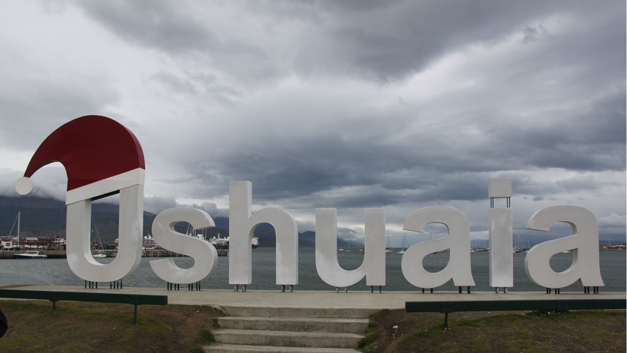
We flew south from Buenos Aires, Argentina to Ushuaia, Argentina – the southern most city in the world – located on the Beagle Channel – a more southern passage around South America than the famous, more northern, Straits of Magellan discovered earlier. After arriving at the airport, we walked briefly around town and got a local beer call a “Beagle”. The “Beagle” was the name of the ship that Charles Darwin was on with Captain Fitz Roy, when he visited the area in the 1800’s. The city’s name “Ushuaia” is Yamana for “Bay facing the sunset”, and the town sits nestled on the southern shore of the Tierra del Fuego island, just east of the dividing border with Chile, and on the channel that serves as the southern border with Chile. These borders were historically disputed between the two countries until the Pope intervened and set the agreed upon borders of today.
The town originally served as a Spanish penal colony founded in 1902. Then President Peron closed the prison in 1942, and the old prison now serves as a set of museums. In those days, the prisoners survived on sparse ship deliveries, and whatever fish and sea lions that they could catch, and many of them stayed when the prison was closed. In this area south of the east-west Darwin Mountain Range, the winds are very strong and out of the west making all aspects of life difficult. Before the new airport was completed in modern times, airplanes would get pushed off into the channel from the old north-south runway.
After World War II, the town was a key base for the Argentine Navy. The Military Dictatorship in the 1980’s was struggling with a great deal of protests and unhappiness of the Argentine people, and in 1982 demanded that Great Britain cede the Falkland Islands to Argentina. Although long-claimed by Argentina as “The Malvinas”, the British had colonized the Falkland Islands and had supported them continuously. The British refusal resulted in Argentina declaring war on Britain in April 1982.
To better understand this bit of their history, we sat down in the afternoon with “Daniel”, an Argentinian Navy veteran of that war. Daniel was a young 19-year-old gunnery crew from Buenos Aires assigned to the “Hildago”, a former WWII & Korea USA “730” Destroyer. Argentina had purchased the old ship in 1970, but it was originally commissioned in 1940. Daniel’s ship left Port Arenas on March 30, 1982 with no knowledge of what their mission was, and immediately headed to the Malvinas in a support role for troops that were sent ashore there. Only once underway were they told that Argentina was taking the Malvinas back from the British. The young sailors were shocked and surprised, but they were proud and excited. As a support vessel, they backed up the ships that had arrived to take the Island’s port where there were ~300 civilians living. The first death came soon thereafter – an Argentinean Commander. However, they took the port and had expectations of success and a quick victory when no more troops or ships arrived.
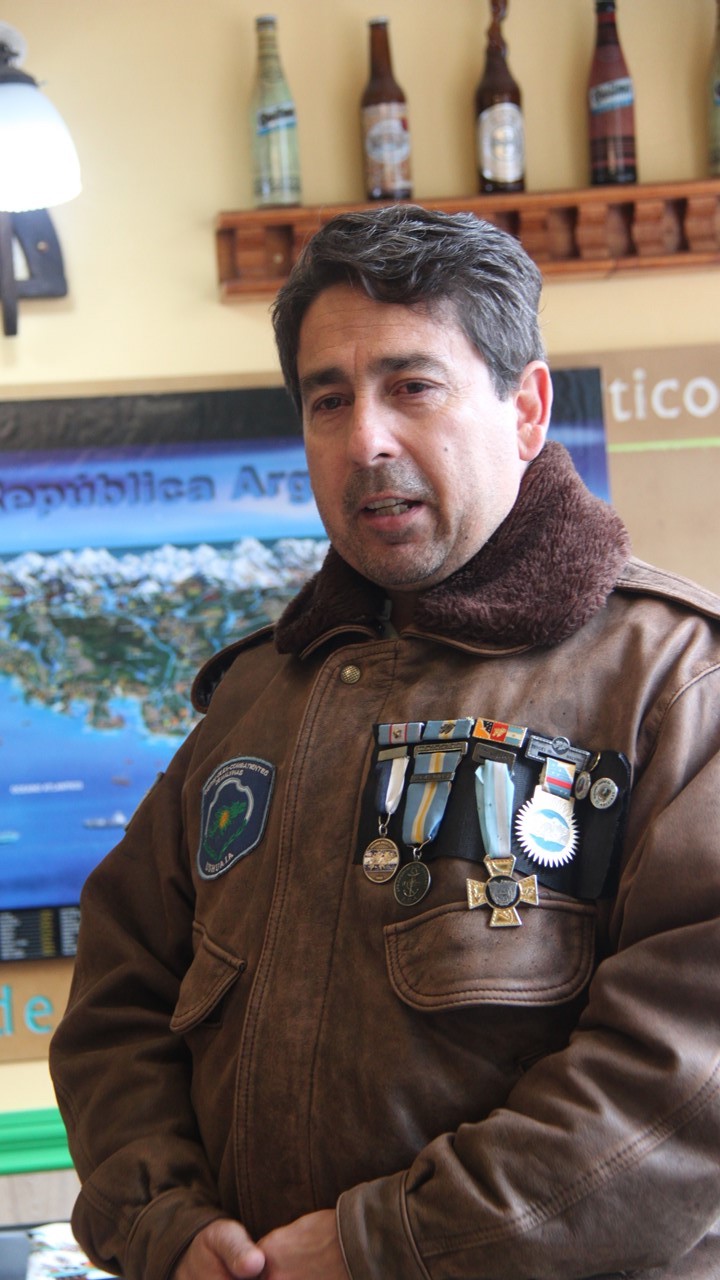
Soon thereafter, the British announced a 200 mile “exclusion zone” around the islands and backed it up with the British Navy. On April 11th, the Hildago had a mission to the south to protect communications’ lines and support another Destroyer in a planned Argentinean attack on the British. The Argentineans moved inside the exclusion zone for the attack, but, at this time, the South Atlantic was very rough, and the Argentinean Navy lacked the technology to coordinate an attack in such bad weather, and the attack was cancelled. While coming back to position outside the exclusion zone on May 2nd at 4pm just before dark, the “Submarine Attack Alarm” went off and the crew scrambled to their positions. Daniel worked in the forward “Combat Tower” as part of the artillery. He was heading to the restroom when the alarm sounded, and as he ran for cover, he could hear the torpedoes bypass their ship. Instead, their sister-ship was hit! They began anti-submarine maneuvers throwing depth-charges overboard, but the seas were over 25’ high and they did not have the technology necessary to be effective. Their sister ship began to sink with all 700 crew aboard, but the Hildago was ordered to leave the exclusion area immediately. After 10pm, they returned to the area to look for survivors. On the next day they found their first raft of survivors, terribly hurt and burned with petrol and with body parts missing. It took them many hours to rescue all the survivors, working against the clock in terrible weather. In the end, they rescued 277 survivors, but their ship was only a crew of 300 and their ship was overcrowded to the extreme with 577 now aboard. Those aboard gave the injured everything they had – food, beds, clothes, medicines – whatever it took – still today those involved remember how awful and bad it was. When the ship returned to Ushuaia, they began to receive news via the local radio stations saying that Argentina was winning the war, which those aboard knew wasn’t true.
Daniel’s family had no knowledge of either himself or his 17-year-old brother who was also at sea in the Navy. The lack of information and the lies that the dictatorship was telling made it a very difficult time in the country. The rendition and the end of the war was on June 14th, and when they returned to their home port, there was no one their to greet them or welcome them home. The most difficult moment of all was when he finally got to see his father whom he hardly recognized. His father has lost a great deal of weight and had aged considerable in such a short time with worry and grief over the unknown fate of his two sons. When Daniel returned to his old neighborhood in Buenos Aires, neighbors would come up to touch and hug him. Daniel remained on the Hildago until 1983 and retired from the Navy in 1984. He moved to Ushuaia and works with the many local veterans that retired there. Last year 120 veterans died from cancer, heart attacks, and suicide. He received medals for Combat, the Presidential Medal, and the Province’s Remembrance 35th Anniversary Award. His final comment was:” We went as hero’s but came home through the back door“
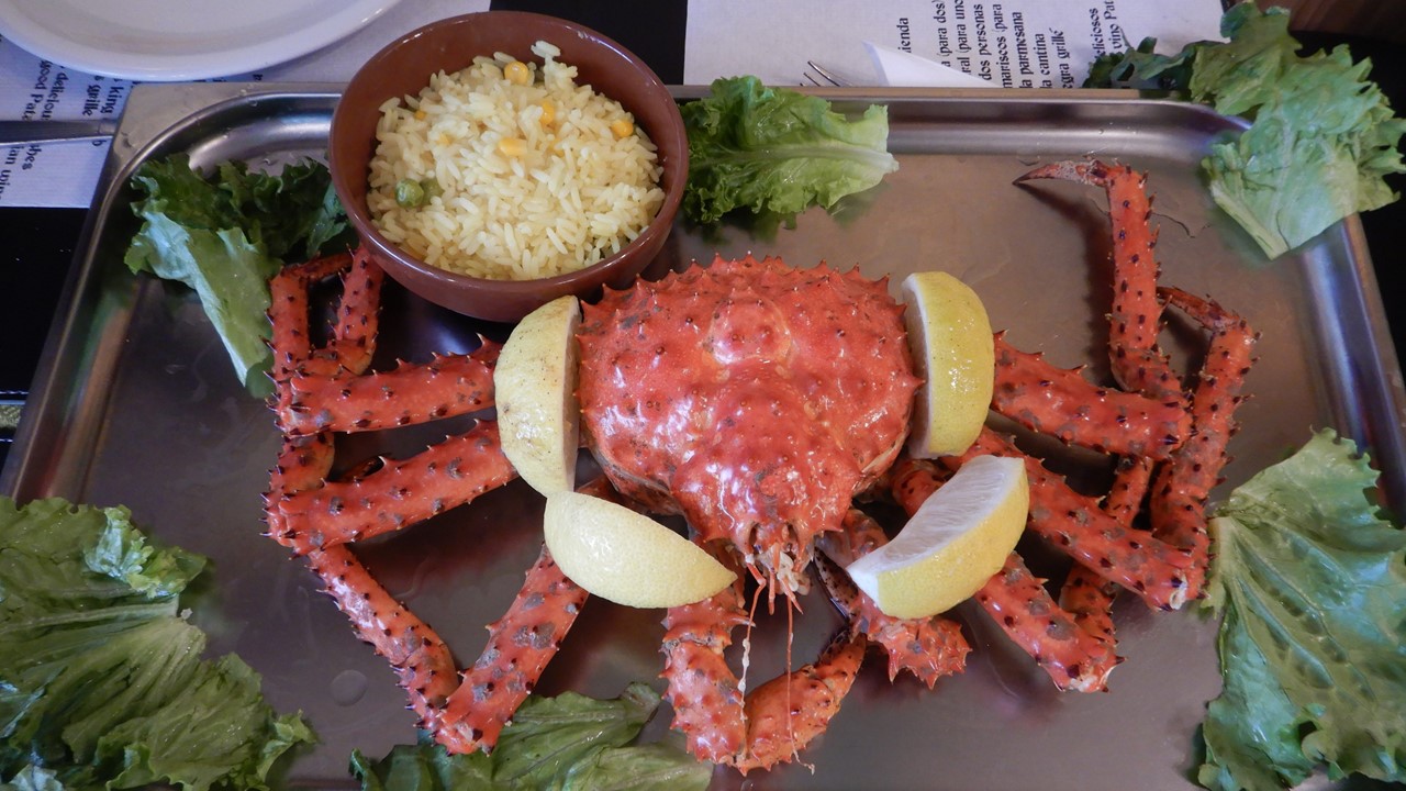
After such an emotional engagement, we stayed for a group dinner at “La Cantina de Freddy”. There we had crab soup followed by whole king crab with butter, rice and french fries. Dessert was a bonbon with Patagonia Calafate berry ice cream – an amazing meal!
Wednesday morning, we walked to the nearby former Ushuaia Prison, which houses 4 interesting museums in the radial arms of the former jail-block’s: the Argentina in Antarctica Museum, the Military Prison Museum, the Ushuaia Jail Museum, and the Naval Models Hall. After the tour, we walked down the town’s main street, San Martin Street, for some shopping, (they have a Hard Rock Café)!
For lunch, we visited a local couple, (Gaby & Gustavo), who are raising their two daughters, (Lara – 7 and Sol – 12), in a nice home up on the side of the hill overlooking the town. We explored their home and learned about their lives here in Ushuaia. There were both in the travel agency business and enjoy meeting travelers from around the world. For lunch we had lentil stew and spinach cheese biscuits with milk cake and meringue, and brownies with caramel and chocolate for dessert. After lunch, we had a lively discussion about the building of their house, family, education, and the custom of mata – a tea-like herb that is mixed with hot water and sipped through a filtering straw. It is the most common form of greeting and social interaction among Argentineans.
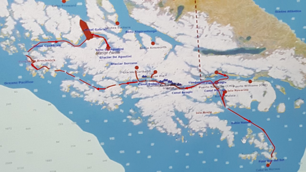
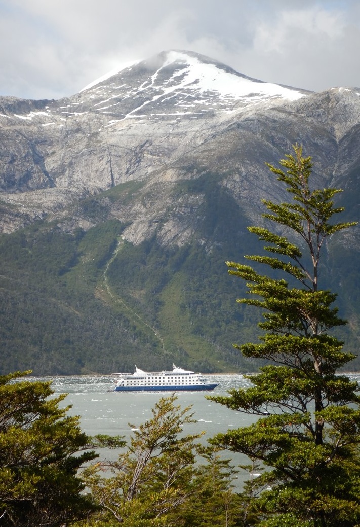
After lunch, we visited the Tierra del Fuego National Park which makes up much of the island. It was created by Francisco Murano and was the first national park in Argentina created in 1960. Today, one of the park’s glaciers is named after him. Argentina and Chile share the 3rd longest border in the world and the island is shared between them. The road, Route 3, is part of the Pan-American Highway stretching over 28,500 miles from Alaska through Buenos Aires to its ending in the park. After walking to “The end of the Road” we visited Ensenada Bay Post Office and received passport stamps marking the occasion. We then hiked through a series of trails that took us through forest of beech trees, gave us great views of the east-west Darwin Mountains, and the Andes in the distance, and took us through sub-arctic meadows. The beech trees here are not true beech trees, and as called “false beech trees”. The can grow to 100’ high and can live up to 500 years. There are three types, including one that stays evergreen throughout the winter. We then took a hike along Lake Acigami, (Lake Roca) where we were in sight of the border with Chile. We then made a brief visit to Lapana Bay, a “false” lake that is actually part of the Beagle Channel. We then returned to Ushuaia to board our ship, the Stella Australis – our home for the next 5 days.
The ship had large guest rooms with good size private bathrooms. There was an open, outdoor viewing deck on the sixth level, and a large comfortable indoor lounge (Darwin Lounge) with open bar and an outdoor stern viewing deck on the fifth level. The fourth level housed the Bridge and had a smaller lounge (Sky Lounge) with staterooms, as did the third level (Yamana Lounge). The second level included the Reception Desk, Gift Shop and more staterooms, and the 1st level were crew quarters and the kitchen and dining room. There were many screens around the ship with activities listed, as well as a GPS tracking of our route. Meals were at 8am, 1pm and 8pm. All excursions would depend upon weather, wind and waves, but, in general, there were two planned every day! We left port and made our way south into Chile and out of the Beagle Channel, heading for the famous outpost, and our first tentative excursion in the morning – Cape Horne!
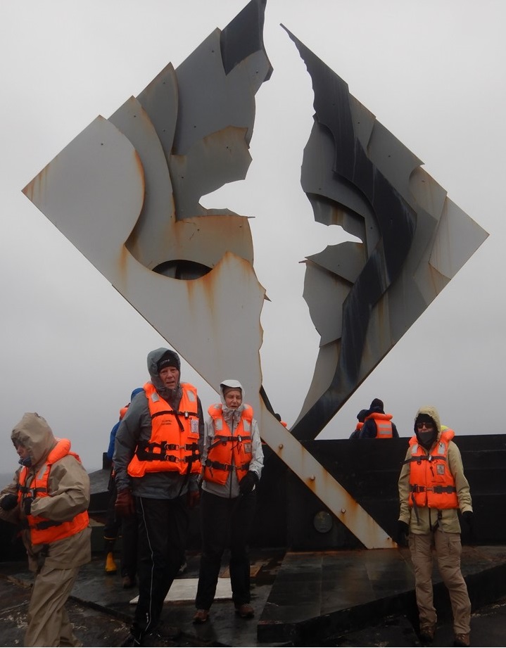
These islands became a National Park in Chile in 1945 and became a UNESCO World Heritage site in 2018. Cape Horne is the most southern inhabited place in the world (other than Antarctica), and the lighthouse there is manned by a Chilean Service man with his wife and children. Cape Horne is still 593 miles from the Antarctic peninsula and is renowned for the more than 800 documented shipwrecks that have occurred there, and the over 10,000 sailors who have died trying to round its point. The seas and weather here are highly variable, and our likelihood of being able to make a landing tomorrow is only 50-50%.
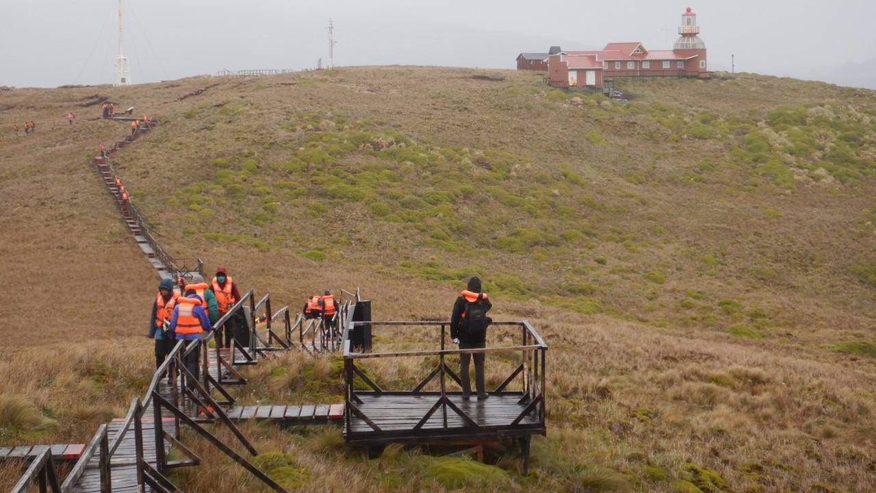
On Thursday morning we are lucky and the seas (4-8 ft) and wind (20-35 knots) are manageable, although it is cold and raining and sleeting. Before breakfast, the crew lowers the six 10-man zodiacs that are carried on the top deck, verify the safety of the landing, and begin taking ashore 10 at a time. We are in the last group of 30 planned to disembark, and while we are waiting, the wind picks up and the seas grow. The Captain begins to get worried, and although he allows us to travel to shore, he cuts short the visit of the passengers already on shore so that he can begin to bring them back to the ship. We make it to shore for a strenuous 120-step climb up the hillside to the Cape Horne monument to the lives lost there, braving winds in excess of 40 miles-per-hour, protected in our layers of waterproof gear. After making it to the top, we do not have time to visit the lighthouse or the chapel, or visit the family living there before we begin our descent back to the boats to return to the ship. The weather continues to degrade, and we finally arrive at the ship in time for the Captain to lift anchor and head back north for the safety of the islands and to reenter the Beagle Channel.

After breakfast, we took in a film on Shackleton’s ill-fated journey to Antarctica and the South Georgia Islands which covered over 400 days of starvation, heroics, lost at sea, and frozen in ice – but with no casualties! A true miracle! After lunch, and in better weather in the Beagle Channel, we again boarded the zodiacs, and headed to shore in Wulaia Bay – the site of an historical house from the 1930’s that served as an old radio station of the Chilean Navy, and that was put here to support their claim to the area.
Inside the historical house was a big barrel that visitors could deposit post into, and from which travels could take post out under the condition that they would see that it was delivered. This was the typical postal system for many years for the sailors that passed through this region and were away from home for years. Beyond the house was a series of optional hikes, and we took on the “Demanding” one that entailed climbing the local hillside through beech forest and over rumbling streams to an 800’ high lookout with a view over the Bay. The 16 of us trekked for over an hour, up to a spectacular location where we sat silently for minutes enjoying the view and the sounds of nature. Along the way, our guide, Luciano, related the story of a Yamana local boy named “Jimmy Button” by Darwin, and taken by him to England to be “civilized”. For 2-years, Jimmy was the hit of London, learning English and aristocratic customs, wearing fine clothes and even meeting the Queen of England. When Darwin then brought Jimmy back to Wulaia as his emissary to convert the natives, the Yamana, to Christianity, Jimmy disappeared for some time, but when Jimmy finally reappear, naked, with his mother and tribe-folk, he told Darwin that he would always be the son of his mother, and he would always remain Yamana. Jimmy left behind his fine clothes, his “civilized” customs and left with his people to never be seen again

Today, the island has issues with mink, beaver and rats, all introduced by European settlers and trappers into the area for which no natural predator exists. The beavers were brought from Canada to start a fur industry, but with no predators and a different climate, their coats changed making their pelts worthless. After making the equally difficult climb down and returning to the dock to board our zodiacs, we were greeted with hot chocolate with a shot of whiskey. Then it was back to the ship for showers, a dinner of beef tips or spaghetti, and a movie called “Living on the Edge” about life of the penguins and seals in the area.
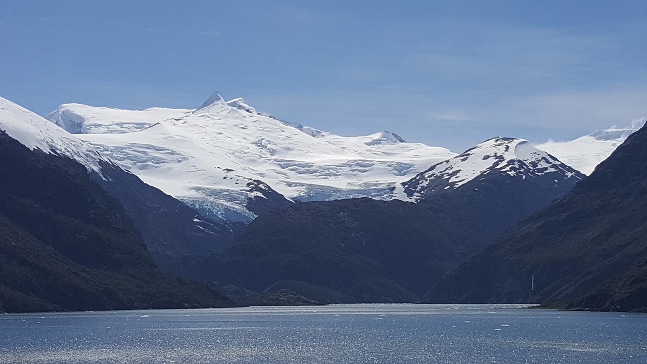
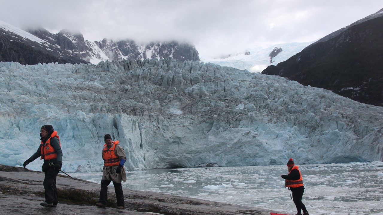
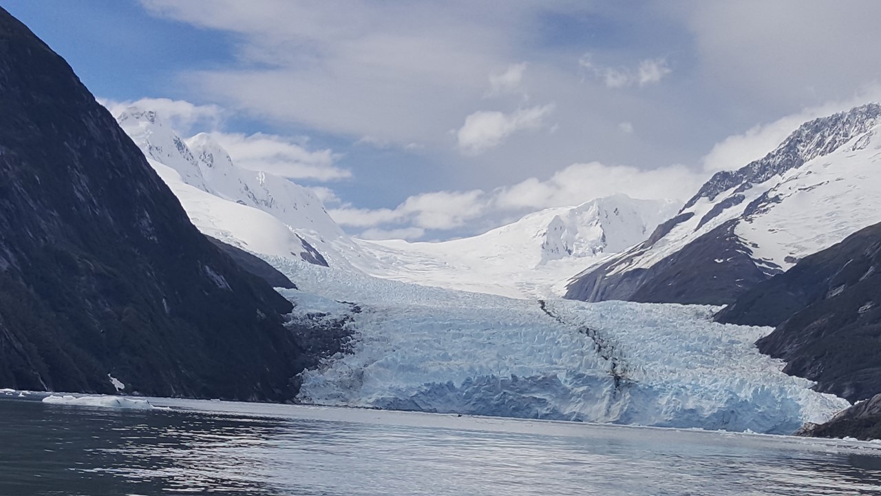
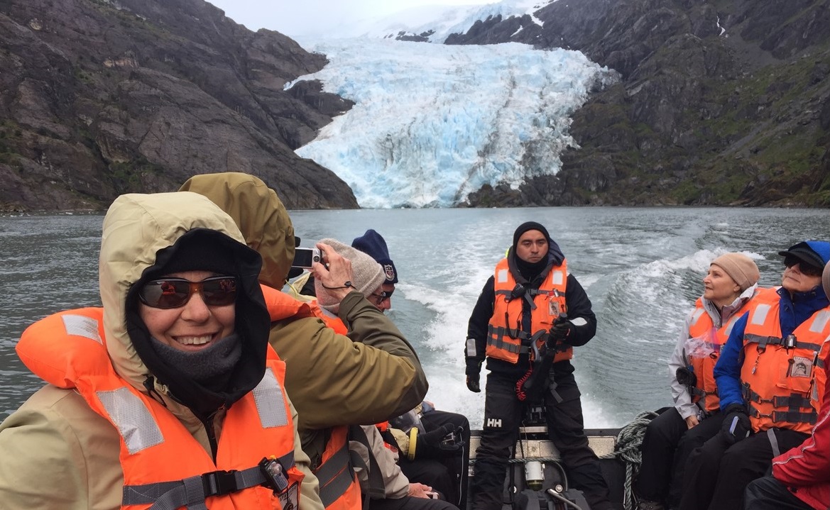
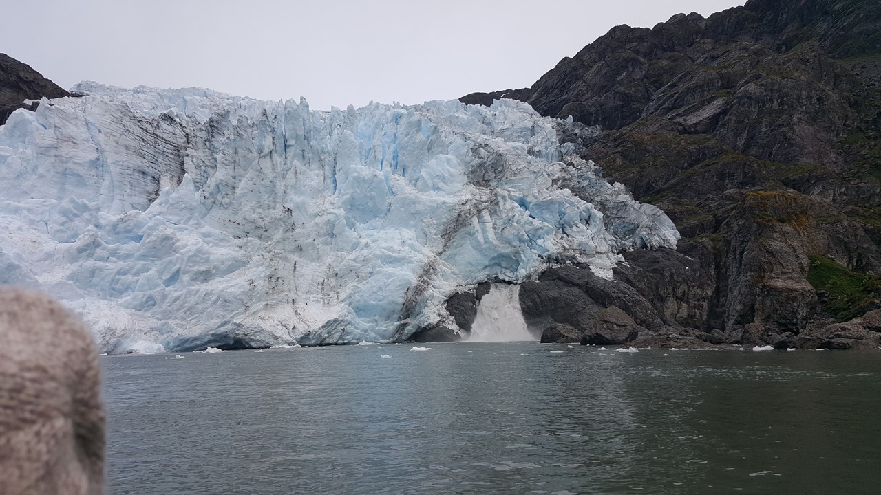
On Friday, we were well into the Darwin Mountain Range, and are greeted at every turn with soaring mountains, glistening icefields, and glacier-filled valleys. After breakfast, the ship set anchor, and we boarded our zodiacs to go ashore and explore the Pia Glacier. This glacier is a tidewater glacier that, along with many of its neighbors feed an enormous number of icebergs floating around the ship and among the zodiacs. The calving takes place on this glacier every 10-15 minutes, with a multitude of loud cracks and pops in between. Our zodiac maneuvers through the ice floes before landing us on a large rock positioned on the side of the glacier-carved fiord, just a few hundred yards away from the glacier’s blue-ice face. From here, we spend some time watching and observing as ice chunks drop off into the sea with a thunderous boom. The Pia Glacier if slowly receding, but not at a steady rate, as it is highly dependent of the amount of snow in the icefield feeding it that falls on a yearly basis. Many glaciers in the Darwin Range are, in fact, growing, or are stable. To the one side of the Pia Glacier is the Sinos Glacier – a hanging valley glacier that does no longer reach the sea, and which consists today of a massive ice sheet covered with rocks and dirt, obscuring the view of the ice below it. After a bit, we climb a few hundred feet up to a better viewpoint where we can observe the glacier. For the first time of the day, the sun came out making the ice sparkle. We finally left to re-board our zodiacs, enjoying our customary hot chocolate with whisky at the shore first.


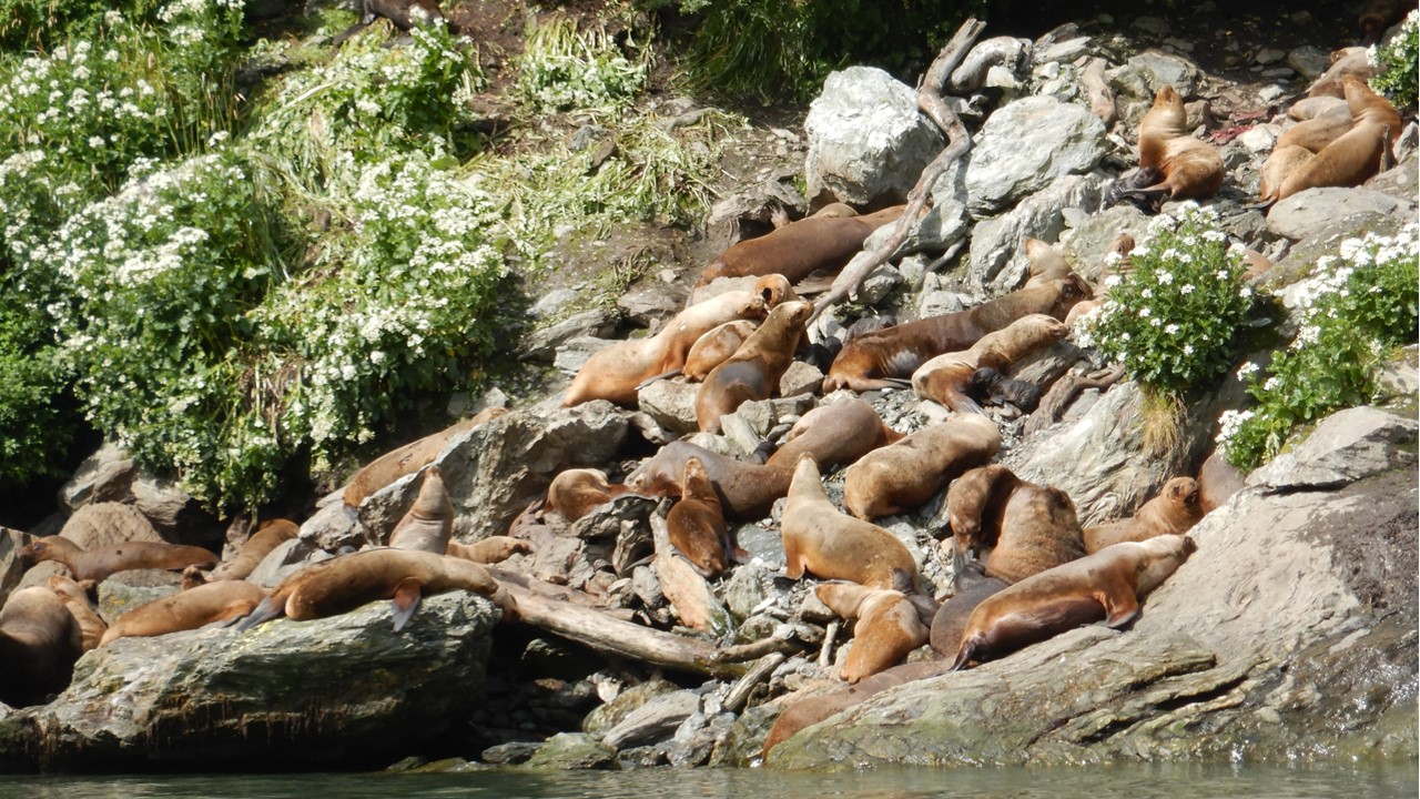
After raising anchor, we began a journey to our next fiord. During lunch, the number and size of the icebergs grew tremendously, and the Captain announced that we would not be able to maneuver any closer to our destination, the Garibaldi Glacier, and he set anchor. Although this would mean that we would not have enough time to take everyone to shore, we would still be allowed to board the zodiacs for a boat-ride to the fiord and to approach the face of the glacier. The Garibaldi Glacier has receded almost ½ mile from its terminal moraine, which makes a natural levy at the exit to the fiord. However, there is enough room for the zodiacs to enter the fiord, and to avoid the rocks and the kelp beds that flourish in the perfect mixture of water from the sea and melt from the glacier. The glacier has been stable for the last 75 years, but no one knows exactly why. After enjoying the view at the face of this tidewater glacier, we began our trip back and ran across two large pods of sea lions on the rocks on the shore. Each pod had a dominant male and a hareem of females, many of which had either just given birth, or who were in the process. The birthing activity and the tiny black pups attracted the interest of a flock of predator birds that circled low overhead. After getting as close as we dared for pictures, we returned to the ship for drinks, dinner, and a movie, “Fire & Ice”.
By Saturday morning, we had traversed the Cockburn Channel and entered De Agostini fiord and the De Agostine National Park. After breakfast, we set anchor ourside the Condor Gracier terminal morraine and prepared to board the zodiacs. In the early 1900’s, the Condor glacier extended to front of the bay and was stable but beginning about 70 years ago it began to melt rapidly and recede, and did not reform, as many of the other glaciers did. A huge waterfall pours from underneath the glacier as the water carves its rivers underneath the ice. It is still not understood why some glaciers in this region are growing, some are stable, and others are receding, such as the Condor Glacier. On the return to the ship, we saw several cormorants as well as some small kelp geese.
After lunch, we moved briefly to the entrance of the Aguila Glacier and assembled or small group oshore for a hike along the beach created from an ancient terminal morraine. The morraine formed a high arc nearly a mile long and 100-200 yards wide, but it was densely populated with trees, bushes, flowers and berries such that we needed to hike around the terminus end of it and back around the inside of the arc to a protected bay fed by the Aguila Glacier Although the Aguila Glacier appeared to terminate into the bay, it was actually sitting on a bed of rock and had been stable for as long as anyone has recorded it. We hiked up to near the glacier’s face and observed the rocks and cavern along the edge of it After taking a small “nature walk” through the dense nearby forest, we hiked back the way we came for our “post-hike-treat”, and our trip back to the ship.

Saturday night, the ship would exit the Island Channel’s and enter into the Pacific Ocean, before entering the Straits of Magellan at it western end. The Straits of Magellan is 310 nautical miles long and was the primary route for the transport of goods and people to a growing California and USA West Coast until the Panama Canal opened in 1914. Early Sunday morning, we will pass Cape Forward – the southern-most point along the Straits of Magellan route. Then we will head north within the Straits until we reach our final destination port – Punta Arenas. We feel the rolling of the ship in the night and we arise early to see the sights, but we are disappointed to find the we are setting anchor just off the port. During the night we lost one of the ship’s two engines, and the ship can travel no further. We had hoped to get a chance to visit nearby Magdalena Island – home to over 60,000 penguins. However, it was not to be, and when repairmen were unsuccessful, we were forced to wait for tugs to come and push us in to the wharf. While waiting, we were fortunate to spot a number of whales spouting in the area, which kept us entertained until we finally departed the ship at noon. By the way, the problem was so serious that the next two trips on the ship had to be cancelled.
As an aside, Magdalena Island is a Chilean National Park where penguin colonies can be observed close-up. There is a coastal path to the lighthouse (~850 meters hike) where the Magellanic specied of the 17 different species of penguin can be found. They are not too tall (50-70 centimeters) and can live up to 20 years. They typically weigh 3.5-5.5 kg and are heavy and dense. Their chick is grey and fluffy and does not develop it characteristic marking until it is past 3 years and becomes a full adult. Penguins spend 80% of their time in the water, and the 20% of the time on land is for molting, birthing and caring for the chick. They waterproof their feathers with an oil they secrete and must be ever vigilant onshore for bird that will attack their eggs and chicks, and in the water where seals and whale seek them for food. Fishermen used to use them for king crab bait in the crab traps, but that practice is now illegal. The breeding males arrive on the island early in September and begin to make their nest in preparation for the arrival of their partner (penguins mate for life). When the female arrives, she adds twigs, etc. and the couple engage in beak kisses and vocalizations (raising their head in the air and making sounds like a donkey). They then mate, the female lays her eggs, and incubation takes 35-40 days, (both male and female care for chicks) Penguins eat just fish and squid and they molt once a year where they over feed, come to land and molt, and don’t return to the water till their new coat is ready.

After we leave the ship, we enter Customs, and then explore the town on Puenta Arenas. This Port was founded in 1520 on a strategic point (Puenta) of land along the Magellan Strait, Today, this southern Patagonia city houses 120,000 people of the 160,000 in the whole region., and is really the only large city in Patagonia. The City Square houses statues of statues of Magellan and Mermaids holding the coat of arms of Chile and Spain surrounded by natives. The area has a long history of influences from the British explorers and their navy and today still observe tea time. The main meals here are still lamb and potatoes and the town was beginning to make preparations for celebrating its 500 Birthday next year. However, we had a long bus ride ahead of us as we were traveling north in Chile to the Torres del Paine National Park – over a day’s travel away. Next stop – Puerto Natales!
We arrive in Puerto Natales by late afternoon. Puerto Natales is also on the Magellan Strait, but is a small town of only 21,000 people. It is a popular town for hikers and campers to kick off their exploration of Patagonia. We check into our waterside hotel, and head off to shop the Herman Eberhard Street crafts, shops and restaurants. This town has made all plastic bags illegal because of the strong and constant winds that make them such a nuisance. That night, we dined on salad, salmon and dessert before calling it a night, and getting ready to set off by bus again in the morning for our all-day bus ride to Torres del Paine National Park.