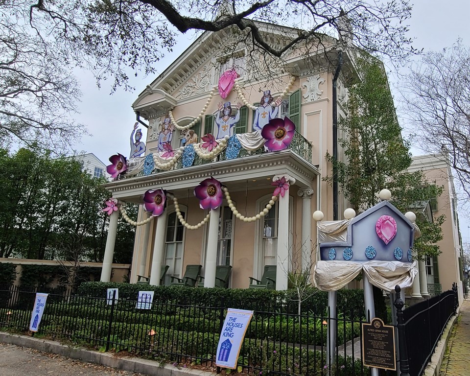
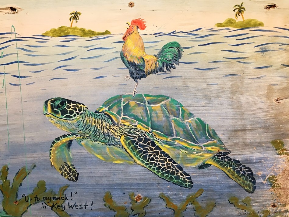
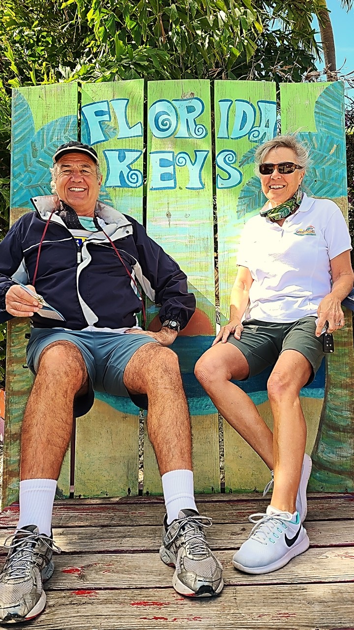
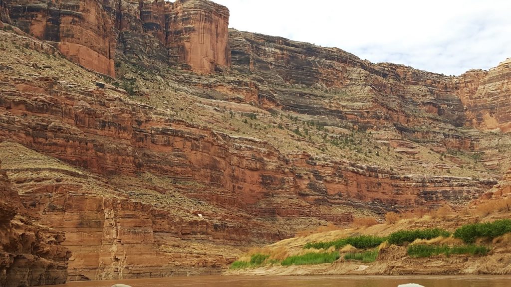
February 2021 found New Orleans still deeply in the midst of the Covid-19 Pandemic, putting the city in the difficult decision of having to cancel all Mardi Gras Parades, and even closing the downtown’s bars and restricting access to Bourbon Street. However, in the typical “can do” and forward-looking spirit of New Orleans, Mardi Gras would still be celebrated, and the colorful revelry would simply move to a different forum. One of the most novel concepts was to replace Mardi Gras Floats with Houses decorated to resemble the colorful, whimsical artistic mobile structures – e.g., “Yardi” Gras. This concept turned out to be so popular, (over 3000 houses in New Orleans registered to an indexed map), that the idea and celebration has moved across the country – and even the world – and is highly likely to be an annual event with growing recognition and awards. In fact, it was already apparent in New Orleans this year that paid tours of “Yardi” Gras homes for in-town tourists were already underway. This also had a great knock-on impact on the float-building and decoration Industry, as MG artists and companies were now being employed to design and decorate houses rather that floats.
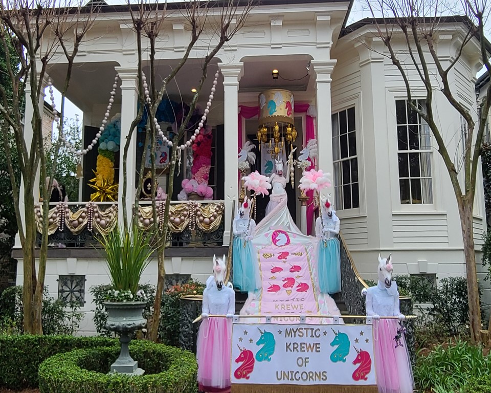
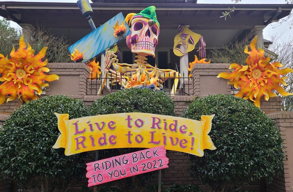
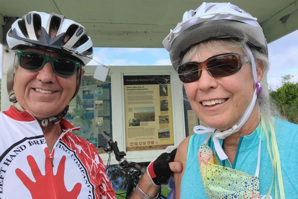
Since Mardi Gras Day 2021 in New Orleans fell on a day of record low temperatures, (26 degrees F), and dangerous conditions, we ventured out on the milder Sunday before Lundi Gras to capture some of the locally decorated houses and were not disappointed. Enjoy the small subset of the ~70 houses that we observed pictured here!
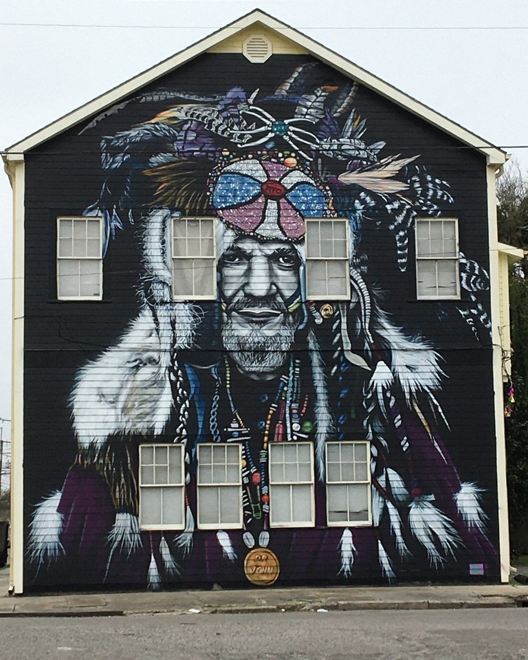
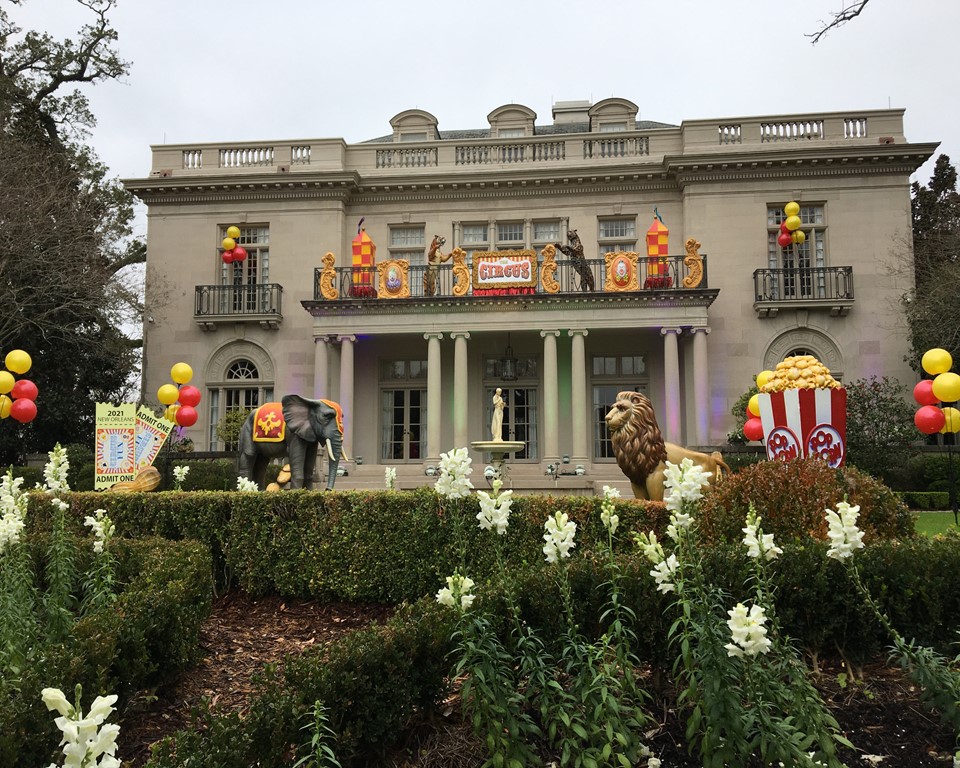
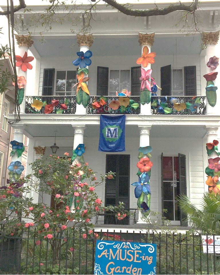
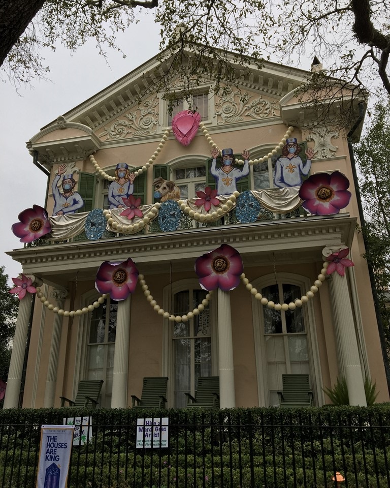
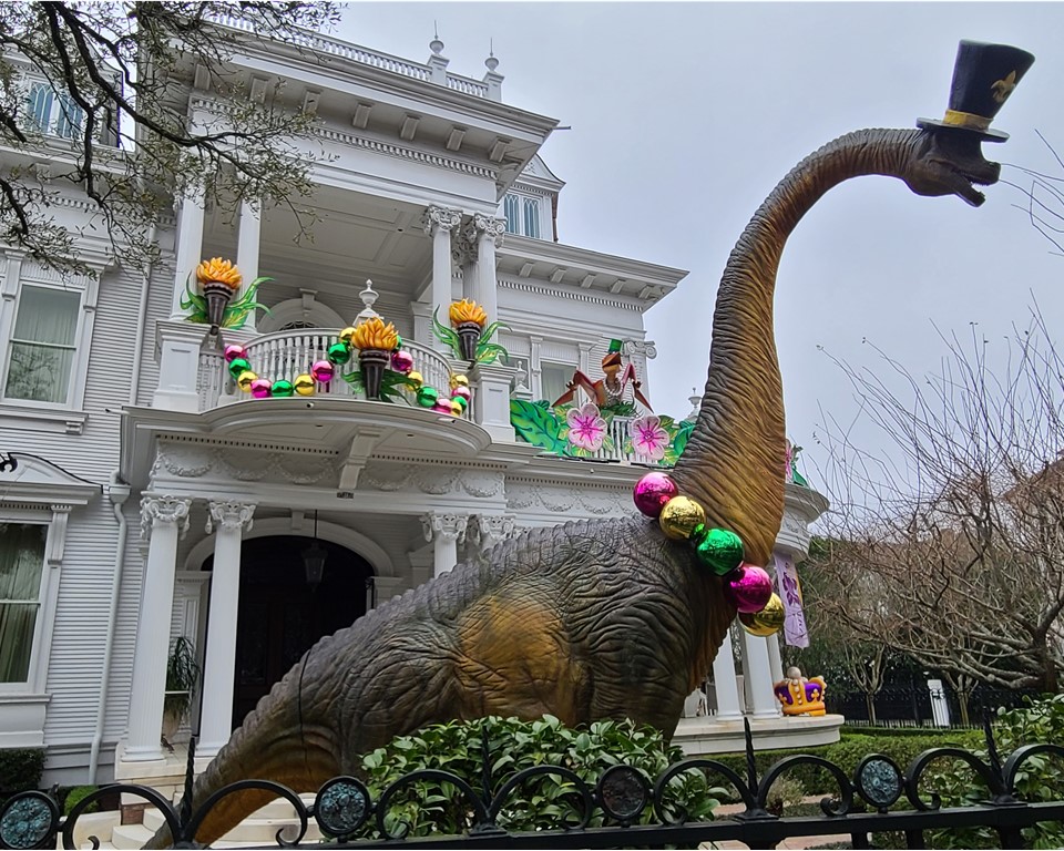
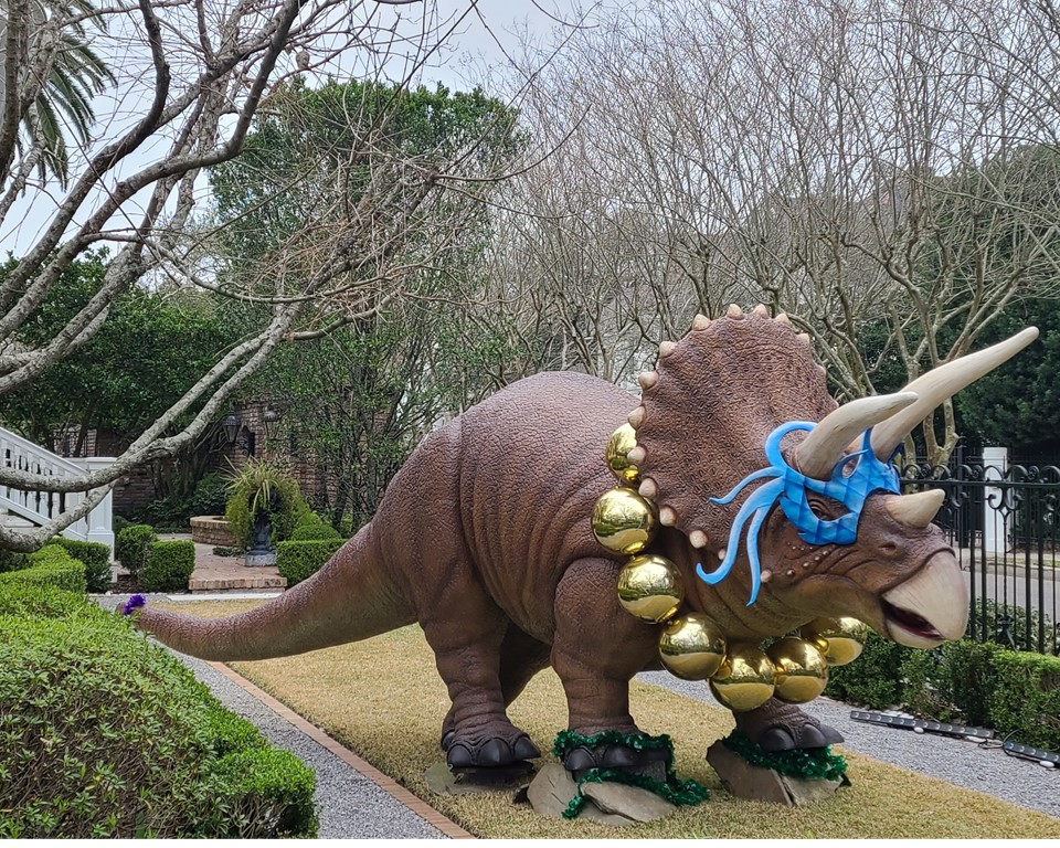
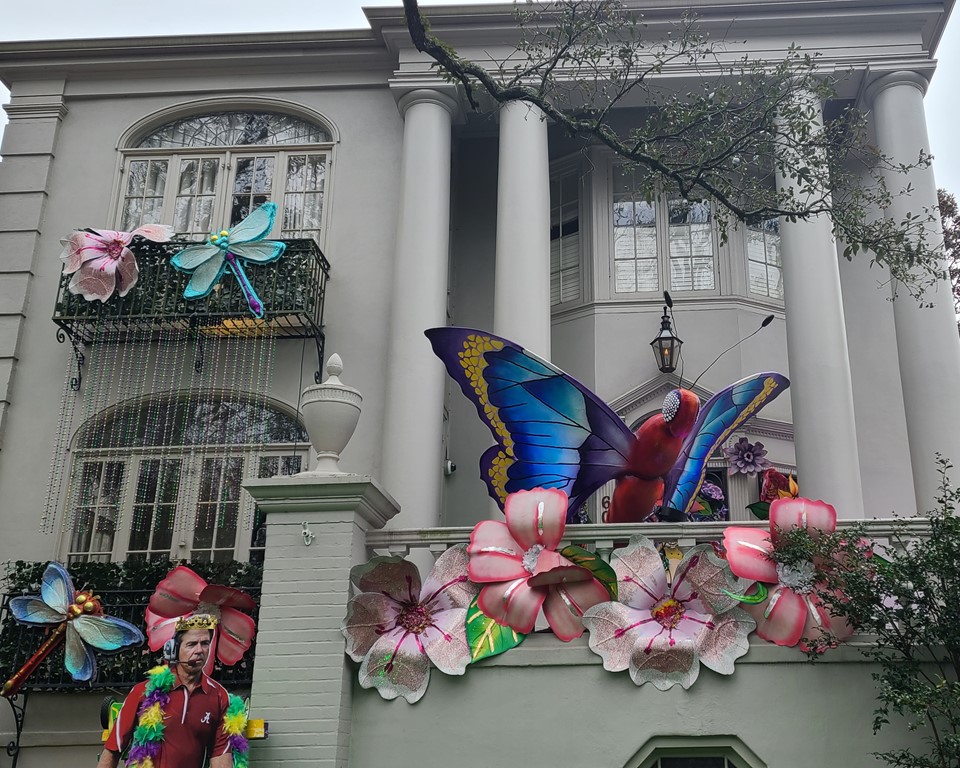
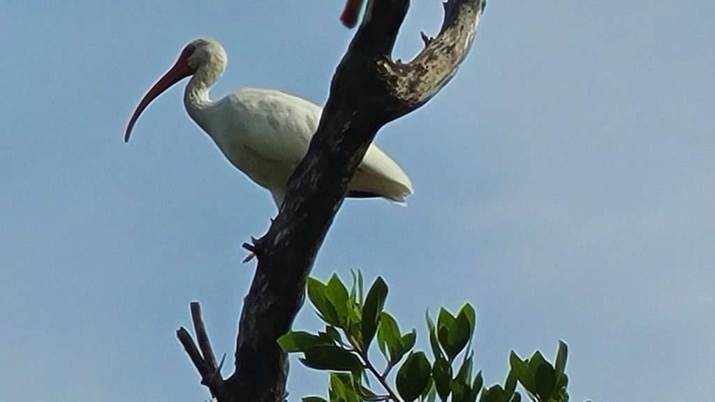
Endymeow 2021 – Cat Practice – 1809 Magazine StMF – Mignon Faget – Butterflies of Winter – House # 7 – 3801 Magazine StThe Night Tripper – House Float 1 – Honoring Dr John – 1834 Toludano StDr John – A Mural by Artist MTO – French Graffiti – 1801 Toludano StThe Circus “Animal House” – Kern Studio – 5531 St Charles StA MUSE-ing Garden – Krewe of Muses – 2800 St Charles StQueen Jubilee – House Float #5 – Krewe of Red Beans – 2701 St Charles StQueen Jubilee – House Float #5 – Krewe of Red Beans – 2701 St Charles StDr John – Lets Make it a Better World – 1629 Coliseum DrDino Gras – Brontosaurus – Kern Studio – 5809 St Charles StDino Gras – Triceratops- Kern Studio – 5809 St Charles StThe Fly – Kern Studios – St Charles & Webster StThe Fly – with Nick Saban – Kern Studios – St Charles & Webster StMystic Krewe of Unicorns – 4500 St CharlesLive to Ride – St Charles & 4th St
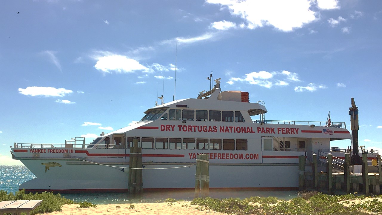
Thursday morning, we rose early and gathered in one car to hear down to the Ferry Terminal to park and check in for our trip on “The Yankee Freedom” – a 250-passenger (but only carries 175) Ferry under contract to the National Park Service to take passengers to the Dry Tortugas located 70 miles west of Key West. Boat or Seaplane is the only way to get to this National Park and the 2-hour Ferry ride offers glimpses of sea turtles grazing and a myriad of sailing vessels. The Ferry trip includes a breakfast, and a lunch once we arrive at the Island. It also provides snorkeling gear and serves as the only source of fresh water and for restrooms for the visitors to the island.
The Yankee Freedom Ferry
The Dry Tortugas are a series of small islands (once 11, but today only 7), that has an interesting history starting with their discovery by Ponce De Leon in 1513, and their naming for both the lack of any fresh water and for the large numbers of sea turtles that nested there. The current islands are:
Loggerhead Key, which is the largest island, has the highest elevation at 10 ft, and is home to the Dry Tortugas lighthouse.
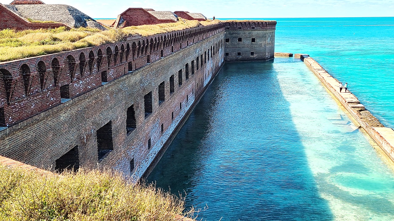
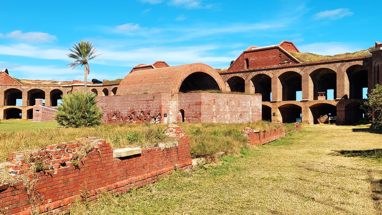
Garden Key, with Fort Jefferson and the (currently missing) Garden Key lighthouse located east of Loggerhead Key and the second largest island.
Bush Key, formerly named Hog Island because of the hogs that were raised there to provide fresh meat for the prisoners at Fort Jefferson, and which was currently attached to Garden Key via a sandbar. The island is the third largest and is the site of a large tern rookery, and is off-limits for half of the year.
Long Key is located at the eastern end of Bush Key.
Hospital Key, so called because a hospital for the inmates of Fort Jefferson during the Yellow Fever epidemics had been built there in the 1870s. The island was formerly called Sand Key. It lies about 1 ½ miles northeast of Garden Key and Bush Key.
Middle Key, which lies 1 ½ miles east of Hospital key and is not always above sea level.
East Key located a mile east of Middle Key.
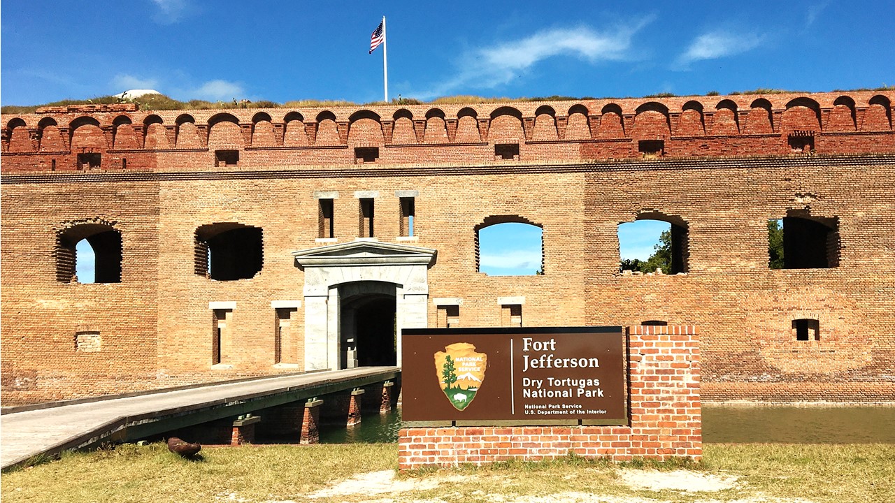
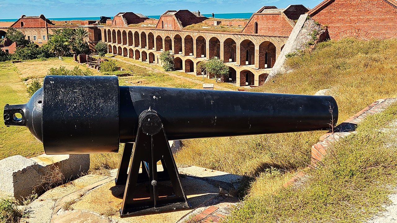
The area is known for its treacherous reefs, and in 1825 a lighthouse was built on Garden Key to warn ships and guide them toward safety. At the time shipwrecks were common, and with underwater wrecks dating back to the 1600s, the Dry Tortugas currently possess one of the richest concentrations of shipwrecks in North America. It is also because of these large reefs surrounding the Tortugas that the U.S. was able to establish one of the most strategic harbors in U.S. history, and the largest all-masonry fort in the United States, Fort Jefferson. Construction of the fort began in 1846, and although it was never finished after 30 years, the bastion remained in Union hands throughout the Civil War. With its 15-inch Rodman smoothbores guns, weighing 25 tons each, a crew of seven men could fire a 432-pound projectile a distance of three miles. The fort was later was used as a prison until abandoned in 1874, after suffering numerous bouts and high death rates from yellow fever and scurvy. Dr. Samuel Mudd, famous for being the doctor who treated John Wilkes Booth for a broken leg in the wake of the Lincoln assassination, was imprisoned here until early 1869. Also imprisoned was a leader of the “Chicago Conspiracy”, Englishman George St. Leger Grenfell, who is supposed to have drowned having escaped in a small boat. During the 1880s, the Navy established a base in the Dry Tortugas, and it subsequently set up a coaling (refueling) and a wireless (radio) station there as well. During World War I, a seaplane base was established in the islands, but it was abandoned soon thereafter.
From 1903 until 1939 the Carnegie Institution of Washington operated the Marine Biology Laboratory on Loggerhead Key. Through the years, over 150 researchers used the facilities to perform a wide range of research. The laboratory operated here, except for World War 1, until its closure in 1939. Fort Jefferson National Monument was designated by President Franklin D. Roosevelt under the Antiquities Act on January 4, 1935. The monument was expanded in 1983 and redesignated as Dry Tortugas National Park on October 26, 1992 by an act of Congress.
Fort Jefferson Sullyway on Dry Tortugas National Park
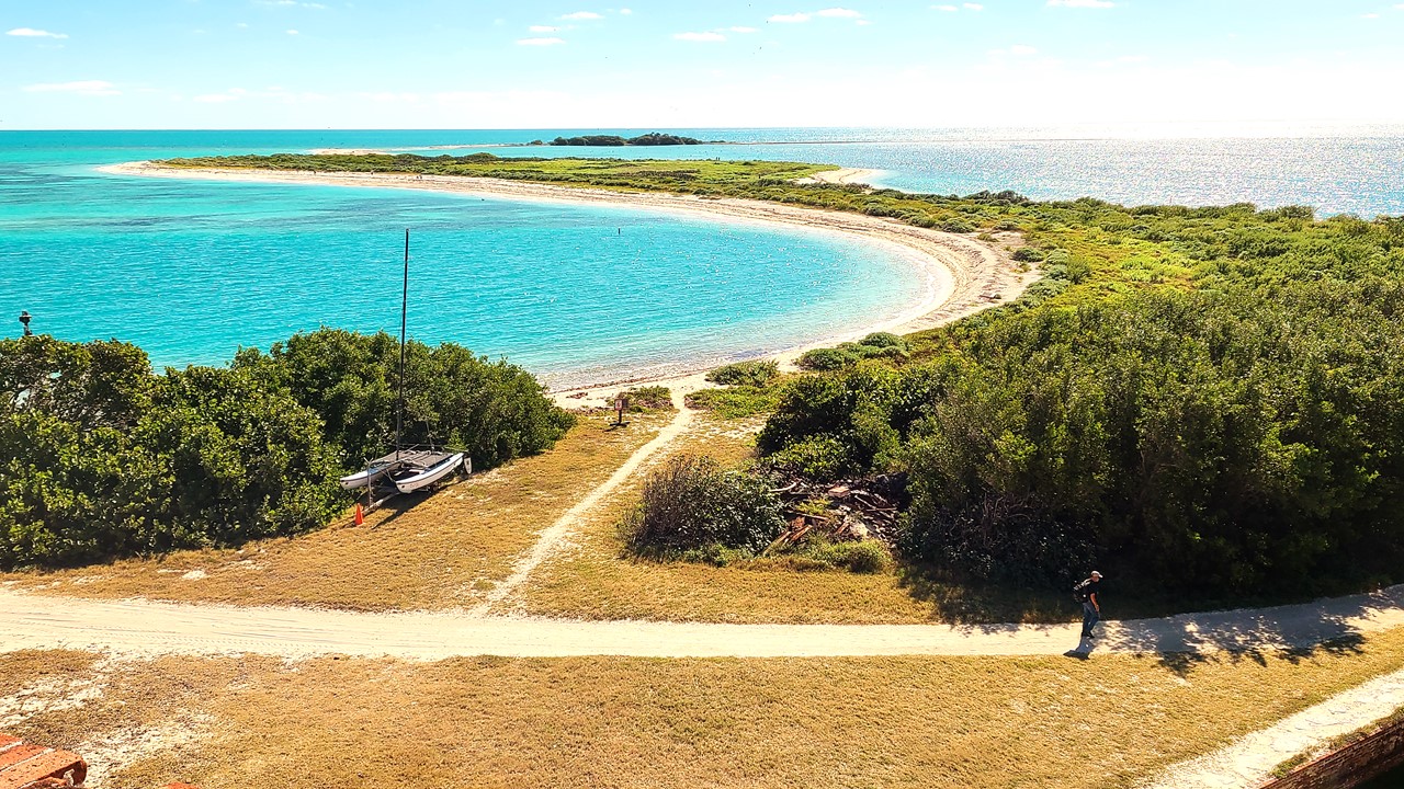
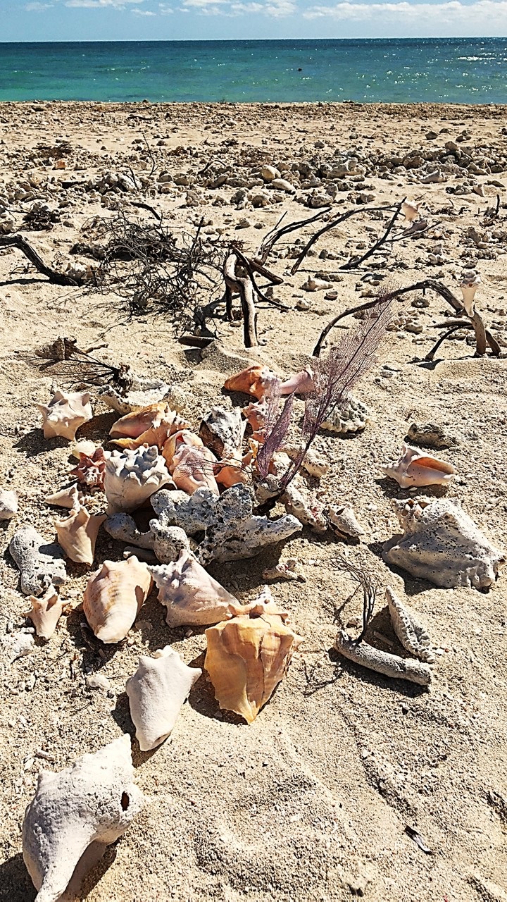
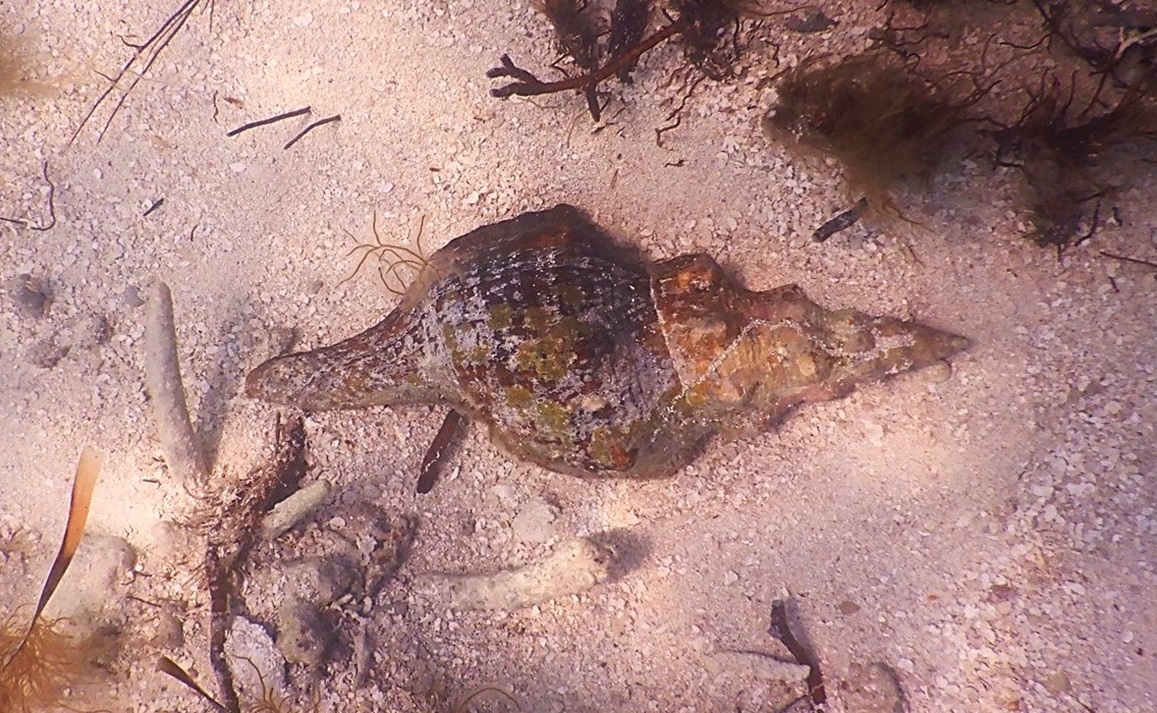
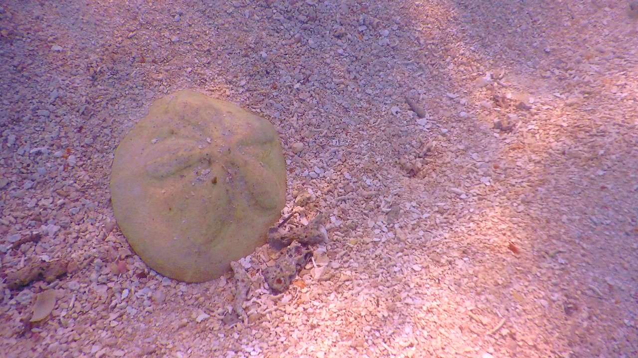
After we explored the fort and walked to Bush Island to see the rookery, we went snorkeling in the waters off the southern beach and explored the coral platforms and sea life along the moat wall. After lunch, it soon began time to board the Ferry for the trip back, which was uneventful. That night we picked up salads, but we could not use the hotel’s pool or hot tub, since unbeknownst to us, the night before, at around midnight, a car being chased by the police crashed through the hotel’s fence and pool bar demolishing the gazebo, bar, and part of the hot tub. Instead, we relaxed with a game of cards before beginning to pack our things for the next day’s long trip home.
15-inch Rodman smoothbores gunsThe Jefferson Fort MoatOne of the Two Powder Magazines6 View of Bush Key and Long KeyShells on Bush KeyJulie Snorkeling off South BeachA Two-foot Horse ConchA Six-inch Sea Biscuit
Friday morning, we checked out of the hotel and drove east an hour to the “Island Fish Company” for breakfast before beginning the additional 5-hour drive to our home in Indialantic.
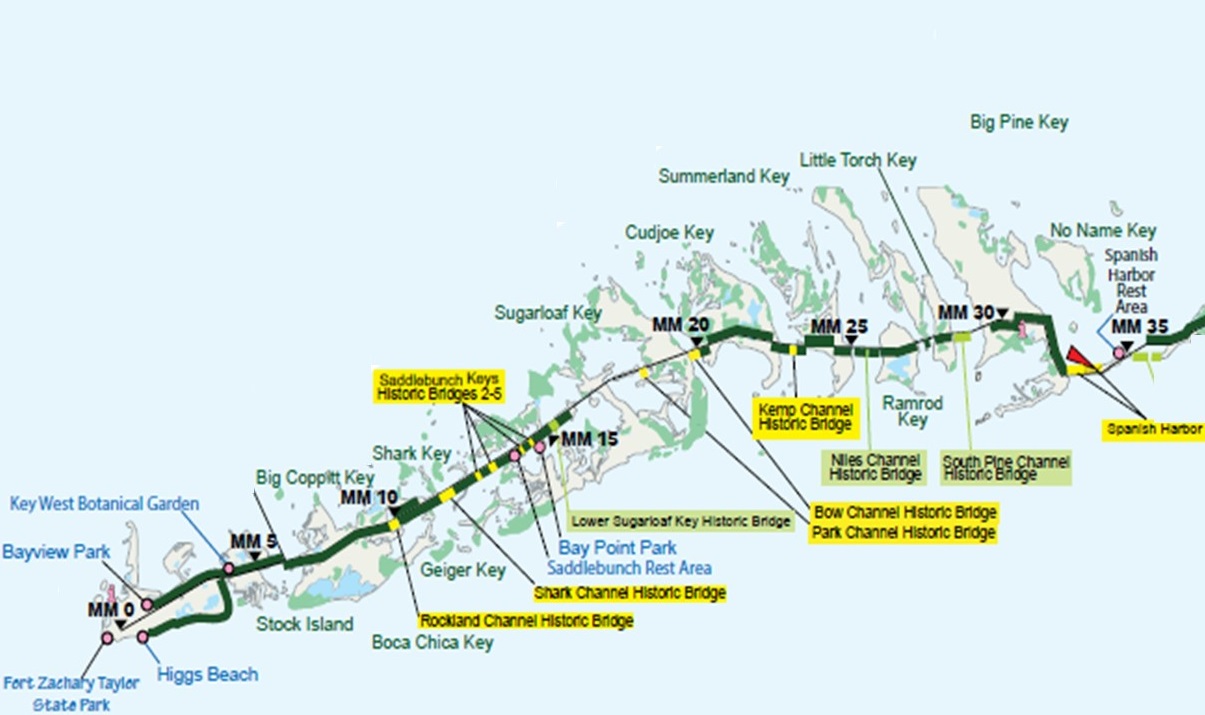
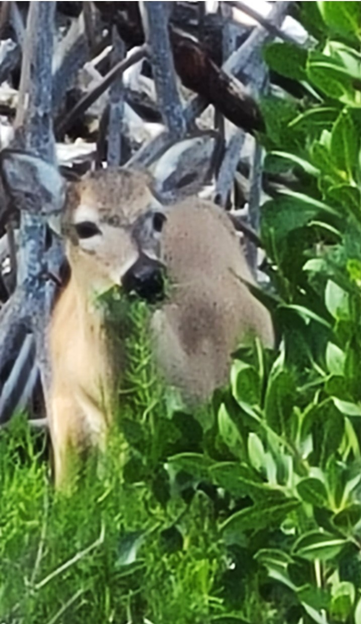
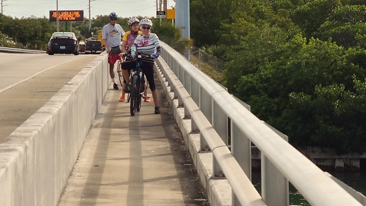
Tuesday morning, we were up for a hotel bag breakfast in the Hampton’s empty dining area before checking out and continuing our journey south by car to the southern end of Scout Key at Mile Marker 35 where we parked our cars to begin our next biking journey to the southwest. Unfortunately, it was quickly apparent that Julie’s rear bike tire was flat, so we pumped it up, saw that the leak was “slow” and began our journey anyways. The wind was still 17-20 mph in our faces as we rode over the bridge into Big Pine Key. Immediately we saw signs saying to “watch for Key Deer” as Big Pine Key serves as a National Wildlife Refuge for them.
Lower Keys Map
The National Key Deer Refuge was established to protect and preserve the endangered Key Deer and other wildlife resources in the Florida Keys. Although surrounded by salt water, it is the freshwater that helps to determine which species live and thrive in the variety of habitats. The endangered Key Deer is the smallest subspecies of the North American white-tailed deer. Poaching, road-kill, and habitat loss had reduced the number of Key Deer to only a few dozen animals by the 1950’s, but establishment of the Refuge and subsequent listing of the deer as endangered in 1967 has allowed for protection and a dramatic recovery of the species.
We turned our bikes left down Long Beach Road into the Refuge and rode 2.5 miles to the end of the road looking at the wildlife and soon came upon a small herd of 5 Key Deer foraging on the edge of the mangroves. After watching them for a while, we returned to U.S. 1 and stopped at the local marina to air-up Julie’s tire, use the restrooms, and then continue our journey. In this area, we rode on the shoulder of U.S. 1 as the entire route was fenced and every driveway and cross street was “cattle-guarded” to prevent deer from migrating or getting on the road. Once we entered the center of town on Big Pine Key, we came across Big Pine Bicycle Shop and decided to get Julie’s tire fixed. While they replaced her tube, they gave us a temporary “loaner” bike and we went to the nearby “Keys Café” for coffee. By the time we finished and returned, the repair was complete, and we resumed our journey – now heading almost due west with the northwest wind on our shoulder. After crossing short bridges to Little Torch Key and Middle Torch Key, we rode over a high-rise bridge onto Summerland Key where the were greeted with a wonderful paved away-from-the-highway bike route along “Old State Road 4A”.
Key Deer in Wildlife Refuge on Big Pine Key
State Road 4A was the first Overseas Highway which consisted of two roadway segments (a north segment at Key Largo, and a south segment from No Name Key to Key West) completed in 1928. In the 1930’s, World War I veterans were sent as part of the Emergency Relief Administration to work on new bridges to close all of the gaps that remained between the Keys. However, the 1935 Labor Day hurricane killed more that 400 of the workers and their families and severely damaged the highway and the Florida East Coast (FEC) Railway. The local county (Monroe) voted to only rebuild a highway, and conversion of the Bahia Honda trestle and building of connecting bridges began again. In 1938, the last connecting piece – a toll road between Matecumbe Key to Big Pine Key – created the first continuous road from Miami to Key West. During World War II, the Overseas Highway was straightened and moved leaving portions of State Road 4A abandoned, part of the local streets or available as a bicycling route.
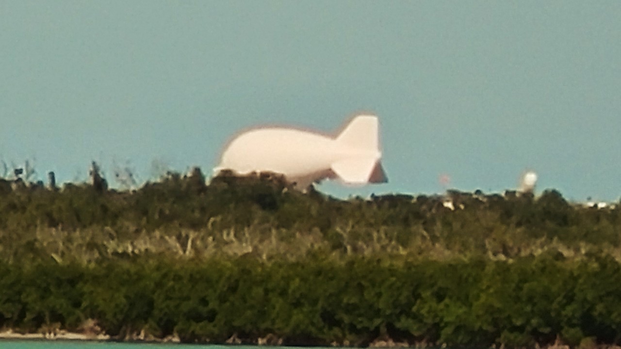
This part of the bike path was excellent, quiet, and picturesque, and at the end of Summerland Key, it crossed over onto a dedicated bridge to Cudjoe Key, where it then crossed back to another excellent section of SR 4A. At the western end of Cudjoe Key one could see the blimp, “Fat Albert”, still tethered off to the north. “Fat Albert” was supposed to be ending its 33-year flight history recently but appears to still be stationed there by popular demand. The blimp is a Tethered Aerostat Radar System, (TARS, in military-speak), and was part of an Air Force’s Drug-interdiction program that monitored the Mexico/U.S. border as well as the Florida Straits. The various “Fat Alberts” have been the subject of many stories in the Florida Keys, including numerous crashes in 1989, 1993 and 1994, and breaking free of its tether, drifting over the Everglades, and crashing there, as well. However, the most incredulous story was in 1991 when the blimp broke free and a fisherman connected the loose end of the tether to his fishing boat thinking he would tow it back to shore. Instead, he and his mates were taken airborne and dumped into water uninjured near Mud Key. Only when an Air Force F-4 Fighter shot down the blimp with an air-to-air missile did the boat settle back to the water’s surface, little worse-for-wear, leaving the boat’s captain happy to have gotten it back in one-piece.
The TARS Fat Albert Blimp on Cudjoe Key
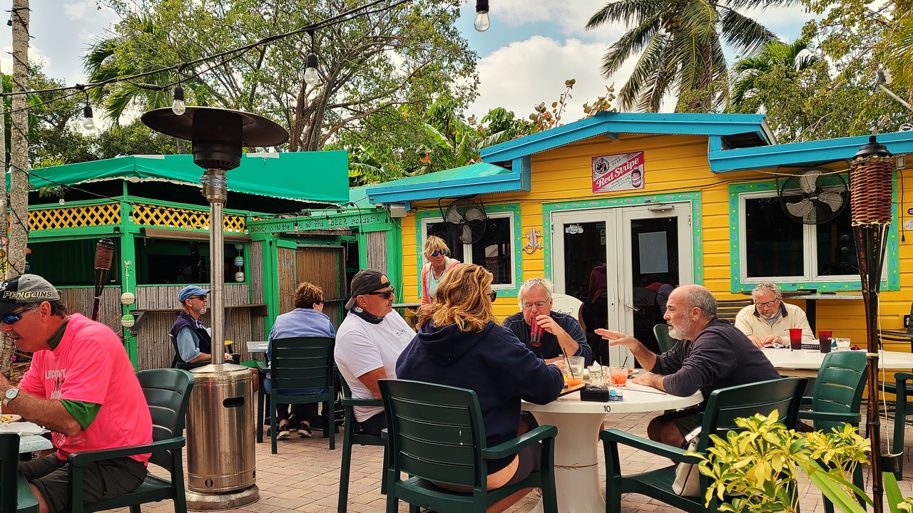
West of Cudjoe Key, a dedicated bridge takes us onto Sugarloaf Key and along to Mile Marker 20 where we stopped for lunch at Mangrove Mama’s – a quaint and kitschy mom-and-pop restaurant with an outdoor patio. After lunch, we began the 15-mile ride back to the car, but this time with a tailwind making the ride much shorter. When we got back to the cars, we loaded up the bike and made the drive to our hotel in Key West – The Hilton Garden Inn (Mile Marker 4) – located at the east end of Key West island, 4-miles from downtown. After checking-in, we caught the hotel shuttle downtown to the front of the Waterfront Brewery and explored downtown and parts of Duval Street. The day’s 36-mile bike ride and the enduring wind chill was rapidly wearing us down, so we ducked onto a restaurant patio with heaters where we had a meal of shrimp and conch fritters and salads. After eating, we strolled through the shops before returning to the hotel for a well-deserved night’s rest.
Lunch at Mangrove Mama’sWelcome to Key West SignThe Old Key West Custom House
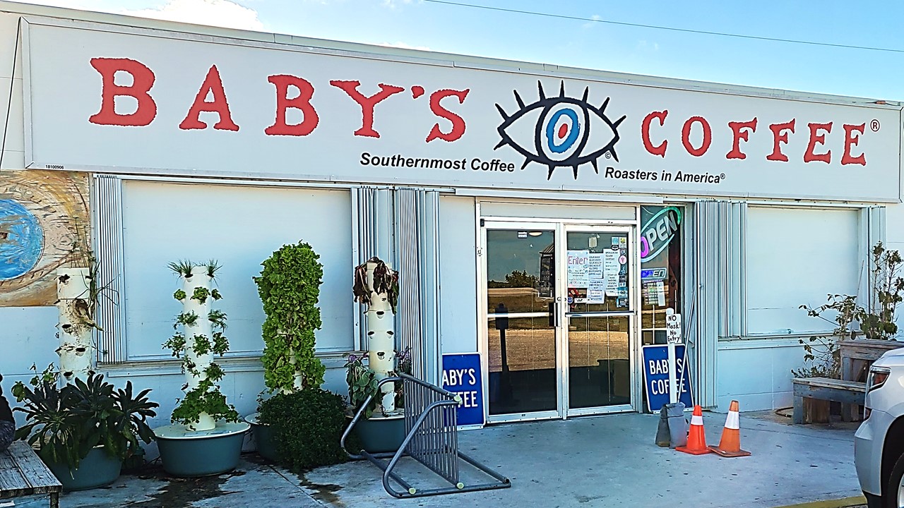
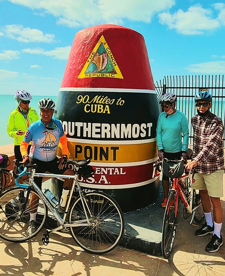
Wednesday morning, we rose early and set off east from the hotel on our bikes onto the most completed section of the Florida Keys Overseas Heritage Trail. The weather was beautiful and along the way we were “buzzed” by military jets doing “touch-and-go’s” at the adjacent Naval base (Boca Chita Field), and passed many people out for a jog, waiting for the bus, or riding their bikes to work. We rode to Sugarloaf Key at Mile Marker 15 where “Baby’s Coffee Shop” is located. This was obviously an immensely popular spot with commuters, and the “socially distanced” ordering line filled the small store. After getting coffee and bagel meals, we ate outside on picnic tables before beginning our journey back. When we arrived back in Key West, we continued riding our bikes along the southern route around the island next to Roosevelt Boulevard (A1A) and continued along the seawall and historic streets until we came to The Southernmost Point in the United States, which is marked by a large red buoy. Here we joined a short queue to get our pictures taken, and then rode the rest of the way around the northern side of the island until we arrived back at the hotel. We cleaned-up from the day’s 30-mile bike ride and caught the hotel shuttle downtown where we walked the waterfront marinas and shops, stopped for drinks and appetizers, and explored the busy Mallory Square tourists’ area. That evening, after returning to the hotel by shuttle, we drove to the store for next-day supplies and to pick-up sandwiches for dinner before returning to the hotel bar for drinks and a few games of cards. Today ended of trip’s bicycling part with a total of over 180 miles over 5-days, covering most of the Florida Keys Heritage Trail by bicycle, traveling both north and south!
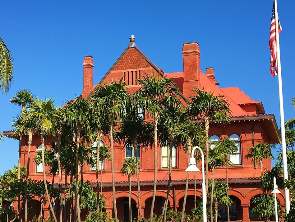
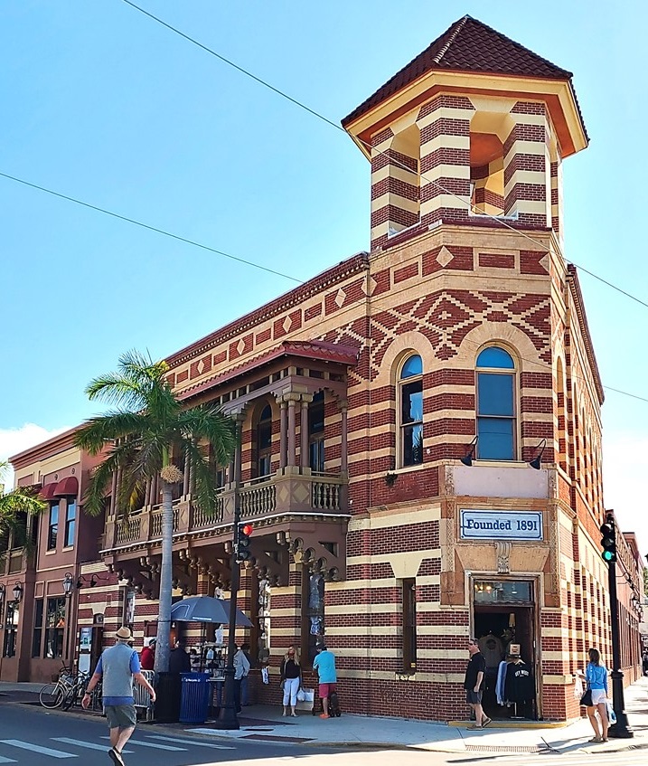
Breakfast at Babys CoffeeThe Southernmost Point in the United StatesHarry Trumans Little White HouseFormer First National Bank Building in Key West
Monday morning, we returned to “The Midway Café” for breakfast which was much busier with local workmen who frequent the place. After breakfast, we gathered our belongings and checked out of our rooms and drove south to a parking area, (Mile Marker 50), located beside the biking path. Although the spaces were full, we parked on the grass (with the permission of a local police officer) and began cycling south into Marathon. We had planned to ride to Pigeon Key via a refurbished part of the old Flagler Bridge but were informed that that part was still under construction and was not yet open. We started off anyways and had only covered ~1.5 miles when black clouds arose, and a huge rainstorm appeared on the southern horizon heading straight for us. We ducked for cover at a nearby service station and waited for the worst to blow by, and then cycled back to the cars in a light rain. We decided to instead, drive south and explore, while waiting for the weather to improve.
Middle Keys Map
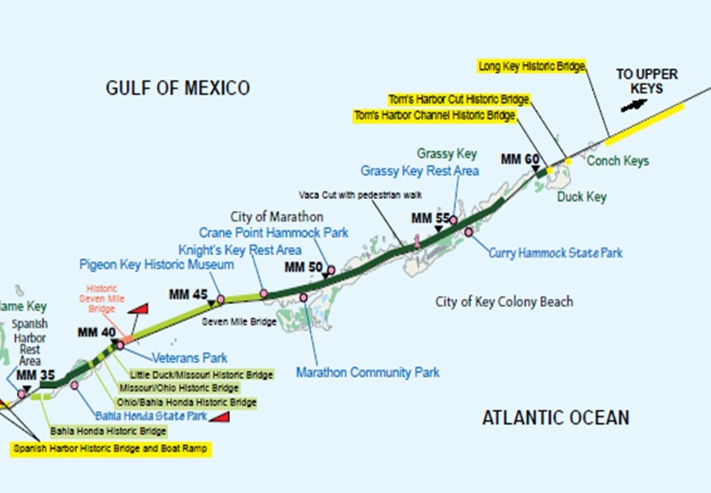
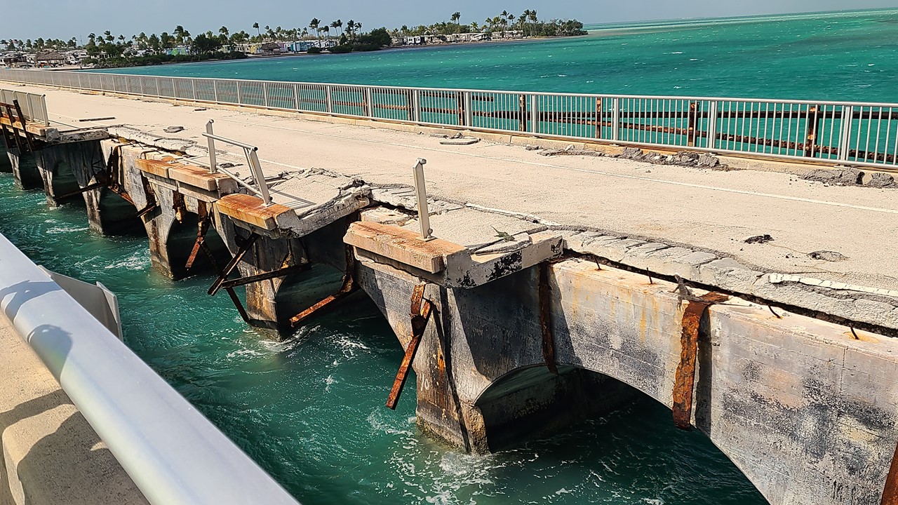
At the southern end of Marathon Key, (mile marker 47), is the famous “Seven Mile Bridge”. This was originally a railroad bridge and part of Flagler’s Florida East Coast Railroad (FEC) to Key West. However, when the railroad bridge was damaged by the Labor Day Hurricane of 1935, (200 mph winds and the lowest barometric pressure ever recorded in the Western Hemisphere), the line was sold to the United States Government, which then refurbished the Seven Mile Bridge, along with many other railroad bridges, for automobile use. In 1935 the bridge was widened for two-way traffic with a swing span to allow passage of boats in the Moser Channel of the Intracoastal Waterway. The swing span was located just south of where the bridge crosses Pigeon Key, a small island in the middle of the span that was used as a work camp for Flagler’s railroad construction crews. Then, in 1960, Hurricane Donna caused further damage and necessitating a more permanent solution. The current road bridge east of the historic bridge was constructed from 1978 to 1982. Today, much of the original bridge still exists, although the swing span has been removed. The 2.2-mile section to Pigeon Key, used as a fishing pier and long open to motorized vehicles to give access to the key, was closed to motorized traffic in 2008 after the unsupported sections began to sag. In 2014, the Florida Department of Transportation approved a $77 million plan to restore the old bridge. By 2017 the pedestrian section was closed, with extensive repairs predicted to be finished by about late 2021.
The Seven Mile Bridge
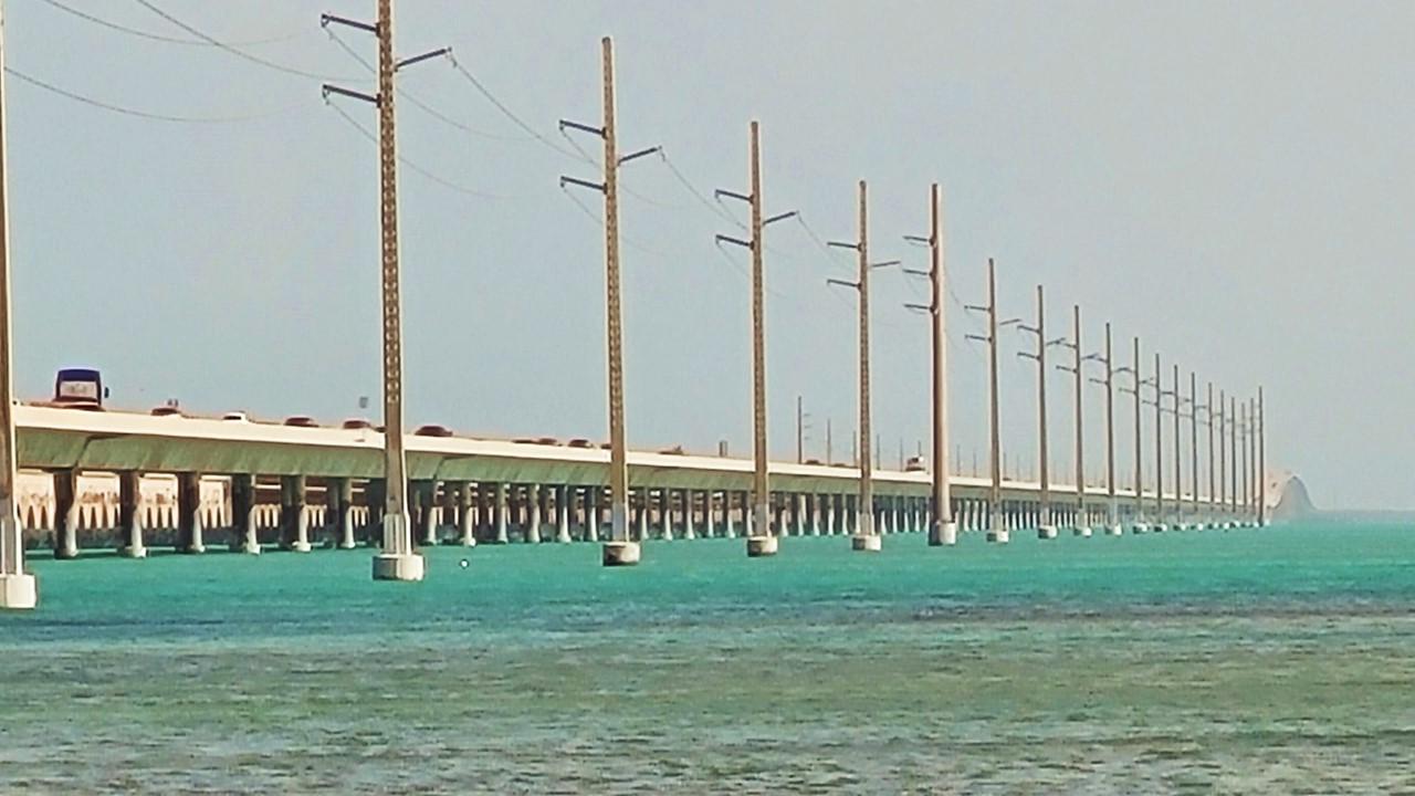
South of the Seven Mile Bridge is a series of small keys, (Little Duck, Missouri, and Ohio Keys), all connected by short bridges and accompanied by fishing/biking bridges located immediately east of U.S. 1, although not all of them are currently open. To the east of U.S. 1, connecting Bahia Honda Key to the Spanish Harbor Keys is the historic Bahia Honda Railroad Bridge also built by Henry Flagler as part of the FEC’s Overseas Railroad. In 1904 Flagler started what everybody considered a folly: the extension of the FEC Railroad to Key West which would later be known as the Overseas Railroad. At the time of its completion, it was considered the eighth wonder of the world, and was the most daring infrastructure ever built exclusively with private funds. The first train arrived in Key West on January 21, 1912 with Flagler arriving himself the next day. Flagler died soon after, and the railroad required significant maintenance due to storms and corrosion. Again, the Labor Day Hurricane of 1935 destroyed much of the line, and FEC sought abandonment of the project. Instead, the parts south of Dade County were purchased by the State of Florida and converted for highway use in 1938. However, the Bahia Honda channel was the deepest (28 ft) and instead of using concrete arches that supported all the other bridges, it was built with steel trusses high above the wave peaks. Since these railroad trusses were too narrow for two-lane automobile traffic, rather than rebuilding the bridge, the State redecked the top of the structure for use as the Overseas Highway. It must have been a harrowing automobile crossing high in the air atop those rusting steel trusses from 1940-1970! Thankfully, a new four-lane bridge was later built and opened in 1972, a few hundred yards northwest of the old bridge replacing the former route of U.S. 1. Two of the original truss spans were then removed – one near the east end to allow boat traffic to pass through Bahia Honda Channel without the danger of falling debris from the old bridge and the other at the westernmost end to prevent pedestrians from accessing unsafe parts of the bridge. It is a misconception that the trusses were removed to facilitate traffic for boats needing higher vertical clearance, as the new bridge has roughly the same vertical clearance of about 20 feet as the old bridge had. Today, the original bridge has fallen into a serious state of disrepair, (signs are posted on the bridge warning boat traffic to watch for falling debris), but all the sections have remained standing (not counting the two that were removed). The easternmost section has remained open to pedestrian traffic and is maintained by Bahia Honda State Park and provides a scenic overview of the area.
The old Flagler Railroad Trestle past Honda Bahia KeyThe Flagler Railroad Trestle converted on top for Autos
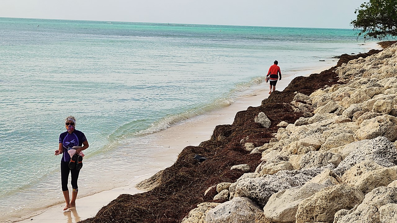
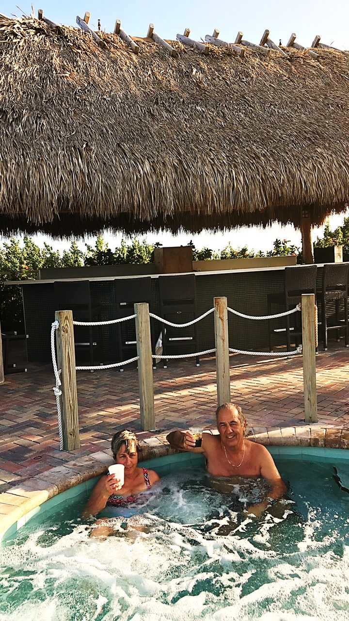
We continued driving to Mile Marker 30 on Big Pine Key where we turned the car around and returned to Bahia Honda State Park (Mile Marker 36). Here we visited the gift shop, explored the beaches, and examined corals and sponges that had washed up, and then unloaded our bikes to begin a ride out of the park north to the northeastern tip of Little Duck Key, (Mile Marker 40 – the southwestern end of the Seven Mile Bridge). After returning and biking every part of Bahia Honda State Park, we loaded up and returned to Marathon where we stopped at a bayside restaurant called “Porky’s” for lobster tacos, wine, and beer. By now, the wind had grown to 30 mph gusts, so we drove to a beautiful oceanfront public beach at “Sombrero Beach” where we walked through the water and collected shells, glass, and coral. Then we drove back to U.S. 1 for a little quick shopping before checking into our Hampton Inn Hotel at Mile Marker 53 on Marathon Key. The hotel had a small deck overlooking the ocean, a tiki bar and hot tub – which we took advantage of to sooth the “wind burn” of the blustery day, even though we only rode 16 miles. That night, we ordered pizza delivered and played several rounds of cards before calling it a night.
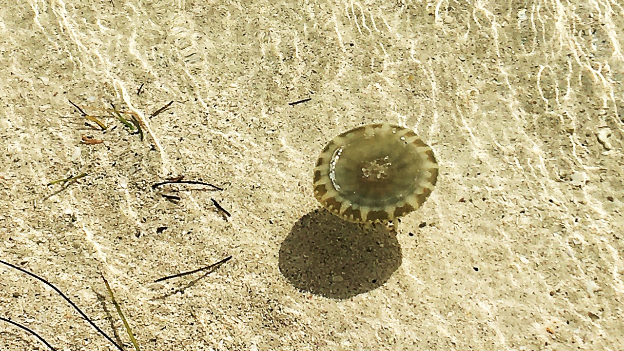
On the Beach at Bahia Honda State ParkJellyfish at Bahia Honda State ParkBiking the dedicated Biking BridgeThe old US 1 Highway BridgeWaterfowl in the LagoonsWall Mural at Sombrero Beach.Hotel Signpost in MarathonPam & Rocky in Hot Tub at Hamption Inn
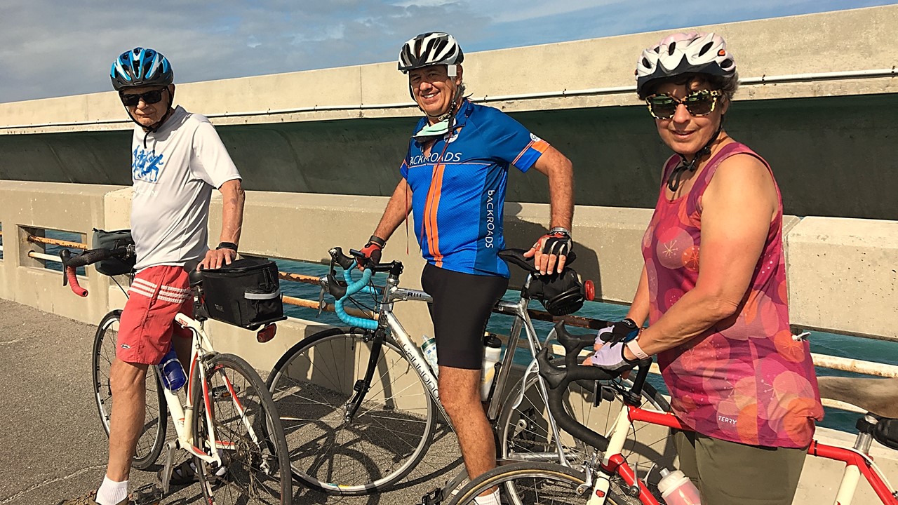
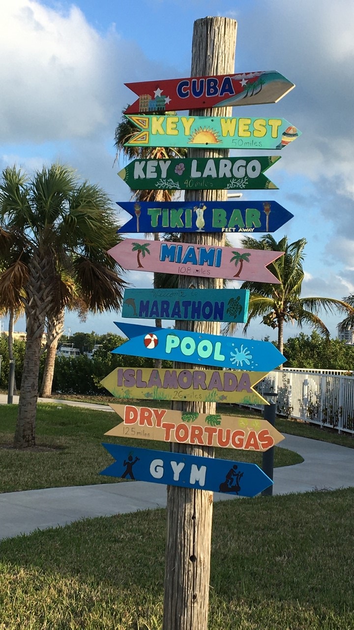
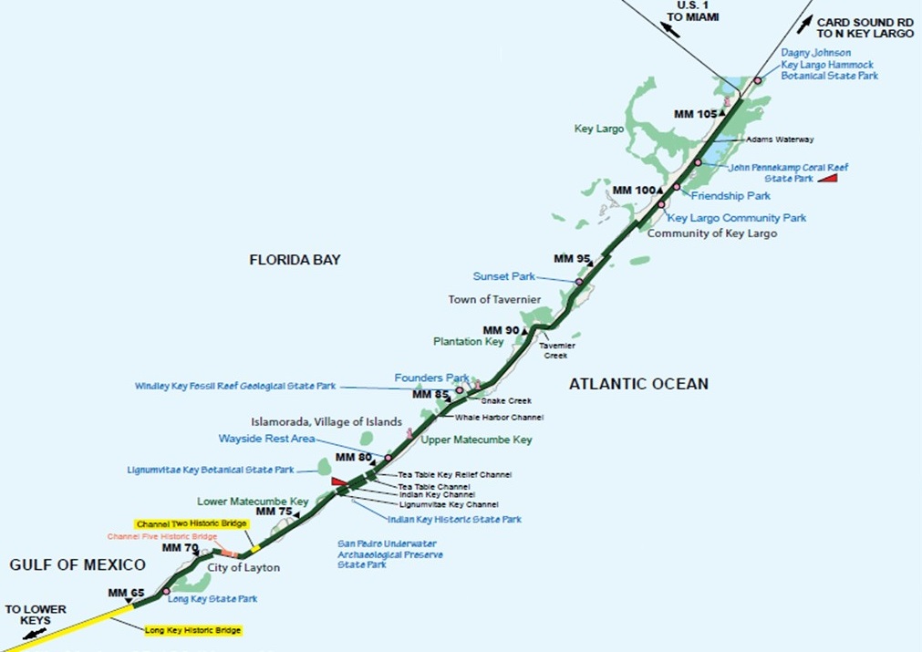
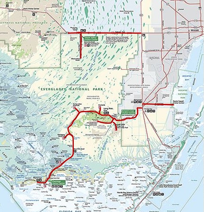
2020-2021 were “years of the pandemic” and with all international travel cancelled and domestic tour groups deemed “unsafe” for “Social Distancing”, we began to consider exploring places closer to home and in a more personal way. When the 2020 Great Ohio Bicycle Adventure was cancelled in April of 2020, we became serious about planning a “self-sagging” bicycling trip to explore the Florida Keys. Rocky had not visited the Keys for over 45 years and Julie had only been to Key West once. We decided to get hotel rooms at strategic locations along the route for evening overnights, and to use the intervening days to explore the areas north and south of our hotels by bicycle. Much of route is part of the Florida Keys Overseas Heritage Trail (FKOHT) and features more than 90 linear miles of existing trail paved in segments along a planned 106-mile corridor from Key Largo (mile marker 107) to Key West (mile marker 0) with no fees. The Heritage Trail is a mix of “Old US 1” Highway road and bridges, old paved and restored railroad bridges, paved utility service trails and road-side bike paths. The FKOHT is a multi-use bicycle and pedestrian resource that serves as a recreational and alternative transportation corridor for the Florida Keys. It parallels U.S. Highway 1, which is designated as a National Scenic Highway and All-American Road and will eventually incorporate 23 of the historic Flagler Railroad bridges, although only about half of them are currently accessible to the public.
Upper Keys Mao
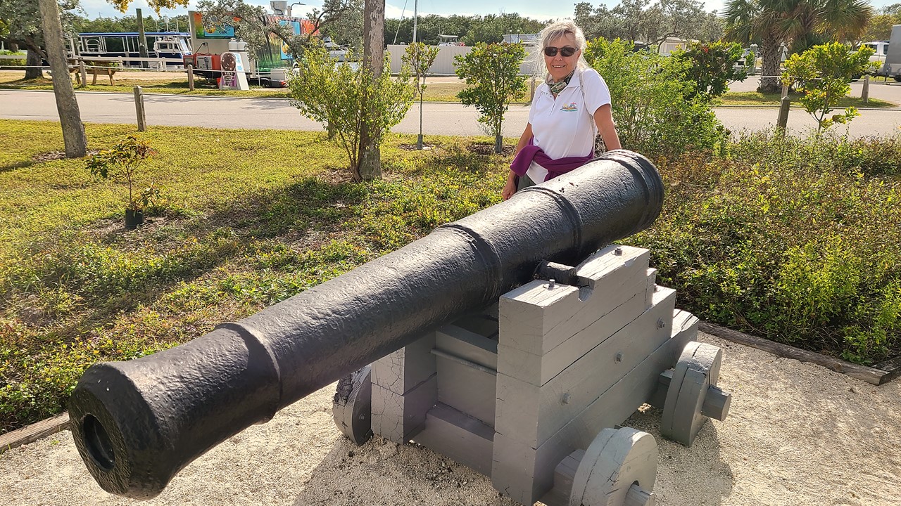
Since we live over 5-hours away from Key Largo, we planned the trip to take 8-days with travel. At the last minute, my wife’s cycle-enthusiastic sister and brother-in-law from Ohio decided to drive down and join us on the adventure. We left our house with two cars and 4 bicycles on Friday and made the drive to Key Largo where we visited the Key Largo Visitor’s Center, had a taco & nacho lunch on the dock at “Jimmy Johnson’s Big Chill Restaurant”, and then entered and explored John Pennekamp Coral Reef State Park, the first undersea park in the country. The weather was too chilly and windy for us to enter the water that day, but we explored the many beaches and hiking & nature trails by foot before leaving to check into our hotel, the nearby Hampton Inn, (mile marker 102), with its own bayside beach, and pool. That night we took a quick swim before walking to Alfredo’s Restaurant for a shrimp meal and then relaxing with wine and a lively game of cards back at the hotel.
Welcome to the Florida KeysCannon at John Pennekamp State Park
Saturday morning, we had breakfast at the hotel at 7:30am, checked-out, and then boarded our bicycles to explore the Heritage Trail traveling south. The trail here was a paved path off from the road that took us over three restored bridges dedicated to fishing, pedestrians, and bicycles. The trail then moved slightly east on to “old US 1” in Tavemier, where a series of ocean-side estates with peacocks and private ocean access dominated. It was clear that this area had suffered previous hurricane damage as entire tracks of former housing complexes were now large vacant lots. While cycling, our next night’s hotel, “The Sands of Islamorada” (located at mile marker 80), called to inquire about our “check-in”, and since by then we were already on Upper Matecumbe Key and only 2-miles away, we rode to there and completed the required paperwork. We then turned around and began the ride back and soon passed again the Hurricane Memorial at mile marker 81.5. The Hurricane Monument on Islamorada relates the experience of the devastating 1935 Labor Day storm and serves as the burial place for the ashes of many of those who died.
Biking the Heritage TrailThe Memorial in Islamorada to 400 lives Lost in 1935
Islamorada was reached by the Flagler’s Florida East Coast Railway in 1907 and served as the headquarters area for the over 600 World War I veterans that were sent to Lower Matecumbe camps in 1934 to work on building the automotive bridges that would connect the islands as the Overseas Highway. The island had been originally settled by the Russell Family in 1850 who grew pineapples, melons and tomatoes for transporting north. In the 1870’s, the Pinder Family took a land grant in the center of the island. When Henry Flagler’s Chief Railway Engineer, William J. Krome, reached the island, he built a home there, but needed to give the town a name to justify having a Railway Station and chose “Island Home” after Pinder’s boat. The island’s produce industry flourished until the railway was completed to Key West in 1912 and inexpensive pineapples and limes began being transported in railway cars from Cuba via ship to Key West where they we taken up the East Coast. After that, Islamorada’s industry focused on tourism and fishing.
Channel view from Biking Bridge
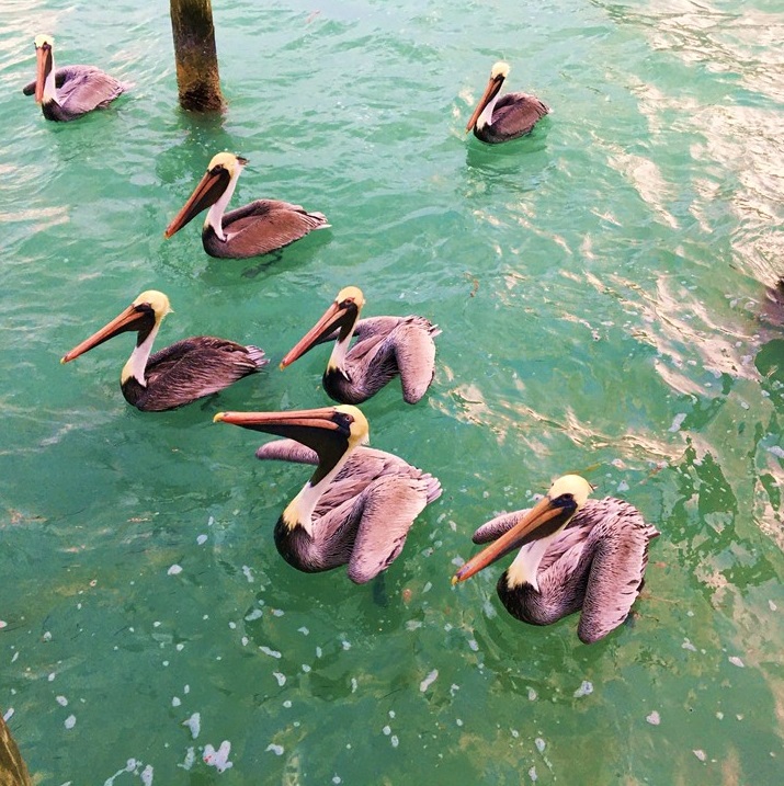
We continue back to mile marker 82 to eat lunch at the “Lorelei Restaurant” where we sat bayside on the dock watching 3-5 ft tarpon cruising by, and people-watching customers arriving by car, boat and even seaplane! We then biked back to our cars still at the hotel at mile-marker 102, before loading-up and driving south to our Islamorada hotel. However, Saturday night traffic on U.S. 1 in the keys was very heavy, and the drive took over an hour before we reached our destination. “The Sands of Islamorada” is a completely remodeled and modernized version of a 9-room “mom-and-pop beach motel” located ocean-side in Islamorada. The owners live on-site and only staff the office for limited hours, but they were attentive and accommodating, and their pool with dual hot tubs were accented by their 8-McCaw enclosure and local 3-ft long iguanas. After showers and settling, we all walked 3-blocks south to “The Lazy Days Restaurant” – a “hopping” place where we luckily got the only remaining table outside during “happy hour”. Here we enjoyed drinks, calamari, conch fritters and a large brie cheese-platter covered with lingonberries. At their nearby dock, one could feed the gathering tarpon or get up-close to the resting pelicans. After dinner, we relaxed in the hotel’s hot tub and recounted our first day’s 44-mile ride.
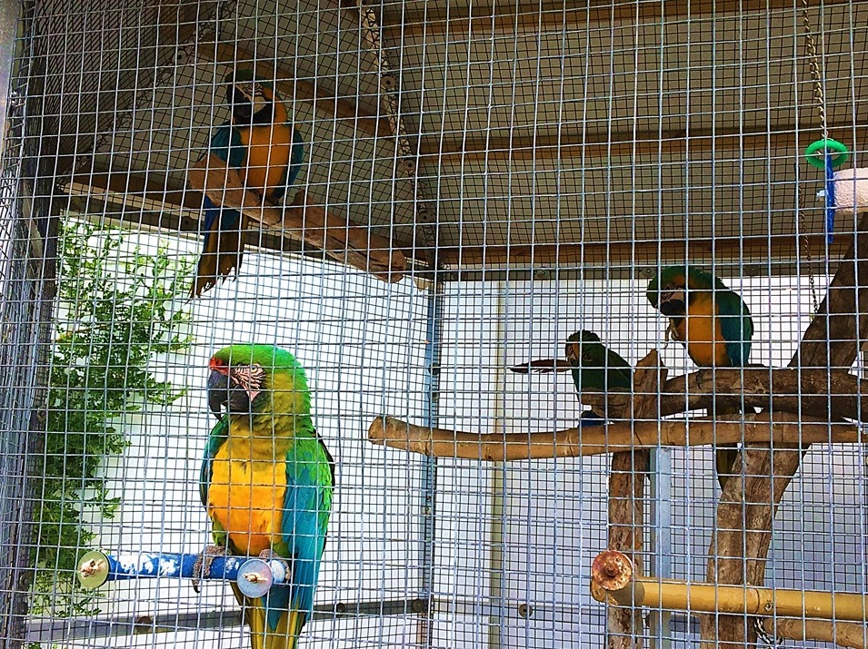
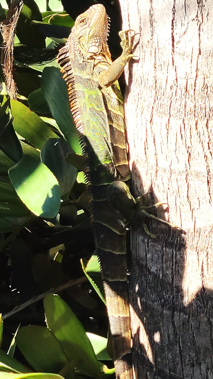
Lunch at Lorelei RestaurantMcCaws at Sands of Islamorada InnLocal Iguana Climbing TreePelicans Resting after Hunting Fish
On Sunday, our plan included eating breakfast at the “Midway Café” located just ¼-mile north of the hotel on U.S. 1, and then bicycling south. After a large breakfast outside among the many locals that eat there, we assembled at the hotel and set off south and, after a series of small bridges, the trail exited once again onto old U.S. 1, this time on the west side of the road, and again served as the access road for the local estates along the bays of the Gulf of Mexico side. Since it was Sunday morning, the trails and paths were full of “morning walkers” enjoying the weather, getting exercise, and walking their dogs. After crossing a high-rise bridge, we arrived at the town of “Layton” where we took a quick break. From there, the bike trail got very bumpy and was in serious disrepair for a way before we reached Long Key and the Long Key State Park entrance. South of that, at mile marker 71, the bike path entered the ocean-side Long Key Pedestrian Bridge – the second-longest bridge of Henry Flagler’s railroad. Along the bridge there are twenty cantilevered fishing platforms, (“bump-outs”), added to each side to provide space for both fishing and bicycles. Although this part of the route demands riding slow to avoid pedestrians, it was enjoyable watching all the families fishing and having a fun day on the bridge. We continued south along the path on mostly excellent bridges and paths past Conch Key, Little Duck Key and Grassy Key into Marathon Key, including where the path went west into the mangroves following the Utility service path. Along the way, we stopped to check-out different restaurant menus before turning around at mile marker 53, and then stopping for lunch at “The Island Fish Company” located bayside at mile marker 54. The restaurant had a special Sunday lunch menu that included shrimp tacos and margaritas. It was not crowded, and we sat on the dock overlooking the water and enjoying the sun. On the way back, we retraced our path except for the “bumpy” section which we avoided. We stopped for drinks and a bathroom break at a convenience store in Layton and explored Anne’s Beach along a lovely boardwalk at Mile Marker 73, and then road back to the hotel using the bike paths. All together, we cycled over 54 miles, and at the hotel, we met some northern visitors and enjoyed the hot tub. That night, we returned to “The Lazy Days” for Happy-Hour drinks and eats before returning to the hotel room for wine and another game of cards.
Bicycling & Exploring Florida’s Everglades National Park
The year 2020 was one where the international travel limitations imposed by the Covid-19 Pandemic refocused our adventurous glances to domestic locations that we had not yet explored. Only hours away from our Florida home is the Everglades National Park – a place that neither of us had visited or ventured into previously. And so, after a bit of hurried planning, we decided to load our bicycles and head for the Park’s Eastern Entrances to learn what we could and to explore this national wonder.
Everglades Trip Locations Map
The Park’s history extends back to the 1800’s and early 1900’s when the only human residents of the region were local Native Tribes. The early European settlers viewed the region as a wasteland full of mosquitoes and useless for development. Most of the area is characterized by an immense, flat, limestone plateau with less than a few feet elevation variation, populated by extensive grasses, sparse hammocks of trees and bushes, and covered by ~1-4 feet of water. The water is really a 100-mile wide river that slowly flows south into Florida Bay, providing the habitat for various species of birds, reptiles, fish and amphibians, and providing the source of fresh water for both the recharging of Florida’s aquifers and for Florida Bay. As Florida’s population grew and development capabilities progressed, the water supply to the Everglades was diverted via irrigation and canals to the ocean to create more farmable land. In 1945, the problem had gotten so bad that the dry, central Everglades’ grasses caught fire and destroyed a large part of the ecosystem. In response, the Everglades National Park was created in 1947, and since then, a comprehensive restoration project has been underway to restore the historic natural flow of water to the region, and to remove non-native and invasive species. Today, it is encouraging to see the return of nesting birds and wildlife to the region.
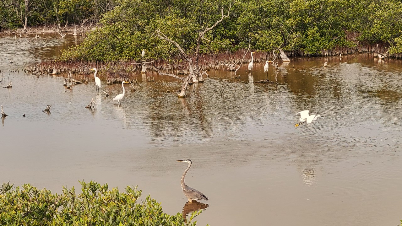
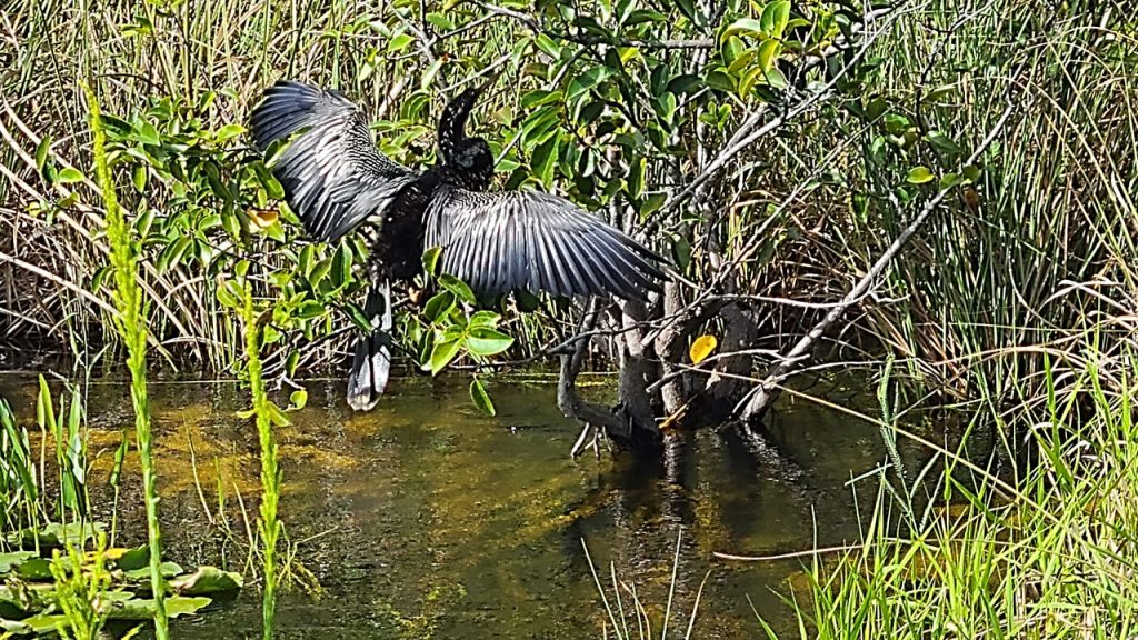
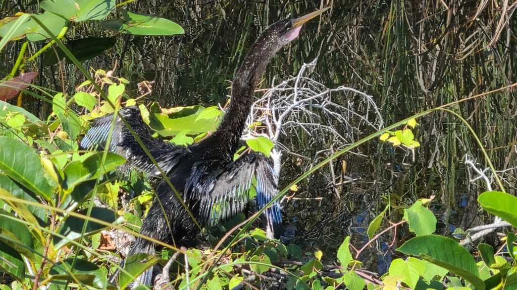
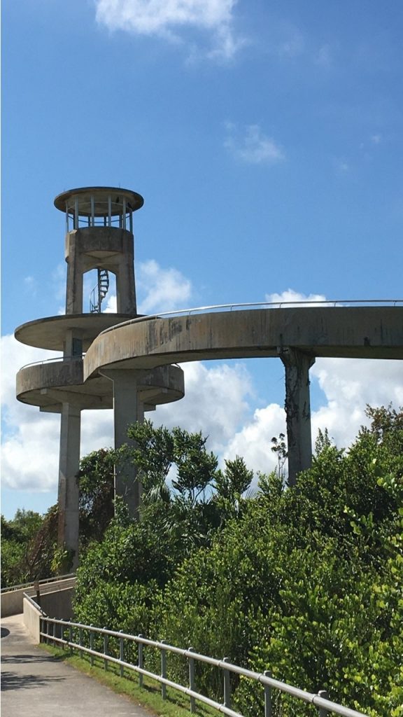
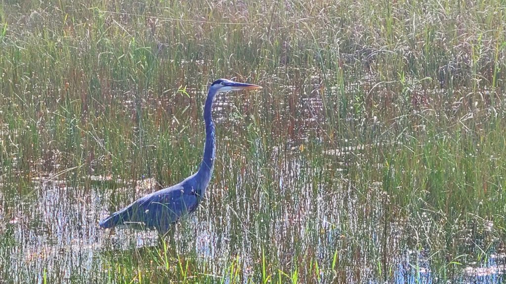
Sunday morning, we rose early and headed in the car to the Park’s most northeastern entrance at “Shark Valley”. Shark Valley is actually a long, wide, shallow valley, only a few feet deep, that extends from northeast to southwest across the Park, and that empties into Florida Bay. The Shark Valley Visitor’s Center is located 30 miles west of the Florida Turnpike, and we parked and unloaded our bicycles when we arrived. Here is located a 15-mile-long loop on paved road through the “fresh-water prairie”, with an observation tower at halfway point. The route is shared by a tour-tram that circles the same loop every hour. As we rode, we observed birds (cormorants, ibis, anhingas and blue herons), turtles and a few small snakes, but no alligators. At the Tower, we climbed to the Observation Deck to look out over a vast vista of sawgrasses as far as the eye could see. The ride was hot and steamy in the mid-day Florida sun, and at the end we visited the Visitor’s Center there for a cold drink and to learn more about the area’s history. After inspecting the area’s other trails the (Bobcat Boardwalk and the Otter Cave Hammock Trail – which was under water), we headed east out of the park through the water Control District to a local Pit Bar-B-Q outdoor place where a cold beer and local pulled pork made for an excellent lunch.
Biking the EvergladesAnhinga Drying his WingsAnhinga Upset with UsObservation Tower at Shark ValleyBlue Heron Looking for a Meal
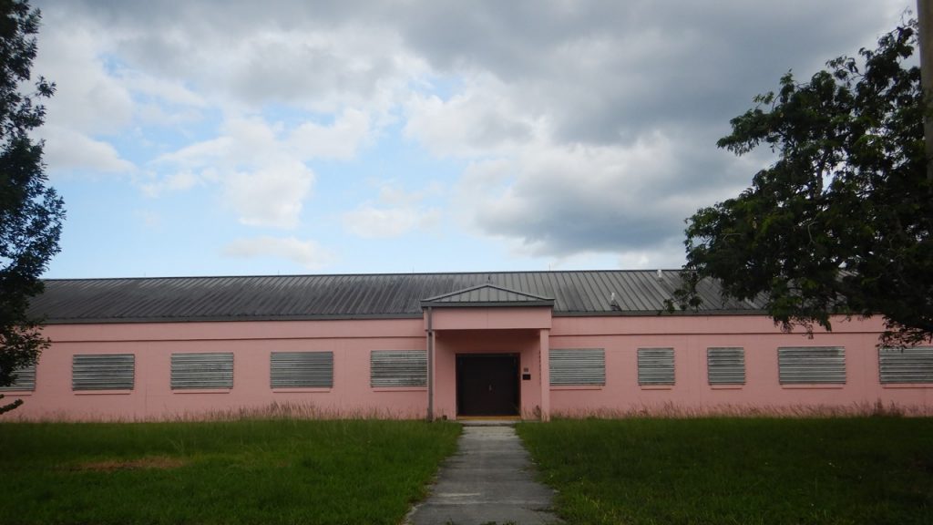
After lunch, we headed south to the Park’s most southeast entrance at the Ernest E. Coe Visitor’s Center located 11 miles from Homestead – an area that was devastated during Category-5 Hurricane Andrew in 1992. The Visitor’s Center has a gift shop and excellent displays, but its Parking Lot is under renovation getting ready for the “winter rush” of visitors and the hourly free tram that they run from there to The Royal Palm Visitor Center located ~8 miles away. After our visit, we headed towards the Royal Palm Center and were intrigued by a sign to the “Nike Missile Center”! We headed down an old, small paved road past denuded limestone covered with ~1-foot of water with a mound of dirt in the distance. Apparently, the area had been used for growing the non-native Brazilian Pepper Plant which has been nearly impossible to eradicate. Therefore, they removed everything above the limestone and secluded it for some number of years in a last effort to eliminate it from the area. Someday, the thin soil layer will be returned to the carbonate plateau.
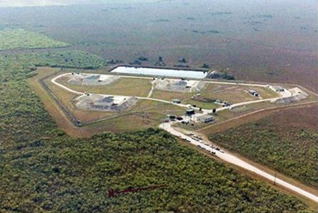
After traveling ~10-miles down this road and passing a South Florida Boy Scout Camp, we came upon a set of pink buildings that were locked up with a dozen Government vehicles parked outside. It turns out that these Administration Buildings were the entrance to the site of the HM69 Nike Hercules Missile Center that once housed nuclear warhead surface-to-air missiles. The warheads are gone, but the barns used to hide them are still there, as is a fully restored Nike Surface-to-Air Missile. Because of the shallow water table and limestone base, the idea of silos was replaced with 3 barns, including 4 bunkers of 6 missiles each, as well as dormitories and guard dog kennels – and, of course, many, many alligators! Although the site was closed the day we were there, it is opened for public viewing with a ranger in the late Fall and early winter. For more information, visit the site: https://www.nps.gov/ever/learn/historyculture/hm69.htm
Excerpts from their site:
HM69 Nike Missile Base – A Relic of The Cold War
Everglades National Park houses one of the best-preserved relics of the Cold War in Florida, a historic Nike Hercules missile site called “Alpha Battery” or “HM69”.
The site remains virtually the same as it was when official use of the site ended in 1979. Construction of the site by the U.S. Army Corps of Engineers was completed in 1965, just after the Cuban Missile Crisis of October 1962. At the time, the nation’s air defenses were positioned to protect against a possible Soviet air attack over the North Pole and thus, this and other anti-aircraft missile sites were established to protect against a possible air attack from the south. The Nike Hercules missile site was listed on the U.S. Department of the Interior Register of Historic Places on July 27, 2004 as a Historic District.
The area includes 3 missile barns, a missile assembly building, a guard dog kennel, barracks, 2 Nike Hercules missiles, and various support elements. HM69 was also significant because of the technology employed. The South Florida Nike Hercules sites were integrated with Hawk missile sites to provide an all altitude defensive capability around South Florida. Approximately 140 soldiers staffed the 3 above-ground missile barns of HM69 to protect against an air attack from Cuba. The personnel of HM69, along with the members of other South Florida unites, received the Army Meritorious Unit Commendation which was one of the few times that it was awarded for deterrence rather than engagement with the enemy.
Visitors may visit the site most days between early December and late March. There is an open house program, as well as Ranger-guided tours. Our visitor programs fluctuate due to seasonal changes and staffing capability. Please check with the Ernest F. Coe Visitor Center or view the park’s calendar for scheduled programs at the site.
Nike Missile Base Administration OfficesNike Missile Base from the Air
After sidetracking to explore the Nike Missile Site, we completed our journey to the Royal Palm Visitor’s Center to check out the trails there. The Center was closed, but we made note of the local trails that were located there in preparation for our return visit the next day. We then drove to scout out the area and trails at Long Pine Key. The Camping Area there was also closed, but the region looked to be a good place to explore by bicycle when we returned.
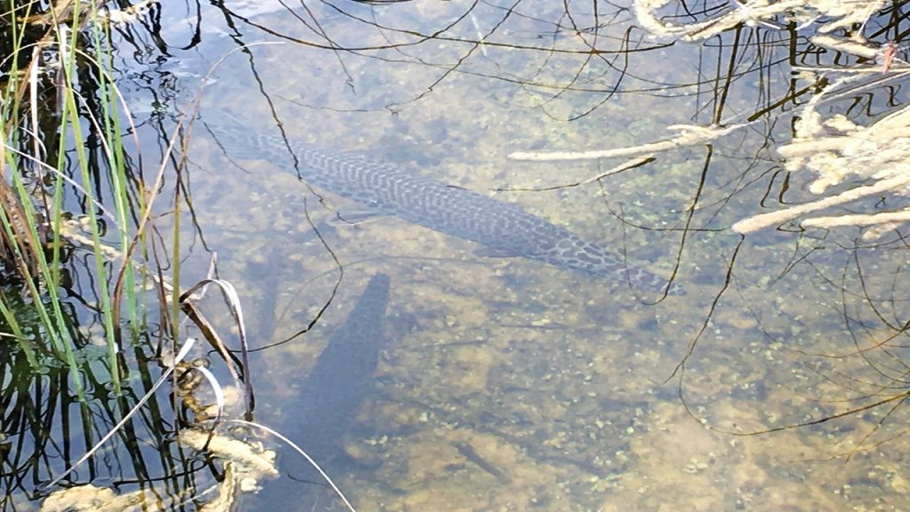
From there, we traveled west on the Main Park Road to a short boardwalk at Rock Reef Pass – one on the highest elevations in the Park – 3-4 feet above sea level! Here we could observe the ibis’ hunting in the grasses and the Florida Garfish swimming in the shallow water. Then, we traveled to the Pa-hay-okee Overlook which provided a boardwalk to a raised platform that overlooked the extensive freshwater Marl Prairie.
After that, we headed back east out of the park just in time to meet a storm that brought wind and heavy rain to our drive. We arrived at our hotel – the Hampton Inn in Homestead at about 5:30pm, where we enjoyed a hot shower, a lite dinner, and a bottle of red wine.
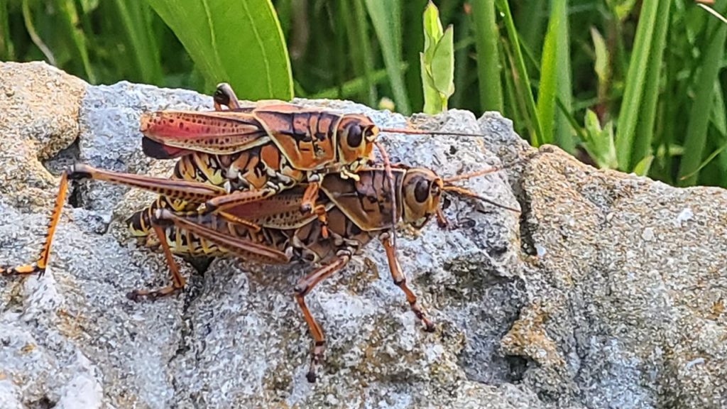
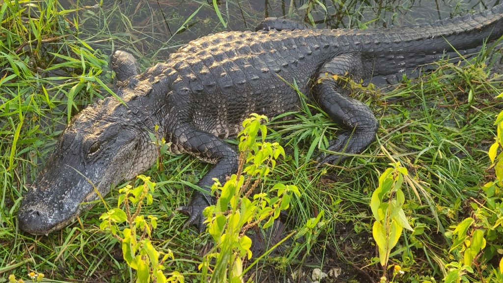
Monday morning, after an early hot breakfast, we headed back to the Royal Palm Visitor’s Center to watch the sun rise and look for wildlife. The Royal Palm Visitor’s Center was originally located among a grove of royal palm trees, but they were wiped out with Hurricane Andrew in 1992. We walked the Anhinga Trail – a wonderful boardwalk loop that winds out over the hammocks and sawgrass prairie. Immediately we came upon several enormous grasshoppers that were mating, and along the side of the trail we saw three different 5-7’ alligators resting warily. The sawgrass marsh was full of birds and small fish peacefully hunting as the sun rose over the horizon.
Giant Grasshoppers MatingEverglades Alligator
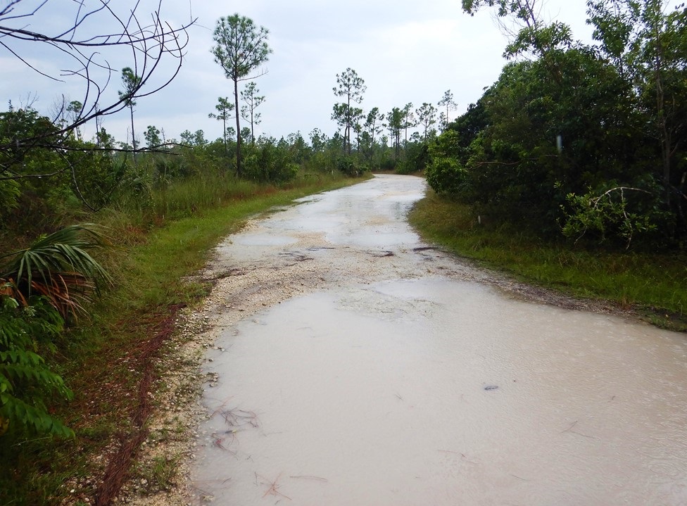
Next, we headed back to Long Pine Key – a two lane limestone track that winds through the pinewood forest for a few miles on some of the higher and dryer land. We unloaded our bicycles and entered at Gate #4 and rode for some distance, but it soon became apparent that the prior evening’s rains had flooded sections of the trail and that the mosquitos were in full attack mode. When the trail became almost impassable, we finally turned around and decided to look for other adventures. After returning to the car, we decided to explore the deserted campgrounds on bike, checking out the lake, the campsites and the new outdoor theater awaiting their eventual re-opening for campers. Then, after loading up our bikes, we drove to the boardwalk at Mahogany Hammock – an area that is still home to a giant Mahogany tree and a tangle of Strangler Fig trees and pairs of nesting owls.
Flooded Long Pine Key Trail
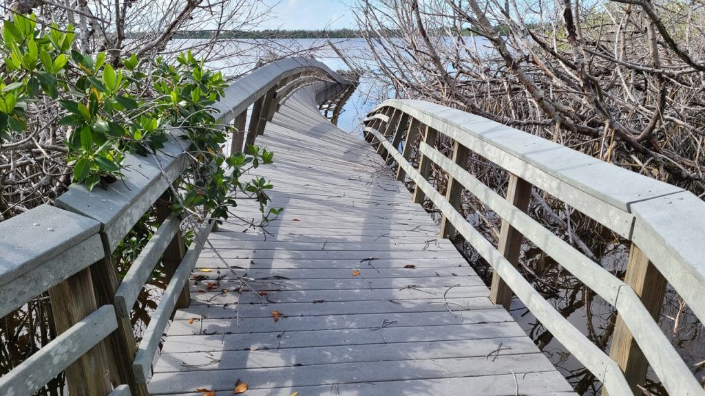
Our next stop was West Lake which was said to have a lovely looped boardwalk through the mangroves and out over the lake. The area was renown to be popular with boaters and picnickers, but we had yet to see another person all day. We set off one direction on the loop marveling at the boardwalk built through the nearly impenetrable mangrove forest and listening to the frogs and fish startled by our presence. However, just before reaching the lake, the boardwalk was closed, and we could see that it was heavily damaged up ahead. We circled back and took the other direction around the loop which went all the way out onto the lake before it was also closed, but it did provide an excellent view of the twisted, broken and contorted remains of the lake portion of the boardwalk. Apparently, Hurricane Irma in 2017 drove huge waves in the small lake that destroyed anything built over the open water.
Garfish in the Shallow WaterDamaged Boardwalk at West Lake
After West Lake, we continued southwest on the Main Park Road until we arrived at the entrance of the Snake Bight Trail which would take us to a scenic Florida Bay viewpoint. We parked on the roadside, unloaded our bikes and began to ride down the trail. However, it soon became apparent that this trail had not been maintained as we had to fight encroaching bushes, downed trees, and the ever-present mud and mosquitos. Apparently, this end of the park is only principally visited by campers, boaters and hikers in Florida’s winter months of December-February, and the Park does not dedicate many resources to it out-of-season. Therefore, we again decided that discretion was the better choice, turned around and went in search of other areas to explore. Along our journey traveling southwest, we had hoped to explore a paved road and trail to Bear Lake, but this lane was clearly so overgrown that we did not even attempt to enter it.
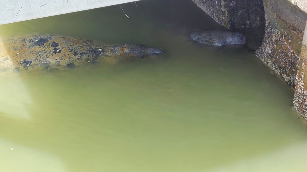
Finally, we reached the end of the Main Park Road at the Flamingo Visitor’s Center located on the shores of Florida Bay. This Visitor’s Center was also destroyed by Hurricane Irma in 2017 and it is currently being rebuilt and is scheduled to reopen in 2021. The construction workers were the first people we had seen all day. In the parking lot, we unloaded our bikes and rode the lovey Guy Bradley trail along Florida Bay’s shore until we reached the Eco-Center Campgrounds. Here there were mowed camping pads, an amphitheater, restrooms, and a series of Eco-Tents – all set-up and waiting for visitors – of which there were none! We rode back to the Visitor’s Center and checked out the adjacent marina and store where we stopped for a snack. The Marina was open and provides fuel, supplies, rentals, and boat tours to visitors. In one section of the marina were a half-dozen manatees snuggling up near a water runoff outlet and we watched them for awhile before biking back to the car, loading up, and beginning the trip back through the park.
Ibis at Florida BayManatees at Flamingo Marina
Upon exiting the park, it was still early afternoon, and we decided to head east 18-miles to Biscayne National Park, located on Florida’s East Coast between Key Biscayne and Key Largo. The Park encompasses a mainland mangrove shoreline, the shallow Biscayne Bay, the surrounding islands, living coral reefs and a large number of shipwrecks. It was established as a National Monument in 1968 and became a National Park in 1980. It was designated a park to protect both the terrestrial and undersea life in the region. The Park was open, but Hurricane Teddy located offshore had brought huge tides and waves to the region flooding most of the shoreline and boardwalks. We walked the fishing pier and explored the Park’s store before leaving for dinner carry-out from Chili’s, a hot shower and packing for our return trip home in the morning.
Map of Biscayne National ParkBiscayne Park Visitor’s Center
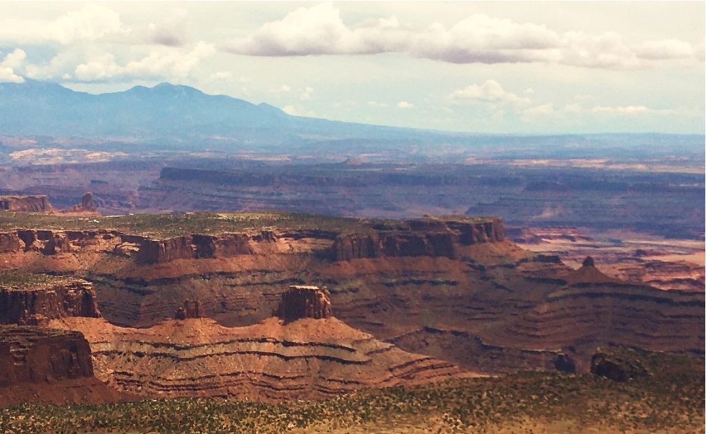
Exploring & Rafting Arches & Cataract Canyon in Utah
Part 5 – Dead Horse Point, Arches Delicate Arch & Colorado National Monument
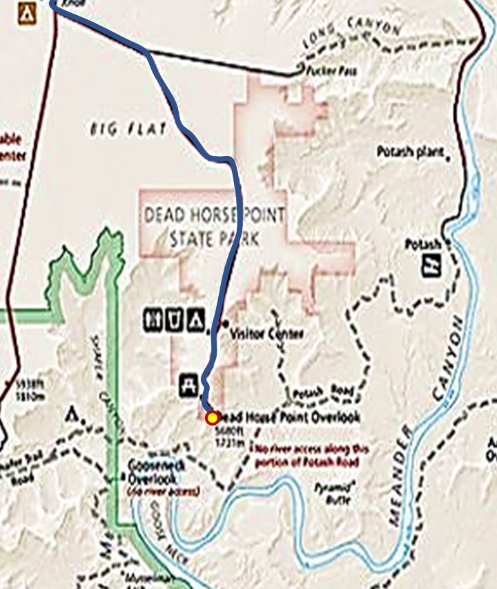
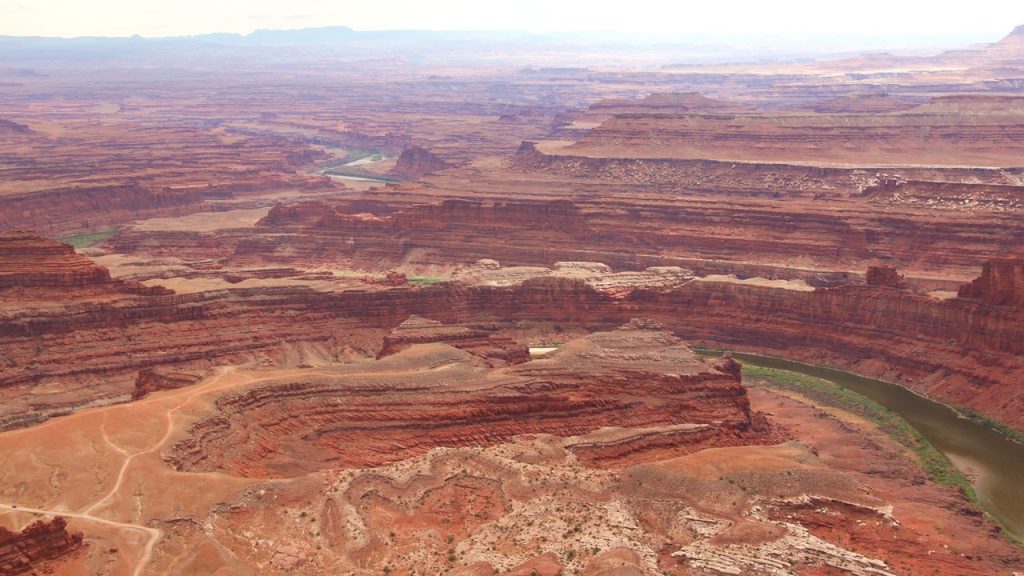
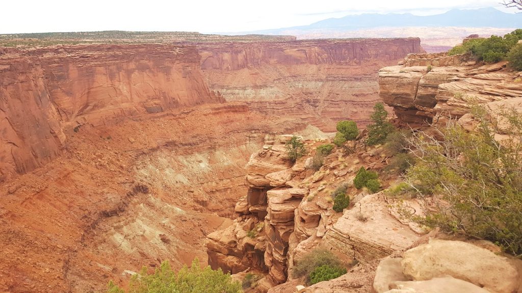
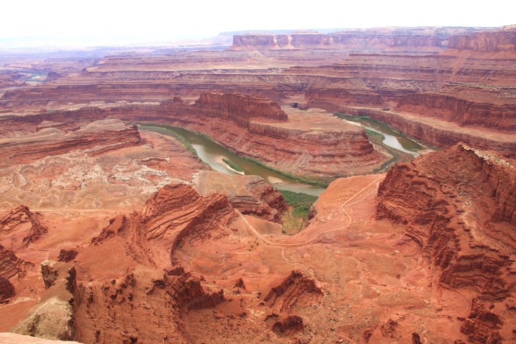
Dead Horse Point State Park
Since the rafting trip was ended and it was still early afternoon, we returned to the hotel to check-in and then immediately drove in the car to Dead Horse Point State Park. This park follows a narrow mesa that juts out and overlooks Canyonlands National Park with spectacular view and was recommended by the River Guides for us to visit. At this park, the Entrance Gate was open and there was a $20 charge to enter. Dead Horse Point is a small and narrow mesa connected by a very narrow “neck” where early cowboys would drive wild horses to capture and secure them. Apparently, one time, they left a large pen of horses trapped there, but with no way out and no water, they all died, thus giving the area its name. At the park’s “Point”, the trails follow the mesa’s edge and one can see amazing views of the Colorado Canyons. After exploring each of the easy trails and views, clouds began to roll-in, so we began the trip back. On the way out of the park, we noticed signs for “Yurts”! Not knowing what “yurts” are, we followed the signs and came upon a group of wooden platforms supporting large, round, pointy “tents” that are apparently for rent from the park. Most of them were occupied by families with off road bicycles, which the park supports with a large number of dedicated biking trails.
Dead Horse Point State Park Map
After returning to the hotel, we showered and went to the liquor store to buy a celebratory bottle of wine. However, it turned out that today was “Pioneer Day” – a State Holiday in Utah, and the store was closed. Then we went to dinner at our favorite eatery – The Brewery – and bought a bottle of wine with dinner from them. That night we packed and prepared for the next day’s adventures.
Colorado River from Dead Horse PointCataract Canyon from Dead Horse PointThe Loop from Dead Horse Point
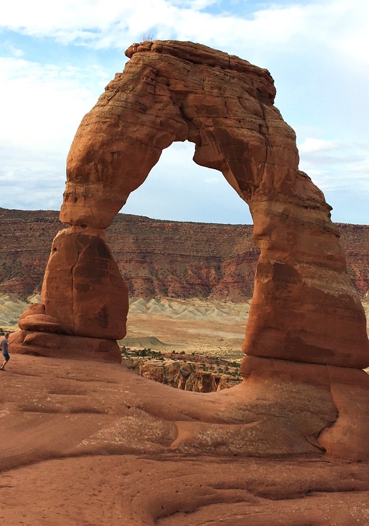
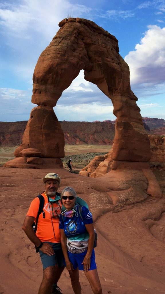
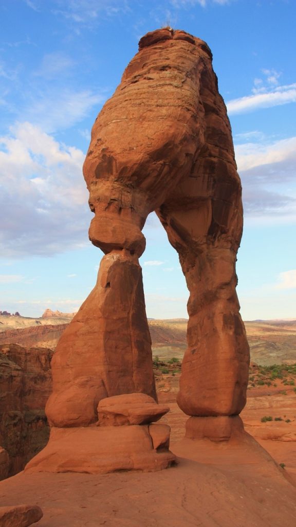
Arches Park’s Delicate Arch
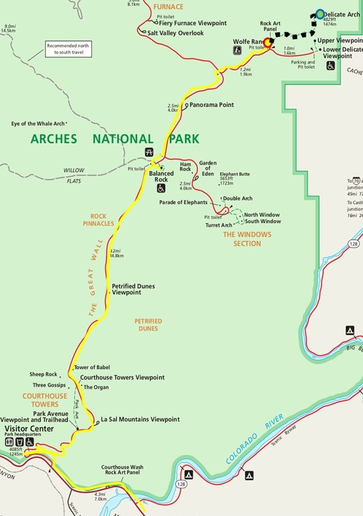
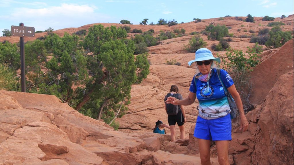
On Saturday we awoke early and immediately drove to Arches National Park and drove to the “Wolfe Ranch” trailhead to the famous and oft-photographed “Delicate Arch”. The moderate morning weather would make the 3-mile 2.5-hour hike more enjoyable.
Hike to Arches Delicate Arch Map
Upon arrival, there were only ~10 cars already there and the trail in front of us was vacant. The trail starts with a few ups and downs, but soon starts a steady ascent over slick rock petrified sand dunes with the trail marked by stone cairns and an occasional “trail” sign. The final part of the trail is a small ledge that circles a rock spire before coming into view of the arch located across a steep, circular depression. The backside of the arch is a very steep drop to the mesa floor, but the few people that are there are respectful taking turns taking their pose under the “Delicate Arch”. After taking our fill of pictures and relaxing to enjoy the view, we begin the hike back to the trailhead passing an increasing number of people making their trek to this landmark. Upon getting back to the parking lot by ~9:30am, the number of cars now number in the 100’s and we are glad we began early before the crowds came and the temperature rose. We return to the hotel for breakfast and showers before packing, loading up the Jeep and checking out to begin the uneventful drive back to Grand Junction.
Arches Delicate ArchSide view of Delicate ArchHike Down from Delicate Arch
In Grand Junction, we check into our hotel located only 1/2 -mile from the airport and unload our gear. This hotel is a throwback to hotels of the west from 30 years ago, but the rooms are huge and comfortable. Once we are settled, we decide to grab some lunch on the outdoor patio of a local “Buffalo Wild Wings”, which we have not visited in over a year.
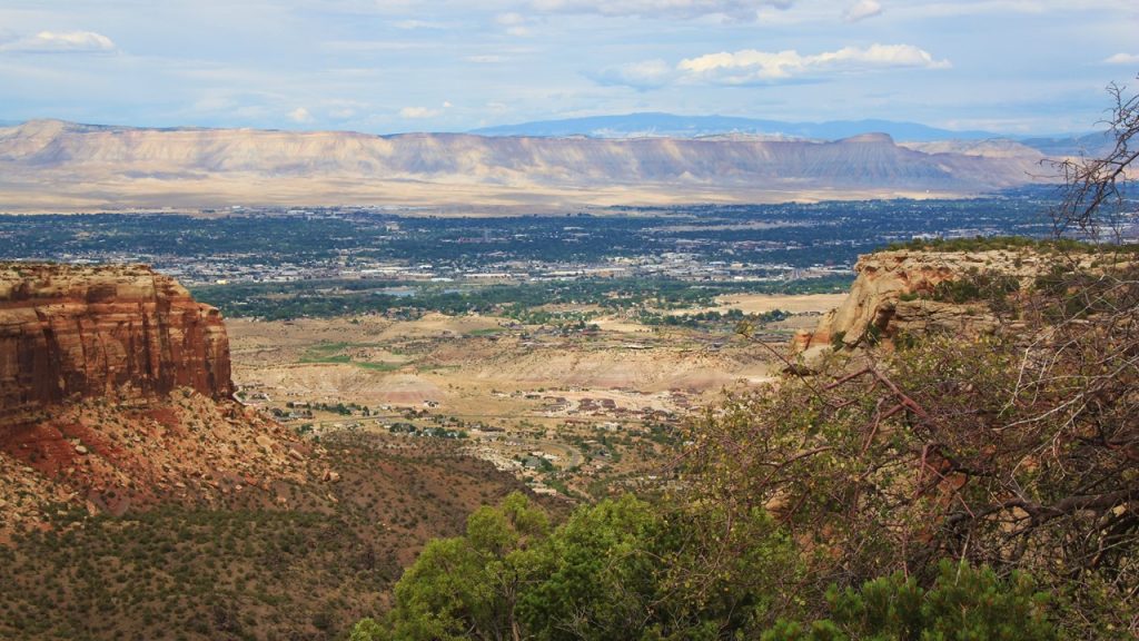
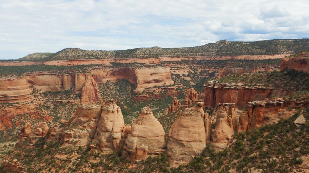
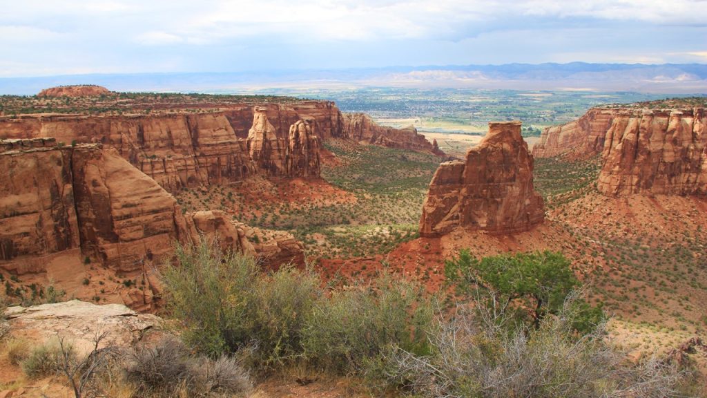
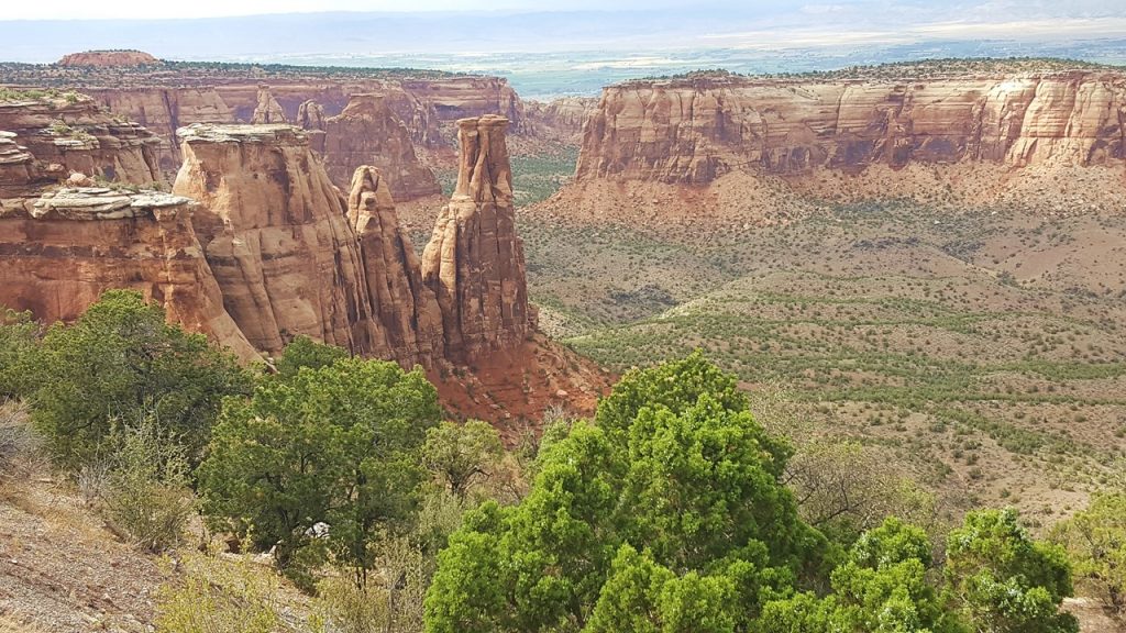
The Colorado Nation Monument
After lunch, we decide to take one last scenic drive along the 26-mile Rim Rock Drive of the Colorado National Monument Park. Colorado National Monument Provides some great views of the town of Grand Junction, towering columns, and red rock canyons. The drive ascends to the top of a mesa and follows its edge along every nook and cranny. At the end of the drive before the descent off the mesa, we stop and visit the Visitors’ Center where the Ranger tells us that we just missed seeing a group of the park’s Bighorn Sheep.
Grand Junction from Red Canyon Overlook on Colorado National Monument Rim RoadUte Canyon from Colorado National Monument Rim RoadArtist Point from Colorado National Monument Rim RoadIndependence Monument at Colorado National Monument
Our final drive is to the airport where we drop off our Jeep rental car and call the hotel for a shuttle ride back. After showering, we enjoy drinks at the hotel’s old-time bar where a live musician is performing. Then, it is off to bed for a very early rise the next morning, and flights back to Orlando. A Great Trip.
Exploring & Rafting Arches & Cataract Canyon in Utah
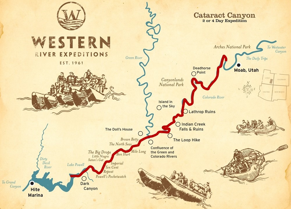
Part 4 – Rafting the Big Drops to Lake Powell
Rafting Cataract Canyon Map
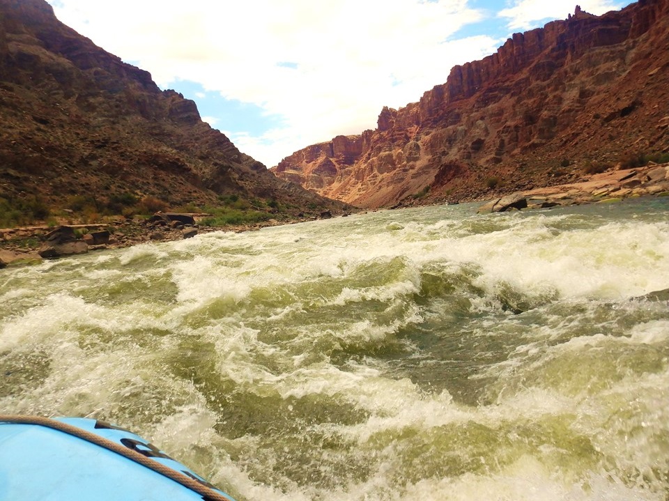
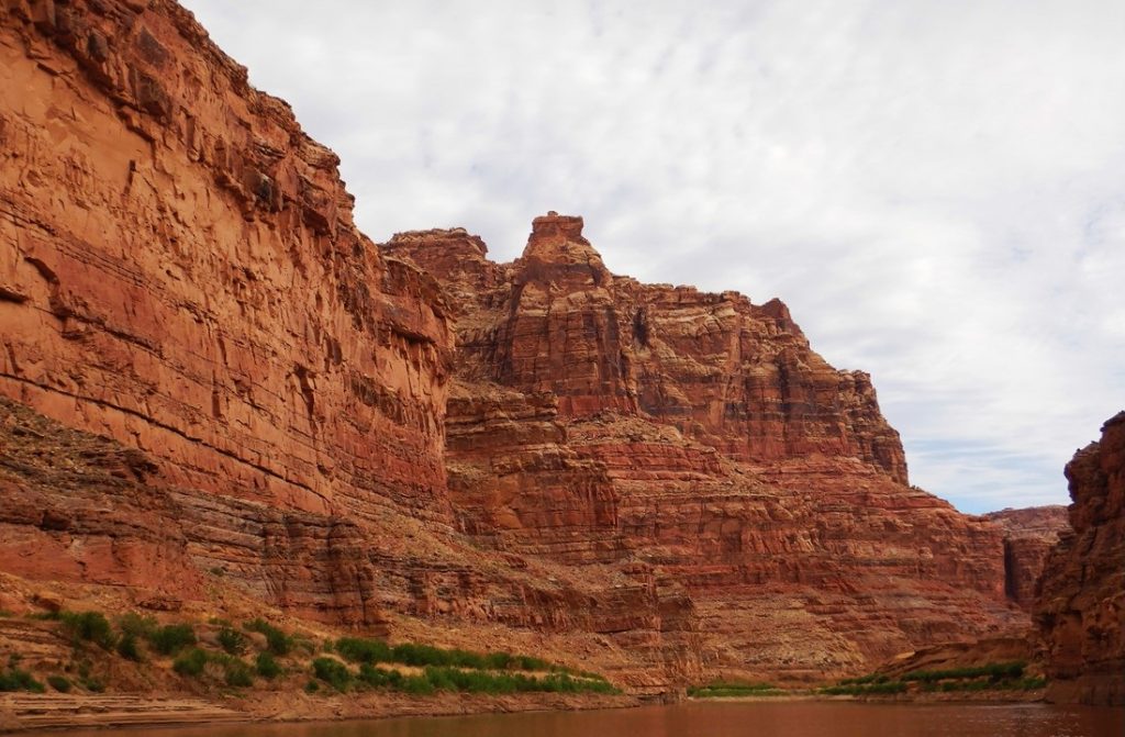
Thursday morning began with a large number of sleep-deprived campers as many had improvised during the night’s rains. The staff, who usually slept in the open on the boats, had huddled down in hastily assembled tents and umbrellas, and many guests needed to dry out. The rain was still coming down, but the coffee was ready on time, and by the time the “Big Breakfast” was ready, the rain had stopped. The “Big Breakfast” was eggs cooked-to-order, hash browns, sausages, and berries. After breakfast, it was time to clean-up and pack-up wet chairs, wet cots, wet tarps, and wet tents, and load the boats for the day of the most serious rapids. We were hopeful that the sun would be available later to dry everything. Rapids #11 through 14 were straight-forward, but rapid #15 – Capsize Rapid – saw us lose our first person overboard. They were immediately recovered, however. We continued through Rapid #20 – Ben Hurt Rapid – before pulling over to the left bank at Big Drop Beach so that the guides could scout the Rapid #21 – Big Drop 1! Big Drop 1 is the first of 3 very large, technical, class 4-5 rapids, and each requires an assessment and plan to negotiate. The guides re-board the rafts and we set off on the rollicking ride down Rapid #21. Then we repeated the process for Rapid # 22 – Big Drop 2 Little Niagara – and for Rapid #23 – Big Drop 3 Satan’s Gut. All goes well for Rapid #22, but our boat takes Rapid #23 backwards, and Mary Jane does not see the drop coming and is tossed out of the boat. Our guide, Colston, immediately pulls in his oars, moves to the side of the boat, grabs her, and hauls her back in! The following few rapids were again of class 2-3 and they allowed us all to recover from our excitement. Next, we pulled to shore for a lunch of cold cuts with fruit. We then re-board the boats for a few minor rapids before reaching the official end of the cataracts and take the boats to shore to re-raft the boats back together and to attach the motors. While this is happening, the guests are allowed to drift/swim down the river to be picked up downstream. Because the height of Lake Powell is so low, a few riffles now exist downstream of this point which allows us to ride feet-first through some minor white-water. After being picked-up downstream, we can again be on the rafts without lifejackets, and we enjoy drying off in the sun. We motor the rafted boats down to “Cove Canyon” where we stop to set up camp for the night. The camp is on a narrow, sandy beach with a small rise, and camp set-up goes fine until a huge set of wind gusts come down the canyon and knocks everything down. Tents turn over, the bathroom tent blows into the river and requires rescuing, and sand covers and permeates everything! The event only lasts 20 minutes, but the mess and chaos it causes has people hauling boulders to anchor their tents, sand being shook out of everything, and causes the bathroom tent to have be repositioned. Despite this, the guides have now dressed-up in “formal” attire, (ties, dress shirts, dresses) and hand-deliver shrimp cocktails to all the guests at their tents, followed by celery and ranch dressing. Meanwhile, the grill is set up and ribeye steaks are being cooked along with corn, broccoli and cheese, shredded potatoes and cheese. Thankfully, the winds die down and dinner is a relaxing and enjoyable affair. To join the mood, Rocky fashions his sheet into a toga and Julie dons her elephant pants – the dressy things we have! Dessert was vanilla ice cream with hot “dump” cake and strawberries. The happy group finishes with a rousing chorus of “Happy Birthday” for a young girl on the trip who turned 13 that day! Thankfully, the rest of the night was peaceful and uneventful, and we slept like babies.
Facing the Big Drop RapidsRelaxing after the RapidsOur Final Camp at River Mile 187.5Our Women River Guides
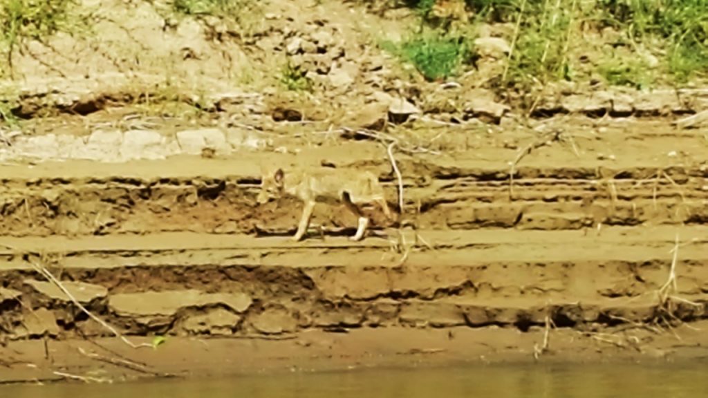
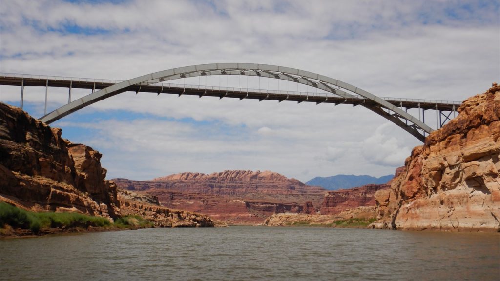
Friday morning everyone slept-in a bit given the adventures of the previous day and the peacefulness of the night. Breakfast was coffee, French toast with fruit and grapefruit. We packed up our tents, tarps, sleeping bags, cots and chairs for the last time and loaded the boats. The storms of the previous night upstream filled the river with red sand and the river had turned brown with mud and debris. We navigate our way along avoiding the debris piles past “Dark Canyon”, enjoying the views of the canyon walls. All along this portion of the river, the banks are lined with 20’-high sediments that are remnants of when Lake Powell was so full the it backed all the up the river past here. Next, we pass “Sheep Canyon” where Powell’s Team took sheep in the valley for food in 1869. Finally, the river narrows and begins to clear, and everyone enjoys one last swim. No sooner do we resume the final leg of our journey when we spot a young coyote scavenging along the bank of the river, unbothered by us. Then, we see the first sign of civilization as we cross under the Hite Bridge. The bridge was named for an early gold miner of the area, Cass Hite, who had killed a fellow miner on the Green River and was sentenced to 12-years in prison. After some prison time, he fell terminally ill and the Utah Governor pardoned him to live out his remaining time (and get him off the State payroll!) But Case Hite recovered and started a small settlement at this important river crossing point until he died in 1914.
Canyon Wall at Sheep CanyonFinal Turn on the RiverCoyote ScavagingThe Hite Bridge
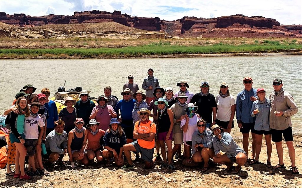
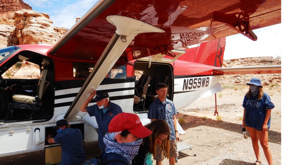
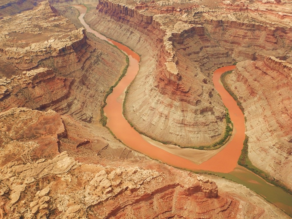
Past the bridge, we pass the “Dirty Devil River” and then turn right to our “Takeout” location, across from Hite Marina, where we unload and take a final lunch of chicken salad in pitas. After lunch, we take a group photo, say our “goodbyes”, and board an old school bus to make the short trip to a small airstrip nearby where we are met by 4 airplanes. Six of us fill the capacity of our small plane, and we take off and fly a spectacularly beautiful 30-minute flight over Canyonlands National Park to Moab’s airport. Along the way, we observe the “Needles” area of the park and see the “Dollhouse” from the air. We can also see what the storm did to the rivers’ colors as the Colorado River upstream of the confluence is clearly colored “green”, while the Green River has turned a muddy “Red” which then colors the Colorado downstream of the confluence – a “Christmas” effect that is rare in the Park! Upon landing, we take an air-conditioned bus 20-minutes back to our meeting point where we say our final goodbyes to friends, old and new, and the trip ends.
Unloading at the LandingThe Travel Group PictureLoading the Plane to MoabNorth Edge of Lake Powell from the AirThe Needles Area from the AirThe Confluence of the Colorado and Green RiversCanyonlands Park from the Air
The Canyonlands area of southern Utah was one of the last Continental United States areas to be explored. Major John Wesley Powell was the first non-native American to travel and explore the river in 1869. The Colorado River upriver of its confluence with the Green River was originally called “The Grand River” until the State of Colorado forced a name change in 1921. Until rugged inflatable rafts became available after World War II, only a few dozen expeditions had ever managed to navigate this part of the river.
Rafting Cataract Canyon Map
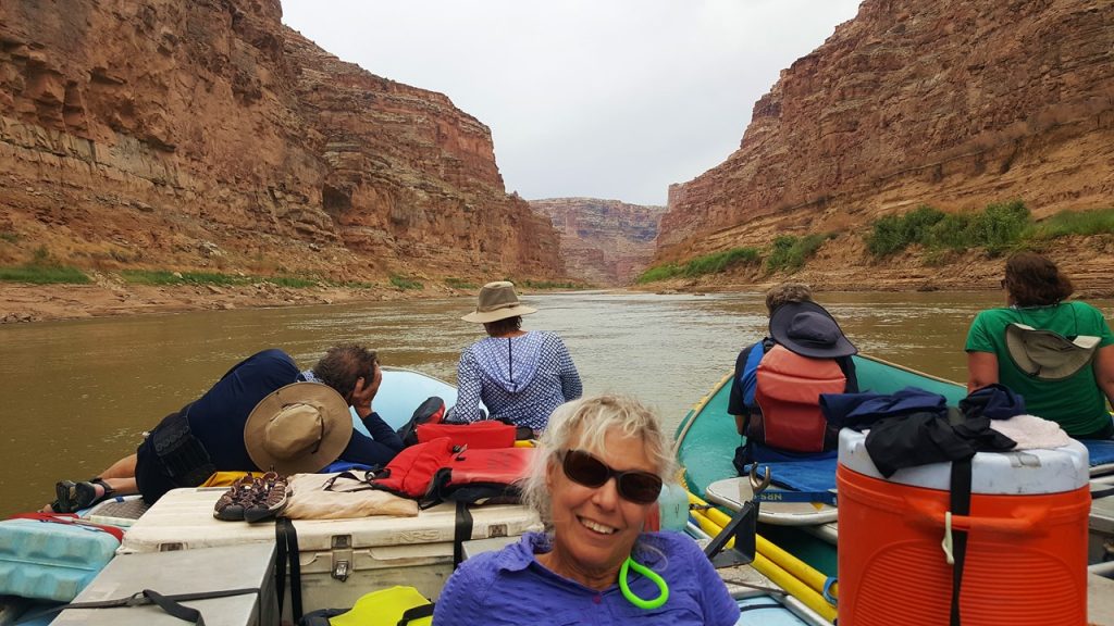
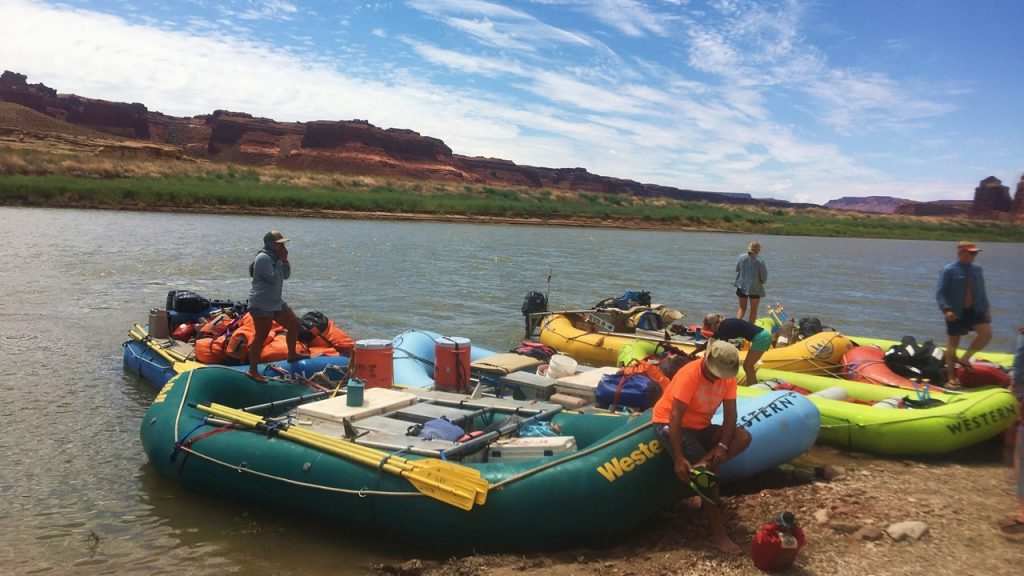
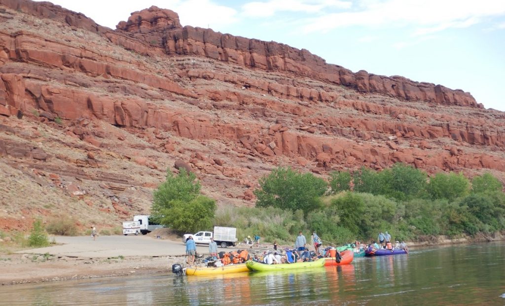
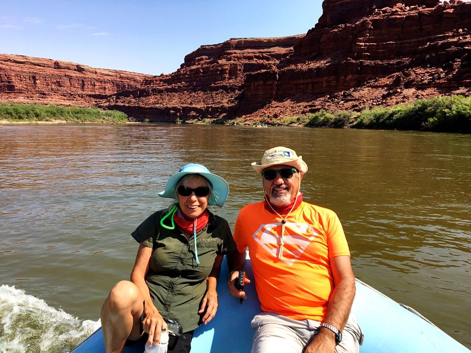
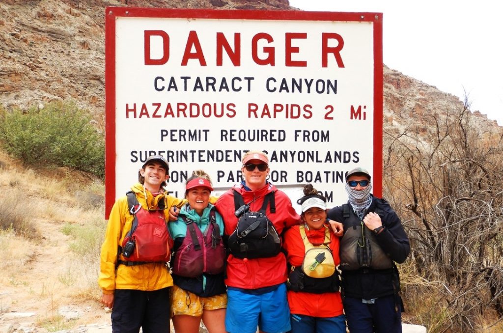
Tuesday morning, we arise, eat breakfast, and check out of our hotel and meet our Trip Group for the short bus ride to the boat ramp. For our expedition, 26 guests with 7 rafts (2 paddle-rafts and 5 oared-rafts), and 7 guides would launch from the boat ramp at Bootlegger Canyon just upriver from Potash and ~54 miles from the confluence with the Green River. Our group was an eclectic mix of families and retirees spanning from 10-70 years old, (one must be at least 10 to take the trip, and 12 if the water is at higher levels). After storing our gear in waterproof bags, we boarded the 5 passenger rafts (2 of the oared rafts were for gear only) and began our adventure down this flatwater part of the trip.
Loading the Rafts
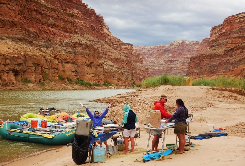
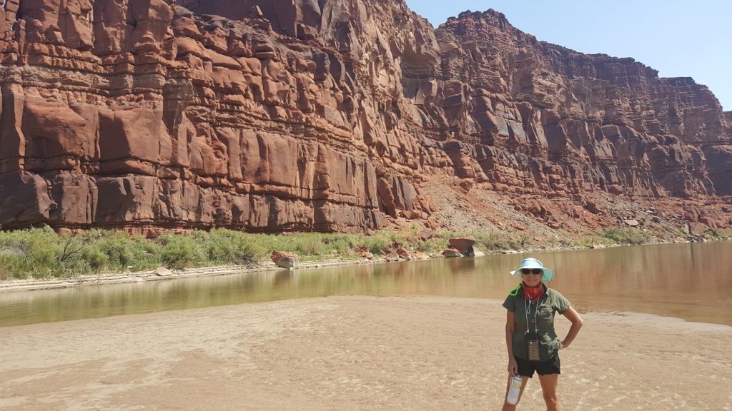
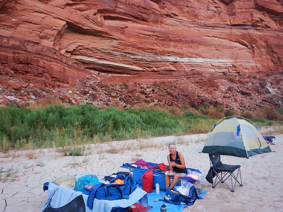
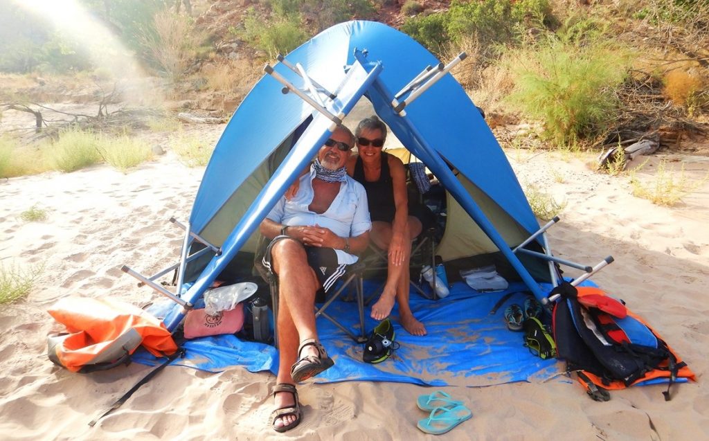
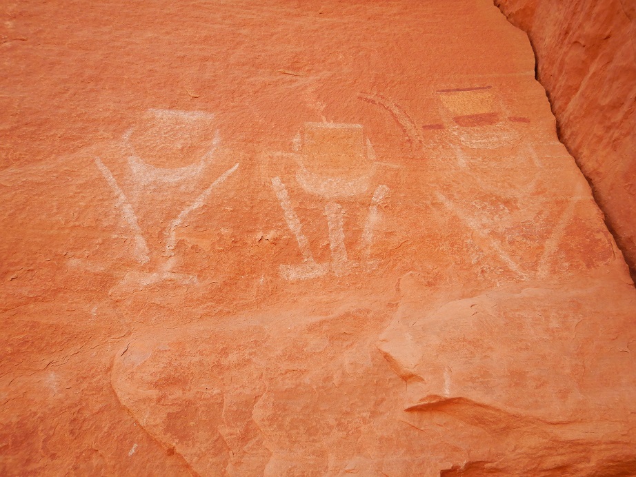
The waters are calm in this part of the river, and so we raft together boats into groups of 3 and 4 and accelerate our trip downriver with a small outboard motor located on each grouping. We enjoy the spectacular scenery and introduce ourselves to each other before taking a “swim-break” in the water after an hour travel. After 16 miles of travel, we are at the closest approach to Dead Horse State Park, and soon after we stop for lunch on a convenient river sandbar. Lunch is cold-cut sandwiches and chips with ever-present water and lemonade to drink. After lunch, we travel again until we get to Lathrop Canyon where we put ashore for a 1/2 -mile hike in the heat to an ancient granary storage site and various petroglyphs. This area of the canyon is visible from the White Rim Overlook in Canyonland National Park. After the hike, we re-board the boats and travel a short distance to our campsite for the night at an area nicknamed “The Corner Pocket” – a large sandbar that has room for our group to pitch tents for the night. Given the hot temperatures, we choose to sleep outside in the open tonight, but we set-up a tent so that our friend, Mary Jane, and Julie have a changing area with a modicum of privacy. That night, we played games while the staff prepare dinner. Appetizer is tortilla chips with fresh guacamole and bean dip, and this is followed by dinner of BBQ chicken with salad and green beans, with chocolate and vanilla cakes for dessert. That night the sky was clear, and the stars shone brightly, but the temperature stayed in the 80’s all night until ~2:30am when a sudden wind-gust toppled a number of unoccupied tents.
Julie on the Colorado RiverRocky & Julie on the RaftGrainery across from Lathrop CanyonAt Corner Pocker Campsite
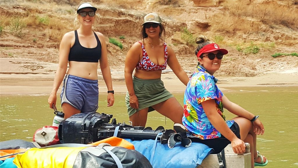
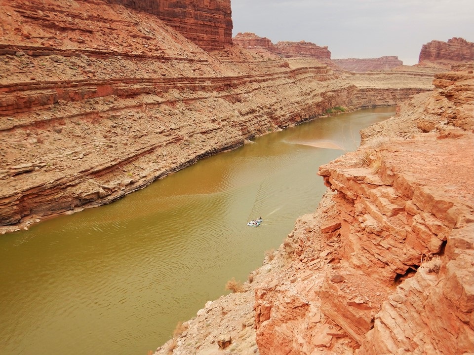
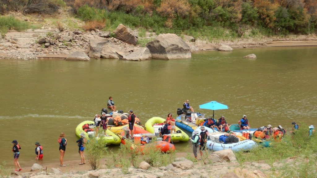
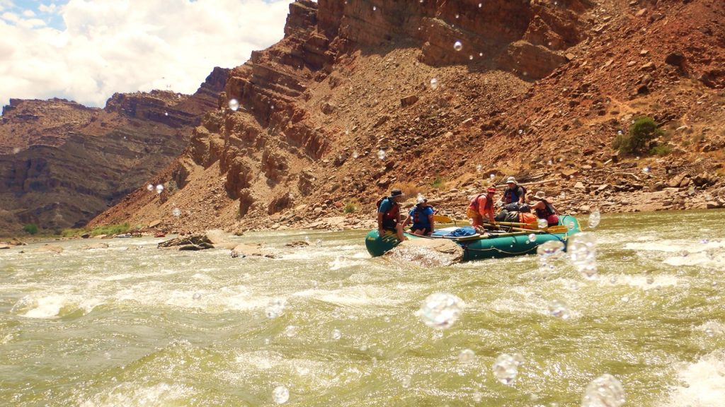
Wednesday morning the (cowboy) coffee was ready by 6:15am and we enjoyed a breakfast of blueberry pancakes, bagels, and turkey sausage before breaking down our camp and repacking our belongings. The National Park Service Rangers showed up in a boat just to check-in and make sure everything was going well, and once we were ready, we set off again downriver. The day is overcast with rain on-and-off, but a welcome relief from the heat of the past 3 days. After a short distance, we came upon a part of the river known as “The Loop” which offered those of us who were interested, the opportunity to disembark the boat and ascend 500’ over the saddle between the double-back bend in the river. While Rocky joined the hikers, Julie rode the rafts the 3-miles around “The Loop” and everyone rejoined on the other side. A short seven miles later and we reached the confluence of the Colorado and Green Rivers, and lifejackets were now required to be worn in the rafts by all participants. A short mile later, we stopped at a “Ranger’s Box” to register our group for campsites for the next two nights, and then, we entered the cataract portion of the river. After passing “The Dollhouse”, (a series of formations on the top of the cliff’s edge in the “Maze” part of the Park, named innocently by Powell’s daughter), we stop at “Lower Red Lake Canyon” for lunch where we saw two deer getting a drink from the river. Lunch was cold-cuts or peanut butter and jelly in a tortilla with fruit and leftover cake. While we enjoyed lunch, the staff stowed the outboard motors, separated each of the rafts and each guide took control of 1 boat. The two paddle boats were led by Jacob and Kelsey, respectively, and they principally were manned by two families from Chicago (9 guests on one boat) with two couples and two individuals joining them (6 guests on the other boat). Two of the oared boats were carrying gear only and were led by Hank (trip leader) and Paco. Finally, the other 3 oared boats were led by Spencer (2 young guests with gear), Riley (4 guests) and Colston (5 guests including us). With everything secure, we were set to run the first 10 rapids (#1- Brown Betty – through #10) of Cataract Canyon located over the next 4 miles. This set of rapids are only Class 2 and 3 but serve as a good introduction for what was ahead. With the water from both rivers now channelized in the Canyon, the color (redder), temperature (colder) and speed of the flow (faster) were noticeably different than before. The running of the rapids went well except for one boat getting stuck on a rock in Rapid #4 and requiring bouncing and work by the participants to get free. At the end of the 10 rapids, we went ashore for our night’s camp at “Top Ten”, stopping early for time to swim, play games (spike ball, cornhole) and enjoy a frozen popsicle. Because of the day’s rain, we set-up our cots and gear inside a tent although many other again chose to sleep in the open air. For dinner, we had grilled salmon and salad with a fruit bowl and watermelon for dessert. The National Park Rangers also stop-by to do an assessment of our guides and camp. They go through an extensive checklist of procedures, certifications, and questions to issue a grade for the Western River Expeditions Company. These assessments only happen 2-3 times per year but are extremely important because 3 failures within 5 years will bar them from using the river for the next 5 years! However, it was a comfortable night, and everyone finally settled in about 10:00pm until the skies opened and a deluge occurred between 1:30 and 3:00am. While we were fine within our cozy tent, those that had chosen to sleep under the stars scrambled to cover themselves with tarps, umbrellas, and tents, or suffered a cold, wet night.
Julie on Raft from atop the Loop CrossoverUnloading Rafts while Registering after ConfluenceGuides Registering for CampsitesStuck on the RocksCamping after First 10 Rapids
Exploring & Rafting Arches & Cataract Canyon in Utah
Part 2 – A Day in Canyonlands National Park’s Islands in the Sky Area
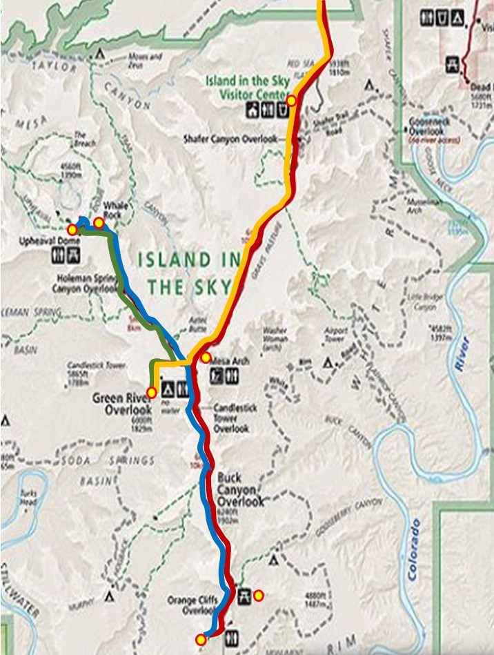
Monday morning, we again arose early, had breakfast at the hotel, and began our 45-minute drive to Canyonlands National Park’s northern entrance. Canyonlands Park is divided into three distinct areas: the northern “Islands in the Sky” area; the southeastern “Needles” area, and the southwestern “Maze” area. Given the size and distances involved, we decided to explore only the “Islands” area.
Canyonland National Park Map
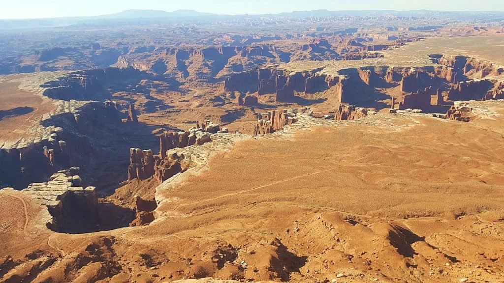
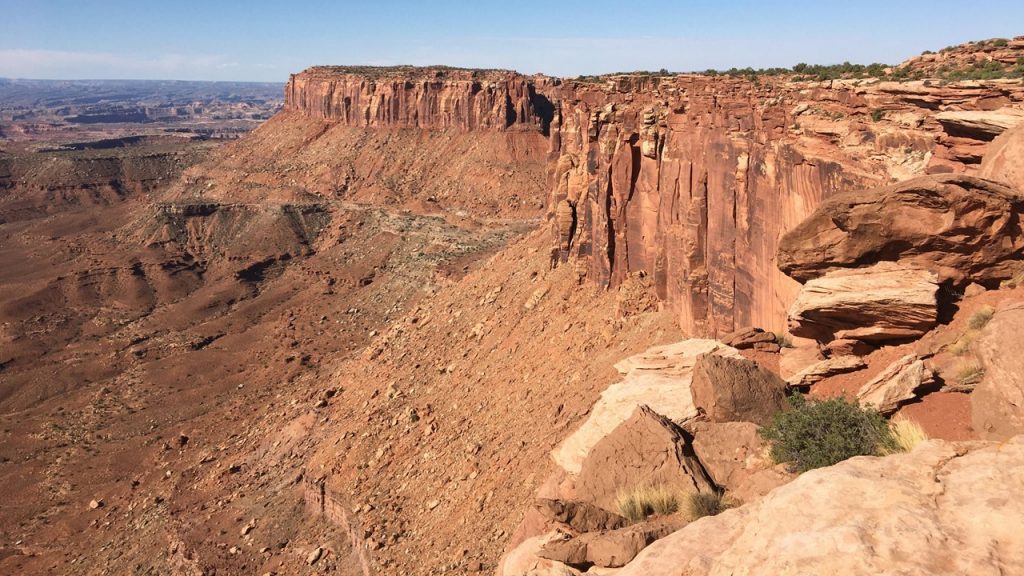
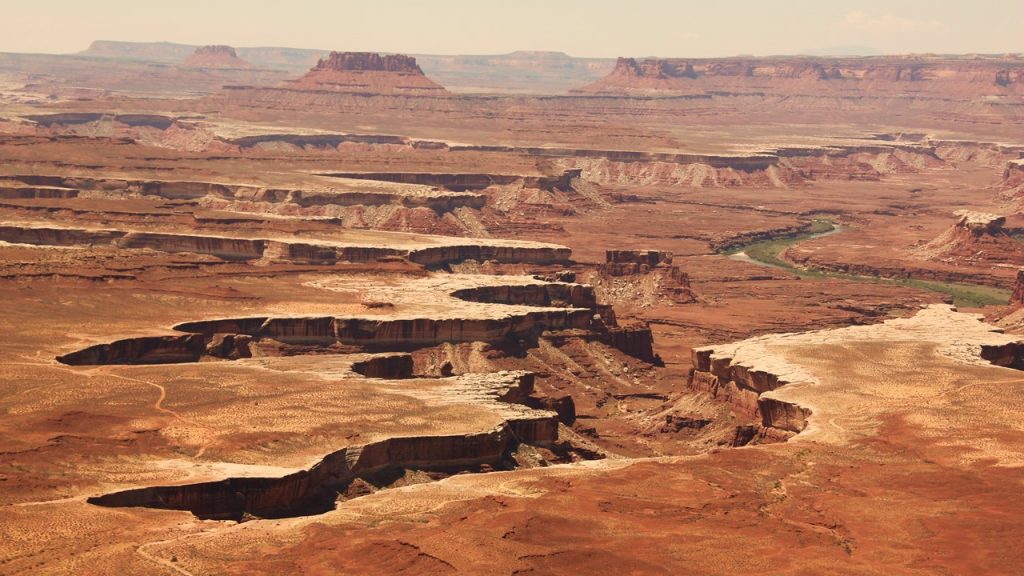
Again, the park was open, but the gate office and visitor’s center were closed when we entered. We took the park road south to near its end and began the “White Rim Overlook” hike (1.8 miles) first, due to the anticipated limited parking there. Along the way we encountered 4 mule deer before reaching the viewpoint from which we could see the Colorado River, Monument Basin and the La Sal Mountains. Upon returning to the car, we continued to the southern end of the road to begin the 2-mile hike along the “Grand Viewpoint Overlook”. This hike follows the canyon’s edge and provides spectacular views of not only the Colorado Canyon, but also the Green River Canyon, as they head to join at The Confluence.
Canyonlands White Rim ViewCanyonlands Grand ViewCanyonlands Grand View of Green River
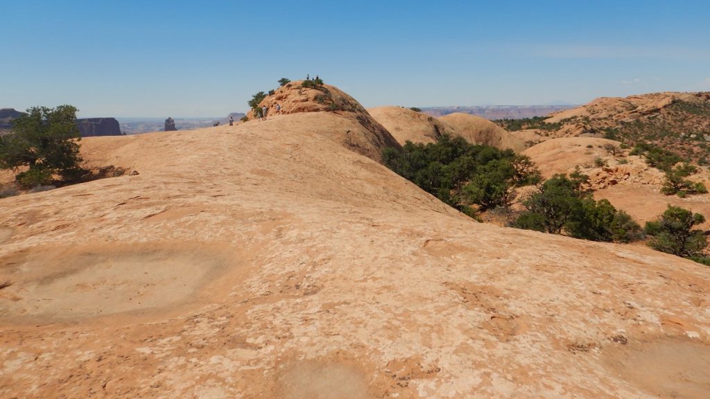
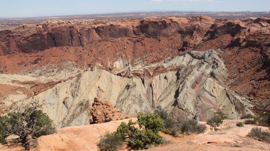
Next, we drove to the most northwest part of the park to climb “Whale Rock” – a 1-mile hike and scramble along “slick rock” surfaces to a high, 360-degree viewpoint, complete with a cooling breeze. After returning to the Jeep, it was only a short drive to the trailhead for “Upheaval Dome” overlook – a massive crater from either a meteor impact or eroded salt uplift, and a place where we observed Bighorn Sheep tracks.
Canyonlands On Whale RockCanyonlands Upheaval Dome Crater
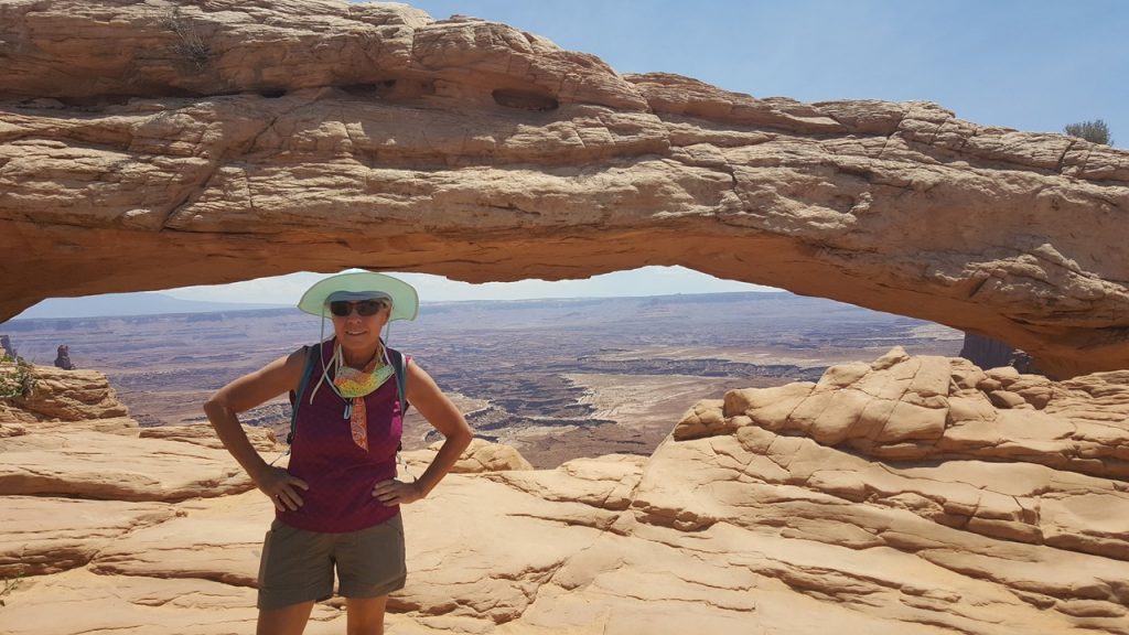
It was past noon when we made it back to the Jeep, so we ate a lunch/snack and took a short drive to the “Green River Overlook”, and then hiked ½-mile to the famous “Mesa Arch” where we encountered the most people we’ve seen on the entire trip. On the way out of the park, we stopped at the Visitor’s Center which was now open and reported our wildlife sightings to the ranger. Apparently, deer were rare in the park, but Bighorn Sheep have been sighted over in the canyon areas along the Green River.
After returning to the hotel and showering, we went window shopping in downtown Moab and ate a soup and salad dinner at the local Brewery Restaurant. Then, we returned to our hotel to finalize our packing for the next day’s beginning of our River Rafting Trip.